
Worsening Drought: Extreme Drought Enters Bedford County, Moderate Drought Expands

The Southern Tennessee Weather Blog is proudly presented by Heritage South Community Credit Union.
We Help When Others Won’t!
Visit https://www.heritagesouth.org/ today to see how HSCCU can help YOU!
Well, I wish I had better news in the rain department. The latest U.S. Drought Monitor was released this morning, and drought conditions have taken another significant step in the wrong direction across Tennessee. Here in Southern Middle Tennessee, the biggest change is in Bedford County, where a portion of the county has now been upgraded to D3 Extreme Drought. According to the National Weather Service in Nashville, Bedford County is currently the only Middle Tennessee county containing D3 conditions, while D2 Severe Drought also remains in portions of Bedford, Wayne and southern Perry Counties. Most of Middle Tennessee is now classified in D1 Moderate Drought, and nearly the entire region is at least Abnormally Dry.
Statewide, Bedford County is only one of two areas in Tennessee currently experiencing Extreme Drought, with the other D3 area located in Lauderdale County in far West Tennessee near the Mississippi River. And unfortunately, this isn't simply a case of missing one or two good thunderstorms. The drought has developed rapidly over the past several weeks, fueled by a combination of persistent heat and a serious lack of widespread, meaningful rainfall.
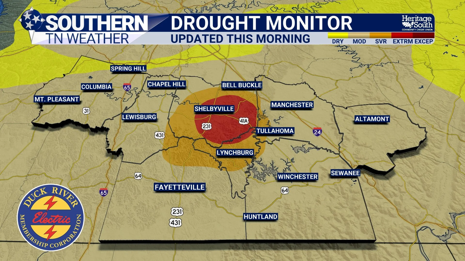
DROUGHT MONITOR - UPDATED THIS MORNING
Just How Quickly Has the Drought Worsened?
Pretty quickly. The National Weather Service notes that most of Tennessee has experienced rapid drought development and degradation over the past four weeks, while significant improvement has been essentially nonexistent. If your yard has gone from green to crunchy seemingly overnight, the rainfall numbers help explain why. During the past 30 days, most of Tennessee has received 2 inches of rain or less. In general, that's only about 50% or less of normal rainfall, while some of the driest areas have received 25% or less of what would normally fall during that period. The relentless September heat certainly hasn't helped.
For much of the past several weeks, we've been stuck beneath persistent high pressure with temperatures frequently climbing into the 90s and, on several occasions, flirting with or exceeding 100°. That heat increases evaporation from the ground and water surfaces while vegetation continues losing moisture through transpiration. When rainfall doesn't replace that lost moisture, soils gradually become drier and vegetation becomes increasingly stressed. Think back to the moisture savings account analogy we've used before. Earlier rainfall deposited moisture into the account. Every hot, sunny and rain-free day makes another withdrawal. Eventually, if we keep making withdrawals without meaningful deposits, the balance gets pretty low.
We're seeing the consequences of that now. This isn't just a Southern Middle Tennessee problem, either. The broader southern United States has been trapped beneath much of the same hot and dry pattern. While locations farther north received tremendous amounts of rain during the past week, including localized totals of 6–8 inches from portions of the Upper Midwest into the Ohio Valley, rainfall across much of the South was considerably more scattered and lighter. At the same time, temperatures across much of the South averaged roughly 5–10° above normal, with some areas even hotter. In other words, some parts of the country have been dealing with too much water while we've been desperately waiting for it.
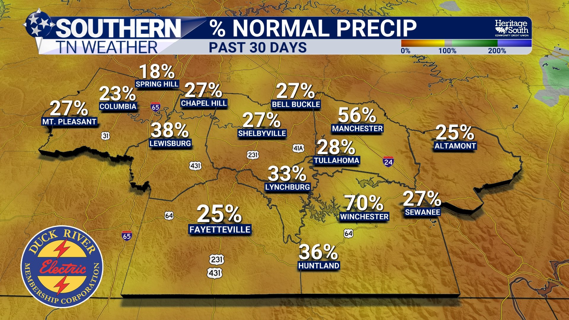
PERCENT NORMAL PRECIP - PAST 30 DAYS
What Does Extreme Drought Actually Mean?
D3 Extreme Drought is the second-highest category on the U.S. Drought Monitor's five-category drought scale. The scale begins with D0 Abnormally Dry, which technically isn't considered drought yet. From there, conditions progress through D1 Moderate Drought, D2 Severe Drought, D3 Extreme Drought, and finally D4 Exceptional Drought. That doesn't mean every creek suddenly dries up the instant an area changes color on the map. The Drought Monitor is designed to represent the broader moisture situation using numerous indicators rather than simply measuring how much rain fell last week.
And we're beginning to see evidence of the drought beyond our brown lawns. The National Weather Service reports that while lower streamflows are normal during this time of year, some locations are running below normal to much below normal, particularly within the Duck River, Elk River and Buffalo River basins. The combination of limited rainfall and seasonally low streamflow has left some rivers and creeks well below normal, while insufficient soil moisture remains an issue even as the agricultural growing season winds down.
That's an important distinction because drought is about much more than whether your grass is brown. Soil moisture, vegetation health, streamflow and longer-term water availability all help tell us how deeply the dry conditions are becoming established. It's also why one good thunderstorm isn't going to erase this. If Bedford County receives two inches of rain from a slow-moving thunderstorm tomorrow, that would certainly be helpful for that particular location, but it wouldn't instantly repair weeks of accumulated moisture loss. Some of that rainfall would replenish the upper layers of soil, some would be taken up by vegetation, some could run off into creeks and streams, and some would eventually evaporate.
To meaningfully improve a drought like this, what we really want is several rounds of widespread, manageable rainfall spread over time. That's much more beneficial than one town getting dumped on while communities ten miles away receive nothing.
Unfortunately, Meaningful Rain Is Still Hard to Find
Our temperatures have FINALLY improved dramatically, but the rainfall forecast isn't nearly as exciting. A few scattered showers remain possible across the Cumberland Plateau this afternoon, but most of Southern Middle Tennessee will remain dry. From there, our weather turns absolutely beautiful heading into the weekend. Highs should generally reach the mid 70s to lower 80s, with much lower humidity, while Saturday morning temperatures fall into the 50s. A few locations on the Cumberland Plateau could even reach the upper 40s.
Great weather for getting outside. Not great weather for fixing a drought.
High pressure and a dry air mass should keep meaningful rainfall out of the forecast through the weekend and into at least the beginning of next week. The National Weather Service's drought statement indicates that rainfall across Middle and East Tennessee during the next seven days is generally expected to total less than one-quarter inch, while considerably higher totals may fall farther west.
There are some signs that another trough and cold front could approach toward the middle of next week, potentially bringing our next opportunity for showers and thunderstorms around Wednesday. However, we're still nearly a week away, and there are differences in the forecast guidance regarding the timing and progression of that system. It's much too early to count on it as meaningful drought relief. There is at least a little more encouraging news when we look farther down the road.
The Climate Prediction Center's 6–10 day outlook currently favors above-normal precipitation across Tennessee from September 30th thru October 4th, although it also favors above-normal temperatures during that same period. Looking even farther ahead, the outlook favors above-normal precipitation for Tennessee during October through December, and the current seasonal drought outlook suggests drought will likely persist during the next several weeks but could gradually improve later this fall and into early winter if those wetter conditions materialize. That's encouraging, but it's important to understand what those outlooks mean. They don't guarantee a rainy October, nor do they tell us exactly how much rain will fall at your house. They simply indicate that the odds are currently tilted toward a wetter-than-normal pattern over those periods. For now, the drought is here, it's worsening, and we still need rain.
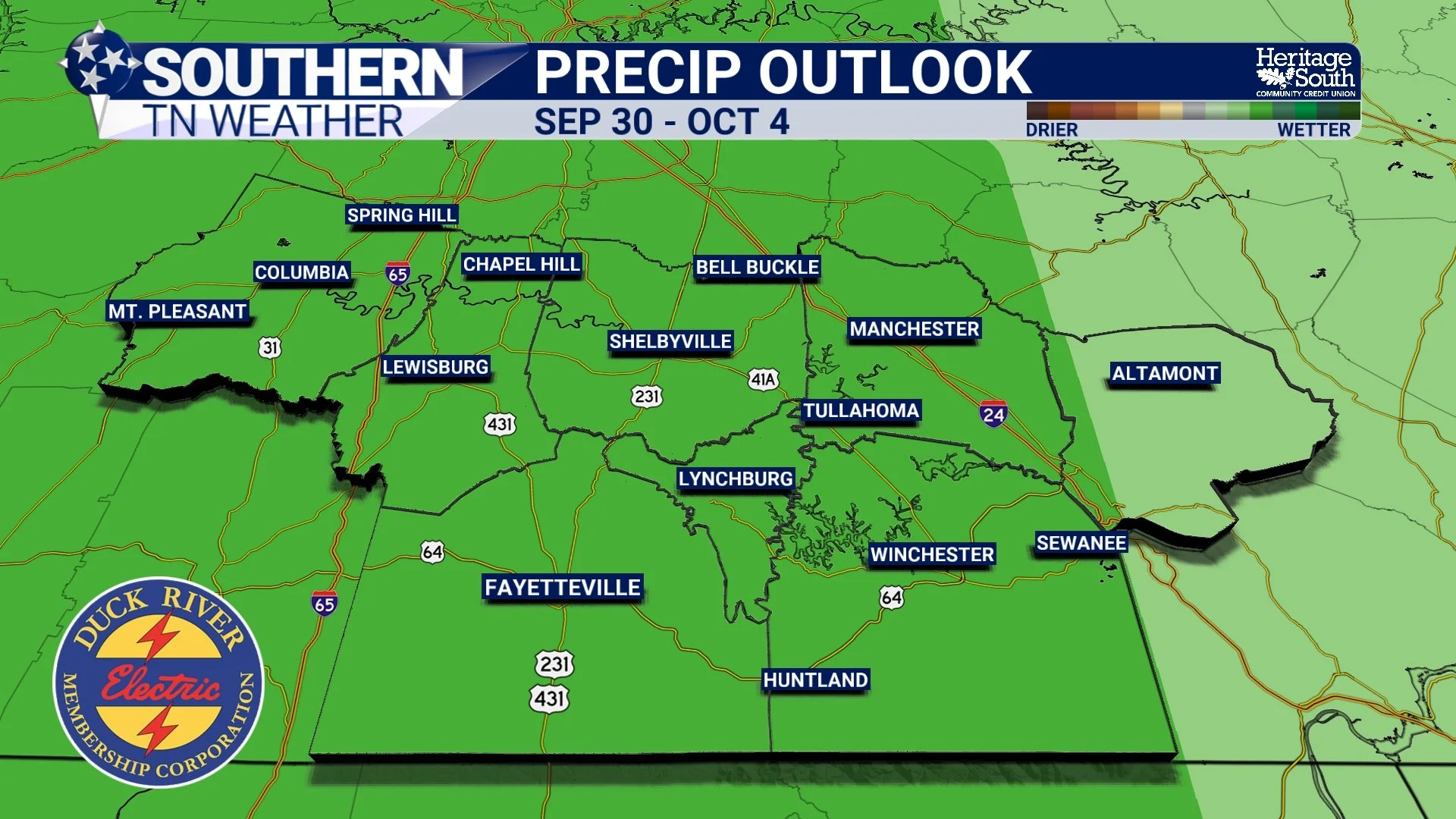
6-10 DAY PRECIP OUTLOOK
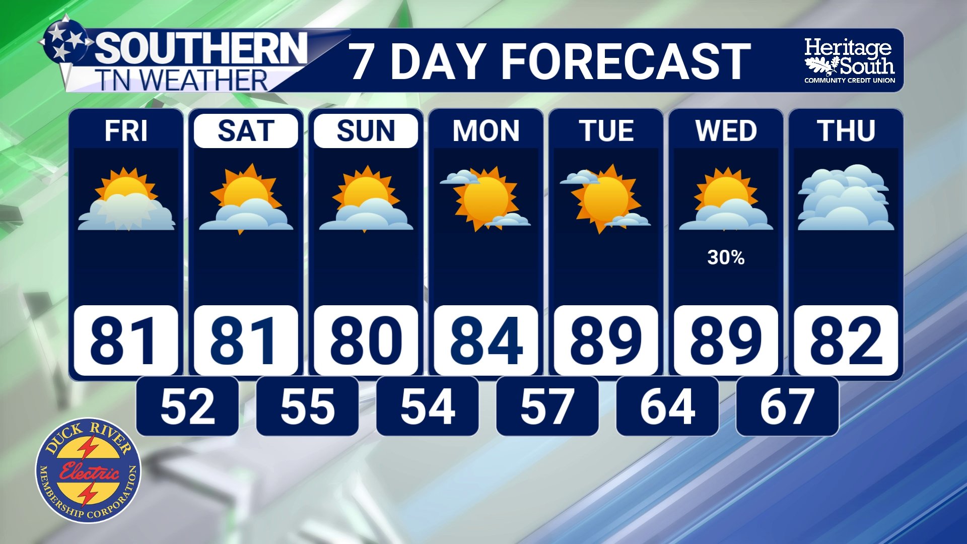
STNWX 7-DAY FORECAST
The Bottom Line 🧾
🔴 D3 Extreme Drought has developed in a portion of Bedford County, making it the only Middle Tennessee county currently containing Extreme Drought.
🌵 Bedford County is one of only two areas in Tennessee currently experiencing D3 Extreme Drought.
🟠 D2 Severe Drought also exists in portions of Bedford, Wayne and southern Perry Counties, while D1 Moderate Drought covers most of Middle Tennessee.
📉 Most of Tennessee has experienced rapid drought degradation during the past four weeks, with little significant improvement.
🌧️ Most of the state has received 2 inches of rain or less during the past 30 days, generally 50% or less of normal. The driest areas have received 25% or less.
🌊 Below-normal to much-below-normal streamflows are being observed in portions of the Duck, Elk and Buffalo River basins.
☀️ Beautiful, cooler weather is expected this weekend, but unfortunately it will also be dry.
🌧️ Forecast rainfall across Middle Tennessee during the next seven days is generally less than 0.25", so meaningful short-term drought relief is unlikely.
👀 Another system could bring rain chances back around the middle of next week, but confidence in the details remains low.
🌦️ Longer-range outlooks offer a little hope, with increased odds of above-normal precipitation during early October and the October–December period.
🌱 Current outlooks suggest the drought may persist for the next several weeks before gradually improving later this fall and early winter if a wetter pattern develops.
📰 Reminder: The Southern Tennessee Weather Blog, presented by Heritage South Community Credit Union, is updated Monday through Friday with fresh, locally tailored forecasts you can trust.
