
Weekend Outlook: FINALLY Some Beautiful Fall Weather!

The Southern Tennessee Weather Blog is proudly presented by Heritage South Community Credit Union.
We Help When Others Won’t!
Visit https://www.heritagesouth.org/ today to see how HSCCU can help YOU!
I don't know about y'all, but after the weather we've endured for most of September, this weekend's forecast almost feels suspicious. No Heat Advisory. No Heat Index values near 110°. No widespread thunderstorms. No severe-weather risk. Just sunshine, low humidity, cool mornings, and afternoon temperatures around 80°. FINALLY!
A much cooler and drier air mass has settled across Southern Middle Tennessee, and it's going to stick around through the weekend. In fact, this will probably be one of the nicest weekends we've had in quite some time, with temperatures running pretty close to normal for late September.
The only thing missing is rain, and considering our rapidly worsening drought, that's unfortunately a pretty important thing to be missing. We'll talk about when our next opportunity for rainfall may arrive in a moment, but first, let's enjoy a forecast that requires very little complaining.
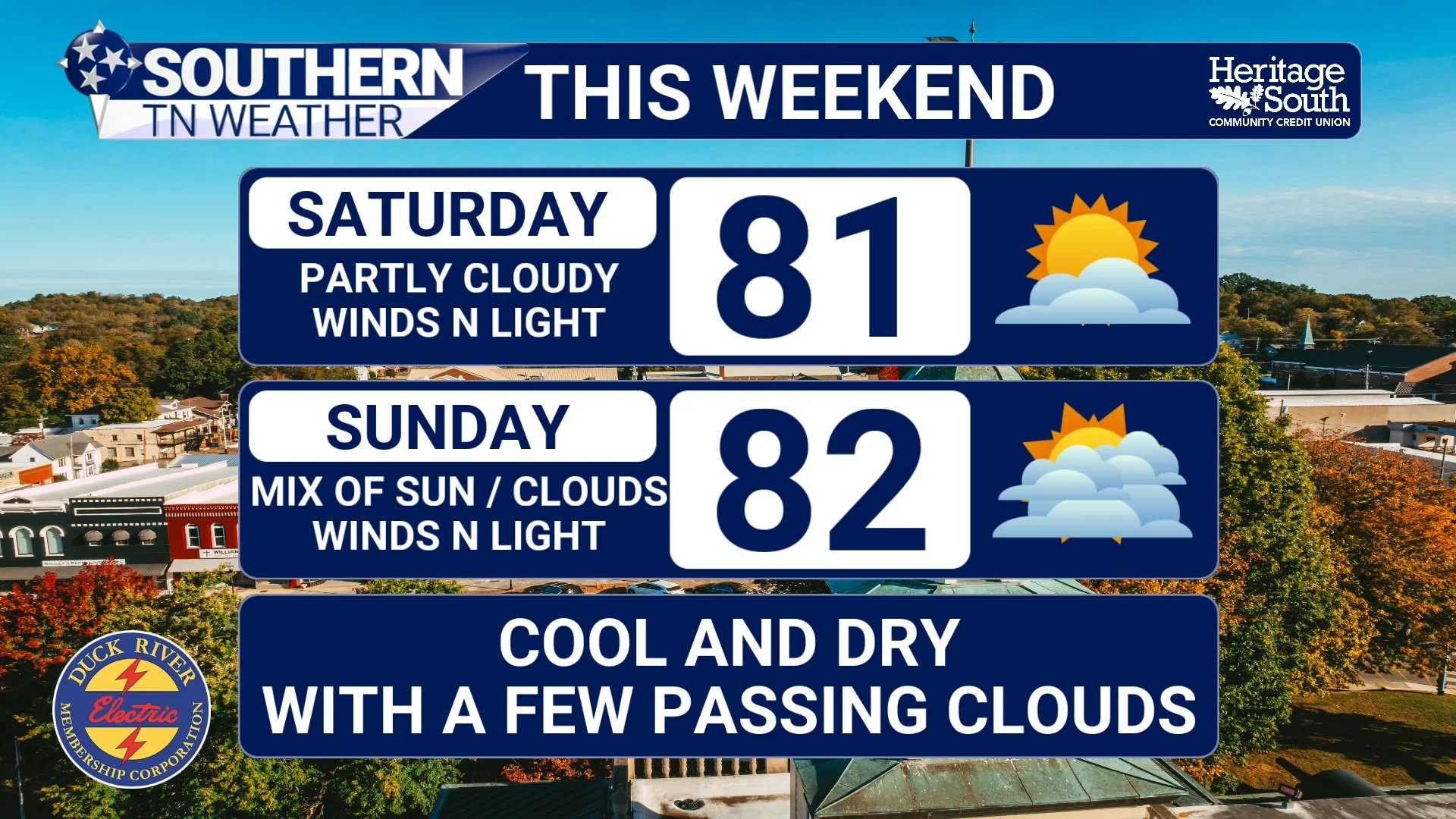
STNWX WEEKEND FORECAST
Cool Mornings, Warm Afternoons & Plenty of Sunshine
Friday is shaping up beautifully across Southern Middle Tennessee as lingering clouds continue clearing and drier air settles into the region. Afternoon highs should generally reach the upper 70s to lower 80s with a light breeze and noticeably lower humidity. Once the sun goes down tonight, we'll really start putting that cooler and drier air to work. With mostly clear skies and relatively light winds, temperatures should fall quickly through the 60s and eventually into the low to mid 50s for many of us by Saturday morning. Some of our colder locations, particularly across the Cumberland Plateau and in sheltered valleys, could even dip into the upper 40s.
And yes, I know what some of you are thinking: “Elijah, there ain't no 40s on my forecast map!” Computer models and even our forecast maps can't perfectly resolve every valley, hollow and creek bottom across Southern Middle Tennessee. On clear, calm nights, the ground loses heat very efficiently through radiational cooling. At the same time, colder air is denser than warmer air, allowing it to drain downhill and collect in sheltered low-lying areas. That means one location could wake up to 54° while a protected valley only a few miles away briefly drops to 49°. We talked about this exact process in Wednesday's weather blog, and this weekend gives us a great opportunity to watch it happen.
Patchy fog will also be possible during the overnight and early morning hours. River valleys and other low-lying areas will be most susceptible, and some patches could become locally dense. Most of us won't have major problems, but if you're traveling early in the morning and suddenly drive into fog, visibility can decrease VERY quickly. Once any morning fog burns away, Saturday looks fantastic. Plenty of sunshine should allow temperatures to recover nicely, with afternoon highs generally between 80° and 85°. Humidity stays low, winds remain fairly light, and there is essentially no meaningful chance for rain.
Sunday is basically a copy-and-paste forecast. We'll start cool once again before warming into the lower to middle 80s during the afternoon beneath mostly sunny to partly cloudy skies. If you've been waiting for a weekend to mow the yard (or dirt), head to a football game, visit a fall festival, work outside, fire up the grill, or simply sit on the porch without immediately becoming one with the humidity... This is the weekend.
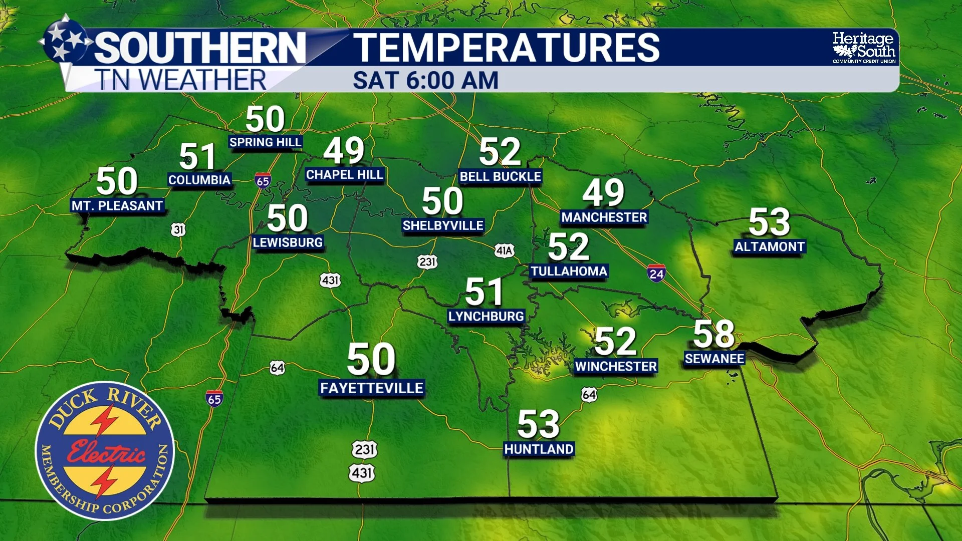
TEMPERATURES - SATURDAY AM
The Drought Is the One Big Downside
As wonderful as this weather will feel, our worsening drought keeps me from giving the weekend forecast a completely clean bill of health. The newest U.S. Drought Monitor released Thursday showed Extreme Drought developing in a portion of Bedford County, with Moderate Drought expanding across a large portion of Middle Tennessee. After weeks of excessive heat and limited widespread rainfall, we desperately need several rounds of good, soaking rain. Unfortunately, we're not getting that this weekend.
The same pattern responsible for our comfortable temperatures and low humidity is also keeping meaningful moisture away. We're essentially positioned between upper-level ridging to our west and troughing farther east, leaving us beneath a dry north to northwesterly flow. That's great if you're making outdoor plans. It's terrible if you're a brown lawn. Dry weather should continue through the weekend and into at least the beginning of next week, so the drought will receive very little help in the short term. Cooler temperatures will at least reduce evaporation compared with last week's brutal heat, but cooler weather alone doesn't replace the moisture we've lost.
For that, we need actual rain. And there may finally be another opportunity showing up later next week.
The Heat Creeps Back... Then Maybe Some Rain?
Enjoy those cool mornings while they're here because temperatures will gradually start climbing again next week. Upper-level ridging is expected to expand across the Southeast, allowing afternoon temperatures to rise from the lower to middle 80s early in the week into the upper 80s and perhaps lower 90s by Tuesday and Wednesday. Before anybody starts throwing tomatoes at me, this does NOT look like a repeat of last week's heat wave.
We're not currently expecting another prolonged stretch of upper 90s, temperatures near 100°, or Heat Index values approaching 110°. Instead, it looks more like another late-September warmup as high pressure strengthens overhead. The more interesting part of next week's forecast arrives toward the end of the week. Forecast guidance is watching an upper-level low developing over the southwestern United States that should eventually begin moving eastward. As that system approaches, southerly winds could begin transporting more moisture back into our region, allowing rain chances to return.
Current forecasts bring roughly 20–40% rain chances back into Southern Middle Tennessee toward the latter portion of next week. But I want to put a BIG asterisk beside that forecast.
There is still considerable disagreement over how quickly this system moves east and how strong it will be. Some guidance keeps stronger ridging over the Southeast longer, which would delay the system and potentially keep us warmer and drier. Other solutions are more progressive and bring moisture and rain chances back sooner. That disagreement is also producing a pretty wide range of potential rainfall totals, so I'm definitely not ready to advertise this as our drought-busting rain. For now, it's simply something worth watching. Considering the drought situation, we'll take every legitimate rain opportunity we can get!
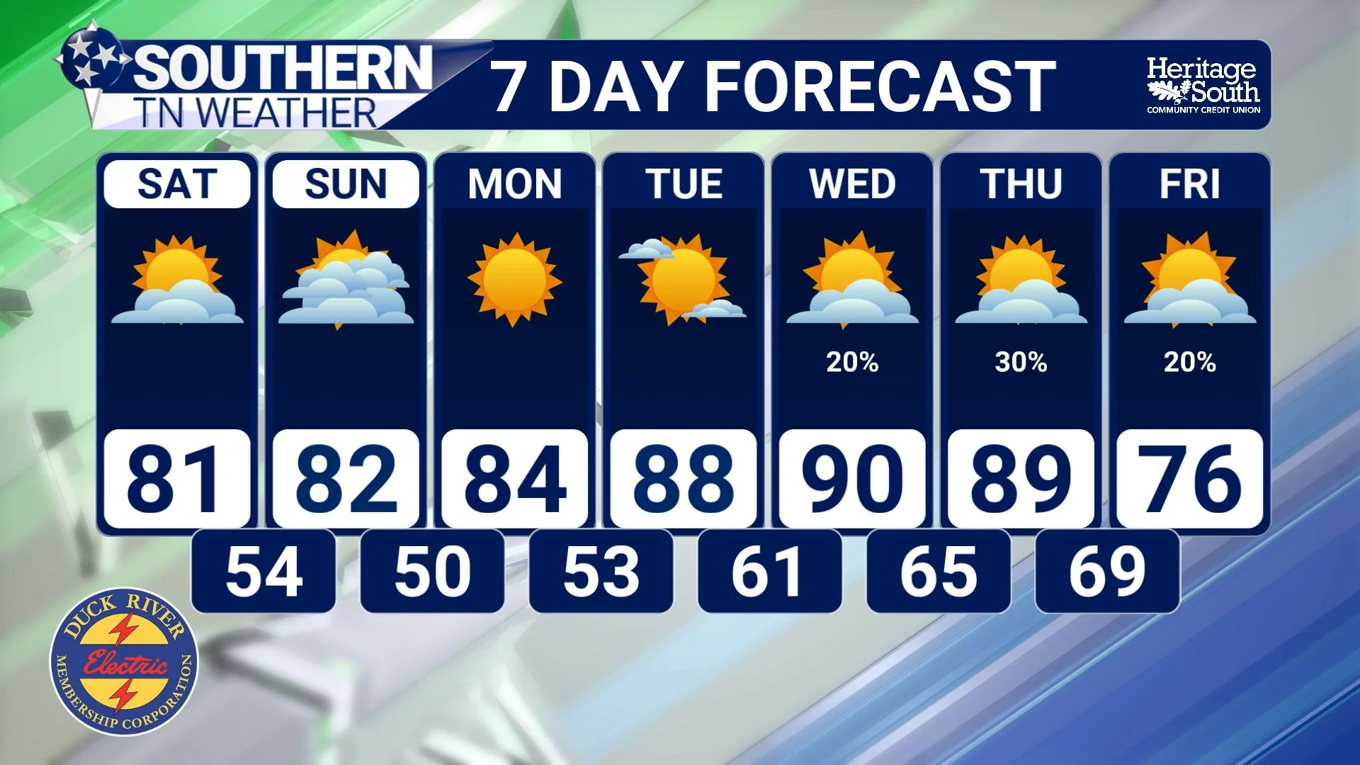
STNWX 7-DAY FORECAST
The Bottom Line 🧾
🍂 A BEAUTIFUL late-September weekend is ahead across Southern Middle Tennessee.
☀️ Friday will be mostly sunny with highs generally in the upper 70s to lower 80s and low humidity.
🌫️ Patchy fog is possible overnight and during the early morning hours, particularly in river valleys and other low-lying areas.
🥶 Saturday morning lows should reach the low to mid 50s, with some colder valleys and portions of the Cumberland Plateau potentially dipping into the upper 40s.
☀️ Saturday looks fantastic with plenty of sunshine, low humidity and highs around 80–85°.
🍁 Sunday brings more of the same, with another cool start followed by afternoon temperatures in the lower to middle 80s.
🌵 Unfortunately, no meaningful rainfall is expected this weekend, which means our worsening drought will receive little help.
📈 Temperatures gradually climb next week, potentially reaching the upper 80s to around 90° Tuesday and Wednesday.
🌧️ Rain chances may finally return toward the latter part of next week, currently around 20–40%, but confidence in the timing and amount of rainfall remains fairly low.
👀 We'll be watching that late-week system closely because Southern Middle Tennessee could certainly use the rain.
📰 Reminder: The Southern Tennessee Weather Blog, presented by Heritage South Community Credit Union, is updated Monday through Friday with fresh, locally tailored forecasts you can trust.
