
Why Do Clear Nights Get Colder Than Cloudy Nights?

The Southern Tennessee Weather Blog is proudly presented by Heritage South Community Credit Union.
We Help When Others Won’t!
Visit https://www.heritagesouth.org/ today to see how HSCCU can help YOU!
After spending what felt like approximately 47 years talking about heat, I finally get to talk about something completely different: cool nights! Our long-awaited cooler air has arrived across Southern Middle Tennessee, and we're heading toward a fantastic stretch of weather later this week and into the weekend. Afternoon temperatures will generally settle into the lower to middle 80s, humidity will be MUCH lower, and nighttime temperatures could eventually tumble into the low to mid 50s. That's almost light-jacket territory!
Those cooler nights also give us the perfect opportunity to answer a weather question you may have wondered about before. Why can a clear night become significantly colder than a cloudy night, even when the same general air mass is sitting over us? You've probably heard meteorologists mention that “clear skies and light winds will allow temperatures to drop quickly tonight,” and there's some interesting physics behind that statement. The answer mostly comes down to something called radiational cooling, and while you've probably heard clouds described as acting like a blanket at night, there's a little more to the story than that.
Where Does the Heat Go After Sunset?
To understand why clear nights get colder, we first need to think about how the ground warms and cools throughout a normal day. During daylight hours, the Sun sends energy toward Earth in the form of solar radiation. Some of that energy is reflected by clouds, the atmosphere and Earth's surface, but a significant amount is absorbed by the ground. The warmed ground then transfers energy into the air immediately above it, helping temperatures near the surface rise.
At the same time, Earth is constantly emitting energy of its own in the form of infrared radiation. During a sunny afternoon, we're generally receiving enough energy from the Sun to offset those losses and continue warming. Eventually, as the Sun gets lower in the sky, that balance changes. Once the Sun sets, the incoming solar energy disappears, but Earth doesn't suddenly stop emitting infrared radiation. The ground continues losing energy throughout the night, causing both the surface and the air immediately above it to cool.
Meteorologists call this process radiational cooling.
You can think of it somewhat like turning off a stove burner. The burner doesn't instantly become cold when you turn it off because it still contains plenty of stored heat, but without a continuing source of energy, it gradually cools. Earth's surface goes through a similar process every evening. The difference between a relatively mild night and a surprisingly chilly one often depends on how efficiently that stored energy can escape.
That's where the clouds come in.
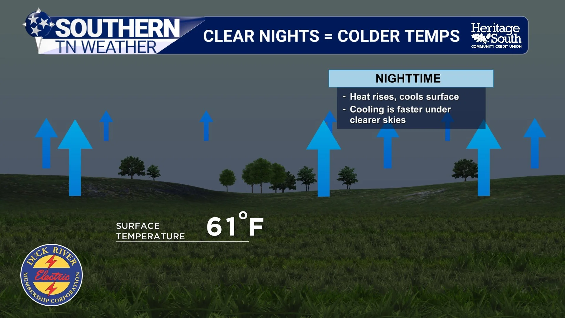
CLEAR NIGHS = COLDER TEMPS
Why Clouds Can Keep the Night Warmer
The common explanation that clouds act like a “blanket” is actually a pretty useful analogy, although clouds aren't literally trapping warm air beneath them like a comforter over your bed.
On a clear night, infrared radiation emitted by Earth's surface has a relatively easy path upward through the atmosphere. As the ground steadily loses energy, its temperature falls, and the layer of air closest to the surface cools along with it. If skies remain clear for many hours, that cooling can become quite efficient.
When clouds are overhead, the energy exchange changes. Clouds are made of tiny water droplets and/or ice crystals that are very effective at absorbing infrared radiation emitted by Earth's surface. The clouds then emit infrared radiation themselves in all directions, including back downward toward the ground. That downward radiation reduces the rate at which the surface loses energy, so temperatures generally don't fall as quickly as they would beneath a clear sky.
That's the real science behind the “cloud blanket.” Clouds aren't creating extra heat, and they don't prevent all of Earth's energy from escaping into space. Instead, they slow the rate at which the surface cools.
You can sometimes watch this happen during the course of a single night. Temperatures may drop quickly for several hours beneath a clear sky, only to level off after a thick deck of clouds moves overhead. The opposite can happen as well. A cloudy evening may remain relatively mild until the clouds suddenly clear after midnight, allowing temperatures to begin falling much more rapidly.
Cloud cover is therefore one of the most important things meteorologists consider when forecasting overnight low temperatures, but it certainly isn't the only ingredient.
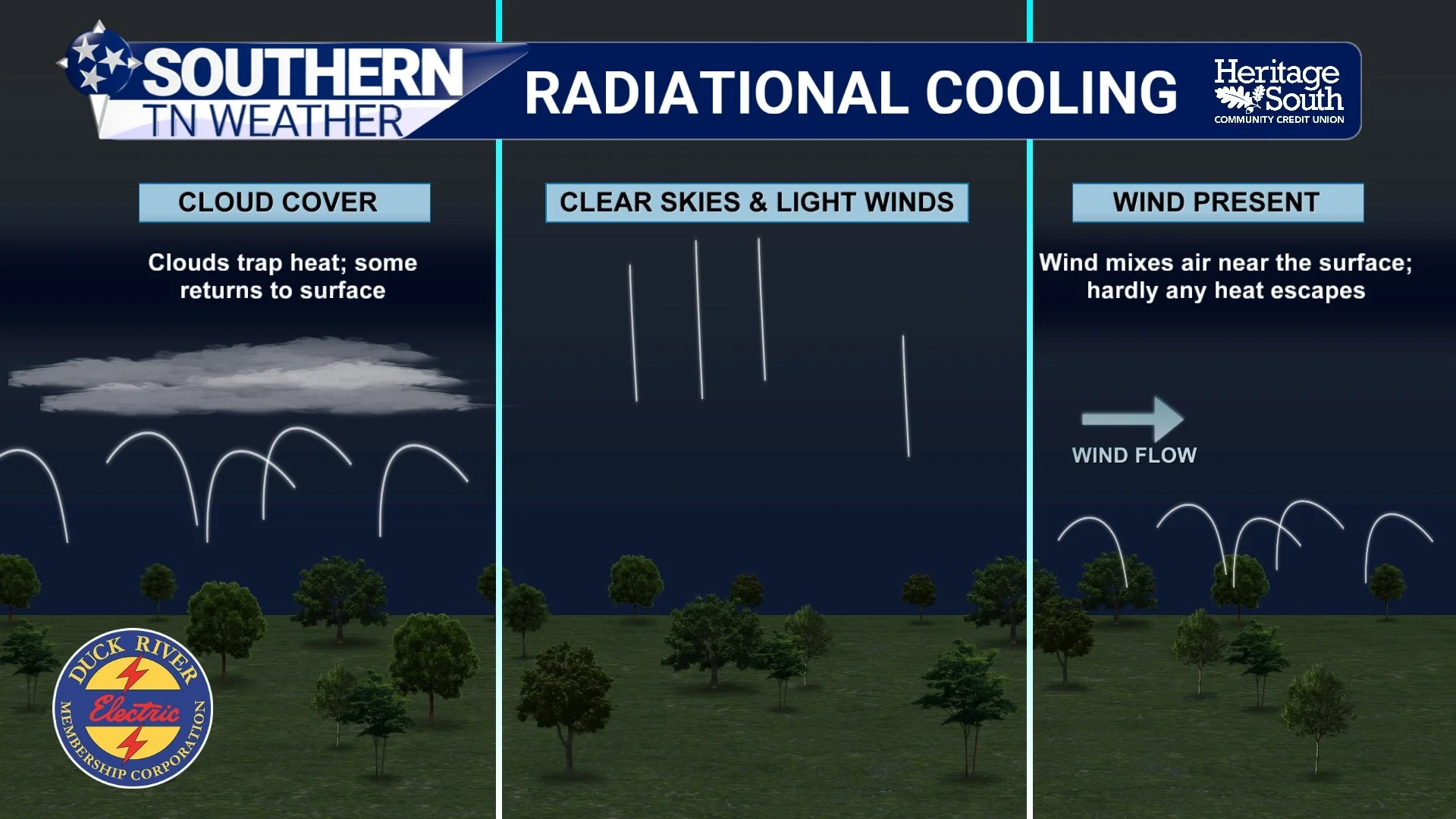
RADIATIONAL COOLING EXPLAINER
The Perfect Recipe for a Chilly Night
If we really want temperatures to tumble overnight, meteorologists typically look for a combination of clear skies, light winds and relatively dry air.
Wind makes a surprisingly large difference. On a calm night, the ground can cool rapidly and create a shallow layer of colder air immediately above the surface. When winds are stronger, the lower atmosphere remains better mixed. Slightly warmer air from above is continually mixed downward while colder air near the ground is mixed upward, making it harder for that very cold layer to develop right at the surface. That's why some of our coldest mornings occur when high pressure settles overhead and winds become nearly calm.
Humidity matters as well. Water vapor interacts strongly with infrared radiation, so relatively dry air generally allows for more efficient nighttime cooling than a very humid atmosphere, assuming the other ingredients are similar. That's especially relevant this week because the air settling into Southern Middle Tennessee isn't just cooler than what we've been dealing with lately, it's also considerably drier.
The length of the night matters, too. We just passed the fall equinox, which means nights are now becoming longer than days across the Northern Hemisphere. As we move deeper into fall, the Sun spends more time below the horizon, giving the surface a longer opportunity to lose energy before sunrise. This is one reason those crisp fall mornings can become surprisingly chilly even when the afternoons are still pleasantly warm.
Our terrain adds another interesting wrinkle across Southern Middle Tennessee. Cold air is denser than warm air, so during clear and calm nights it tends to settle downhill into valleys and other low-lying areas. This process, often called cold-air drainage, can create some pretty substantial temperature differences over surprisingly short distances. A sheltered valley could wake up to 51° while a nearby hilltop only falls to 57°, even though the two locations are separated by just a few miles.
The same process also contributes to the development of patchy valley fog. As that colder air collects in low-lying areas, temperatures can fall closer to the dew point until the air becomes saturated and tiny water droplets begin forming. That's one reason fog can be thick in a valley while conditions are perfectly clear just a short drive uphill.
Interestingly, clouds can have almost the exact opposite effect during the daytime. Instead of slowing the loss of energy, daytime clouds can prevent some solar energy from reaching the surface in the first place. They reflect a portion of incoming sunlight back toward space, limiting how quickly the ground can warm. That's why a thick overcast can keep an afternoon considerably cooler than expected, while those same clouds could keep the following night warmer.
So clouds essentially get to play both sides of the temperature game: they can help keep us cooler during the day and warmer at night.
We're About to Put Radiational Cooling to Work
This week's weather gives us a pretty good opportunity to watch some of this science happen in real life. Our long-awaited cold front has already pushed through, replacing the extreme heat of the past several weeks with a much cooler air mass. Low clouds behind the front have helped keep temperatures especially pleasant today, with highs generally in the upper 70s and lower 80s across much of the area. That's a pretty remarkable change considering some locations were flirting with 100° only a few days ago.
A few showers and thunderstorms will remain possible this afternoon, primarily across the Cumberland Plateau and our eastern areas. A couple of stronger storms could produce gusty winds, small hail and frequent lightning, but the overall severe-weather threat remains low. Another isolated shower may linger across our far eastern areas Thursday, but rain chances will quickly decrease as the upper-level system moves away and high pressure begins building into the region.
By Friday and through the weekend, that high pressure should give us increasingly clear skies, lower humidity and lighter winds. Combine those ingredients with the cooler and drier air mass already in place, and we have a pretty good setup for efficient radiational cooling after sunset.
Afternoon highs should generally remain in the lower to middle 80s, but once the Sun disappears, temperatures should fall pretty quickly. By this weekend, many communities across Southern Middle Tennessee could wake up to temperatures in the low to mid 50s. After dealing with afternoon temperatures in the upper 90s and Heat Index values of 105–110° just last week, walking outside to temperatures in the 50s is going to feel like somebody accidentally left the refrigerator door open.
Unfortunately for my fellow cool-weather fans, I wouldn't put the shorts into storage just yet. High pressure building across the Southeast should eventually allow temperatures to creep upward again early next week, with upper 80s and perhaps a few lower 90s returning by Tuesday. The good news is that we're not currently looking at another stretch of dangerous heat over the next seven days.
For now, I'm perfectly happy enjoying the open-window weather while we've got it.
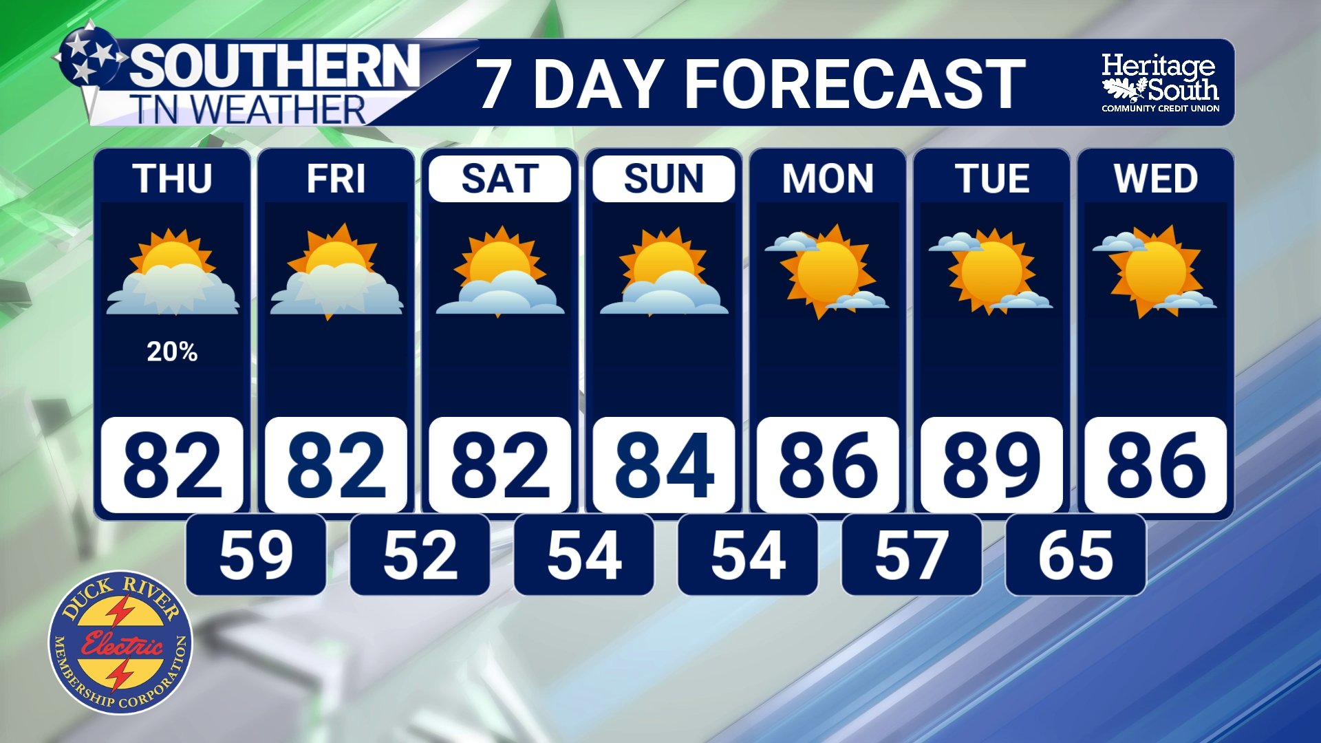
STNWX 7-DAY FORECAST
The Bottom Line 🧾
🍂 The autumnal equinox occurs at 7:05 PM CDT today, officially beginning astronomical fall in the Northern Hemisphere.
🌎 The equinox occurs when the Sun crosses the celestial equator from north to south.
☀️ Earth's 23.5° axial tilt is responsible for our seasons, not our distance from the Sun.
⚖️ Despite the name “equinox,” today does not feature exactly 12 hours of daylight and 12 hours of darkness.
🌅 The size of the Sun's disk and atmospheric refraction give us slightly more than 12 hours of daylight around the equinox.
📉 We're currently losing daylight quickly, and nights will become longer than days as we continue toward the winter solstice.
🌡️ The equinox does not directly cause cooler weather. Our conveniently timed cooldown is the result of a changing weather pattern and cooler air arriving behind our recent front.
⛈️ Scattered showers and storms remain possible today, with a few gusty storms possible.
🌦️ A few showers and storms may linger Wednesday, particularly farther east.
🍁 Highs settle into the lower to middle 80s later this week, with some upper 70s possible in the higher elevations.
🥶 Overnight lows drop into the 50s by Friday and this weekend, with some upper 40s possible on the Cumberland Plateau.
☀️ Mainly dry and VERY comfortable weather is expected Friday through the weekend.
📰 Reminder: The Southern Tennessee Weather Blog, presented by Heritage South Community Credit Union, is updated Monday through Friday with fresh, locally tailored forecasts you can trust.
