
Work Week Outlook: Dry Periods and Some Rain

The Southern Tennessee Weather Blog is proudly presented by Heritage South Community Credit Union.
We Help When Others Won’t!
Visit https://www.heritagesouth.org/ today to see how HSCCU can help YOU!
After the active weather we've dealt with over the past couple of weeks, Southern Middle Tennessee is finally getting a bit of a breather. Notice I said "breather" and not "dry spell."
The overall weather pattern this week is one of alternating quiet periods and passing disturbances. That means there will be plenty of opportunities to get outside and enjoy the weather, but we'll also have to keep an eye on a few rounds of showers and thunderstorms, especially during the latter half of the week. The good news? At least for now, I'm not seeing any widespread high-end severe weather setups.
A Beautiful Start To The Week
If you've stepped outside today, you've probably noticed the difference. Yesterday's cold front pushed through the area, bringing cooler and noticeably less humid air to Southern Middle Tennessee. Afternoon temperatures today will top out in the middle 70s to around 80 degrees under mostly sunny skies, which is actually several degrees below average for mid-June.
Tonight should be another comfortable one, with lows dropping into the upper 50s and lower 60s. It's a nice reminder that Tennessee can still offer some pleasant weather even in the middle of June.
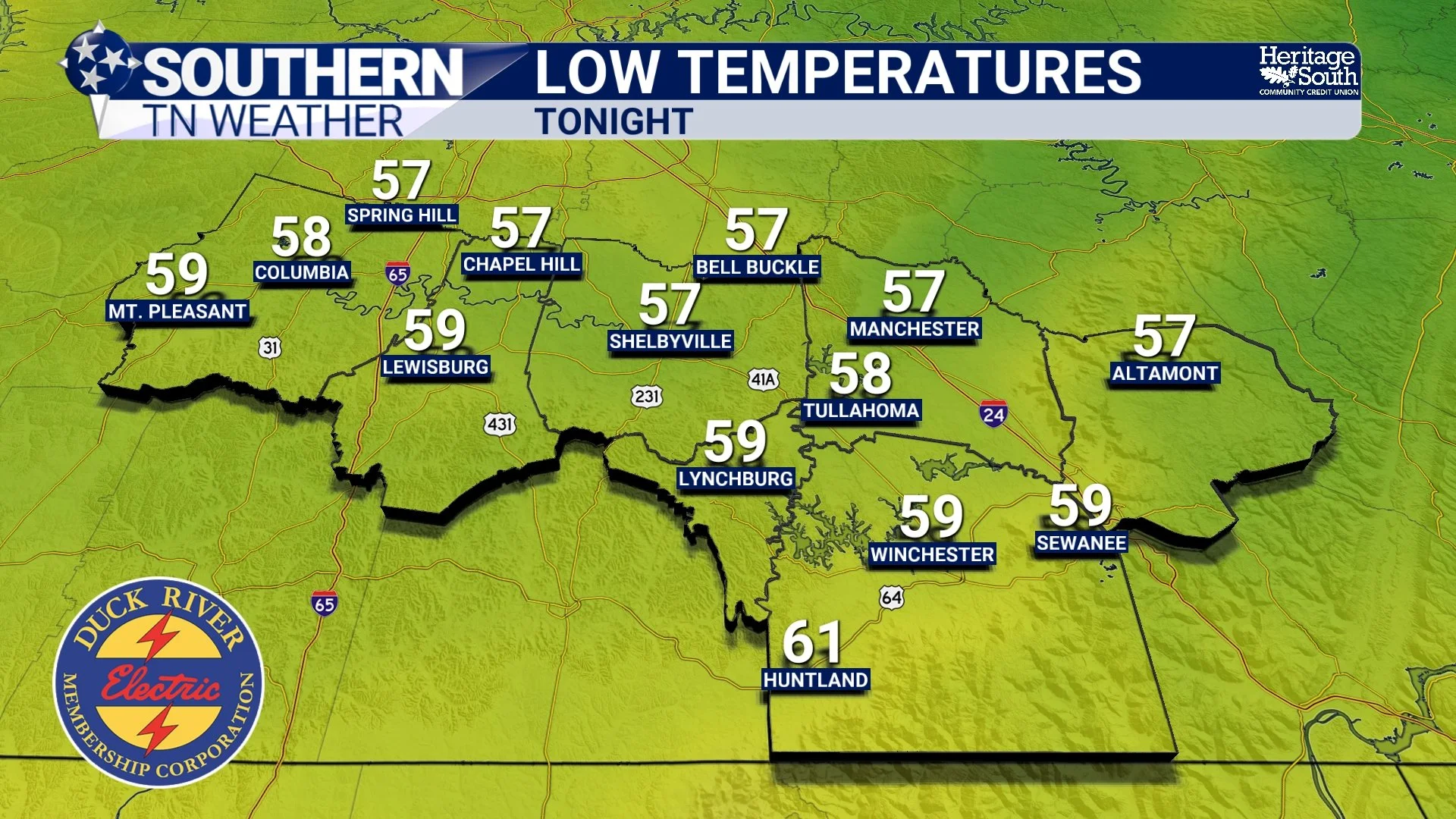
LOW TEMPERATURES - TONIGHT
Tuesday And Wednesday Stay Mostly Quiet
The quiet pattern continues into Tuesday, although temperatures will begin creeping upward as winds gradually shift back around to the south and southwest. Highs should climb into the lower and middle 80s Tuesday before reaching the upper 80s and perhaps touching 90 degrees by Wednesday afternoon.
Rain chances remain fairly limited during this time. There is a small chance for a stray shower or thunderstorm Tuesday evening, mainly north of Interstate 40. This would be associated with a weak disturbance tracking through the Great Lakes, but most of the associated rainfall should remain well to our north. For much of Southern Middle Tennessee, Tuesday and most of Wednesday look dry.
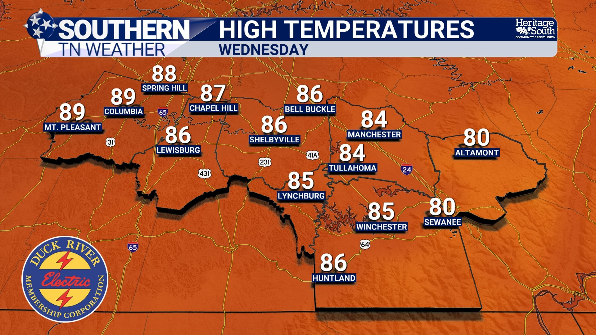
HIGH TEMPERATURES - WEDNESDAY
Thursday Is The Day To Watch
The weather pattern becomes much more active during the second half of the week. A cold front approaching from the northwest will gradually increase rain and thunderstorm chances beginning Wednesday night, but the greatest opportunity for widespread rainfall appears to arrive Thursday afternoon and continue into early Friday morning. The atmosphere will contain plenty of moisture by this point, with Gulf air returning to the region ahead of the front.
The encouraging news is that the ingredients for widespread severe weather don't appear to be coming together particularly well. The strongest upper-level winds remain displaced to our north, and forecast soundings suggest a fairly saturated atmosphere. That doesn't mean thunderstorms can't become strong. A few storms could produce gusty winds and very heavy rainfall, but at this point the overall severe weather threat appears fairly low.
Heavy rainfall may ultimately become the bigger concern, especially if thunderstorms repeatedly move across the same locations.
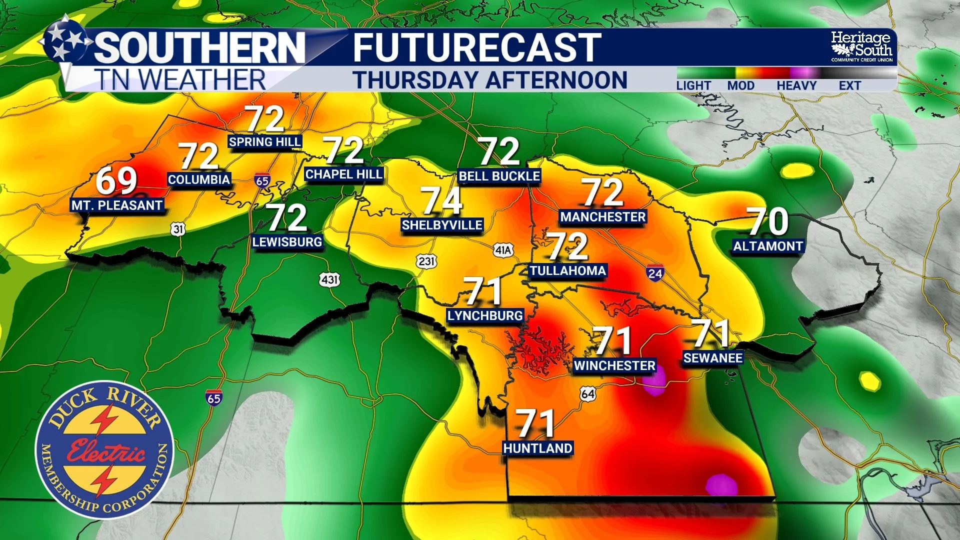
FUTURECAST - THURSDAY AFTERNOON
FridAY EVENING BRINGS IMPROVEMENT
As the cold front gradually pushes through the area, rain and thunderstorm chances should decrease from northwest to southeast during the day Friday. There may still be a few lingering showers during the evening, but conditions should gradually improve as we head into the overnight hours. Of course, this will depend on the exact timing of the cold front, which we don’t have any idea of knowing this far in advance.
Temperatures will also begin trending downward behind the front.
The First Weekend Forecast
If you're already making weekend plans, Saturday is shaping up to be the nicer of the two days. Cooler and drier air should settle across Southern Middle Tennessee, bringing highs in the upper 70s to middle 80s along with noticeably lower humidity levels.
Sunday becomes a bit more uncertain. Another weather system may begin approaching from the west, bringing another opportunity for scattered showers and thunderstorms back into the forecast. At this point, rain chances appear lower than Thursday's system, but they're certainly worth keeping an eye on if you have outdoor plans.
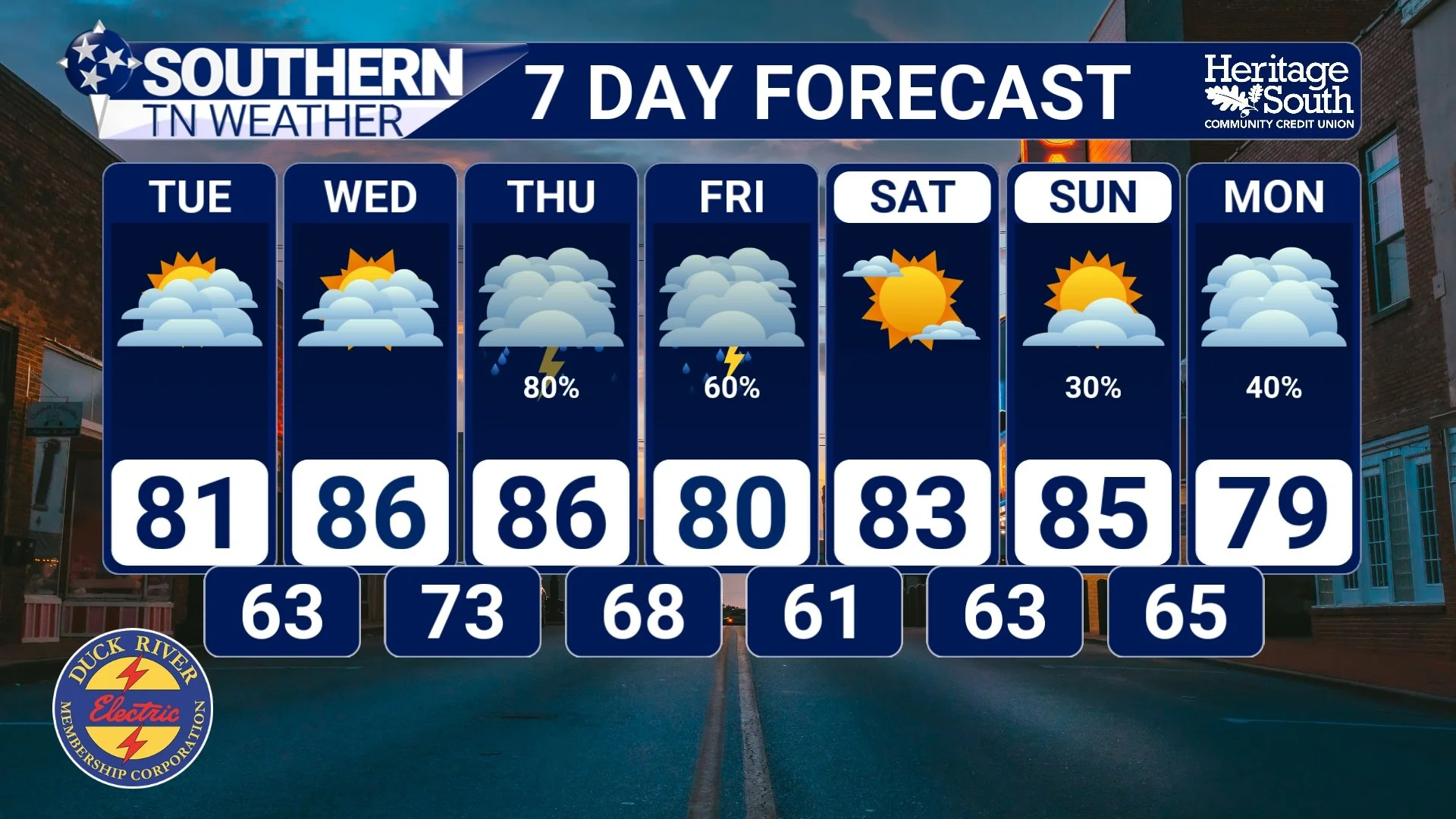
STNWX 7-DAY FORECAST
The Bottom Line 🧾
Beautiful weather continues today with highs in the 70s to near 80.
Tuesday and most of Wednesday look mainly dry.
Rain and thunderstorm chances increase Wednesday night.
Thursday into early Friday brings the best chance for widespread rainfall.
A few stronger storms are possible, but the overall severe weather threat remains low.
Saturday looks cooler, drier, and pleasant.
Rain chances return later Sunday and into early next week.
📰 Reminder: The Southern Tennessee Weather Blog, presented by Heritage South Community Credit Union, is updated Monday through Friday with fresh, locally tailored forecasts you can trust.