
How Will Arthur Impact Us? Here's What To Expect Locally

The Southern Tennessee Weather Blog is proudly presented by Heritage South Community Credit Union.
We Help When Others Won’t!
Visit https://www.heritagesouth.org/ today to see how HSCCU can help YOU!
Whenever a tropical system develops in the Gulf, one of the first questions I get is simple: "Is it coming here?"
The short answer with Arthur is no. The center of the storm is expected to stay well to our south as it moves inland along the Gulf Coast and eventually weakens. Southern Middle Tennessee won't experience tropical storm conditions, storm surge, or anything close to what some on the Gulf Coast will see. But that doesn't mean Arthur won't impact our weather.
In fact, this week's forecast features a somewhat unusual setup where tropical moisture from Arthur will interact with a cold front approaching from the northwest. The result? A messy forecast with increasing humidity, widespread rain chances, and the potential for some heavy downpours across our area.
Enjoy The Quiet Weather While It Lasts
The good news is that we still have a little time before the active weather arrives. Tuesday afternoon and much of Wednesday look quite pleasant by June standards. Highs today will stay in the upper 70s and lower 80s with relatively comfortable humidity levels. By Wednesday, temperatures will climb back into the upper 80s as southerly winds begin transporting warmer, more humid air back into the region.
You'll probably notice the difference by Wednesday afternoon. Dewpoints will climb into the upper 60s and lower 70s, making it feel considerably more muggy than the past few days. That's our first hint that tropical moisture is beginning to arrive.
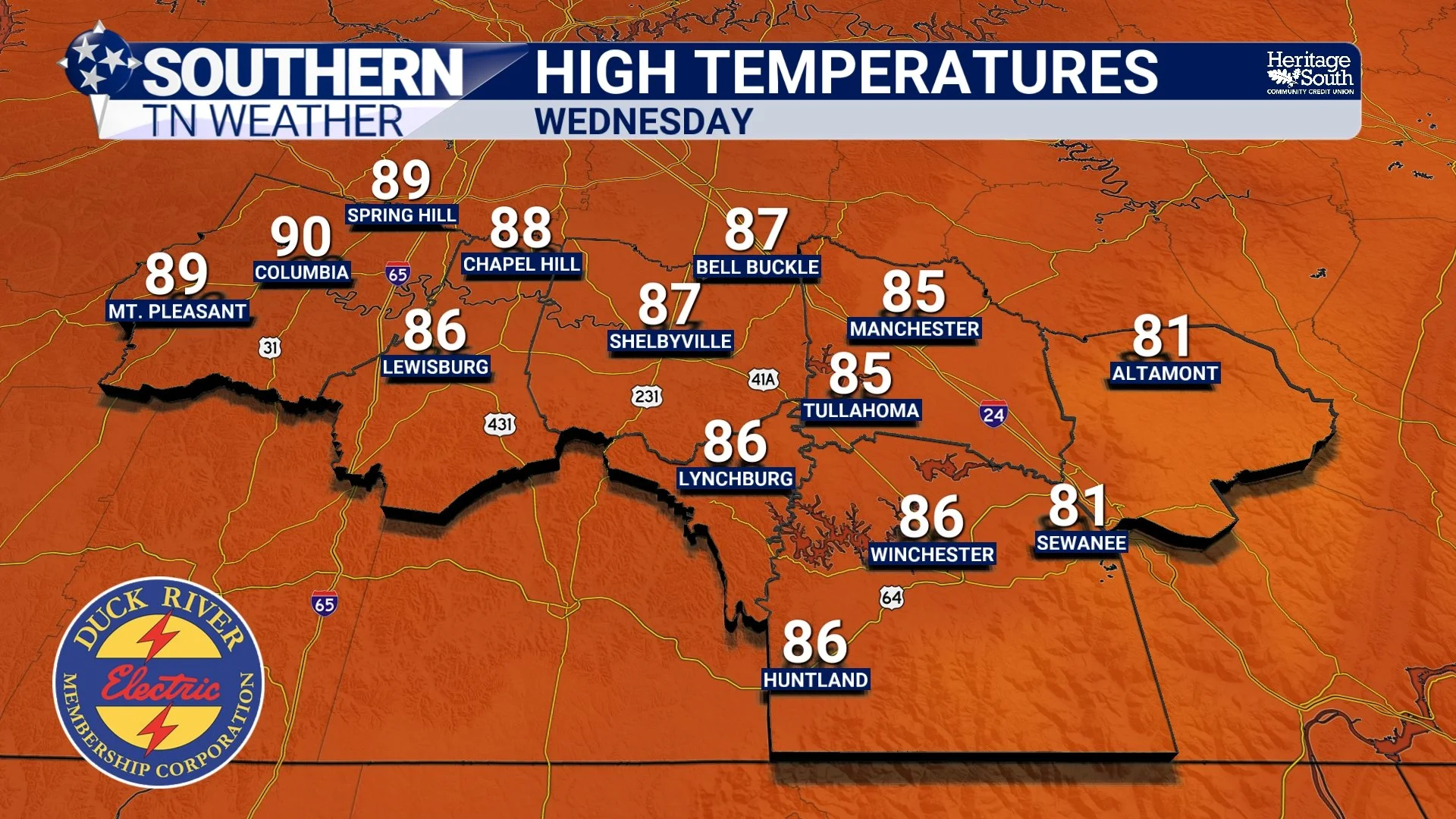
HIGH TEMPERATURES - WEDNESDAY
Arthur Doesn't Have To Hit Tennessee To Affect Tennessee
One common misconception is that a tropical system has to move directly overhead to influence our weather. That's simply not true. Tropical systems act like giant moisture pumps, transporting enormous amounts of Gulf moisture northward. This week, southwesterly winds ahead of an approaching cold front will help pull some of that tropical air into the area.
Meteorologists often measure atmospheric moisture using something called precipitable water, or PWAT. Think of it as a measurement of how much water vapor is available in the atmosphere. By Thursday and Friday, PWAT values across our area could approach two inches, which is well above normal for this time of year and near the 90th percentile climatologically. In simple terms, the atmosphere will be loaded with moisture.
Then Comes The Cold Front
If Arthur were the only player involved, we'd probably just deal with periods of rain. But there's another ingredient entering the picture. A cold front will approach Southern Middle Tennessee from the northwest during the day Thursday and move through the area into Friday.
Cold fronts provide lift. Tropical air provides moisture. Put those two ingredients together, and you create an environment favorable for widespread showers and thunderstorms. The exact timing remains somewhat uncertain, but Thursday afternoon through Friday morning appears to be the most active period.
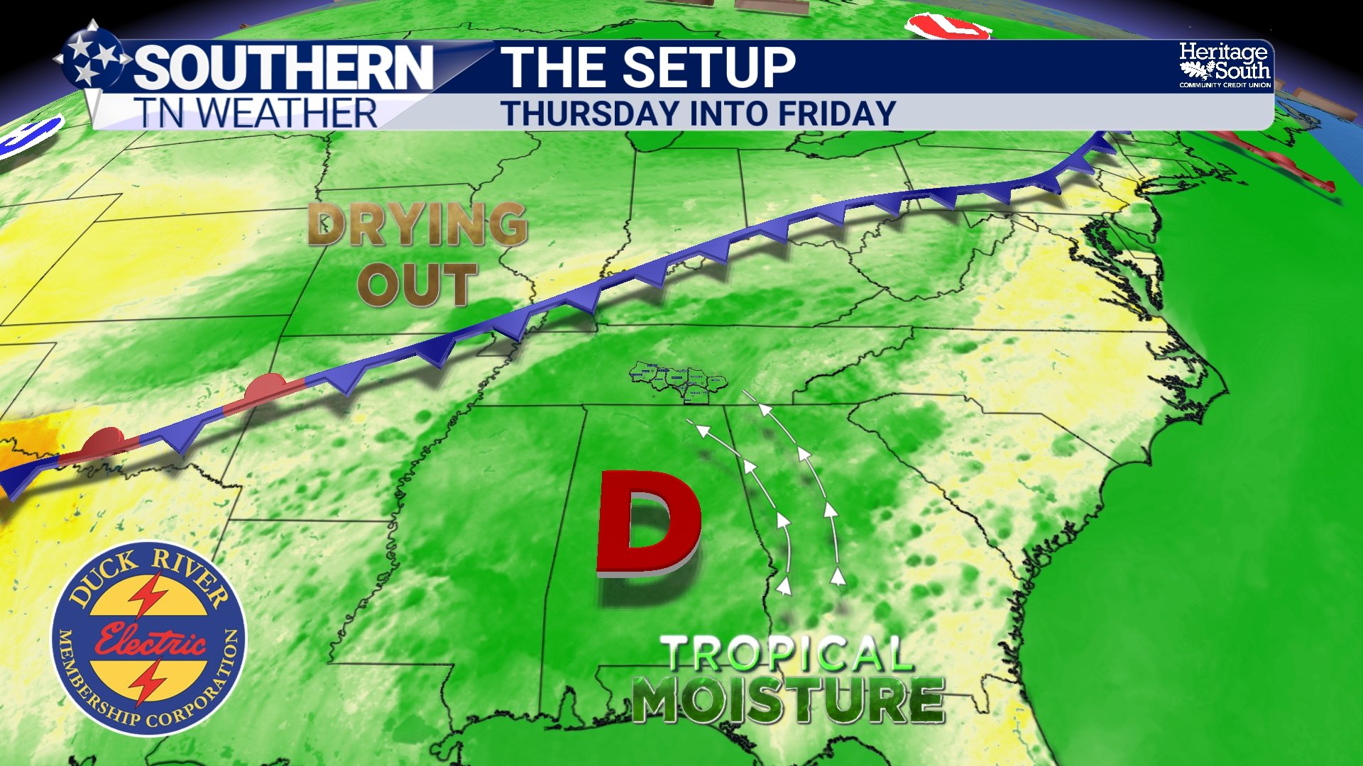
THE SETUP - WEDNESDAY INTO THURSDAY
What's The Biggest Threat?
At this point, I'm more concerned about heavy rainfall than severe weather. The atmosphere will contain abundant moisture, meaning any thunderstorm that develops could produce very efficient rainfall. While current projections suggest the heaviest totals may remain to our south, there is certainly the potential for localized flooding if storms repeatedly move across the same locations.
That doesn't mean severe weather is off the table. A few stronger storms capable of producing gusty winds could develop Thursday afternoon and evening. The overall severe weather threat appears relatively low, however, since the strongest upper-level winds and wind shear will remain displaced well to our north. A MARGINAL risk (level 1/5) is in place from the Storm Prediction Center.
Interestingly, tropical systems can sometimes locally enhance wind shear. While that could create an isolated tornado threat in parts of the Southeast closer to Arthur's center of circulation, that risk appears QUITE LIMITED across Southern Middle Tennessee.
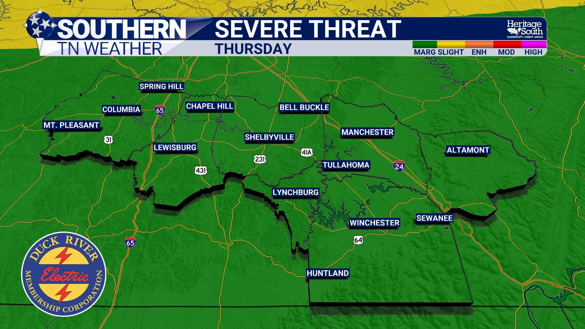
SEVERE THREAT - THURSDAY
Friday Stays Wet Before Improvements Arrive
Rain chances will likely continue into Friday ahead of the departing cold front. Exactly how much rain we receive will depend on two things: how quickly the front moves through and how closely the remnants of Arthur track to our south. Current guidance suggests Southern Middle Tennessee may avoid the highest rainfall totals, but this is a forecast I'll be watching closely over the next couple of days. Right now, widespread totals up to 1 inch look likely, with a few areas seeing less than that while others see more. Pretty typical for this time of year.
The good news is that the front eventually wins. By Friday afternoon and evening, showers and storms should gradually move out of the area.
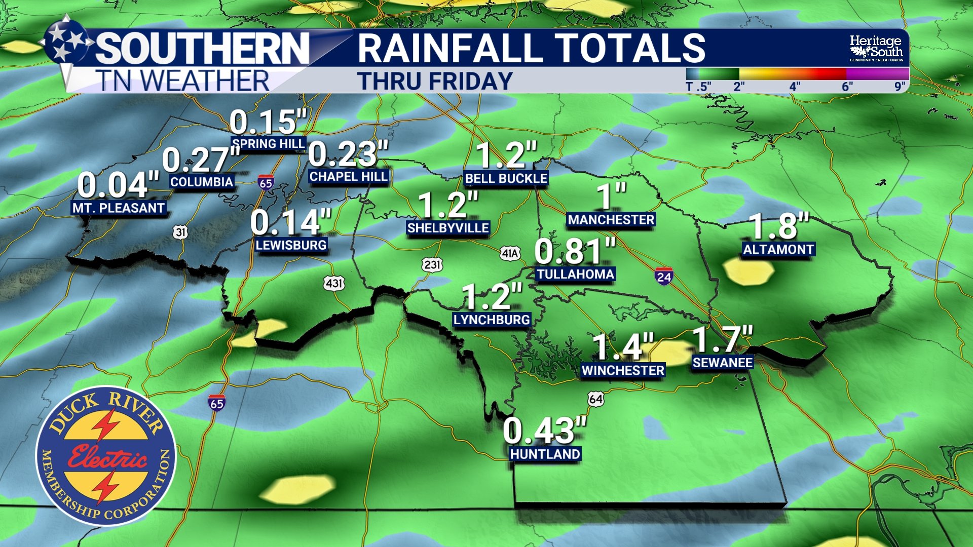
RAINFALL TOTALS - THRU FRIDAY
The Weekend Looks Fantastic
After several active days, Saturday is shaping up to be the reward. Cooler, drier air should filter into Southern Middle Tennessee behind the cold front, bringing lower humidity, comfortable temperatures, and plenty of sunshine. Of course, this is June in Tennessee, so the quiet weather probably won't last forever.
Additional disturbances could bring rain chances back into the forecast later Sunday and early next week. But after dealing with tropical moisture and a passing cold front, I think we'll gladly take a nice Saturday.
The Bottom Line 🧾
Arthur will stay well south of Tennessee but will still influence our weather.
Tropical moisture from Arthur will increase humidity Wednesday and Thursday.
A cold front approaching from the northwest will interact with that moisture.
Showers and thunderstorms become likely Thursday into Friday.
Heavy rainfall is the primary concern, with localized flooding possible.
A few stronger storms with gusty winds can't be ruled out.
Storms should gradually exit Friday evening.
Saturday is shaping up to be a beautiful day across Southern Middle Tennessee
📰 Reminder: The Southern Tennessee Weather Blog, presented by Heritage South Community Credit Union, is updated Monday through Friday with fresh, locally tailored forecasts you can trust.