
A Winter Storm Is Taking Shape… But Details Are Still Murky

The Southern Tennessee Weather Blog is proudly presented by Heritage South Community Credit Union.
We Help When Others Won’t!
Visit https://www.heritagesouth.org/ today to see how HSCCU can help YOU!
If you’ve lived in Tennessee long enough, you know winter storms rarely arrive cleanly. They don’t usually give us textbook snow setups. They bend. They wobble. They introduce last-minute complications. That’s exactly what we’re watching unfold now. Confidence continues to increase that a major winter storm will impact parts of the South this weekend. That part of the forecast is becoming solid. What is becoming less solid is how that storm behaves once it reaches Tennessee.
Over the past 24 hours, forecast models have nudged the developing storm system farther north. That might sound like a small change, but in winter forecasting, it’s a big one. A farther-north track allows warm air to creep in above the surface, opening the door to sleet, freezing rain, and even periods of cold rain instead of a straightforward snowstorm. And that is why you haven’t seen snow totals from me yet. Anyone posting 12–24 inch snowfall maps for us right now is skipping the part of the process that usually matters most in Tennessee: temperature profiles.
So for Southern Middle Tennessee, the conversation has officially changed. This is no longer about if winter weather happens. It’s about what type, how much, and where the worst impacts set up. Now is the time to prepare. Tomorrow is when we should begin to responsibly talk about numbers.
Today and Tonight: Mild Before the Real Setup Begins
Cloud cover has continued to increase today ahead of a weak, fast-moving disturbance. Southerly winds have pushed temperatures into the 40s and low 50s, and scattered light rain showers will continue at times this afternoon and evening. This system is moisture-limited and dynamically weak. It is not a winter weather concern. Precipitation will remain all liquid, and impacts will be minimal.
Behind tonight’s showers, surface high pressure briefly builds in on Thursday. Thursday will actually be one of the better days we see for a while — mainly dry, relatively seasonable, and a critical window to finalize preparations. Once we move into Friday (especially Friday night) the pattern changes rapidly.
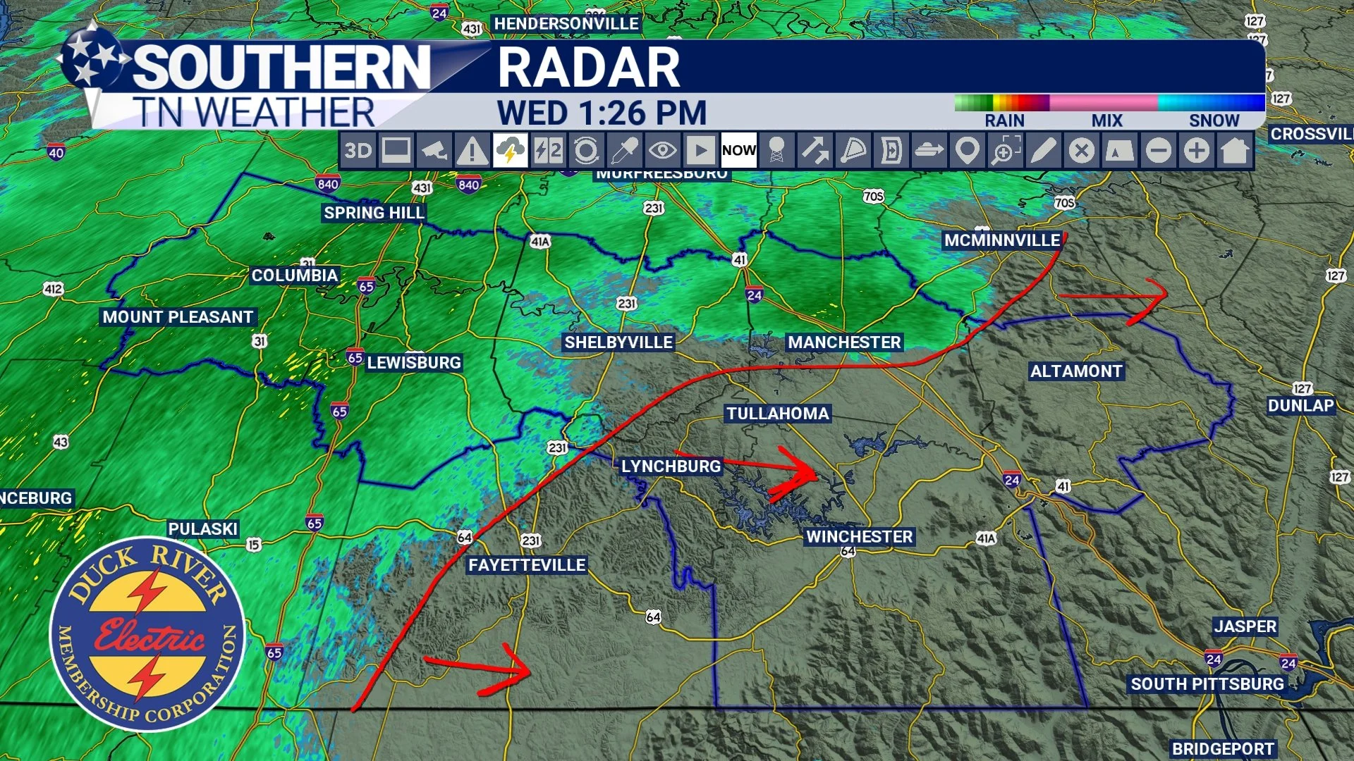
STNWX Radar - Wednesday Afternoon
The Overall Setup
By Friday, a strong Arctic high will be pressing southward into the Tennessee Valley. This high will not be shallow. It will be deep, dense, and capable of holding surface temperatures at or below freezing for an extended period. At the same time, a southern-stream upper low will organize across the Southwest and eject eastward. Ahead of it, strong southwesterly flow will transport anomalously high Gulf moisture across the southern Plains and into the Southeast.
This is one of the most efficient large-scale winter storm patterns you can have in the southern U.S.: deep cold air already in place, strong moisture overrunning that cold dome, increasing upper-level forcing, and the potential for interaction with northern-stream energy. The Weather Prediction Center now states it is almost certain that a significant winter storm will occur across the southern tier of the U.S. this weekend. Their concern explicitly includes both heavy snow and significant icing. That wording is not used casually.
What This Means for Southern Middle Tennessee
For our area, the environment is increasingly supportive of high-impact winter weather Friday night through Sunday. The biggest forecast challenge is no longer storm development. The challenge is precipitation type. Current data continues to suggest a colder, snow-favored environment north of I-40, with a much more complicated temperature profile south of I-40, where sleet and freezing rain become increasingly possible.
Over the last several model cycles, guidance has introduced a stronger warm layer aloft (warm nose) pushing northward during the peak of the event. This is not a small change. That warm nose is what separates a snowstorm from an ice storm. The American guidance tends to keep us colder, supporting a mix of snow, sleet, and freezing rain. The European and several other guidance suites are warmer aloft, especially late Saturday into Sunday, which would introduce more sleet, freezing rain, and even periods of cold rain — especially in our southeastern areas. Based on how Tennessee winter storms usually evolve, this warmer scenario cannot be ignored.
Any period of plain rain would limit ice buildup on trees and power lines, but it would not eliminate impacts. With Arctic air quickly re-establishing itself, anything wet would freeze again as temperatures crash Sunday night. That introduces a whole new set of hazards with black ice.
The further we go forward in time, the more my concern shifts toward ice potential for Southern Middle Tennessee. This is not a good trend. Ice storms are far more disruptive than snowstorms in our region. The presence of a persistent warm nose in several guidance suites shifts this from a “just snow” event into a multi-hazard winter storm. I never once stated this was going to be an all-snow storm. And it’s coming back to bite the people that did.
My current thinking is that we will have a warm nose push into Middle Tennessee. The best chance for any precipitation to change over to liquid rain (meaning surface temps above 32 degrees) will be generally along and south/east of TN-64. See the map below for more on this. I’ve also included a graphic showing precip types and how the warm nose impacts what type of precipitation we see. Razor thin margins. That is what we’re dealing with here. Just how far north the plain rain makes it still needs to be figured out… So stay tuned for updates. EITHER WAY, with plain rain or without, this system will likely start out with all frozen precip for our area late Friday night into Saturday morning.
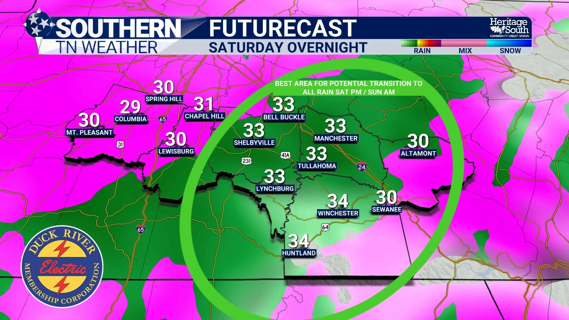
Potential for some normal rain…?
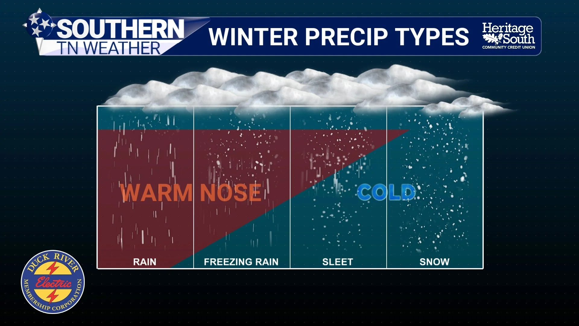
Warm Nose Info
Timing and Evolution
At a broad level, the current consensus window remains:
• Friday: Arctic air entrenches, precipitation approaches
• Friday night into Saturday: Widespread winter precipitation develops
• Saturday into Sunday: Prolonged winter storm with varying precipitation types (potentially some liquid rain too)
• Sunday evening: Gradual tapering west to east with a deep freeze taking hold
• Early next week: Bitter cold prolongs impacts
Temperatures are expected to remain at or below freezing for extended periods. That means whatever falls will not quickly melt, and impacts would linger.
The Cold Is a Hazard by Itself
Behind the system, Arctic air deepens further. Current guidance supports teens for many locations, single digits possible, and wind chills near or below zero. Many areas may remain below freezing well into next week.
If winter precipitation occurs (especially ice) those temperatures dramatically increase the risk of prolonged travel problems, refreeze, power issues, and slow recovery.
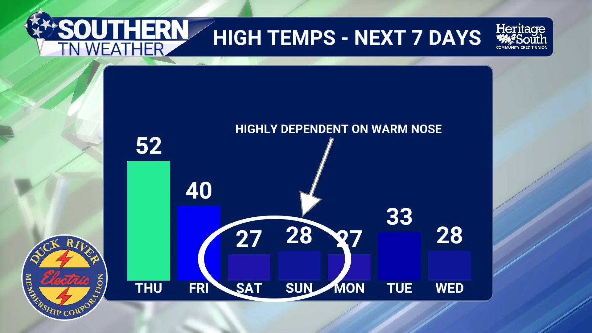
High Temps - Next 7 Days
What We Know, and What We Are Still Solving
We are confident that a major winter storm will occur across the South and that Southern Middle Tennessee is within the impact zone. We are confident travel impacts are likely. What remains highly uncertain is exactly how this storm expresses itself here: snow versus sleet versus freezing rain versus periods of cold rain, storm track nuances, the strength of the warm nose, and where the most significant ice risk ultimately sets up.
Those are not minor details, but rather the entire forecast. And they are the pieces that typically do not resolve cleanly until inside 48 hours. Tomorrow is when we should begin to have enough resolution in the data to talk about specific accumulation ranges… not today. Regardless of the chance for normal rain or not, everyone needs to be preparing for a potentially impactful winter storm.
The Bottom Line 🧾
• A major winter storm is increasingly likely this weekend
• Southern Middle Tennessee remains in the impact zone
• Wednesday’s rain is not the event
• Precipitation type is the biggest uncertainty for this weekend
• Ice potential is increasing
• Dangerous cold will prolong impacts
• Accumulation forecasts should begin coming into focus tomorrow
📰 Reminder: The Southern Tennessee Weather Blog (Presented by Heritage South Community Credit Union) is updated Monday through Friday with fresh, locally tailored forecasts you can trust