
Winter Storm Alerts Issued: A High-Impact Weekend Is Ahead

The Southern Tennessee Weather Blog is proudly presented by Heritage South Community Credit Union.
We Help When Others Won’t!
Visit https://www.heritagesouth.org/ today to see how HSCCU can help YOU!
Southern Middle Tennessee is now within the high-confidence zone for a significant winter storm this weekend. After several days of watching trends and refining the pattern, we’ve reached the point where confidence is no longer in whether winter weather occurs but rather how it unfolds and where the greatest impacts ultimately set up.
National Weather Service offices across the region have now issued Winter Storm Warnings, Winter Weather Advisories, and Ice Storm Warnings. This reflects the growing concern for dangerous travel, significant icing in some areas, and prolonged impacts that may last well into next week.
Today and Friday will serve as the final preparation window.
Today and Friday: The Calm Before the Storm
Today has turned out to be the nicest day we will see for a while. Sunshine, dry weather, and seasonable temperatures are in place across Southern Middle Tennessee. Any remaining fog and low clouds have cleared, and conditions are favorable for outdoor preparations.
Friday will remain dry through the daytime hours, but changes will already be underway behind the scenes. An Arctic front will press south into the region late Friday, ushering in much colder air and setting the stage for winter precipitation. If you have errands to run, supplies to gather, or plans to adjust — today and Friday are the time to do it.
When Does It Start?
Moisture will begin advancing out of the southern Plains late Friday night. Current guidance continues to point toward precipitation arriving between midnight and 6 AM Saturday, first across western portions of Southern Middle Tennessee, then spreading east. Temperatures at onset will already be in the teens and lower 20s. That means whatever falls will quickly stick.
Initial precipitation types are expected to include snow and sleet, quickly transitioning into a more complex mix as warmer air moves in aloft. Travel conditions are expected to deteriorate rapidly early Saturday morning.
The Core of the Storm: Why This Is a High-Impact Setup
This system is the product of two powerful ingredients coming together:
A deep Arctic air mass pressing southward into the Tennessee Valley and a southern-stream storm system transporting Gulf moisture northeastward over the top of that cold air. This is a classic southern winter storm configuration — and one that very often produces snow, sleet, freezing rain, and prolonged impacts.
As the day Saturday progresses, models consistently show a warm nose developing aloft. This does not warm the surface. Instead, it melts snowflakes as they fall, allowing them to refreeze into sleet or become supercooled droplets that freeze on contact. That is how ice storms are born.
The position and strength of that warm nose will determine where heavy snow occurs, where sleet dominates, and where freezing rain becomes the main threat. And that’s where the forecast remains most sensitive.
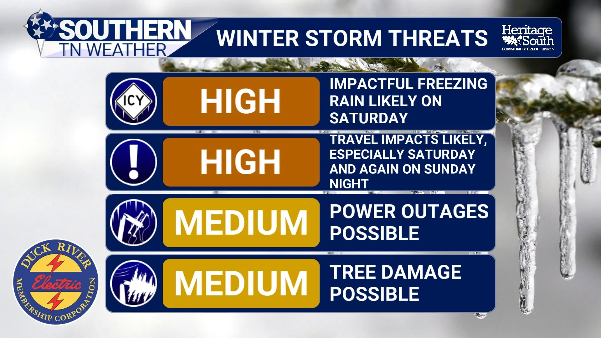
Storm Threats - This Weekend
WHO IS MOST AT RISK FOR ICE / ACCUMULATIONS
At this time, forecast guidance continues to support a northwest-to-southeast gradient in precipitation type across Southern Middle Tennessee. In other words, the farther northwest you go, the colder the profile looks to remain. The farther southeast you go, the greater the chance of warmer air intruding aloft — which increases the risk for complex mixed precipitation and potentially even some plain rain. Based on the latest data and my current forecast thinking, here is how the risk is shaping up:
Areas along and west of Interstate 65 currently appear most likely to remain below freezing for the longest period while precipitation is ongoing. This zone carries the highest concern for damaging ice, with one-quarter to one-half inch of ice accumulation possible. Little to no time above freezing is currently expected in this area.
Across our central counties, confidence is lower due to an increasing signal for a possible transition to plain rain late Saturday night into Sunday. However, one-tenth to one-quarter inch of ice may occur before any changeover. Even these lower totals are more than sufficient to create dangerous travel and scattered infrastructure issues.
Farther south and east (including Grundy, Franklin, and eastern Coffee Counties) guidance increasingly supports a transition to above-freezing temperatures and plain rain late Saturday night into Sunday. Because of that, ice totals appear lower, but up to one-tenth inch of ice remains possible before any changeover occurs.
Winter headlines now reflect this evolving threat:
Ice Storm Warnings are in effect where confidence is highest in damaging ice potential.
Winter Storm Warnings cover areas where a combination of heavy snow, sleet, and ice is possible.
Winter Weather Advisories highlight areas with lower expected totals, but still hazardous impacts.
As the storm evolves Saturday into Saturday night, some southern and eastern areas may indeed transition to plain rain. While that could limit additional ice accumulation, it introduces a new concern: refreezing. Once colder air rushes back in late Sunday, any standing water will freeze, potentially leading to widespread black ice and renewed travel hazards even after precipitation ends.
And it is very important to say this clearly:
This forecast can (and will) change between now and the onset of the storm. We are still refining where the rain/ice/snow lines ultimately set up. Small shifts will matter.
That is why daily updates (and eventually nowcasting) will be critical with this event. Usually, widespread travel impacts occur at a tenth of an inch of ice or greater. Power issues generally above a quarter inch. Hopefully that puts this forecast into perspective for you.
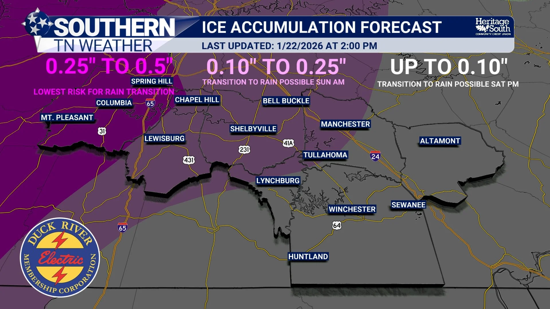
Ice Accumulation Forecast
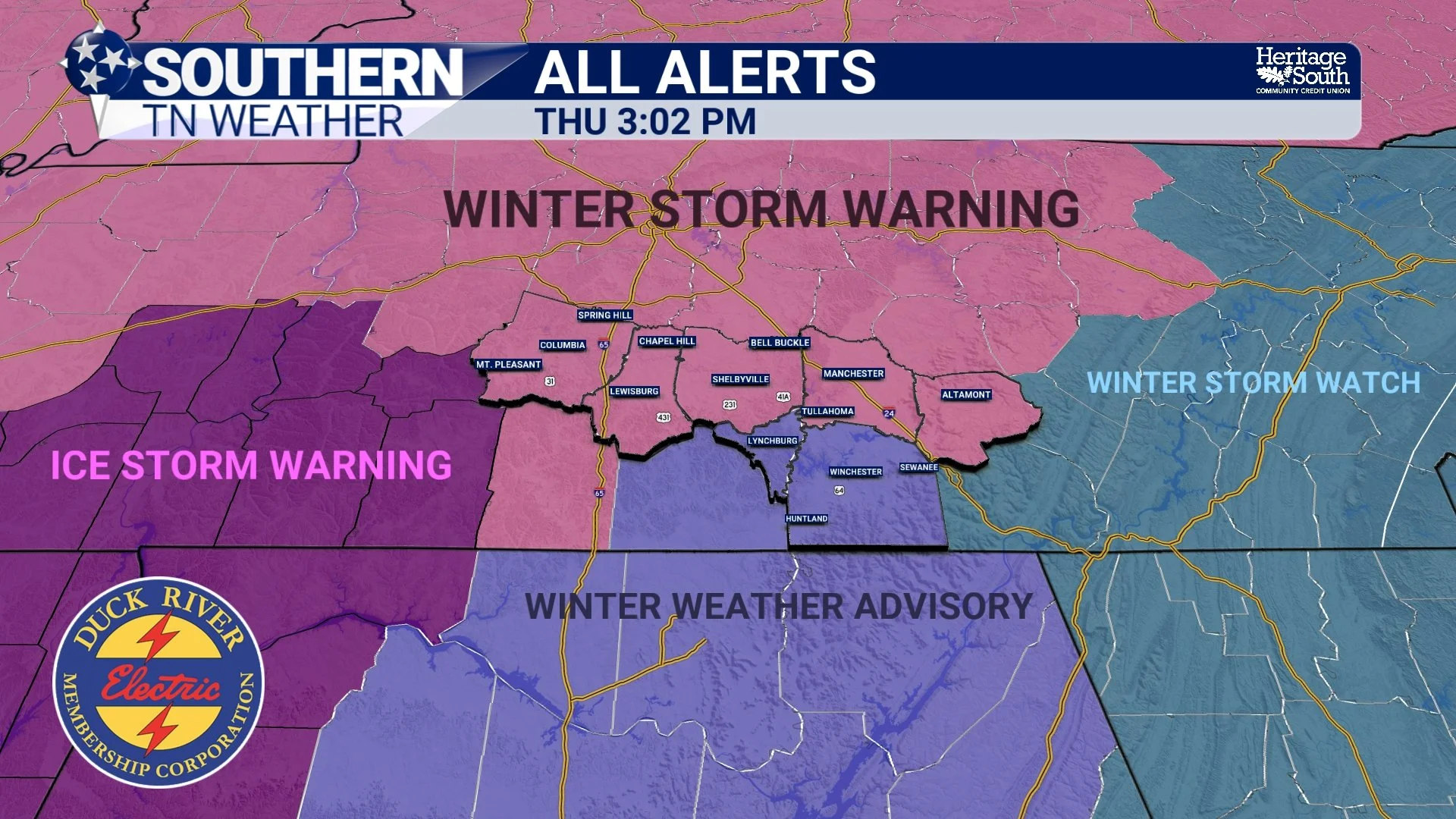
Warning Map
Sunday and Beyond: The Cold Locks In
As the surface low lifts northeast Sunday afternoon, winds will turn back to the northwest. That will scour out any lingering warm air aloft, allowing colder air to deepen once again. On the back side of the storm, precipitation may briefly end as snow before tapering off. What follows may be just as impactful as what falls.
Arctic air will surge back into the region Sunday night. Temperatures are expected to plunge into the single digits, with some areas possibly even colder. Highs Monday may struggle through the 20s, and refreezing will occur every night. That means impacts could persist well into early next week, even after precipitation ends.
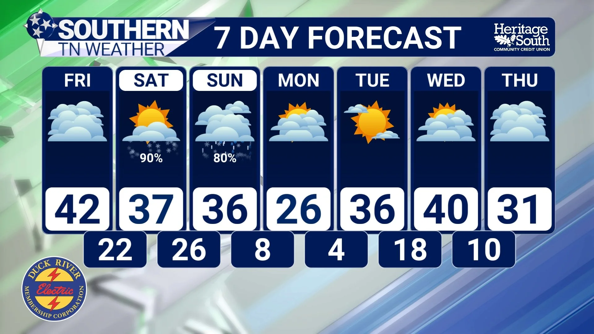
STNWX - 7 Day Forecast
What We’re Still Refining
We are now in the phase where forecast confidence is high in impacts, but moderate in details.
We continue to refine:
• Where the greatest ice accumulations occur
• How long freezing rain persists before any changeover to rain
• Which counties experience the worst impacts
Those details will continue to sharpen as higher-resolution guidance resolves the storm’s internal structure.
The Bottom Line 🧾
• Winter Storm Warnings, Winter Weather Advisories, and Ice Storm Warnings are now in effect
• Hazardous travel is likely beginning early Saturday
• Snow, sleet, and freezing rain are all expected in the region
• Damaging ice is most concerning across our northwestern zones
• Some areas may change to rain Saturday night into Sunday, then refreeze
• Very cold air will prolong impacts into early next week
• Today and Friday are the final preparation window
📰 Reminder: The Southern Tennessee Weather Blog (Presented by Heritage South Community Credit Union) is updated Monday through Friday with fresh, locally tailored forecasts you can trust