
Confidence Growing in a High-Impact Winter Storm This Weekend

The Southern Tennessee Weather Blog is proudly presented by Heritage South Community Credit Union.
We Help When Others Won’t!
Visit https://www.heritagesouth.org/ today to see how HSCCU can help YOU!
Southern Middle Tennessee remains firmly embedded in a cold-season pattern, but the focus is now shifting from cold air to an increasingly organized winter storm threat late this week into the weekend.
While a weak system will bring scattered rain showers Wednesday into Wednesday night, confidence is growing that a much more impactful system will affect parts of the South Friday through Sunday. Forecast guidance from the National Weather Service, the Weather Prediction Center, and multiple ensemble systems is converging on a classic southern-stream winter storm setup — one capable of producing widespread snow and ice across the southern tier of the United States.
Its not a matter of IF Southern Middle Tennessee gets snow and ice. It’s a matter of how much at this point in the forecast. This is no longer just “model watching.” The large-scale pieces are coming together.
Today and Tonight: Cold, but Slowly Moderating
High pressure remains centered over the region today, following this morning’s frigid start. Temperatures have been recovering through the 20s and into the 30s this afternoon with plenty of sunshine. Winds are light, and conditions remain quiet.
As the surface high shifts east this evening, low-level winds will begin turning southerly. That return flow will prevent another extreme drop tonight, but it will still be cold. Overnight lows are expected to fall into the 20s across Southern Middle Tennessee.
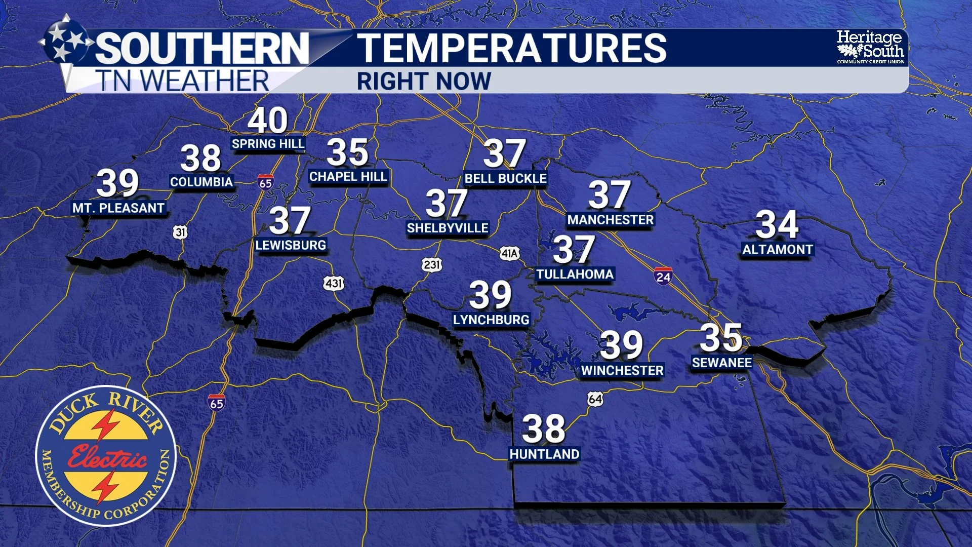
Temps - This Afternoon
Wednesday: Clouds Increase, Scattered Rain Returns
Wednesday brings a weak, fast-moving disturbance and a weak surface front. Southerly flow ahead of the system will increase moisture, leading to medium to high chances of scattered rain showers developing by late morning and continuing into Wednesday night. Timing looks to be mostly between 11:00 AM Wednesday and 3:00 AM Thursday. It will NOT rain during this entire timeframe.
This system is not dynamically strong and is limited in available moisture. Rainfall amounts look light overall, and instability is lacking. At this time, temperatures are expected to remain warm enough for precipitation to stay as rain. While a brief mix with snow on the Cumberland Plateau Wednesday night cannot be fully ruled out, guidance continues to indicate little to no impact from this midweek system.
Wednesday is important not for what it produces, but for what follows.
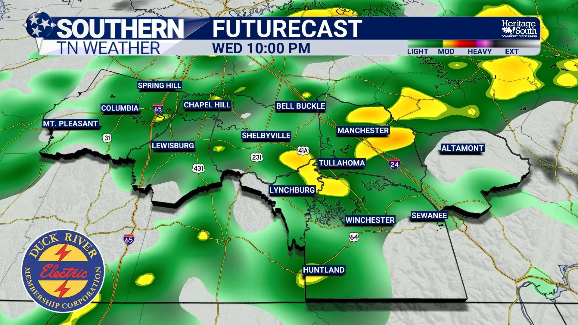
Rain - Wednesday night
The Pattern Shift: Why Confidence Is Increasing
Behind Wednesday’s system, surface high pressure will again build southeastward. By Friday, a reinforcing Arctic air mass will settle into the Tennessee Valley. That cold air will not be shallow. It will be deep, dense, and well-established. At the same time, the upper-air pattern becomes much more favorable for a significant southern-stream storm system.
An upper-level trough is forecast to organize near the Baja region and the Southwest United States. Ahead of that trough, southwesterly flow will transport anomalously high moisture out of the Gulf and across the southern Plains and Southeast. As that moisture overruns entrenched Arctic air, precipitation will expand rapidly. Some of that upper-level energy is expected to eject eastward and potentially interact with northern-stream energy diving out of Canada. How much interaction occurs will strongly influence storm strength, precipitation coverage, and precipitation type.
But regardless of exact phasing, the large-scale environment is becoming increasingly supportive of widespread winter weather somewhere across the southern tier. The Weather Prediction Center now states it is “almost certain that a significant winter storm will occur” across the southern Plains into the Southeast and Mid-Atlantic this weekend. That is a notable escalation in confidence.
One key feature I’m watching closely is the Arctic high to our north and west. This high will act as the blocking mechanism the storm rides against.
• A stronger high would suppress the system and keep us squarely in the ALL SNOW region.
• A weaker high would allow the storm to track farther north — increasing the risk for significant ice.
Right now, guidance remains consistent that this will be a major system. The remaining question is where the axis of heaviest snow and ice ultimately sets up. It depends a lot on the strength (and placement) of this high.
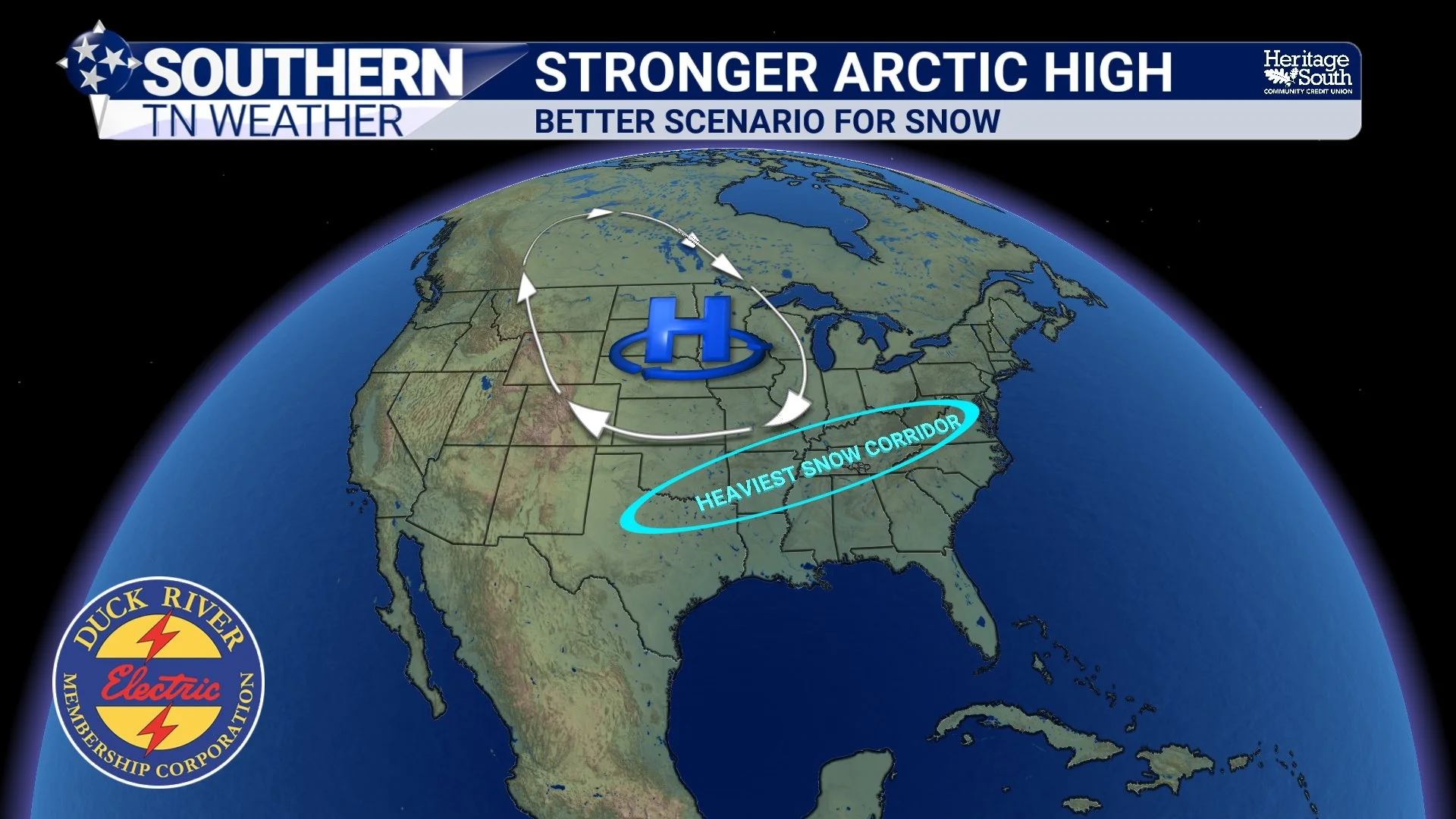
Stronger Arctic High
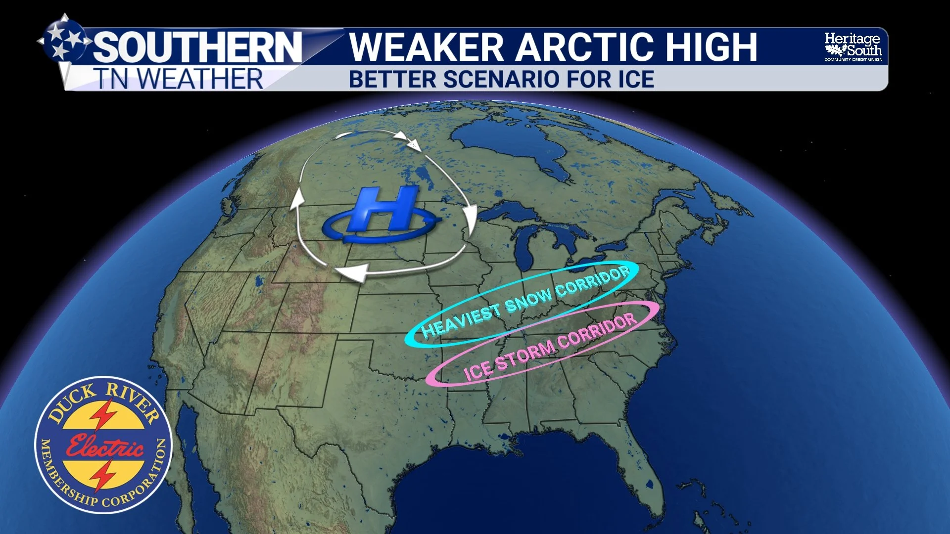
Weaker Arctic High
What This Means for Southern Middle Tennessee
From a local standpoint, this setup places Southern Middle Tennessee in what is often the most challenging forecast zone: the battleground between snow and ice. Both a snowy or icy outcome will produce impacts. Ice is much worse overall, though. At this range, models continue to show large spread in solutions. There are credible scenarios producing primarily snow. There are others favoring mixed precipitation or ice. And there are still solutions that shift the heaviest precipitation south and east.
My current thinking is leaning towards a combination event for our area (especially closer to the AL State Line)… snow with at least some freezing rain potential. I am not ready to talk totals yet, but this is a system that deserves very close attention.
Let’s Talk Probabilities
Instead of totals, probabilities give us a better picture of risk.
The latest National Blend of Models shows:
• 30–50% chance of 6”+ of snow
• 30–50% chance of 0.25"+ of ice
The European Ensemble (a system that runs the same model many times with small variations to measure uncertainty) shows:
• 50–70% chance of 6"+ snow
• 50–70% chance of 0.25"+ ice
The American Ensemble shows:
• 30–40% chance of 6"+ snow
• 40–50% chance of 0.25"+ ice
These are not forecasts. They are overall probabilities. Ensemble and NBM trends are rising. That supports growing confidence in winter weather impacts Friday through Sunday.
Key uncertainties remain:
• Exact storm track (think back to the artic high placement we talked about in the above section)
• Placement of snow/ice lines
• Northern edge of heavy precipitation
Those details will determine who sees snow, who sees ice, and who sees mostly rain — and they will sharpen significantly over the next 48–72 hours.
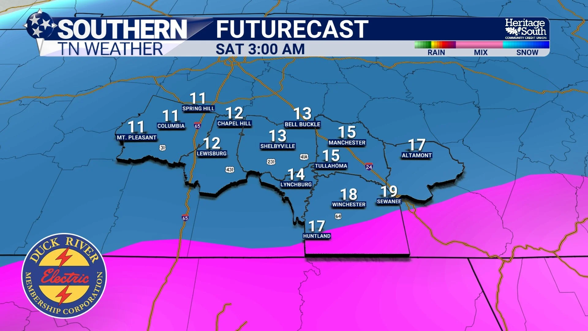
Futurecast - Early Saturday Morning
Cold Will Be an Impact Regardless
Even outside of precipitation, cold is a certainty. Arctic air will be firmly entrenched across the region heading into the weekend. Current guidance supports:
• Widespread teens
• Single digits possible Saturday and Sunday nights
• Potential sub-zero TEMPERATURES early next week
If winter precipitation occurs, these temperatures strongly favor prolonged road impacts, refreezing concerns, and lingering travel issues into deep next week.
The Bottom Line 🧾
• Light rain arrives Wednesday with little impact
• Winter storm signals are strengthening for Friday–Sunday
• Both snow and ice remain realistic outcomes
• Probabilities for impactful winter weather are increasing
• Very cold temperatures will be an issue regardless
• Confidence is growing — details will sharpen daily
This is now a day-by-day forecast evolution situation. The signal is real and the pieces are aligning. The next 48 hours will be critical!
📰 Reminder: The Southern Tennessee Weather Blog (Presented by Heritage South Community Credit Union) is updated Monday through Friday with fresh, locally tailored forecasts you can trust