
Friday Night Winter Storm Update

The Southern Tennessee Weather Blog is proudly presented by Heritage South Community Credit Union.
We Help When Others Won’t!
Visit https://www.heritagesouth.org/ today to see how HSCCU can help YOU!
I’m a little late on the weather blog today — but I promise I’m here and alive. This is going to be a QUICK RUNDOWN blog. Everything I expect over the next 36–48 hours, all in one place, written in a way that’s easy to follow and easy to reference as this storm unfolds.
We are now inside the short range. The overall setup is no longer in question. A significant winter storm is going to impact Southern Middle Tennessee. What matters now is timing, precipitation type, and how long each area stays below freezing. That combination will determine who sees a lot of ice and who ends up dealing with plain rain.
Timing: When It Starts
Precipitation is expected to move into Southern Middle Tennessee between 6 and 10 AM Saturday. Far eastern zones could be slightly later.
👉 Be where you need to be by 6:00 AM at the latest. Once precipitation begins, travel conditions will deteriorate quickly.
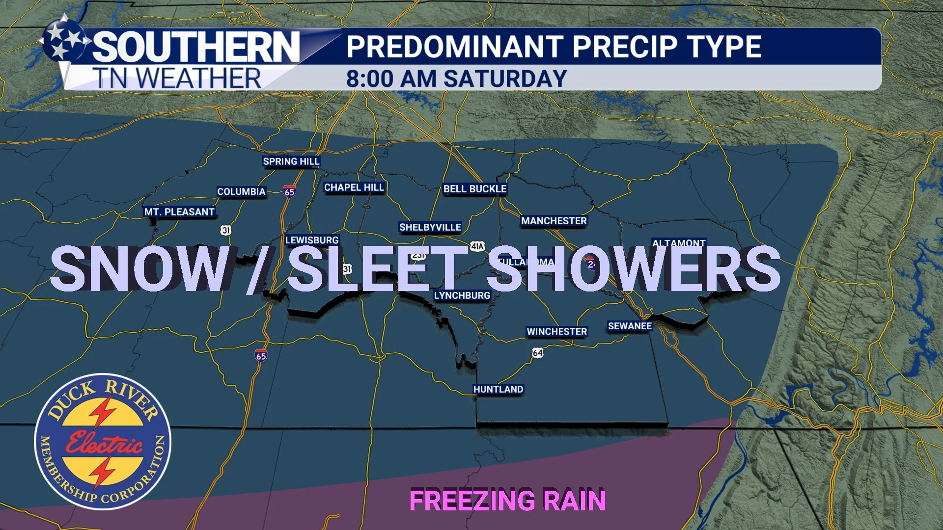
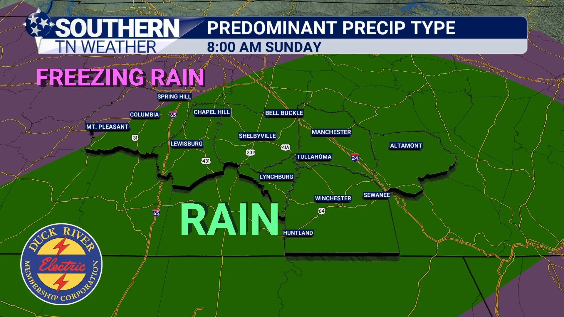
Saturday Morning: Snow & Sleet Onset
I expect precipitation to start as all snow and sleet for everyone. Saturday morning will likely be our only true “winter precipitation” window where we are not dealing with liquid rain aloft. This is when snowfall and sleet accumulation will occur. As we move through the late morning and toward early afternoon, a warm layer of air above the surface (the warm nose) will begin pushing northward. And that’s when the bigger problems begin. The following graphics help give the GENERAL IDEA of what to expect. Don’t take them overly literal in terms of exact placement.
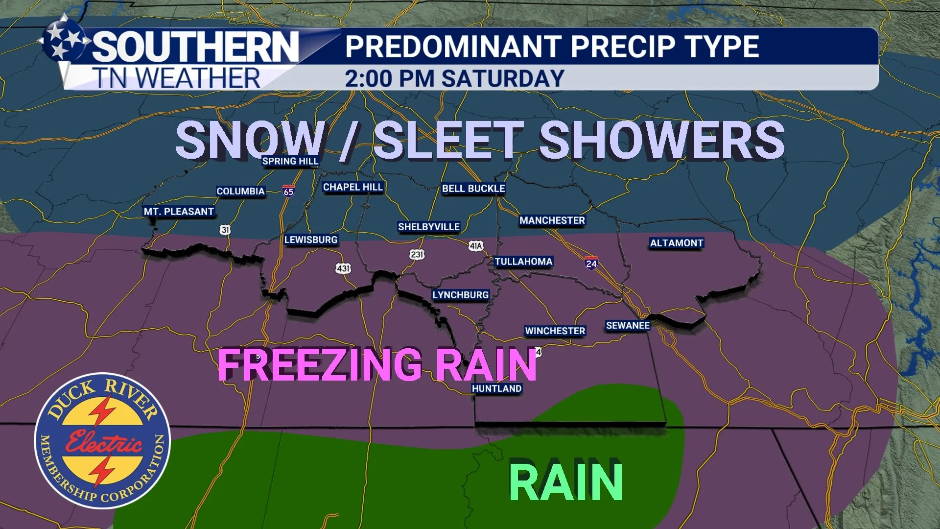
Saturday Midday–Evening: Transition to Freezing Rain
Around noon to 1 PM, a gradual transition from snow/sleet to freezing rain will begin from south to north. This transition will continue through the afternoon and into the evening. By late afternoon into early evening, freezing rain is expected to become the dominant precipitation type for much of the area.
Key point: Freezing rain looks just like normal rain. The difference is it freezes on contact with roads, bridges, trees, and power lines. This is the period where travel impacts rapidly increase and where isolated power outages become possible for everyone.
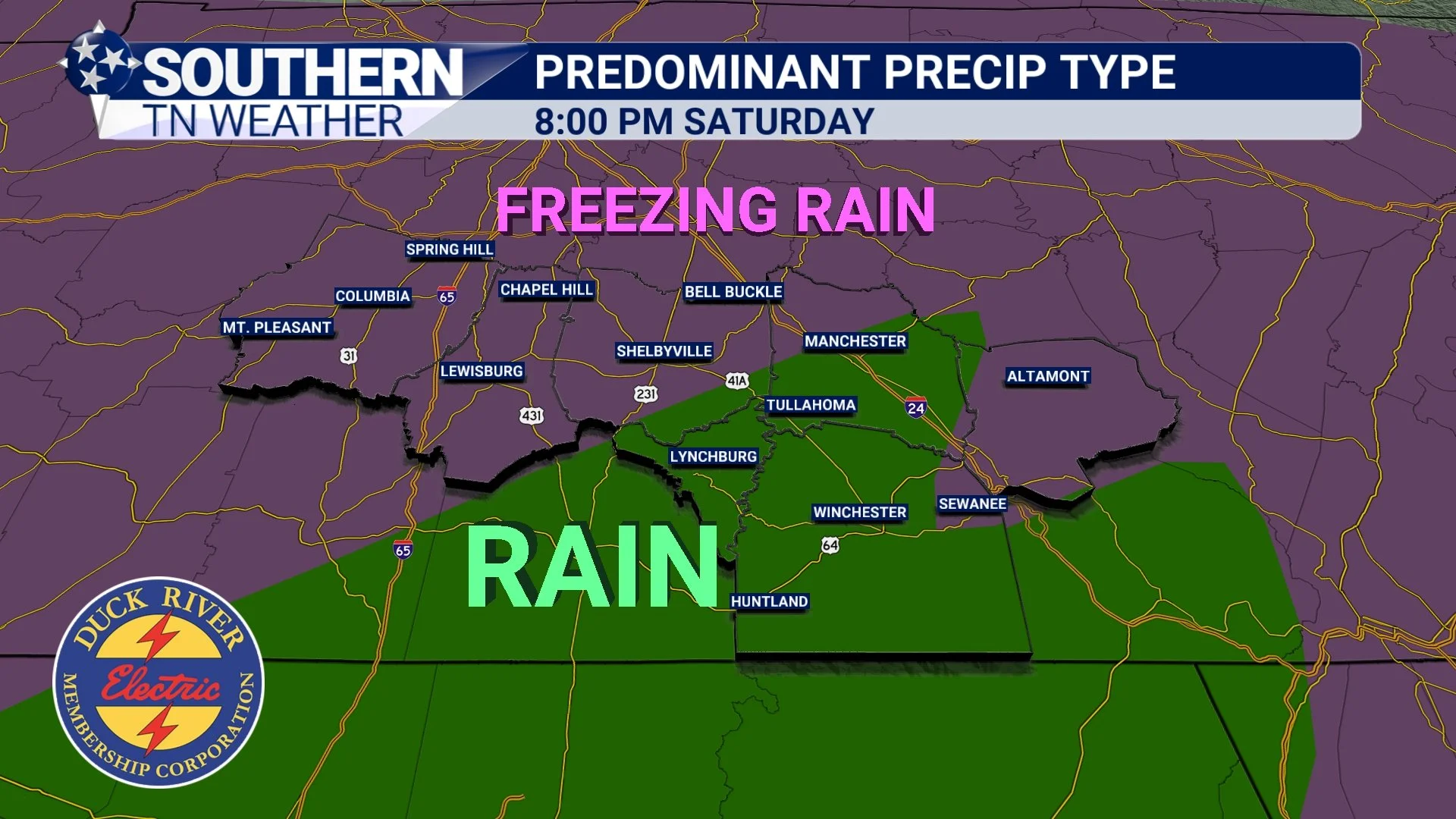
Saturday Night into Early Sunday: Some Areas Change to Rain
Around sunset (or shortly before) I expect plain rain to begin mixing in across the lower elevations of Franklin and Grundy Counties first. As we go later into Saturday night, the rain/freezing line will push north and west.
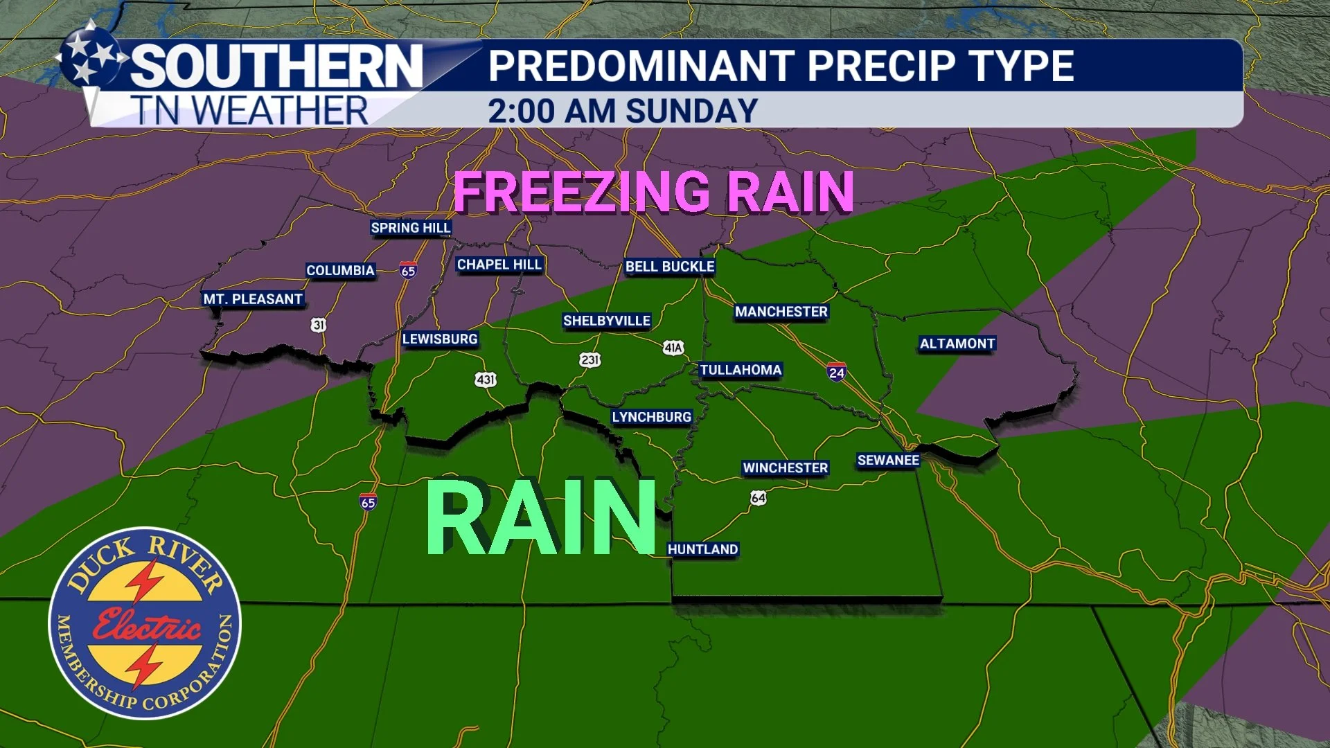
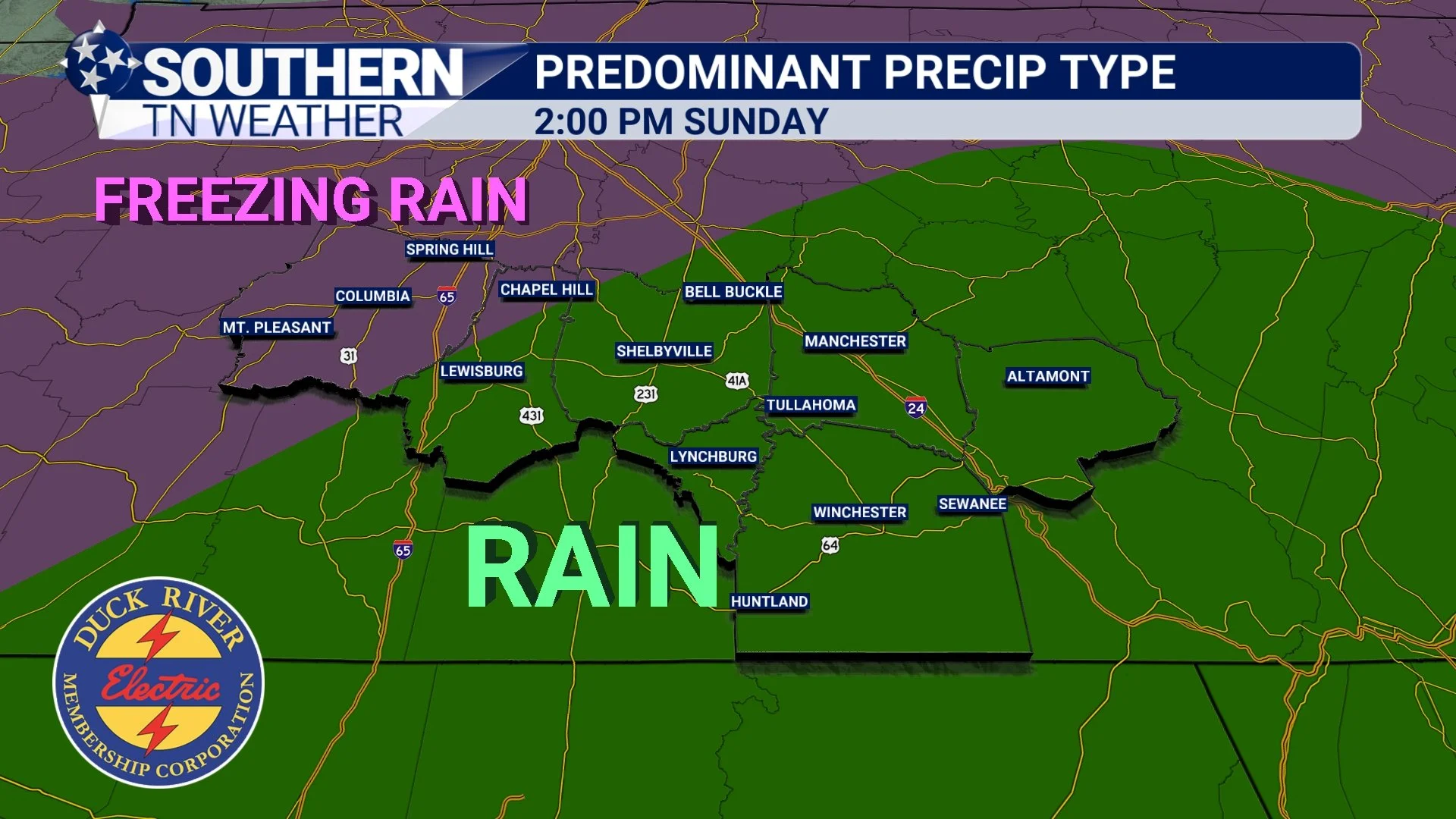
By early Sunday morning, it will likely be splitting our area in half. This is actually good news for places that transition to rain, because it will melt ice and snow accumulations.
The uncertainty is how far north and west that line makes it before stalling. Right now, most guidance supports at least a brief changeover to rain for much of the area. The one place I am still watching closely for a limited or nonexistent transition is Maury County.
Sunday: Cold Air Returns, Then the Storm Winds Down
By late Sunday morning, colder air will begin pushing back in from the northwest. That means some areas that changed to rain may re-transition to freezing rain or sleet before the precipitation shield finally moves out.
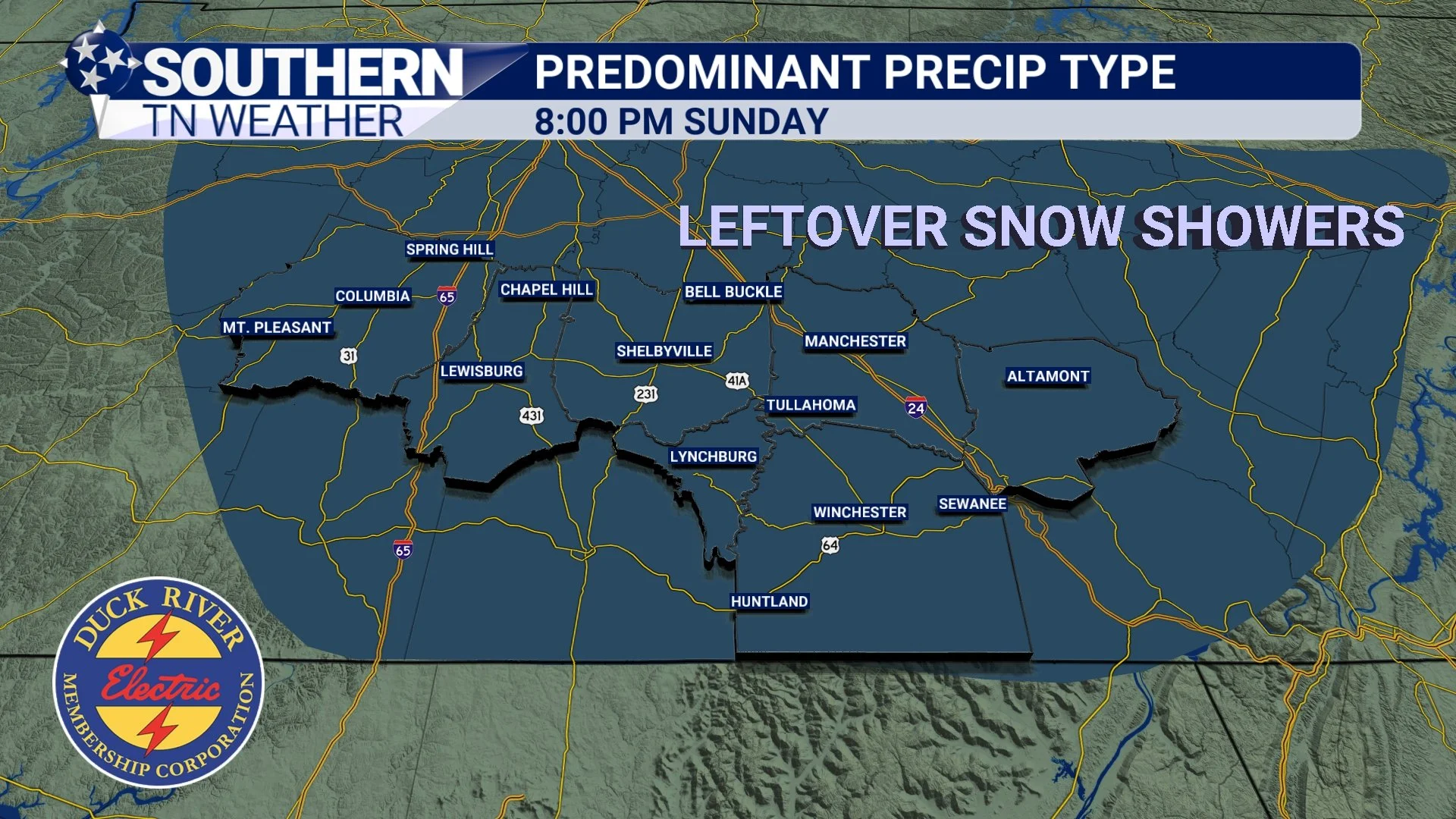
The good news: Right now, it does not look like heavy precipitation will linger very long once the colder air fully returns. However, light snow showers are possible Sunday night into Monday morning.
The Aftermath: Black Ice & Dangerous Cold
Regardless of what falls Saturday and Sunday, the storm does not end when precipitation stops. Widespread black ice is expected Sunday night into Monday morning.
Temperatures will plunge into the single digits, with highs only in the low 20s Monday. Anything wet on the ground will freeze solid.
👉 Monday is shaping up to be a very good day to stay indoors if you can.
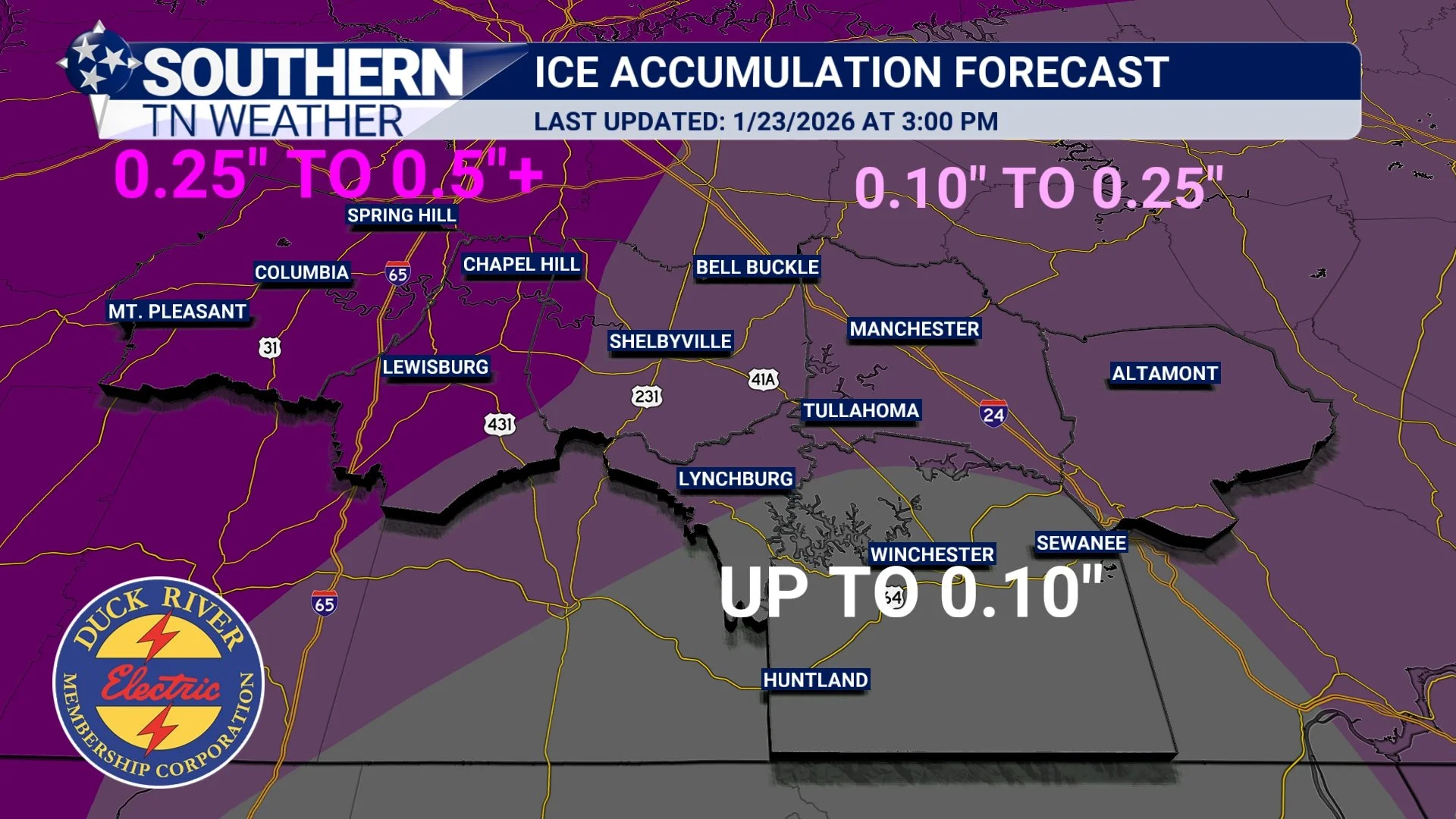
Ice Forecast (Main Threat)
Ice remains the biggest concern with this system. NOTE: THIS FORECAST IS FOR WHAT WILL FALL BEFORE WE TRANSITION TO RAIN
Marshall & Maury Counties:
➡️ 0.25" to 0.50"+ of ice possible
These areas are expected to spend the longest time below freezing. If these areas do not transition to rain, ice totals could exceed 0.50".
Central counties (Bedford, Coffee, Moore, Grundy):
➡️ 0.10" to 0.25" of ice
Franklin County:
➡️ Up to 0.10" of ice
For reference:
• 0.10" = travel impacts
• 0.25" = scattered power outages, major travel issues
• 0.50"+ = widespread power outages possible, potentially impossible travel
These ranges line up very well with the expected freezing-duration gradient.
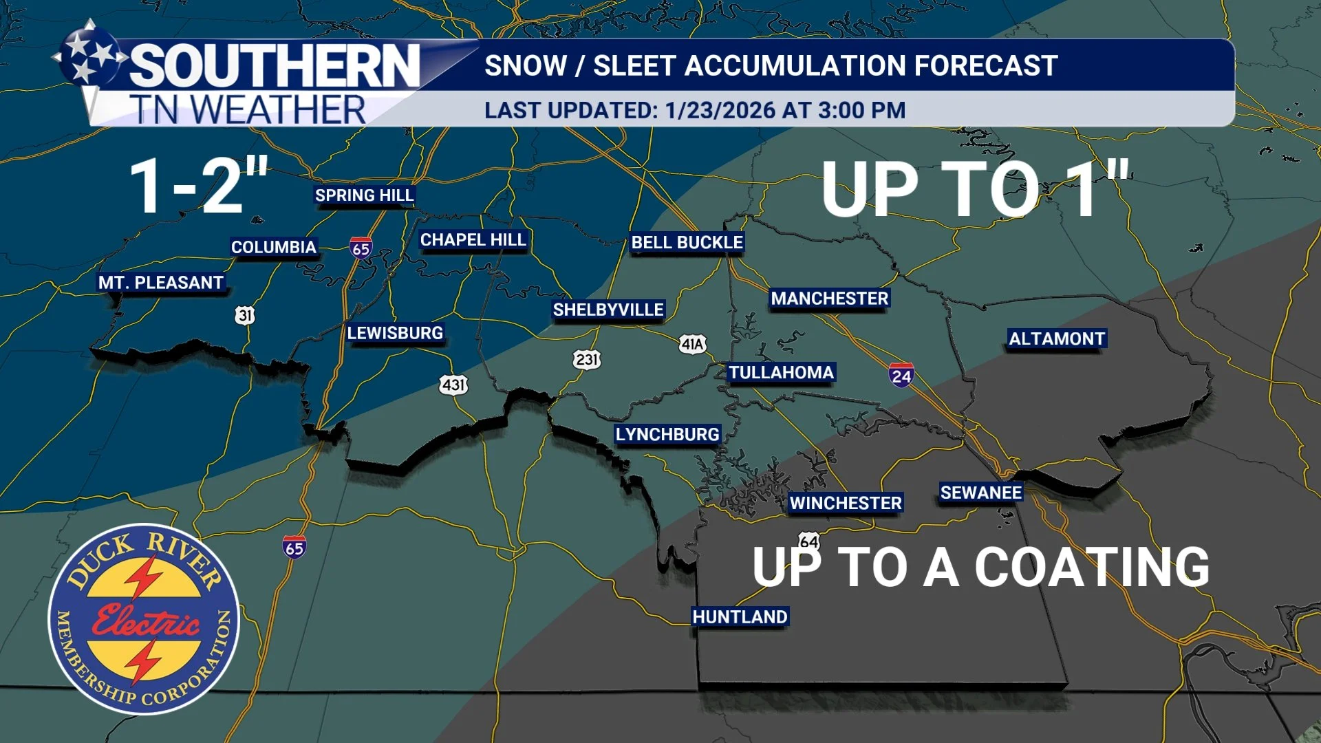
Snow & Sleet Forecast (Primarily Saturday Morning)
Thanks to increasing confidence in a several-hour snow/sleet window at onset, snowfall expectations have increased slightly. NOTE: THIS FORECAST IS FOR WHAT WILL FALL BEFORE WE TRANSITION TO FREEZING RAIN
Marshall, Maury, NW Bedford:
➡️ 1–2 inches
SE Bedford, Coffee, Moore:
➡️ Up to 1 inch
Franklin & Grundy:
➡️ Up to a coating (locally maybe ½")
The Bottom Line 🧾
• Precipitation begins Saturday morning, 6–10 AM as snow and sleet for everyone
• Transitions to freezing rain from south to north midday Saturday
• Some areas will change to rain Saturday night into early Sunday
• Ice remains the primary concern, especially west and north
• Power outages and dangerous travel are possible
• Black ice and bitter cold will extend impacts into Monday
Travel disruptions are likely. Power issues are possible.
Conditions may become unsafe quickly Saturday and remain hazardous into early next week. I will continue monitoring trends closely and will update on social media and the 24/7 weather channel as the storm begins.
Stay weather aware.
Have multiple ways to receive warnings (including the Southern Tennessee Weather App)
And please take this one seriously!
📰 Reminder: The Southern Tennessee Weather Blog (Presented by Heritage South Community Credit Union) is updated Monday through Friday with fresh, locally tailored forecasts you can trust