
Living Life on the Edge Thursday Night

The Southern Tennessee Weather Blog is proudly presented by Heritage South Community Credit Union.
We Help When Others Won’t!
Visit https://www.heritagesouth.org/ today to see how HSCCU can help YOU!
The elephant in the room…
Normally I ease into these blogs, talk about the weather so far today, maybe throw in a fun stat — but not today. Let’s not cut corners: What is the deal with tonight? Rain is already pushing into Southern Middle Tennessee as we move through the afternoon, and this is all tied to a low-impact winter system sliding across Tennessee, southern Kentucky, Virginia, and eventually into the Carolinas. And while “winter system” sounds dramatic, the reality is that this is a borderline event, and even the places that do see wintry weather won’t see major impacts.
Why? Winter weather needs a very specific combination of ingredients to stick: cold air at the ground, cold air above us, and enough moisture falling at once to overcome marginal temperatures. Tonight, surface temps hover right around freezing, precipitation rates are light, and a warm layer above us melts any snow before it reaches the ground. That’s why most of us end up with a plain cold rain.
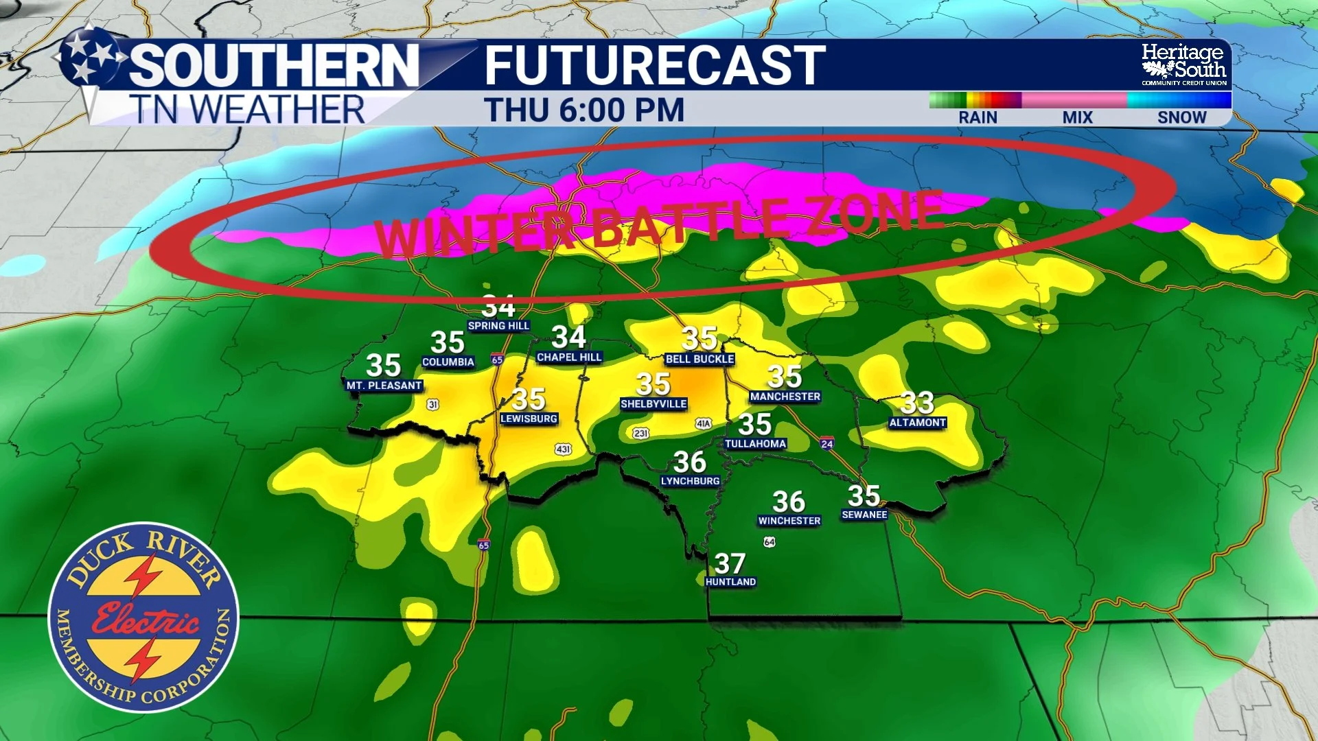
A quick look at tonight’s setup
There is a pocket of warm air above us (the famous “warm nose”) that will melt snowflakes before they reach the ground. The further north you go, the weaker that warm layer becomes, which is why areas along and north of I-40 have the better snow/sleet chances. Up on the Upper Cumberland (Cookeville → Jamestown → Crossville), impacts are most likely because surface temps will be near / at freezing. Here locally across Southern Tennessee, we will be in the “cold rain” category. There have been some model shifts over the past 24 hours, and there was one point yesterday when I was worried about the potential for some wintry precip. But for now, it seems as if the threat has lifted north. The “winter battle zone” shown below is where I expect the transition line between rain / snow / sleet / freezing rain to set up tonight. It’s honestly just going to be a big mess.
Could some sleet pellets or stray flakes mix in, especially in northern Maury County? Sure. But between the weak precipitation rates, marginal surface temperatures, and the warm layer aloft… impacts here are just not looking likely. You can see the temperatures below on the HRRR futurecast. We’ll be within 2-4 degrees of freezing, but it just doesn’t look like we’ll make it there.
Timing
Expect precipitation between now (2-3 PM) and roughly 5 AM Friday. It will not rain continuously, but conditions will be cold, wet, and unpleasant at times.
A cold rain across Southern TN, with a wintry mix along Interstate 40.
Friday (Afternoon) and Saturday
Once precipitation clears Friday morning, it’ll stay cool and cloudy with highs in the mid-40s. Travel conditions should improve quickly as temperatures climb. Saturday also looks dry and mostly cloudy with highs nearing 50 degrees. Plenty of Christmas events are scheduled across the area, and right now things look cooperative.
Our next light rain chance comes Sunday into Sunday night, with very low totals expected. Beyond that, another weak system may brush the area mid-week. The pattern we are in right now favors small disturbances rather than any large, organized storm systems.
Rainfall Totals
As I’ve been stating the past few days, moisture is quite limited with tonight’s system. Most locations will see under a quarter inch, with a few spots maybe reaching that.
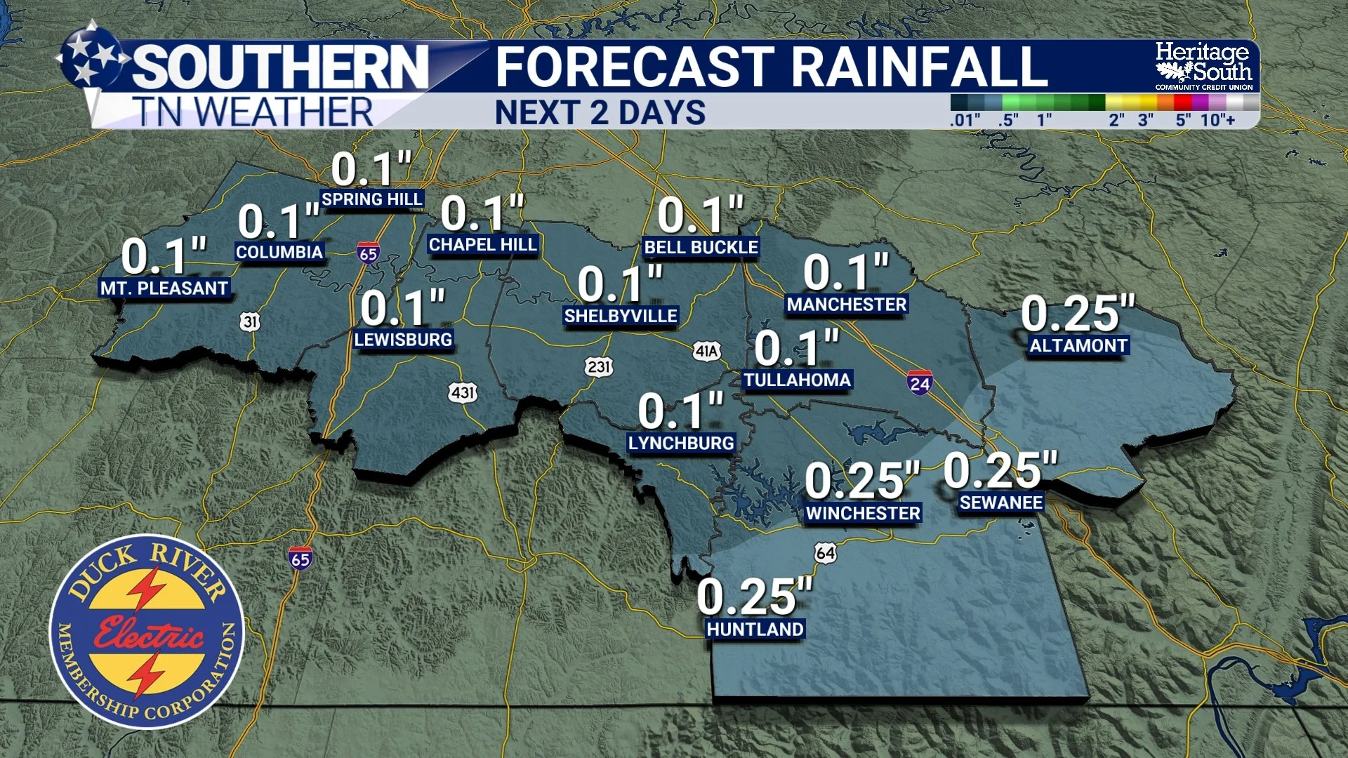
Rainfall Totals over the next 2 days
The Bottom Line
• A cold rain is expected for most of Southern Middle Tennessee
• A wintry mix is most likely on the Cumberland Plateau, where a Winter Weather Advisory is in effect
• Very limited impacts expected locally, aside from some slick spots north and northeast of us
• Precipitation ends Friday morning, with improving travel conditions
• Dry and cool Friday afternoon and Saturday
• Light rain chances return Sunday and again mid-week
📰 Reminder: The Southern Tennessee Weather Blog (Presented by Heritage South Community Credit Union) is updated Monday through Friday with fresh, locally tailored forecasts you can trust.