
A Pretty Quiet Week Ahead… Cold Blast Soon?

The Southern Tennessee Weather Blog is proudly presented by Heritage South Community Credit Union.
We Help When Others Won’t!
Visit https://www.heritagesouth.org/ today to see how HSCCU can help YOU!
A cloudy and cool Monday…
Late November and early December have really settled into a pattern: cloudy, chilly, hazy, and damp. We had a weak little system roll through late Sunday night that brought scattered light showers, but rainfall totals were unimpressive – generally around a tenth of an inch or less. Today is more of the same. Clouds have been stubborn to break, and the latest NWS forecast discussion notes a strong inversion overhead (warmer, dry air sitting above colder, humid air near the surface). That traps the stratus deck in place and keeps temperatures chilly. Most of us will barely make it out of the 30s this afternoon.
Tonight, lows slip back into the 20s. If clouds clear even partially, freezing fog could develop thanks to saturated ground, high near-surface moisture, and calm winds. It’s not a guarantee, but something to keep in mind for the Tuesday morning commute.
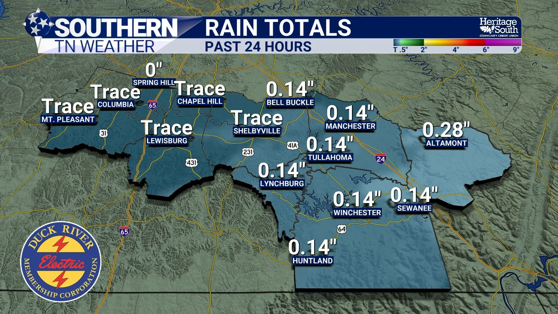
Rainfall Totals - Past 24 Hours
A Quiet Stretch Ahead
High pressure will slowly take over tonight and hold through Wednesday, giving us a break from the gray, raw weather we’ve been stuck in. Temperatures will improve too:
Tuesday highs: upper 40s to near 50
Wednesday highs: low to mid 50s
More sunshine both days, especially Tuesday afternoon
These temps are still below seasonal norms (we should be in the upper 50s this time of year), but it’s definitely improvement from the cold, gloomy conditions we’ve dealt with lately.
Cold Weather Next Weekend… But HOW Cold?
I previewed this on social media yesterday – long-range data had been hinting at a major cold snap this weekend, potentially bringing lows in the teens and highs struggling to get above freezing. The newest data, however, has backed off the extreme solution.
The NWS AFD confirms that an Arctic air mass will spill south behind a late-week cold front, but the coldest core of that air looks to remain suppressed a bit farther north. The overall pattern still supports a sharp cooldown, but not necessarily the “brutal cold” some models were throwing out a few days ago.
Here’s the current thinking:
Lows in the low 20s still look very likely
Teens for lows are still possible, but becoming a lower-confidence scenario
Highs in the 30s this weekend are still on the table
No significant precipitation is expected with the front
Sunshine looks likely behind the front thanks to strong high pressure
Below is the upper-air temperature map for Sunday. Note how the coldest pink/purple shading stays north of us. If that shifts even a little farther south later in the week, the colder solution could return… so this is something I’ll be watching closely.
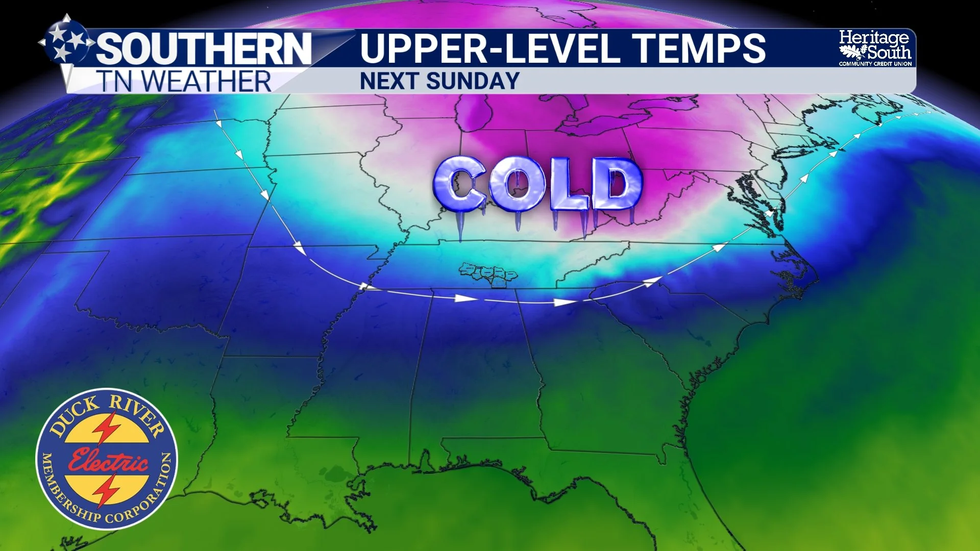
Upper-Level Temps - Sunday
Seven-Day Forecast Overview
The upcoming week looks remarkably quiet for early December. We won’t be dealing with any major storm systems, and outside of a very small chance for a passing shower Thursday night, the forecast stays dry thanks to a broad area of high pressure. Temperatures will climb into the 50s on Tuesday and Wednesday — still a bit below normal for this time of year, but warmer than the cloudy, chilly pattern we’ve been stuck in lately.
Late week and into the weekend, a stronger cold front will sweep through and pull down a fresh push of Arctic air. The latest data shows the core of the coldest air staying just far enough north to spare us from the harshest values, but a sharp cooldown is still expected. Highs may only reach the 30s this weekend, and lows in the low 20s (with a few teens possible) are certainly on the table. Sunshine looks likely behind the front as high pressure re-establishes itself.
It’s not an exciting forecast, but honestly a quiet stretch with some sunshine will feel pretty good after the gloom we’ve had!
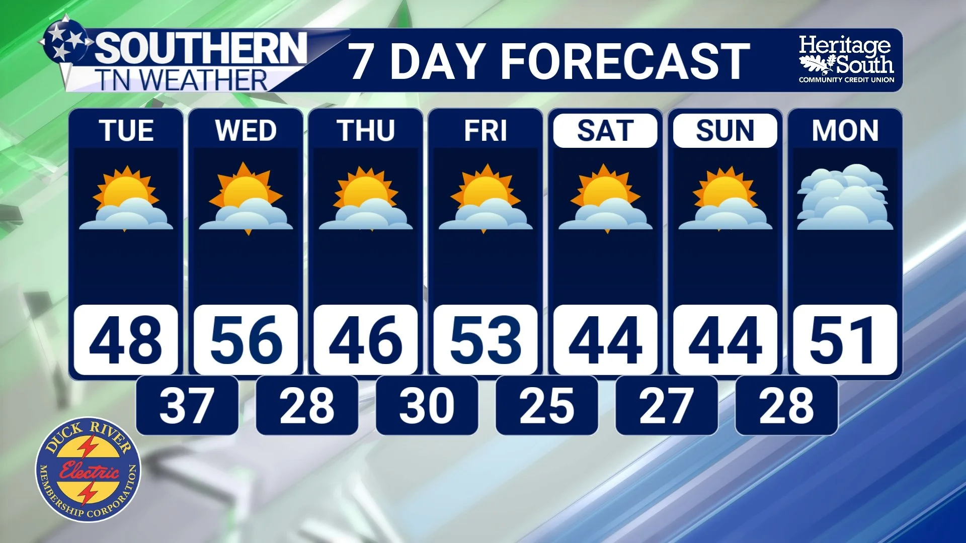
7-Day Forecast
The Bottom Line
• A quiet stretch of weather is ahead through midweek
• Highs warm into the 50s Tuesday and Wednesday under high pressure
• A sharp cooldown still expected this weekend, though not as extreme as earlier model runs
• Lows in the low 20s look likely; teens are still possible
• Little to no rain is expected over the next 7 days
• Sunshine makes a return — finally!
📰 Reminder: The Southern Tennessee Weather Blog (Presented by Heritage South Community Credit Union) is updated Monday through Friday with fresh, locally tailored forecasts you can trust.