
A Full Breakdown On What To Expect Thursday

The Southern Tennessee Weather Blog is proudly presented by Heritage South Community Credit Union.
We Help When Others Won’t!
Visit https://www.heritagesouth.org/ today to see how HSCCU can help YOU!
Well, the comfortable weather was nice while it lasted. Over the past few days, Southern Middle Tennessee has enjoyed lower humidity, cool nights, and pleasant afternoons. Unfortunately, that's quickly becoming a distant memory as Gulf moisture surges back into the region.
Today's weather is really the transition day. Tomorrow is when things get interesting. If you've got outdoor plans this week, today is by far your best opportunity to enjoy them before a much more active weather pattern settles in for Thursday and early Friday.
Today Sets The Stage
One of the first signs of our changing weather pattern can already be seen overhead. Clouds associated with Tropical Storm Arthur have begun spreading into the region, while winds have shifted back around to the south. Those southerly winds are acting like a conveyor belt, transporting warm, humid Gulf air back into Southern Middle Tennessee.
Highs today will climb into the upper 80s with dewpoints rising into the lower and middle 70s. In other words, the Tennessee summer swamp has returned. While an isolated shower can't be completely ruled out, most locations should remain dry through the day and tonight.
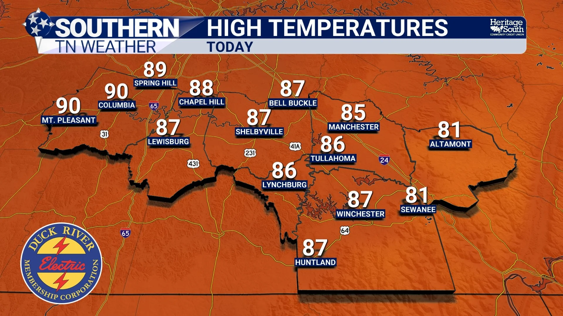
HIGH TEMPERATURES - TODAY
Two Weather Systems, One Forecast
Thursday's forecast is complicated because we're dealing with two separate weather systems working together. The first is the remnants of Tropical Storm Arthur, which will continue moving inland across the Gulf Coast states. The center of circulation should remain well south of Tennessee, but the tropical moisture surrounding the system won't.
At the same time, a cold front will be approaching from the northwest. Think of tropical moisture as the fuel and the cold front as the spark. When those two ingredients come together, they provide an environment favorable for widespread showers and thunderstorms. Southern Middle Tennessee happens to sit right where those two systems will interact.
Timing Looks Better
Over the past day or so, forecast confidence has improved somewhat regarding the timing. At this point, I expect showers and thunderstorms to begin increasing Thursday morning, with the most active period likely occurring during the afternoon and evening hours. The weather should remain unsettled Thursday night before gradually improving during the day Friday as the cold front pushes through the area.
What Are The Main Threats?
The two biggest concerns remain damaging wind gusts and heavy rainfall. A few thunderstorms Thursday afternoon and evening could become strong enough to produce isolated damaging winds, especially as daytime heating adds additional instability to the atmosphere. The overall severe weather threat remains fairly low. The strongest upper-level winds and wind shear remain displaced north of our area, limiting the potential for widespread organized severe weather. A Marginal Risk (level 1/5) remains in place for severe thunderstorms.
Heavy rainfall, however, may become the bigger story. Tropical air masses are incredibly efficient rainfall producers because they contain enormous amounts of moisture. Meteorologists measure this using something called precipitable water, or PWAT. By Thursday, values across our area could climb to around two inches, which is well above average for this time of year. That means any thunderstorm that develops will have the ability to produce torrential rainfall in a short amount of time.
The Weather Prediction Center continues to place our area under a Slight Risk (level 2/4) for excessive rainfall. It's important to note that this does not mean widespread flooding is expected. Rather, it means localized flooding could occur where heavier storms repeatedly move across the same locations. Right now, the forecast calls for half an inch to one inch of rain with this event. Although some may see more while others see less.
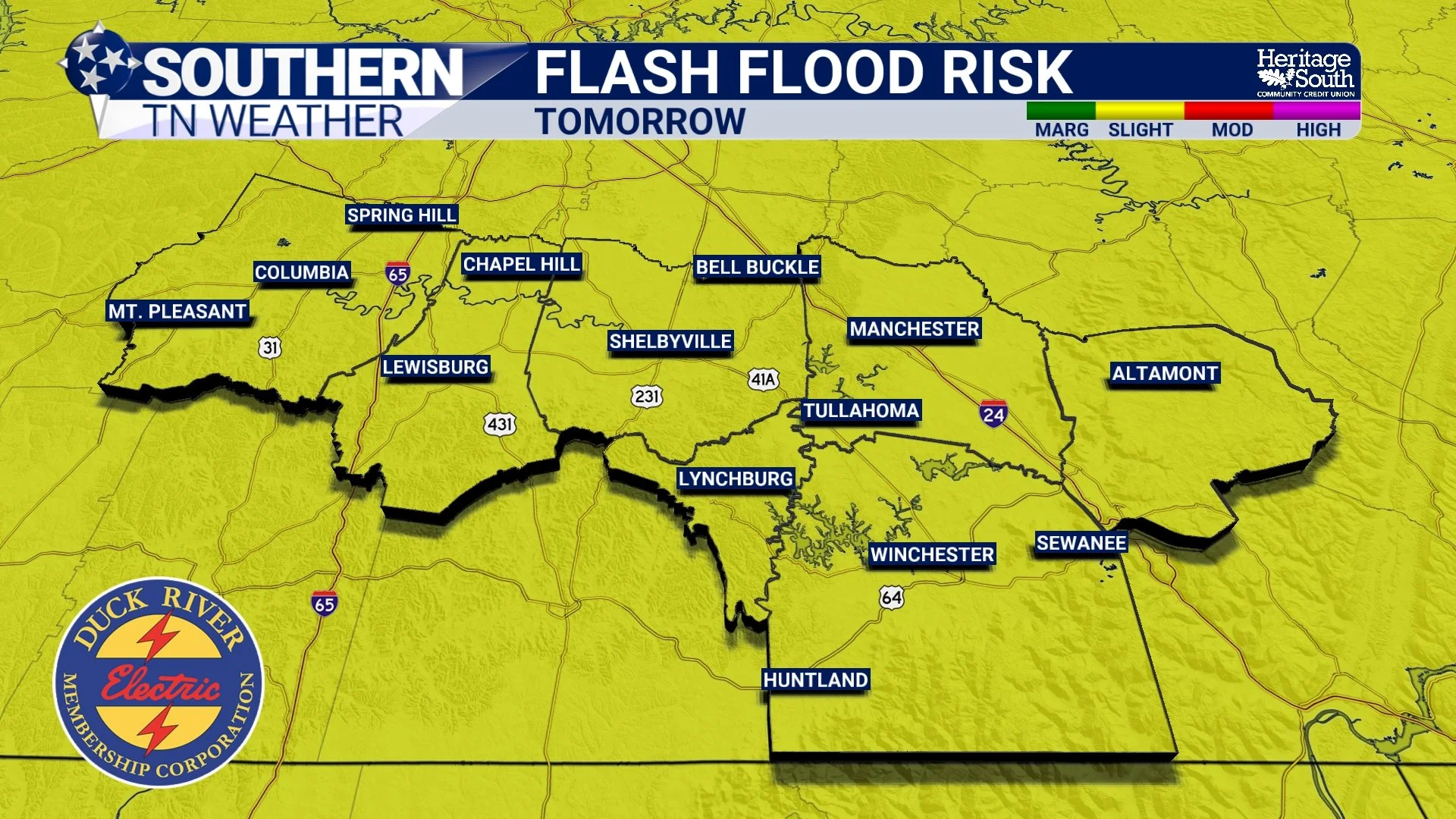
FLASH FLOOD RISK - TOMORROW
So... Should We Be Worried?
At this point, I don't think Thursday looks like a high-end severe weather event. Rain and thunderstorms are highly likely. A few storms could become strong. Heavy rainfall and localized flooding will be possible. But widespread severe weather does not appear likely.
As always, summertime weather can evolve quickly, and small changes in the track of Arthur's remnants or the timing of the approaching cold front could alter the forecast somewhat. I'll continue monitoring trends and provide updates as needed.
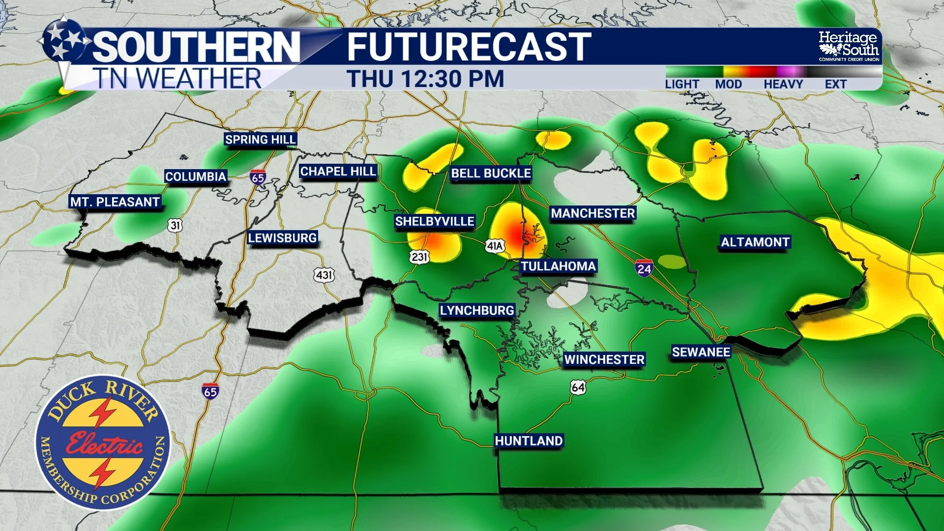
FUTURECAST - THURSDAY AFTERNOON
Friday Through The Weekend
Showers and thunderstorms will likely continue into Friday morning before gradually ending from northwest to southeast during the afternoon as the cold front clears the area. The reward for getting through Thursday and Friday looks pretty nice.
Saturday is shaping up to be another pleasant early summer day with lower humidity and dry conditions returning across Southern Middle Tennessee. Unfortunately, the quiet weather won't stick around for long. Rain chances begin increasing again Sunday and Monday as another disturbance approaches the region, although it's too early to get overly concerned about any severe weather potential.
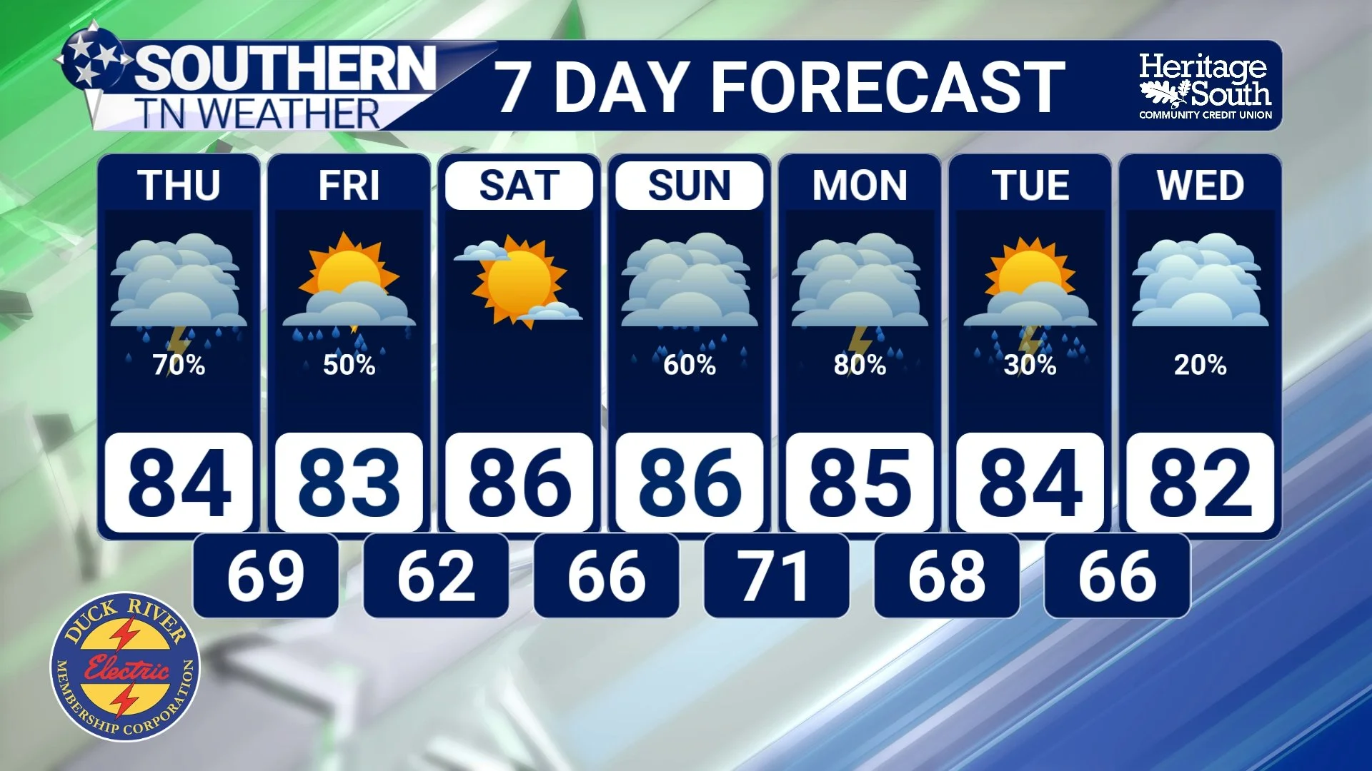
STNWX 7-DAY FORECAST
The Bottom Line 🧾
Today is the last mainly dry day before our active weather returns.
Tropical moisture from Arthur and an approaching cold front will combine over Tennessee.
Showers and thunderstorms become likely Thursday into early Friday.
The most active period appears to be Thursday afternoon and evening.
Damaging winds and heavy rainfall are the primary concerns.
Localized flooding is possible, but widespread flooding is not expected.
Storms gradually move out by Friday afternoon.
Saturday looks dry and pleasant before rain chances increase again Sunday and Monday.
📰 Reminder: The Southern Tennessee Weather Blog, presented by Heritage South Community Credit Union, is updated Monday through Friday with fresh, locally tailored forecasts you can trust.