
Why Summer Thunderstorms Live Fast And Die Young

The Southern Tennessee Weather Blog is proudly presented by Heritage South Community Credit Union.
We Help When Others Won’t!
Visit https://www.heritagesouth.org/ today to see how HSCCU can help YOU!
The weather across Southern Middle Tennessee has been about as nice as it gets this week. Sunshine, comfortable humidity, cool mornings, and afternoon temperatures in the lower 80s have provided a welcome break from the active weather pattern that dominated much of May. That quiet stretch isn't expected to last forever, however.
While dry weather remains in place through Saturday, shower and thunderstorm chances will gradually begin returning later this weekend and into next week. And when they do, many of the storms we'll be tracking won't be the large, organized systems we often see during the spring. Instead, they'll be the classic summertime "popup" thunderstorms that seem to appear out of nowhere, dump heavy rain on one neighborhood, and then vanish just as quickly as they formed. What makes these storms so fascinating is how short their lives often are. In many cases, a summer thunderstorm can develop, mature, and dissipate in less than an hour.
It All Starts With Sunshine
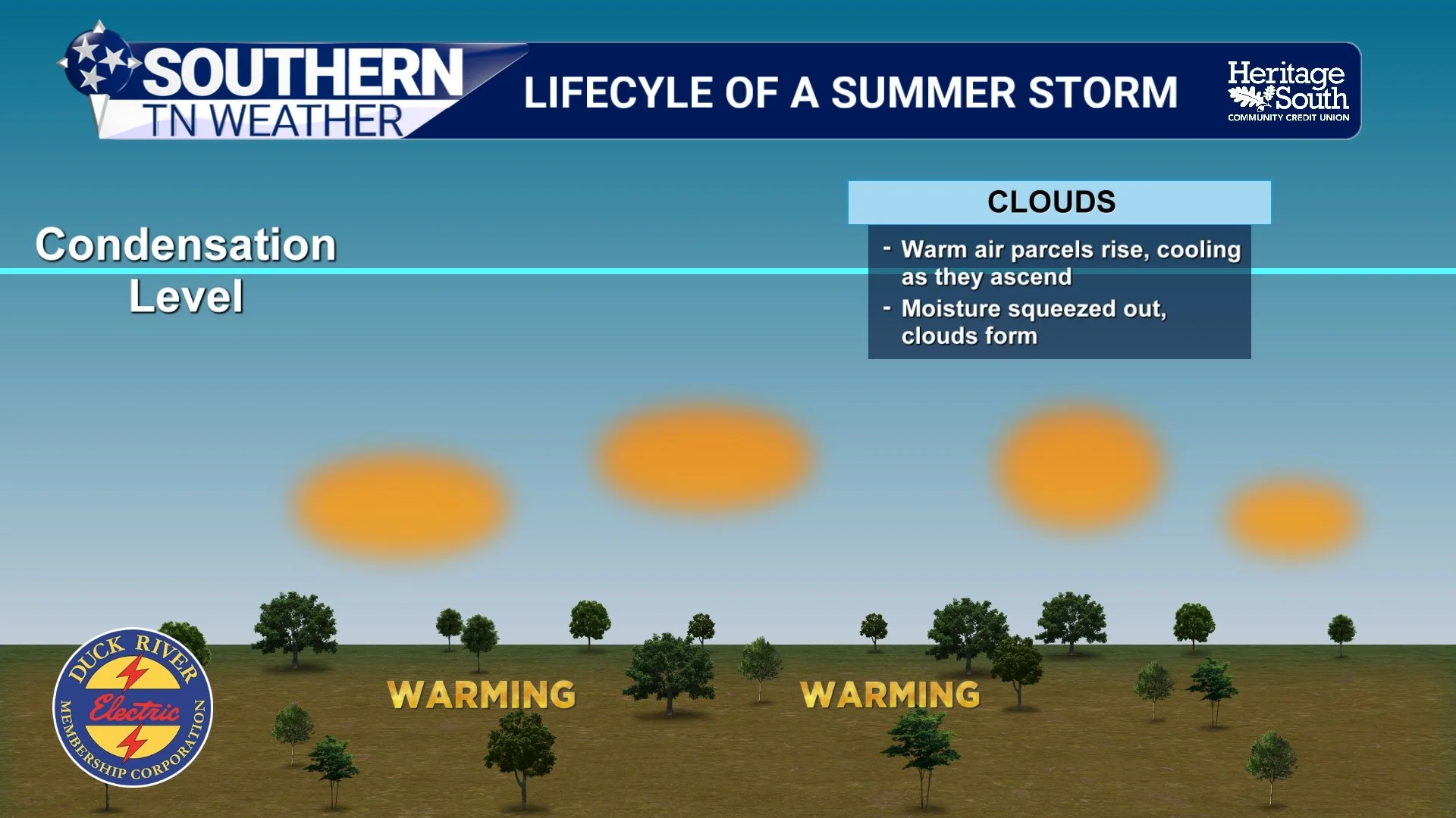
Believe it or not, every summer thunderstorm begins with a sunny day. As the sun heats the ground during the afternoon, the air directly above the surface warms as well. Since warm air is less dense than cool air, it naturally begins to rise through the atmosphere. The stronger the heating becomes, the stronger those upward currents can grow. This is one of the reasons thunderstorms are far more common during the afternoon than during the morning. The atmosphere needs time to build up energy before storms can develop.
As the rising air climbs higher into the atmosphere, it begins to cool. Eventually it cools enough for water vapor to condense into tiny droplets, creating the puffy fair-weather cumulus clouds we often see on warm summer afternoons. Most of those clouds never become thunderstorms. But some continue growing…
LIFECYCLE OF A SUMMER STORM - P1
From Puffy Clouds To Thunderstorms
When conditions are favorable, those harmless-looking cumulus clouds continue building vertically into the atmosphere. Meteorologists refer to this as the cumulus stage of a thunderstorm's life cycle. At this point, the cloud is being fueled almost entirely by rising warm air. From the ground, these are the towering cauliflower-shaped clouds that seem to grow larger by the minute. As long as warm, moist air continues feeding into the cloud, it can keep growing taller and taller.
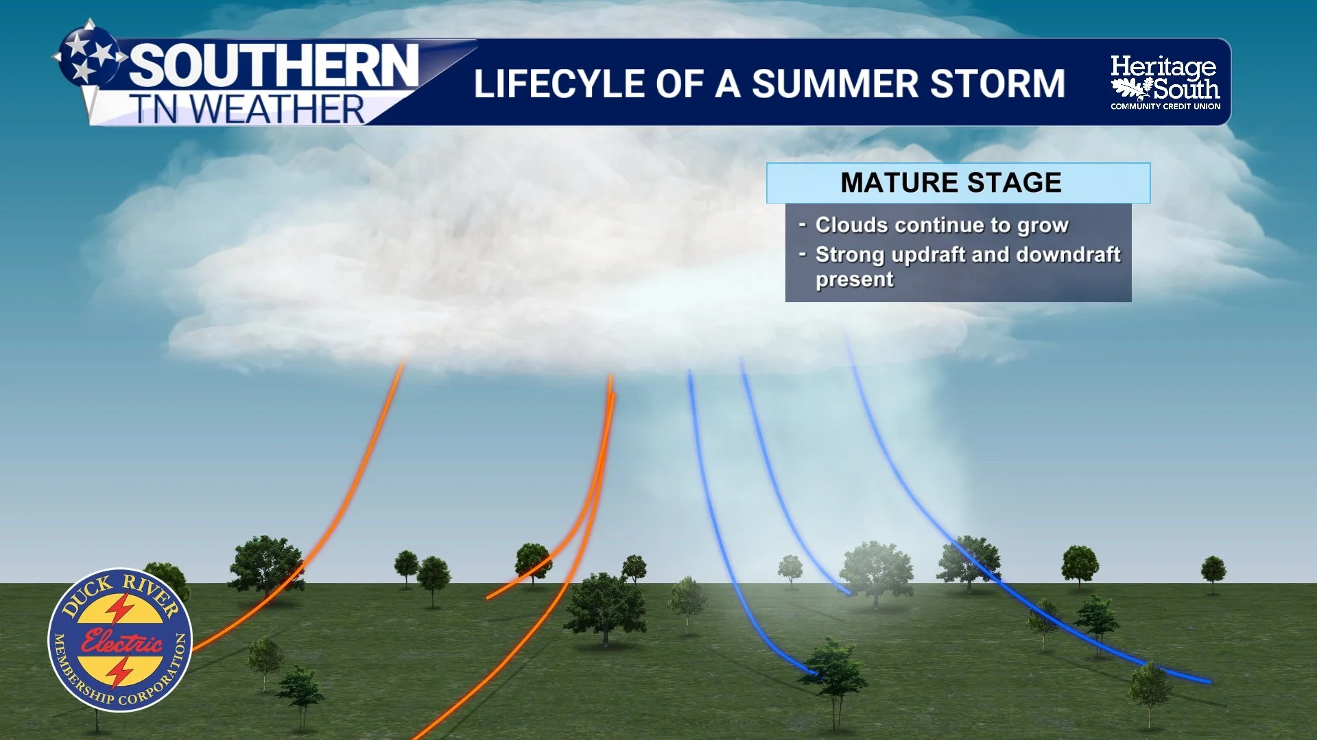
Eventually, however, the cloud becomes large enough for raindrops to begin forming inside the storm. That's when the thunderstorm enters its mature stage and reaches peak intensity. This is typically when the weather becomes most noticeable. Heavy rainfall develops, lightning becomes frequent, and gusty winds often begin spreading away from the storm. In stronger storms, small hail may also occur. For a brief period, the storm is operating at maximum efficiency. Strong updrafts continue pulling warm air upward while rain and cooler air begin descending toward the ground. But that balance doesn't last long.
LIFECYCLE OF A SUMMER STORM - P2
The Storm Eventually Defeats Itself
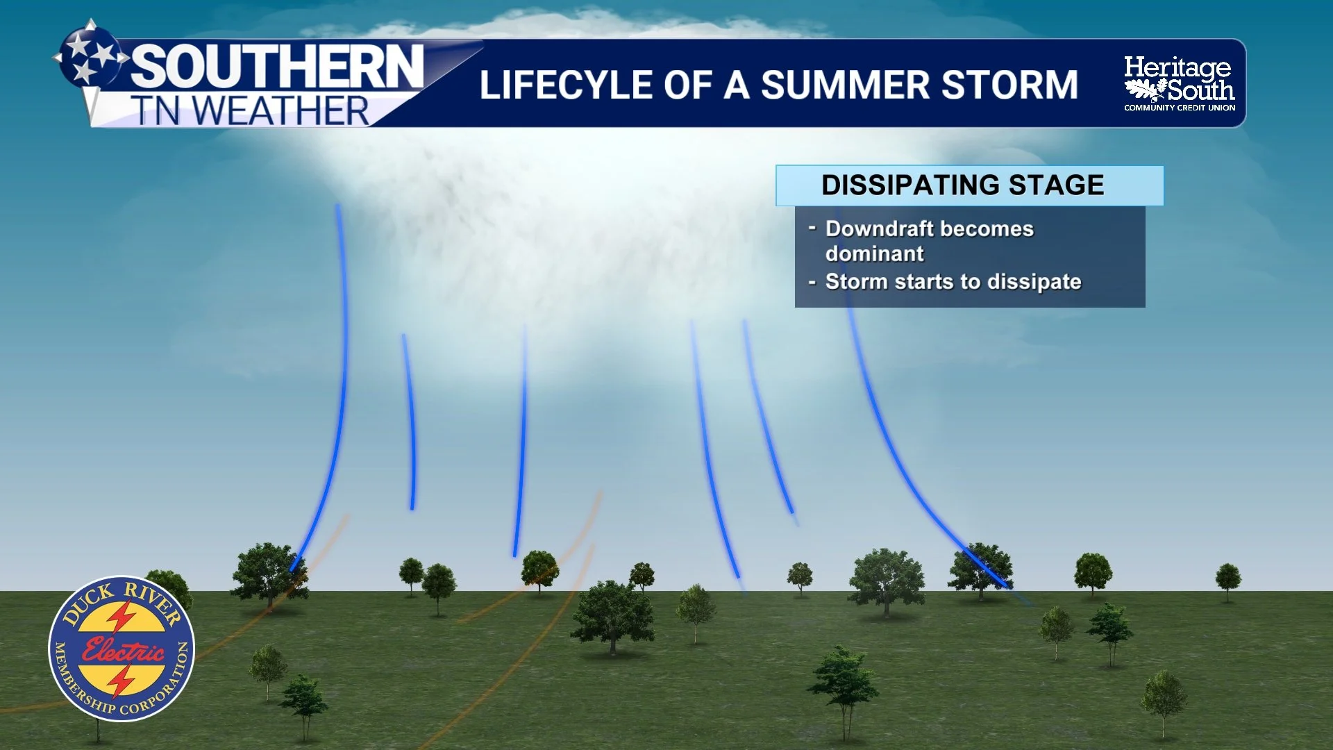
One of the most interesting aspects of a summer thunderstorm is that the very process that makes it strong also leads to its collapse. As rain falls through the storm, it drags cooler air toward the surface. Once that cooler air reaches the ground, it spreads outward in all directions. Meteorologists call this a downdraft. Over time, the downdraft grows stronger and stronger until it begins interfering with the storm's supply of warm rising air. Eventually, the cool air essentially cuts off the storm's fuel source.
Without a steady stream of warm air feeding into the cloud, the thunderstorm begins to weaken. Rainfall gradually decreases, lightning becomes less frequent, and the towering cloud starts losing its structure. Before long, the storm dissipates completely. The entire process(from a small cumulus cloud to a thunderstorm and back again) can happen in less time than it takes to watch a television show.
LIFECYCLE OF A SUMMER STORM - P3
Why One Town Gets Rain And Another Doesn't
This rapid life cycle is one of the reasons summer weather can be so frustrating to forecast. Unlike spring storm systems, which can span multiple states and be tracked days in advance, summertime thunderstorms are often isolated and highly dependent on local conditions. Small differences in temperature, moisture, or leftover boundaries from previous storms can determine exactly where a thunderstorm forms. That's why Tullahoma may receive a soaking rain while Shelbyville stays dry, or why one side of a county can measure an inch of rainfall while the other side barely sees a sprinkle.
It's also why rain chances become more difficult to communicate during the summer months. Meteorologists can often identify when storms are likely to develop somewhere, but determining exactly which community will get rain is often much more challenging.
Looking Ahead
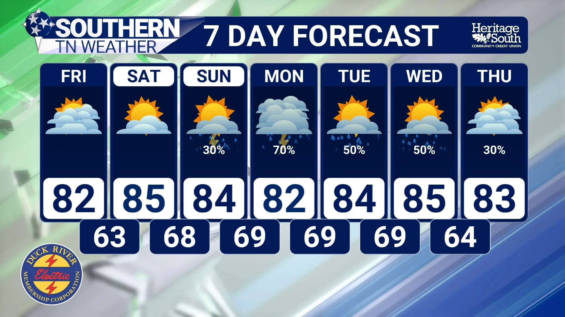
For now, Southern Middle Tennessee will continue enjoying several more days of pleasant weather. Dry conditions remain in place through Friday, while temperatures gradually warm from the lower 80s into the middle and upper 80s by the weekend. As humidity slowly increases and Gulf moisture begins returning to the region, scattered showers and thunderstorms will once again become part of the forecast beginning Sunday and continuing into next week. The good news is that no organized severe weather threat is currently on the horizon. Instead, we're looking at the type of scattered afternoon thunderstorms that are common across Tennessee during the summer months.
And when those storms begin popping up again next week, you'll know exactly how they form, why they grow so quickly, and why they often disappear just as fast!
STNWX 7-DAY FORECAST
The Bottom Line 🧾
Summer thunderstorms often complete their entire life cycle in less than an hour.
Every storm begins with sunshine warming the ground and causing air to rise.
Growing cumulus clouds can quickly evolve into thunderstorms when conditions are favorable.
Thunderstorms reach peak intensity during their mature stage before eventually weakening.
Rain-cooled air ultimately cuts off a storm's fuel supply and causes it to dissipate.
Dry weather continues through Saturday before scattered storm chances return late this weekend and into next week.
📰 Reminder: The Southern Tennessee Weather Blog, presented by Heritage South Community Credit Union, is updated Monday through Friday with fresh, locally tailored forecasts you can trust.