
The Atmospheric Tug-Of-War Happening Over Tennessee Right Now

The Southern Tennessee Weather Blog is proudly presented by Heritage South Community Credit Union.
We Help When Others Won’t!
Visit https://www.heritagesouth.org/ today to see how HSCCU can help YOU!
If you've stepped outside this week, you've probably noticed that something feels different. The air has been noticeably more comfortable. Mornings have felt refreshing. The sky has been a deeper shade of blue. Even afternoon temperatures in the lower and middle 80s have felt pleasant compared to what we often experience in June.
The reason isn't just luck. The beautiful weather we've enjoyed this week is the result of a large area of high pressure that settled across the eastern United States following weeks of active weather and heavy rainfall across Tennessee. That system has provided several consecutive days of sunshine, lower humidity, and rain-free conditions across Southern Middle Tennessee.
But the atmosphere is already beginning to change. In fact, one of the more interesting things I'm watching right now isn't today's weather at all. It's the battle beginning to unfold between the dry air mass that has been in control this week and the warmer, more humid air mass that is slowly pushing northward from the Gulf of Mexico. Understanding that tug-of-war helps explain not only our current forecast, but also why the weather pattern will look much different by the time we reach next week.
The Dry Air Won The First Round
This week's weather has been dominated by surface high pressure positioned to our east and northeast. High pressure systems are typically associated with sinking air, which suppresses cloud development and makes it difficult for showers and thunderstorms to form. The result has been a stretch of weather that many people wish would last all summer long.
Afternoon temperatures have remained close to seasonal averages while overnight lows have dropped into the 50s and lower 60s. Humidity levels have been significantly lower than what we experienced throughout much of May, making even the warmer afternoons feel comfortable. The combination of dry air and abundant sunshine has also allowed the atmosphere to gradually warm over the last several days. While temperatures haven't been excessively hot, the ground and lower atmosphere have been quietly storing heat beneath the persistent sunshine. That warming trend becomes important as we head into the weekend.
The Bermuda High Is Beginning To Flex Its Muscles
One of the defining features of summer weather across the Southeast is something known as the Bermuda High. This semi-permanent area of high pressure typically strengthens over the western Atlantic Ocean during the warmer months and often expands westward toward the southeastern United States. As it does, winds across Tennessee gradually shift out of the south and southwest.
That change in wind direction may not sound significant, but it has major implications for our weather. Instead of receiving air from the north and east, we begin tapping into the Gulf of Mexico. The atmosphere essentially opens the door for warmth and moisture to stream northward into Tennessee. That's exactly what is beginning to happen now.
The high-pressure system that has protected us this week is slowly retreating eastward, and southerly flow is becoming established across the region. As a result, temperatures will continue warming through the weekend while dewpoints slowly begin climbing as well. You may not notice a dramatic difference on Saturday, but by Sunday most people will likely realize the atmosphere feels considerably different than it did earlier this week.
The Weekend Is A Transition Zone
One reason weather patterns can be difficult to forecast during these transitions is because neither air mass completely wins right away. The dry air doesn't simply disappear overnight, and the humid Gulf air doesn't instantly take over. Instead, they battle for position.
That's why the forecast this weekend contains a little bit of everything. Saturday should remain largely rain-free with temperatures climbing into the middle and upper 80s. The atmosphere will still retain some of the dry characteristics we've enjoyed this week, but moisture will be increasing behind the scenes. By Sunday, however, a surface boundary is expected to develop somewhere near Middle Tennessee while a larger upper-level disturbance organizes to our west. At the same time, humidity levels will continue increasing as Gulf moisture becomes more firmly established across the region.
The ingredients for thunderstorms will begin coming together.
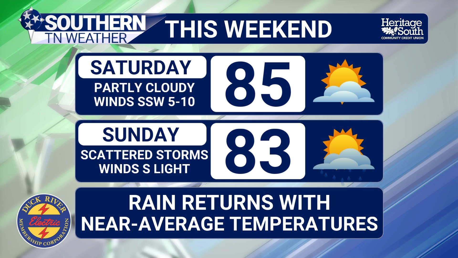
STNWX - THIS WEEKEND
Summer Begins To Reclaim Tennessee
As we move into Sunday and early next week, the atmosphere starts looking much more like a typical Tennessee summer pattern. The good news is that I'm not seeing signs of a significant severe weather setup. Wind shear remains fairly weak, which should limit storm organization. While a stronger storm can't be completely ruled out, the overall severe weather threat appears very low for the foreseeable future.
Instead, the primary concerns will be locally heavy downpours, frequent lightning, and the possibility of minor flooding in areas that happen to get caught beneath multiple storms. In fact, atmospheric moisture levels may climb above the 90th percentile for early June by Sunday. That's a fancy way of saying the atmosphere will contain plenty of water vapor, allowing any thunderstorms that develop to become very efficient rain producers.
This doesn't necessarily mean everyone receives heavy rainfall. Like many summer setups, rainfall will likely be highly variable from one community to the next. Some locations may receive a beneficial soaking rain while others see very little at all. In total, 1-2 inches of rain can be expected over the next 7 days.
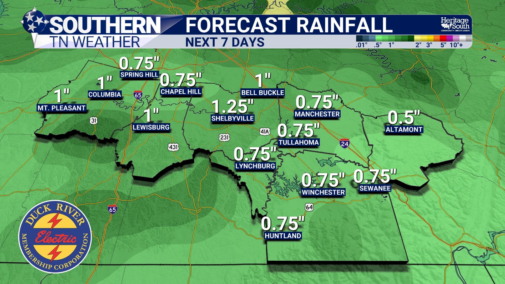
FORECAST RAINFALL - NEXT 7 DAYS
Looking Ahead
In many ways, this weekend marks the unofficial end of the pleasant bonus weather we've enjoyed this week. The atmosphere is gradually shifting away from a pattern dominated by dry air, sunshine, and cool mornings and back toward the weather Tennessee is famous for during the summer months. Humidity will continue increasing, temperatures will climb into the upper 80s and eventually lower 90s, and scattered afternoon thunderstorms will once again become part of the forecast.
The transition won't happen all at once, but the tug-of-war is already underway. And after several days of beautiful weather, the humid side of the atmosphere is beginning to gain ground.
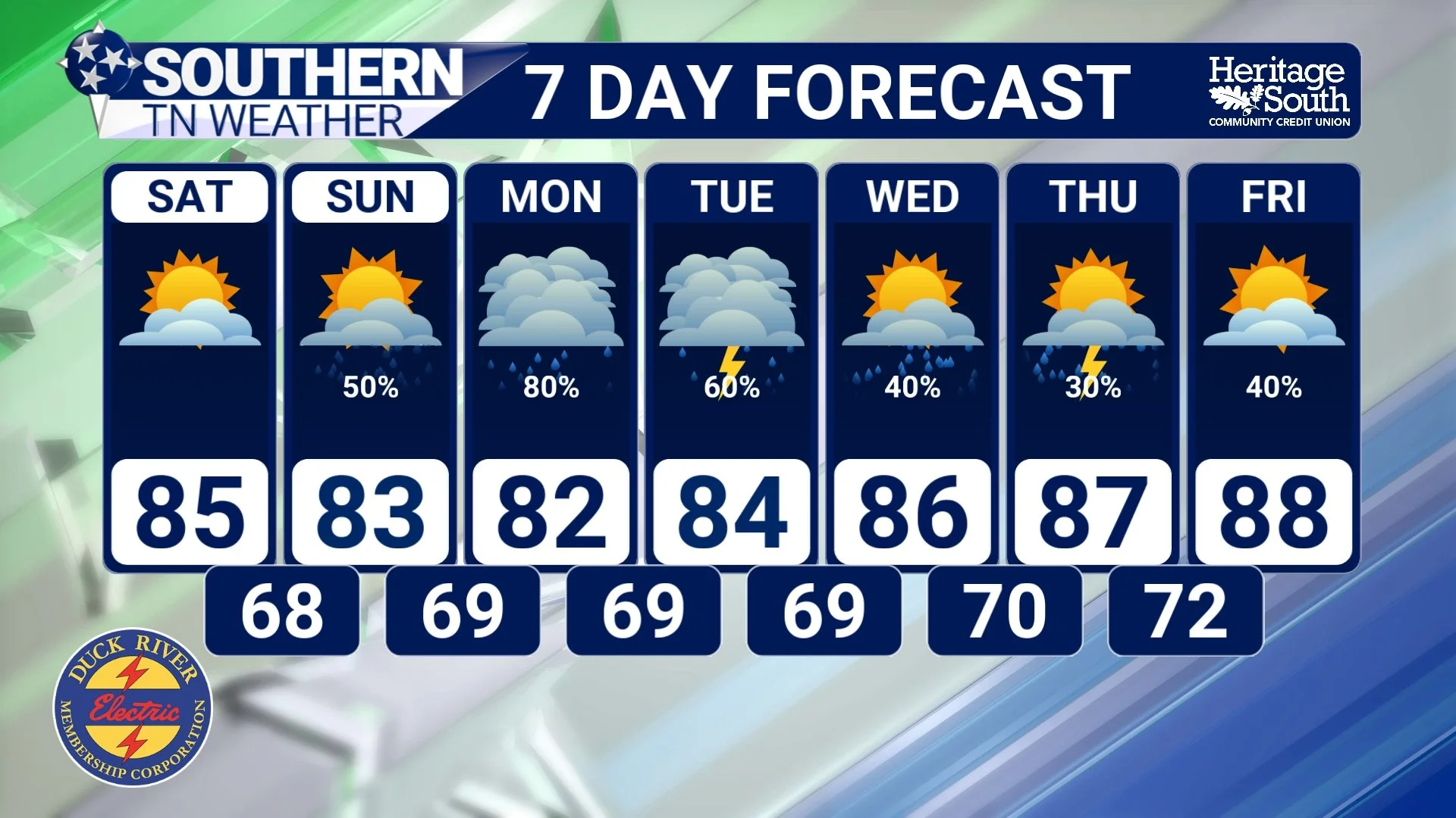
7-DAY FORECAST
The Bottom Line 🧾
Rain-free weather continues through Saturday.
Temperatures will gradually warm into the middle 80s this weekend.
Humidity levels will steadily increase through Sunday.
A surface boundary and approaching upper-level disturbance will help spark storm development.
Shower and thunderstorm chances return Sunday and continue into next week.
Heavy downpours and lightning will be the primary concerns with any storms.
The overall severe weather threat remains very low.
A more typical summertime weather pattern takes hold across Southern Middle Tennessee next week.
📰 Reminder: The Southern Tennessee Weather Blog, presented by Heritage South Community Credit Union, is updated Monday through Friday with fresh, locally tailored forecasts you can trust.