
Why Is a Slow, Soaking Rain Better Than a Quick Downpour During a Drought?

The Southern Tennessee Weather Blog is proudly presented by Heritage South Community Credit Union.
We Help When Others Won’t!
Visit https://www.heritagesouth.org/ today to see how HSCCU can help YOU!
After weeks of staring at brown grass, dusty ground and an increasingly ugly Drought Monitor, we're finally getting closer to something Southern Middle Tennessee desperately needs: RAIN. Rain chances will begin increasing Friday and remain elevated into the weekend, with current forecasts supporting the potential for a widespread soaking rainfall across much of the area. Some guidance suggests 0.5 to 2 inches could fall across portions of the region from Friday through Monday, although, as we discussed in Monday's blog, exact rainfall totals can and WILL continue changing as we get closer.
But let's say I gave you a choice. Would you rather receive two inches of rain in 45 minutes or two inches spread gradually across 12 hours? If we're trying to put a dent in the drought, give me the slower rain almost every time. Both scenarios technically put two inches into the rain gauge, but what happens to that water after it reaches the ground can be VERY different. Ending a drought isn't simply about how much rain falls from the sky. We also care about how much of that water actually makes its way into the soil instead of immediately running into ditches, creeks and rivers.
That's where a good, old-fashioned soaking rain becomes incredibly valuable.
STNWX BLOG TITLE PAGE
It All Comes Down to Infiltration
When rain reaches the ground, some of that water begins moving downward into the soil through a process called infiltration. That water can replenish moisture in the upper layers of the soil where grasses, crops and trees can use it, while some may eventually penetrate deeper and contribute to groundwater and streamflow. The ground, however, can't absorb an unlimited amount of water instantaneously. Every soil has a certain rate at which water can infiltrate, and that rate depends on several things, including the type of soil, how compacted it is, how much moisture is already present, vegetation, land use and even the slope of the terrain.
Think about pouring water onto a sponge. If you slowly drizzle water onto it, the sponge has time to absorb quite a bit. Dump the entire glass onto it at once and some of that water will simply rush across the surface before the sponge has a chance to take it in. Soil can behave similarly. If a thunderstorm dumps two inches of rain in 45 minutes and the rainfall rate exceeds how quickly the ground can absorb water, the excess has to go somewhere. More of it begins flowing across the surface into low spots, ditches, storm drains, creeks and eventually rivers. That's runoff.
Spread those same two inches over several hours and the ground has considerably more time to accept the water as it arrives. More of that rainfall has an opportunity to soak downward and replenish soil moisture rather than immediately racing toward the nearest creek. That's why how quickly the rain falls can be just as important as how much rain falls.
There is one important wrinkle when we're dealing with drought, though. You've probably heard people say that extremely dry ground becomes so hard that rain simply “bounces off.” That's an oversimplification. Dry soil can often absorb a tremendous amount of water because there's plenty of room available for moisture. However, prolonged drought can also leave some surfaces crusted, compacted or otherwise less receptive to water initially, and the exact response varies tremendously depending on the soil. That's another reason a gentle rain at the beginning of a drought-relief event can be so helpful. The first rainfall can begin moistening those upper layers without immediately overwhelming them. Continued moderate rainfall then has an opportunity to penetrate farther downward. You can almost think of it as priming the ground before the main event.
Two Inches Isn't Always Two Inches
This is also why looking at a storm-total rainfall map doesn't tell us everything we need to know. Imagine two locations both receive exactly 2.00 inches of rain. At Location A, a thunderstorm dumps those two inches in 40 minutes. Water quickly starts pouring off roads and parking lots, ditches begin filling, smaller creeks respond rapidly and a substantial amount of water is moving across the surface. At Location B, those same two inches fall steadily over 10 hours. The rainfall rate remains manageable enough that the ground has much more time to accept the water, allowing more of it to replenish soil moisture before eventually reaching streams and rivers.
The rain gauges at both locations may say 2.00 inches, but the benefit to the soil and the response of nearby waterways can be very different. Terrain matters, too. Water falling on a steep hillside naturally has an easier time running downhill than water falling across relatively flat terrain. Vegetation can help slow that movement and give rainfall additional time to soak into the ground, while concrete, pavement and other developed surfaces dramatically increase runoff.
Then there's the issue of coverage. One thunderstorm could dump three inches of rain over a small portion of Bedford County while locations 10 miles away receive almost nothing. That's great for whoever gets underneath the storm, but it doesn't do much to improve a drought affecting a large portion of Southern Middle Tennessee. A widespread one- or two-inch rain falling at manageable rates can therefore be considerably more beneficial than isolated pockets receiving three or four inches from intense thunderstorms. When we're talking about drought relief, we don't simply want a huge number somewhere on the rainfall map.
We want widespread, manageable rainfall that has time to soak into the ground. And even if we get exactly that this weekend, one good rainfall event doesn't necessarily mean our drought immediately disappears. We've used the moisture savings account analogy before, and it works particularly well here. Over the past several weeks, we've made withdrawal after withdrawal through excessive heat, evaporation, plant transpiration and very little widespread rainfall. A two- or three-inch soaking rain would represent a BIG deposit into that account, but it doesn't necessarily replace everything we've lost.
Topsoil moisture can respond relatively quickly, and lawns and vegetation may look dramatically better within days. Streams can rise, and some of our shorter-term drought indicators may begin improving. Deeper soil moisture and groundwater, however, can take considerably longer to recover. That's why several widespread soaking rain events separated by manageable breaks would be about as good of a drought-relief pattern as we could ask for. Let one round fall slowly enough to soak into the ground, give the landscape some time to absorb it, and then bring another round later.
Of course, there eventually comes a point where the soil becomes increasingly saturated. Once those available spaces in the ground begin filling with water, additional rainfall becomes much more efficient at producing runoff. That's when creeks and rivers can begin responding much more quickly and flooding concerns can increase. So yes, you absolutely can have flooding during a drought. The two are not mutually exclusive.
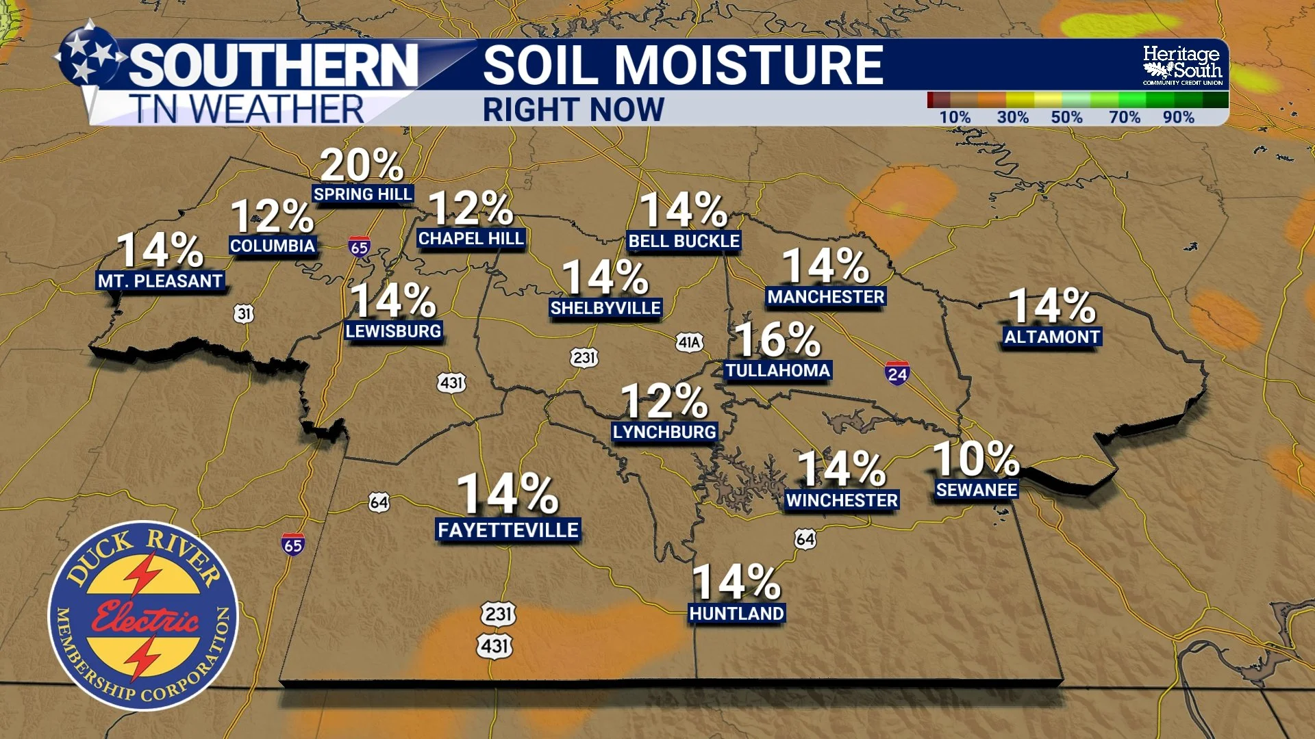
SOIL MOISTURE - RIGHT NOW
Could This Weekend Deliver the Kind of Rain We Need?
That's what makes the upcoming weekend forecast so interesting. First, we've got to get through another brief blast of late-season heat. Highs Wednesday through Friday will run well above normal across Southern Middle Tennessee, generally reaching the upper 80s and lower 90s, with some of our warmer locations potentially climbing into the middle 90s. Humidity will also gradually increase as southerly winds transport substantially more moisture into the region. Then the pattern changes. Rain chances begin increasing Friday as an approaching disturbance and cold front interact with a rapidly moistening atmosphere. By Friday night and Saturday, the amount of moisture available in the atmosphere will become unusually high for this time of year, with precipitable water values potentially climbing above 2 inches in portions of the region.
You don't need to remember the term “precipitable water.” The important part is that it tells us the atmosphere will be absolutely LOADED with moisture compared with what we've experienced lately, which means showers will be capable of producing rainfall very efficiently. Current guidance suggests 0.5 to 2 inches of rain could fall from Friday through Monday across portions of the region, although there is still uncertainty in exactly where the highest totals develop. Rain chances become medium to high Friday into Saturday, with the heaviest rainfall currently expected sometime between Friday afternoon and Sunday morning.
There are some encouraging signs for drought relief in this particular setup. Instability may remain relatively limited across portions of the area, meaning this may not simply be an event dominated by intense thunderstorms dumping enormous amounts of rain over tiny areas. Periods of widespread showers could allow rain to fall over a longer duration, which is much closer to the kind of rainfall we would like to see. However, the atmosphere will contain so much moisture that any heavier showers or thunderstorms that DO develop could produce very heavy rainfall. If a band of heavy rain becomes nearly stationary or repeatedly moves over the same locations, totals could pile up quickly enough to create localized flooding.
That's the balancing act we'll be watching closely over the next couple of days. If we receive two or three inches spread relatively evenly across the weekend, FANTASTIC. That's exactly the type of widespread soaking rainfall that could put a meaningful dent in our drought. If two or three inches falls in only a couple of hours? That's when beneficial rainfall can quickly become too much of a good thing.
Thankfully, rain chances should begin decreasing Sunday as the front gradually moves through. Cooler and drier air will follow, with temperatures falling considerably by early next week. After highs potentially reaching the lower 90s late this week, we could be talking about highs only in the 70s behind the front. So we're about to go from hot and increasingly humid, to potentially wet, and then right back into some beautiful fall weather. September apparently wanted to make sure October knew how to make an entrance!
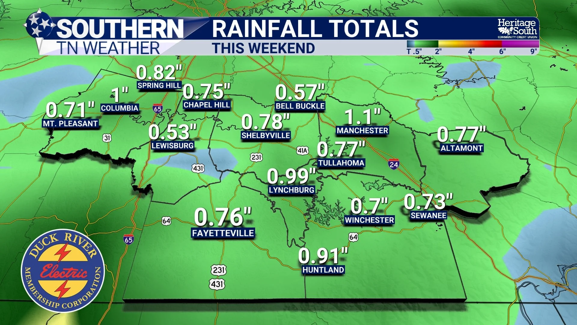
RAINFALL TOTALS - THIS WEEKEND
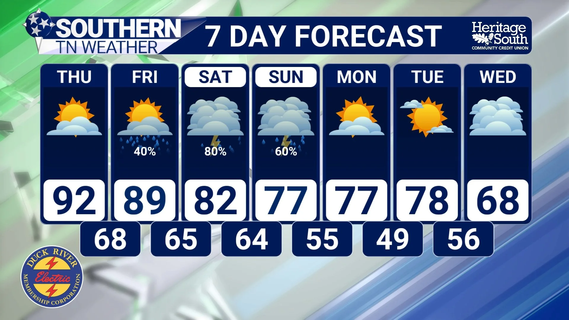
STNWX 7-DAY FORECAST
The Bottom Line 🧾
🌧️ Slow, steady rainfall is generally better for drought relief than an intense downpour because it gives water more time to soak into the soil.
💦 If rainfall arrives faster than the ground can absorb it, more of that water becomes runoff and flows into ditches, creeks and rivers.
🧽 Think of the ground like a sponge. Slowly adding water gives it more time to absorb moisture than dumping everything onto it at once.
🌱 Soil type, compaction, vegetation, terrain, rainfall intensity and how wet or dry the ground already is all influence how much water can infiltrate.
🌵 Extremely dry ground does NOT automatically mean all rainfall will run off, although some drought-stricken soils can initially struggle to absorb very intense rainfall.
📍 Coverage matters. A widespread one- or two-inch soaking rain can be much more beneficial to a regional drought than an isolated thunderstorm dumping several inches over one community.
💧 One good rainfall event would be a HUGE help, but it may not immediately erase an established drought.
🌡️ Highs remain in the upper 80s and lower 90s through Friday, with increasing humidity.
☔ Rain chances increase Friday and continue into Saturday, with the heaviest rainfall currently favored sometime between Friday afternoon and Sunday morning.
📏 Current guidance suggests 0.5 to 2 inches could fall Friday through Monday in portions of the region, although exact totals remain uncertain.
⚠️ Localized flooding will be possible if heavy rainfall becomes concentrated over the same locations for several hours.
🍂 Cooler and drier weather arrives behind the front, with highs potentially falling back into the 70s early next week.
📰 Reminder: The Southern Tennessee Weather Blog, presented by Heritage South Community Credit Union, is updated Monday through Friday with fresh, locally tailored forecasts you can trust.
