
“Super El Niño”: The Overused Term for Clicks and Views, But What Does It Actually Mean?

The Southern Tennessee Weather Blog is proudly presented by Heritage South Community Credit Union.
We Help When Others Won’t!
Visit https://www.heritagesouth.org/ today to see how HSCCU can help YOU!
If you've spent any amount of time on social media lately, you've probably seen the phrase “SUPER EL NIÑO” thrown around. And if you haven't yet, just give it time… “SUPER EL NIÑO COMING!” “HISTORIC SUPER EL NIÑO!” “SUPER EL NIÑO COULD BRING A WILD WINTER!” It's exactly the kind of phrase that looks fantastic in giant capital letters on a Facebook graphic or YouTube thumbnail. There's just one little problem: “Super El Niño” isn't an official NOAA classification.
That doesn't mean the developing El Niño isn't impressive. Actually, the opposite is true. NOAA's latest forecast indicates there is a greater than 90% chance of a very strong El Niño this fall and winter, and the Climate Prediction Center says there's even a substantial possibility this event reaches historic strength. But there's an important difference between explaining what the science actually says and simply slapping the word “SUPER” onto everything for clicks and views.
So today, let's sort through some of the hype. What actually makes an El Niño strong? Where did the term “Super El Niño” come from? And perhaps most importantly for us here in Southern Middle Tennessee, does a stronger El Niño automatically mean a crazier winter?
SUPER EL NINO TITLE PAGE
First, What Exactly IS El Niño?
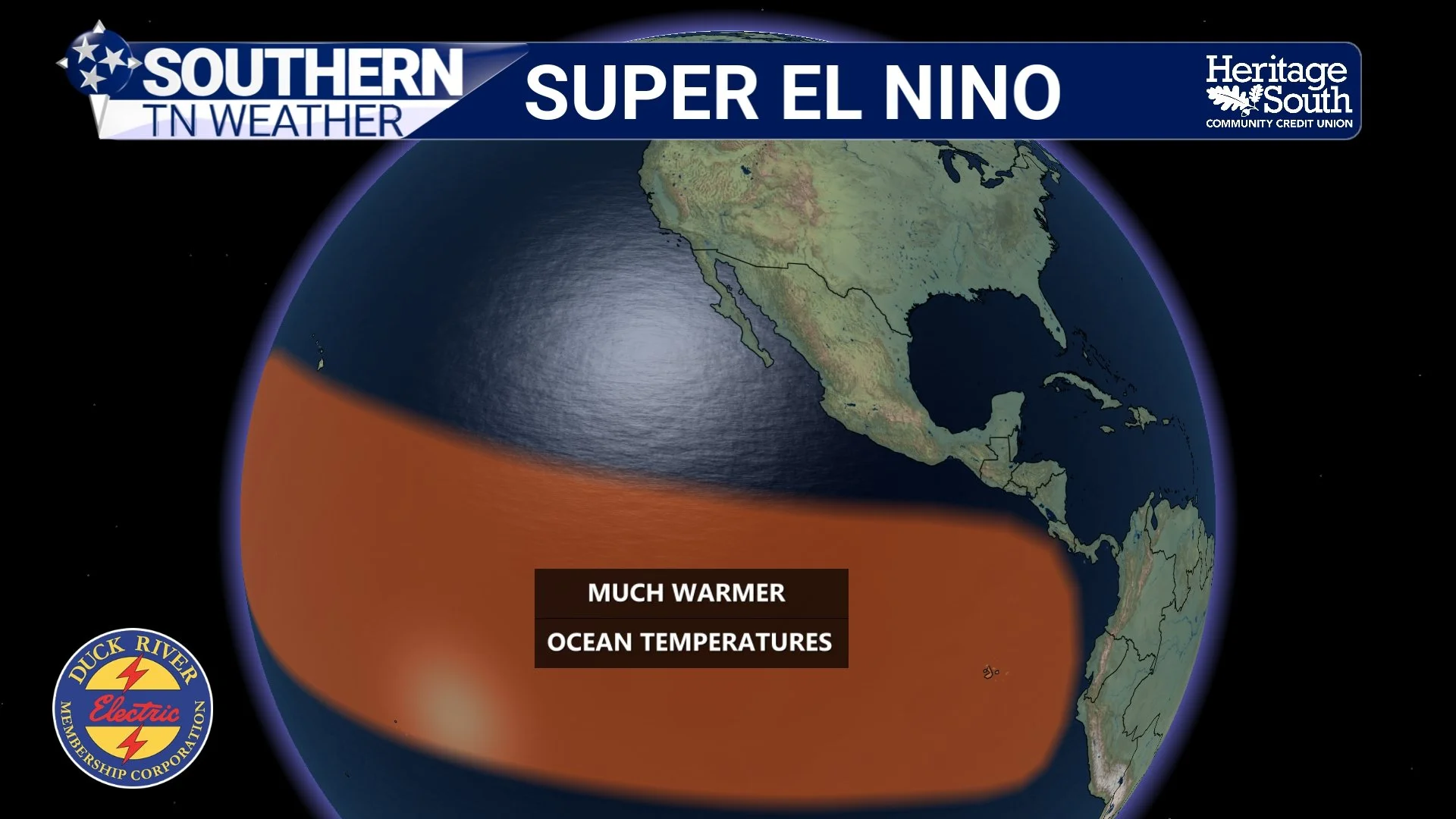
El Niño is one phase of a larger climate pattern called the El Niño-Southern Oscillation, or ENSO. At its simplest, El Niño occurs when portions of the tropical Pacific Ocean become unusually warm and those ocean changes become coupled with changes in the atmosphere above them. That last part is important. El Niño isn't simply a patch of warm ocean water. The tropical Pacific Ocean and atmosphere interact with one another. Changes in ocean temperatures can alter tropical thunderstorms, atmospheric pressure patterns and large-scale wind circulations. Those changes can then influence the jet stream and weather patterns thousands of miles away, including across North America.
Meteorologists pay especially close attention to an area of the equatorial Pacific known as the Niño 3.4 region, located roughly between 5° north and 5° south of the equator and 170°W to 120°W longitude. NOAA uses temperature departures in this region, along with atmospheric indicators, to monitor ENSO. There's also been an important change in how NOAA officially measures ENSO strength. NOAA now uses the Relative Oceanic Niño Index, or RONI, for official ENSO monitoring and prediction. Without getting too deep into the weeds, RONI accounts for the temperature of the tropical oceans as a whole rather than looking only at the absolute temperature departure in Niño 3.4. The familiar Oceanic Niño Index, or ONI, is still maintained for historical purposes.
Generally, NOAA's current strength categories break El Niño into weak, moderate, strong and very strong levels. A RONI value of +0.5°C to less than +1.0°C is weak, +1.0°C to less than +1.5°C is moderate, +1.5°C to less than +2.0°C is strong, and +2.0°C or greater is classified as very strong. Notice something missing from that list? There's no official “Super.”
EXPLAINER
So Where Did “Super El Niño” Come From?
“Super El Niño” is essentially an informal nickname that has become popular for exceptionally strong El Niño events, particularly those reaching the upper end of the historical record. Even the National Weather Service has specifically pointed out that the phrase is not an official NOAA term; the formal classification is very strong El Niño. That doesn't make the phrase completely meaningless. Scientists have occasionally used “super El Niño” in research to describe exceptionally intense events, although definitions can differ depending on the study. In everyday weather communication, however, the phrase has increasingly become shorthand for an El Niño that reaches or exceeds roughly the +2.0°C very-strong threshold.
And that's where things can get misleading. The word “super” naturally makes it sound as though we're forecasting some kind of meteorological monster that guarantees extreme weather everywhere. A Super El Niño must mean super storms, super rain, super snow and a super crazy winter, right? Nope. The strength measurement describes what's happening with the tropical Pacific ocean-atmosphere system. It does NOT tell us exactly what the weather will do at your house in Tennessee.
NOAA itself stresses that stronger ENSO events do not necessarily produce proportionally stronger local impacts. A stronger El Niño can increase confidence in some of the broad patterns historically associated with El Niño, but those patterns are still tendencies, not guarantees. That's a VERY important distinction. Think about El Niño as someone putting their thumb on one side of the atmospheric scale. A stronger event may push that scale harder in a particular direction, increasing the odds of certain broad weather patterns. But El Niño isn't the only thing touching the scale. The atmosphere has plenty of other players.
This El Niño Really IS Exceptionally Strong
Now that we've knocked down some of the hype, here's the interesting part: the actual forecast is remarkable enough without exaggerating it. NOAA officially has an El Niño Advisory in effect, and the September Climate Prediction Center discussion says El Niño is continuing to strengthen. During August, the Niño 3.4 sea-surface temperature anomaly had climbed to about +1.8°C, while portions of the eastern equatorial Pacific were more than 3°C above average. The ocean and atmosphere are also behaving consistently with a strengthening, coupled El Niño. The latest official NOAA strength probabilities are even more eye-catching. For the October-November-December period, NOAA assigns about a 98% probability of a very strong El Niño, meaning a RONI of at least +2.0°C. For November-December-January, the probability remains around 93%.
But there's an even more remarkable number buried in NOAA's discussion. The Climate Prediction Center currently estimates a 75% chance that the October-December RONI reaches at least +2.5°C, which would exceed previous El Niño events in NOAA's record dating back to 1950. Now THAT is significant. So when you hear people talking about an unusually powerful El Niño developing this year, there is absolutely legitimate science behind that discussion. The problem isn't saying this El Niño could become exceptionally strong. The problem comes when “Super El Niño” gets transformed into “therefore your winter will be extreme.”
Those are two very different statements.
A Stronger El Niño Does NOT Give Us a Winter Forecast
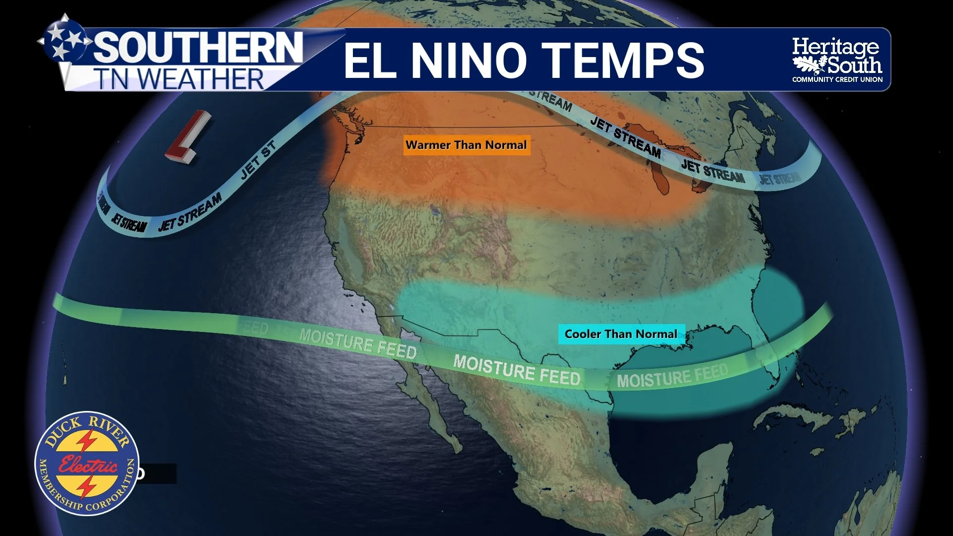
This is probably the most important takeaway from today's blog. El Niño changes probabilities. It doesn't write the forecast. During El Niño winters, changes in tropical Pacific thunderstorms and atmospheric circulation frequently alter the jet-stream pattern across North America. Certain parts of the United States consequently become more likely to experience particular temperature or precipitation patterns. But Southern Middle Tennessee isn't sitting directly over the tropical Pacific Ocean. By the time that signal reaches us, many other atmospheric patterns can modify, strengthen, weaken or temporarily overwhelm El Niño's influence. And history gives us a perfect example of why we shouldn't oversimplify things.
One of the strongest El Niño events on record occurred during 1982–83. You might assume that an exceptionally strong El Niño produced an exceptionally wet Tennessee winter. But an old NWS Nashville study found that Nashville actually finished that winter with only 92% of normal precipitation. Temperatures averaged 3.6°F above normal, while seasonal snowfall totaled just 1.5 inches. That's not me saying this winter will resemble 1982–83. Quite the opposite. It's an example of why one strong El Niño does not provide a template for another one.
Even NOAA's current outlook makes this point. A stronger El Niño increases the chances of experiencing some of the patterns typically associated with El Niño, but those outcomes are never guaranteed. Other large-scale atmospheric patterns will matter. The position and strength of the jet stream will matter. Shorter-term atmospheric oscillations will matter. Individual storm tracks will matter. And sometimes the atmosphere simply refuses to follow the nice, neat textbook diagram. That's weather for you. So does this El Niño tell us something useful about the upcoming winter? Absolutely.
Does it tell me how many inches of snow Shelbyville will receive, whether Christmas will be cold, or whether we'll have a major winter storm in January? Absolutely not. Anyone claiming to know those details in September has a crystal ball significantly better than mine. 😂
SUPER EL NINO TEMPS
Meanwhile, Summer Is Trying One More Comeback
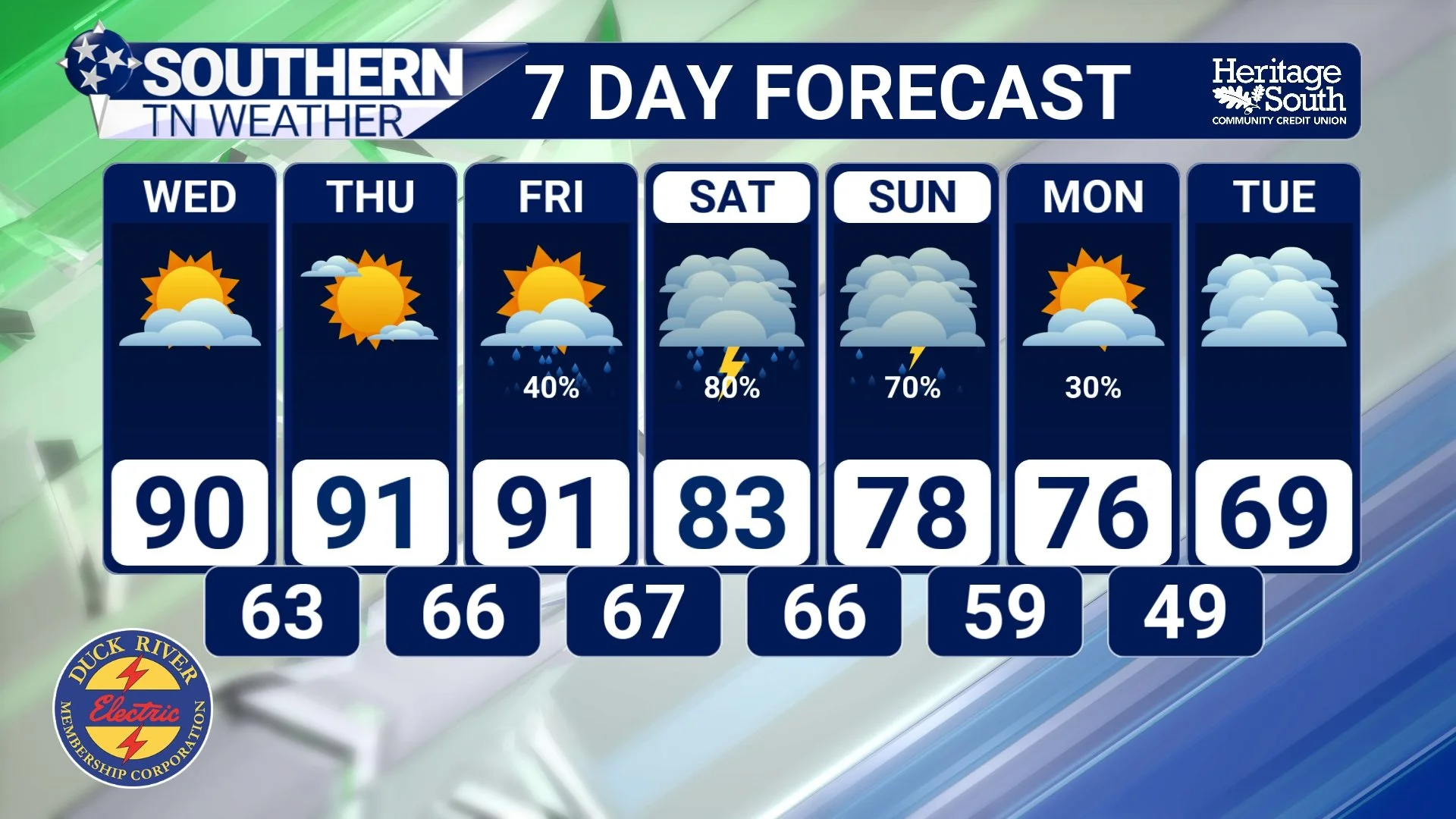
While we're talking about the upcoming winter, Mother Nature apparently decided to remind us that we're technically only a week removed from summer. After another comfortable start Tuesday morning, temperatures will climb quickly over the next few days. Highs should reach the mid to upper 80s Tuesday and Wednesday, with portions of Southern Middle Tennessee climbing into the upper 80s and lower 90s by Thursday and Friday. Humidity will also make a comeback. The atmosphere over us is exceptionally dry right now, but southerly winds will gradually transport Gulf moisture northward. Dew points should rise into the 60s by Thursday and Friday, making the air noticeably more humid. Some locations could experience a Moderate HeatRisk by late week, with Heat Index values potentially climbing into the middle and upper 90s.
Then comes the part we've been waiting weeks to talk about. RAIN. Moisture will increase dramatically heading into the weekend. Precipitable water values, essentially a measurement of how much moisture exists through the atmosphere above us, could approach or even exceed 2 inches by Saturday. That's above the 95th percentile for this time of year, an incredible turnaround from the exceptionally dry atmosphere sitting overhead right now.
Rain chances begin increasing Friday before becoming much more widespread Saturday into Sunday. NWS Nashville currently has widespread 60–70% rain chances from Saturday afternoon through Sunday morning, with ensemble guidance showing roughly a 50–60% chance of receiving more than 1 inch and a 20–30% chance of more than 2 inches. There are still questions about exactly how several approaching disturbances interact, so I'm still not interested in locking down exact rainfall totals. As we discussed in Monday's blog, pay attention to the signal, not the decimal point. And right now, the signal continues to look encouraging for a widespread, beneficial soaking rainfall.
Given how dry we've been, we could certainly use it.
STNWX 7-DAY FORECAST
The Bottom Line 🧾
🌊 “Super El Niño” is NOT an official NOAA classification. NOAA officially uses categories including weak, moderate, strong and very strong.
🌡️ A very strong El Niño corresponds to a RONI of +2.0°C or greater.
📈 This year's El Niño really is becoming exceptionally strong. NOAA says there is a greater than 90% chance of a very strong event during fall and winter 2026–27.
🤯 NOAA currently estimates a 75% chance that the October-December RONI reaches +2.5°C or greater, which would exceed previous events in the record dating to 1950.
❄️ A stronger El Niño does NOT automatically mean a more extreme, snowier, wetter or colder winter in Southern Middle Tennessee. ENSO changes the odds of certain patterns; it does not determine individual weather events.
🌡️ Back to our actual forecast, highs climb into the upper 80s and lower 90s by Thursday and Friday, with humidity increasing substantially.
🌧️ Rain chances begin increasing Friday before becoming widespread this weekend.
💧 Atmospheric moisture could climb above the 95th percentile by Saturday, supporting periods of locally heavy rainfall.
☔ Current ensemble guidance supports a good chance of a widespread soaking rainfall, although exact totals remain uncertain.
📰 Reminder: The Southern Tennessee Weather Blog, presented by Heritage South Community Credit Union, is updated Monday through Friday with fresh, locally tailored forecasts you can trust.
