
Drought Update: Severe Drought Expands Across Most of Southern Middle Tennessee

The Southern Tennessee Weather Blog is proudly presented by Heritage South Community Credit Union.
We Help When Others Won’t!
Visit https://www.heritagesouth.org/ today to see how HSCCU can help YOU!
Well, the newest Drought Monitor is out this morning, and unfortunately, we have taken another pretty significant step in the WRONG direction. Severe Drought has now expanded across much of Southern Middle Tennessee.
The newest analysis shows D2 Severe Drought covering a large portion of the southern tier of Middle Tennessee, while D3 Extreme Drought remains present in Bedford County. Extreme Drought is also now analyzed in northwest Wayne County and far southwest Perry County. Most of Middle Tennessee is experiencing at least D1 Moderate Drought, with only relatively small portions of the region remaining in the Abnormally Dry category. And this isn't a drought that has slowly been developing since spring or early summer. Much of what we're dealing with is the result of an incredibly rapid deterioration over the past several weeks. The latest drought assessment notes that most of Tennessee has experienced rapid drought development or worsening during the past four weeks, with no significant improvement occurring across the state.
The good news? For the first time in quite a while, we can actually talk about a legitimate rainfall event arriving within the next couple of days. And the timing couldn't be much better.
How Did Things Get THIS Bad So Quickly?
If your yard went from relatively healthy to looking like somebody took a flamethrower to it during September, you're certainly not imagining things. The combination of persistent heat and very little rainfall created nearly perfect conditions for rapid drought development. The newest national drought analysis specifically highlights Tennessee as one of several southern states where drought intensified again this week as unusually hot and dry weather continued. Across much of the South, temperatures ran roughly 6–12 degrees above average while very little rain fell. That's an important combination because drought isn't driven by rainfall alone. When temperatures become unusually hot, evaporation increases and plants lose additional moisture through transpiration. That means we're not simply failing to add water back into the ground through rainfall. We're simultaneously removing the moisture that's already there at a faster rate.
We've used the moisture savings account analogy several times throughout this drought, and September was basically an extended spending spree. Every hot, sunny day represented another withdrawal. Every day without rain meant no meaningful deposit was being made. Eventually, the account started running VERY low. The rainfall numbers illustrate just how quickly that happened. Over the past 30 days, most of West and Middle Tennessee has received 1.5 inches of rain or less, while some areas have received 0.75 inches or less. In general, rainfall has amounted to 50% or less of normal, with the driest areas receiving an incredible 5% or less of their normal rainfall during that period.
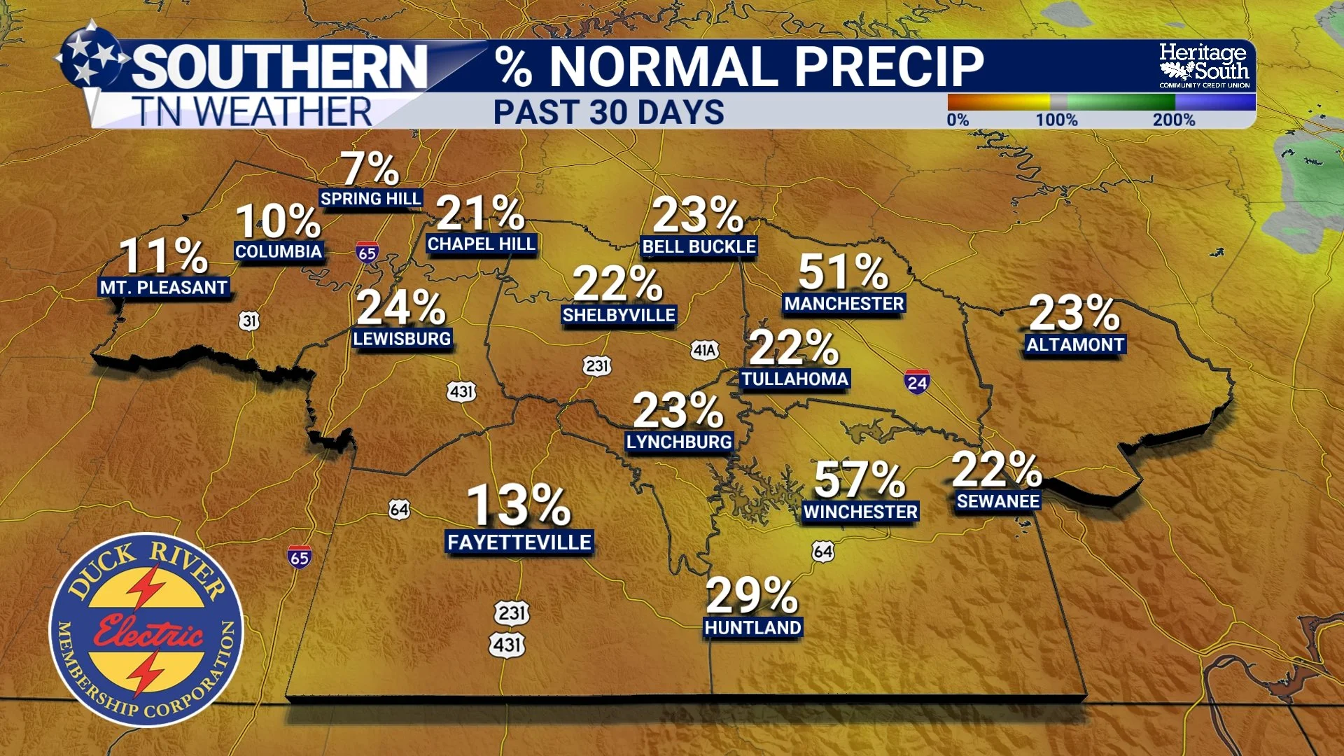
PERCENT NORMAL PRECIP - PAST 30 DAYS
And remember, the Drought Monitor isn't simply a map showing where it hasn't rained. The weekly analysis incorporates several indicators of how much moisture is actually available across the landscape. That's why an area doesn't automatically jump into Severe or Extreme Drought because it misses a few thunderstorms. D3 Extreme Drought encompasses Bedford County, with D2 Severe Drought now showing up elsewhere. D3 Extreme Drought is the second-highest category on the Drought Monitor scale, sitting only below D4 Exceptional Drought. Meanwhile, D2 Severe Drought now encompasses much more of Southern Middle Tennessee than it did only a week ago.
For a quick refresher, the scale goes: D0 Abnormally Dry → D1 Moderate Drought → D2 Severe Drought → D3 Extreme Drought → D4 Exceptional Drought. D0 isn't technically considered drought yet. Once we reach D1, we're officially in drought territory. D2, D3 and D4 represent progressively more serious moisture shortages and impacts. And unfortunately, we're now seeing more than just brown lawns.
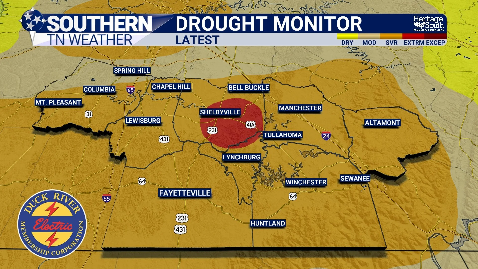
DROUGHT MONITOR - LATEST
The Drought Is Showing Up in Our Waterways
One of the more concerning changes in this week's drought information is what's happening with streamflow. Yes, streams and rivers naturally tend to run lower during this part of the year. But many monitoring locations across Middle Tennessee are now reporting below-normal to much-below-normal streamflows, and some locations have fallen to record-low flows for this time of year. That's an important distinction because drought exists on different timescales. Your lawn can turn brown relatively quickly when the upper few inches of soil dry out. That's a short-term response. But when streams, creeks, deeper soil moisture and water supplies begin responding, we're seeing the effects of that moisture shortage spread farther through the hydrologic system.
The latest assessment says some rivers and creeks are now well below normal because of the combination of seasonally low streamflow and the continued lack of rainfall. Soil moisture also remains a problem, while declining water levels in storage ponds are becoming a concern and livestock impacts are being reported. That's why I've repeatedly emphasized that one thunderstorm isn't going to fix this. If Shelbyville receives two inches of rain while Lewisburg, Lynchburg and Tullahoma receive a tenth of an inch, that's not meaningful regional drought relief. Likewise, if two inches falls in 45 minutes and a substantial portion immediately runs into ditches and creeks, we aren't getting the same benefit as we would from a slower, widespread soaking rainfall.
We need meaningful rainfall over a large area, preferably delivered at manageable rates over an extended period. And, FINALLY, the atmosphere may be preparing to give us something pretty close to that.
Rain Is FINALLY Coming... But How Much Will It Help?
Before we get to the rain, Thursday is going to provide one final reminder of the ridiculous heat we experienced through much of September. Highs will range from the lower 80s across the higher elevations to the lower and middle 90s elsewhere, with humidity continuing to increase as southerly winds transport Gulf moisture northward. Then the pattern starts changing tomorrow!
Rain chances will begin increasing as a weakening disturbance and cold front approach the region. Scattered showers and perhaps a few thunderstorms should develop during the day Friday, followed by more widespread rain Friday night and Saturday as the front slows considerably across the region. That slow movement could actually be VERY important for drought relief. Instead of a cold front racing through and giving us a narrow line of thunderstorms followed by immediate clearing, the boundary may stall near Southern Middle Tennessee while moisture continues flowing over it. That could support periods of showers lasting well into Saturday and potentially portions of Sunday.
Current forecasts support medium to high rain chances Friday through the weekend, with the heaviest rain generally expected from Friday afternoon into Sunday morning. The latest seven-day drought outlook calls for roughly 0.5–1.5 inches across West and Middle Tennessee, although localized totals could certainly be higher depending on where heavier rain develops. For drought relief, that's encouraging.
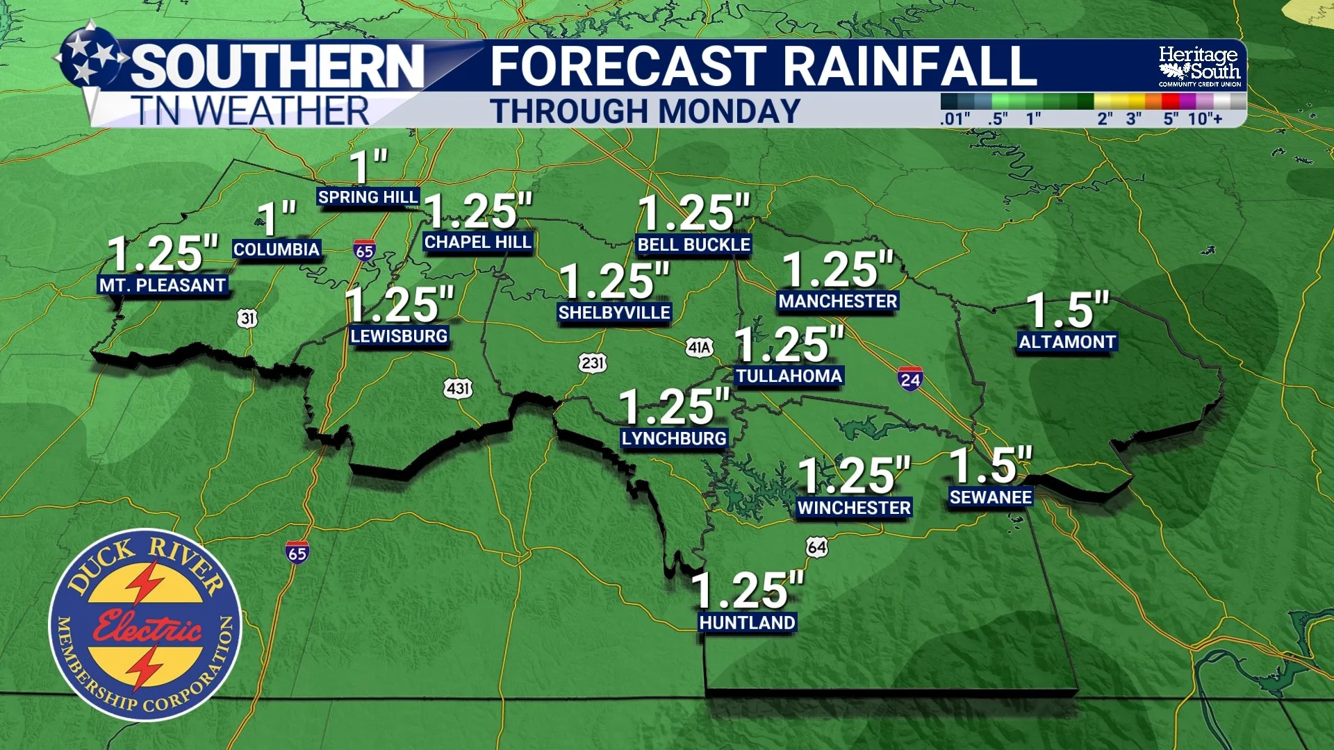
FORECAST RAINFALL - THRU MONDAY
As we discussed in Wednesday's blog, a slower rainfall spread across many hours gives water more opportunity to infiltrate into the soil instead of immediately becoming runoff. A widespread one-inch soaking rain could do considerably more good across Southern Middle Tennessee than a few isolated thunderstorms dumping three inches over tiny areas. But there's also a catch. Atmospheric moisture will become VERY high heading into the weekend, particularly across our area. Slow-moving showers or thunderstorms could produce locally heavy rainfall, and some storms may move at less than 10 MPH. That creates the possibility that certain locations receive too much rain too quickly, resulting in localized flash flooding. That's the strange reality of drought: we can desperately need rain and still get too much of it at once.
So how much will this weekend actually help? Potentially quite a bit in the short term. A widespread soaking rain could improve topsoil moisture, give lawns and vegetation some desperately needed water, replenish farm ponds to some degree and provide a noticeable boost to smaller streams and creeks. But I would NOT expect one weekend of rain to completely erase the drought. We've spent weeks digging this hole. It's going to take more than one shovel full of dirt to fill it back in.
The encouraging news is that the longer-range outlook continues to offer some hope. While drought is expected to remain in place during the next several weeks, the seasonal outlook favors above-normal precipitation across Tennessee from October through December, and drought conditions are expected to gradually improve if that wetter pattern develops. That doesn't guarantee a wet fall, nor does it mean every week will be rainy. It simply tilts the odds toward a wetter pattern over the season as a whole. For now, we'll start with this weekend!
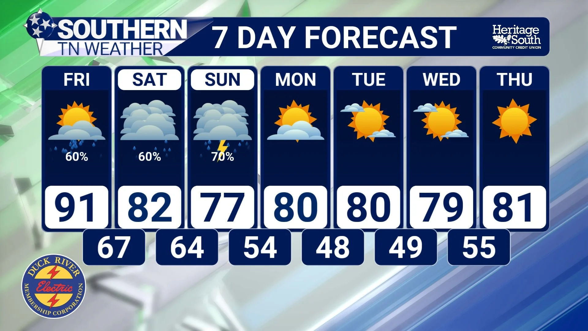
STNWX 7-DAY FORECAST
The Bottom Line 🧾
🌵 Severe Drought has expanded across much of Southern Middle Tennessee in the newest Drought Monitor.
🔴 Extreme Drought remains in Bedford County and is also present in northwest Wayne County and far southwest Perry County.
🟠 Most of Middle Tennessee is now experiencing at least Moderate Drought, with Severe Drought especially widespread across the southern tier.
📉 Most of Tennessee has experienced rapid drought development and degradation during the past four weeks.
🌧️ Most of West and Middle Tennessee has received 1.5 inches of rain or less during the past 30 days, with some locations receiving 0.75 inches or less.
🏜️ The driest areas have received only about 5% or less of their normal rainfall during that period.
🌊 Streamflows are below to much below normal at many locations, with record-low flows occurring in some places.
🐄 Low soil moisture remains a concern, while declining water in storage ponds is beginning to produce livestock impacts.
☔ Rain FINALLY returns Friday and continues into the weekend, with the heaviest rainfall currently favored Friday afternoon through Sunday morning.
💧 A widespread soaking rain would provide significant short-term drought relief, but one rainfall event is unlikely to completely erase an established drought.
🍂 Cooler and drier weather arrives behind the front Sunday night into next week.
👀 The longer-range outlook provides some encouragement, with above-normal rainfall favored overall for October through December and gradual drought improvement anticipated.
📰 Reminder: The Southern Tennessee Weather Blog, presented by Heritage South Community Credit Union, is updated Monday through Friday with fresh, locally tailored forecasts you can trust.
