
Why Has It Been So Dry? A Look at Tennessee’s Strange Spring Pattern

The Southern Tennessee Weather Blog is proudly presented by Heritage South Community Credit Union.
We Help When Others Won’t!
Visit https://www.heritagesouth.org/ today to see how HSCCU can help YOU!
Rain chances are FINALLY increasing across Southern Middle Tennessee this week, and honestly… it’s badly needed. After weeks of watching storms either weaken, split apart, or completely miss our area altogether, the atmosphere is finally beginning to shift into a more active pattern. Several systems moving through the Tennessee Valley between Tuesday night and late week could bring widespread rainfall totals between 1.5 and 2.5 inches for many communities across the region.
The severe weather threat still appears fairly low overall. While a few isolated stronger storms may develop Tuesday night into Wednesday morning along an approaching cold front, the better severe weather ingredients once again look displaced farther northwest. This setup appears much more favorable for beneficial rainfall than widespread hazardous weather. But this week’s rain also raises a bigger question that a lot of people have been asking lately: Why has it been so dry this spring? The answer is actually pretty fascinating… and it goes much deeper than simply “bad luck.”
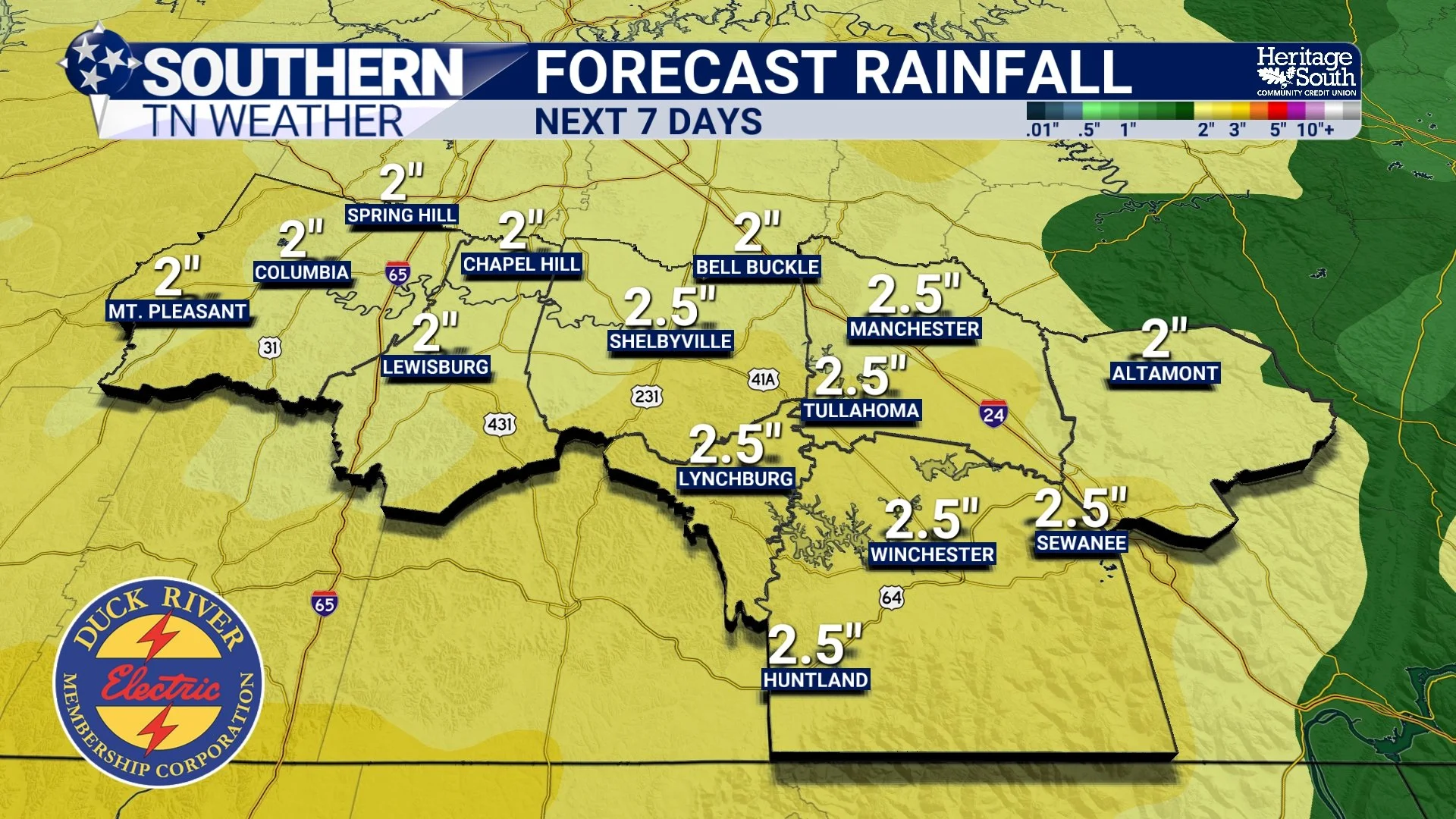
FORECAST RAINFALL - NEXT 7 DAYS
The Southeast Has Been Stuck Under Ridging
The biggest reason for the dry pattern has been persistent upper-level ridging across the eastern United States and western Atlantic. When meteorologists talk about “ridging,” we’re referring to an area of higher atmospheric pressure aloft associated with sinking air. That sinking motion suppresses cloud development, weakens storm systems, and often forces the jet stream farther north.
This spring, the Southeast has repeatedly found itself underneath or near the edge of these ridging patterns. Meanwhile, storm systems have frequently tracked across the Plains, Midwest, Ohio Valley, and Great Lakes instead of directly through Tennessee. We’ve essentially been sitting in what meteorologists sometimes call a “storm track dead zone” where the strongest dynamics and deepest moisture repeatedly stay displaced to our northwest.
That pattern has caused many cold fronts to weaken before arriving here. Others have stalled out completely before delivering meaningful rainfall. And some systems simply split apart as they encountered warmer, drier, more stable air across the Southeast.
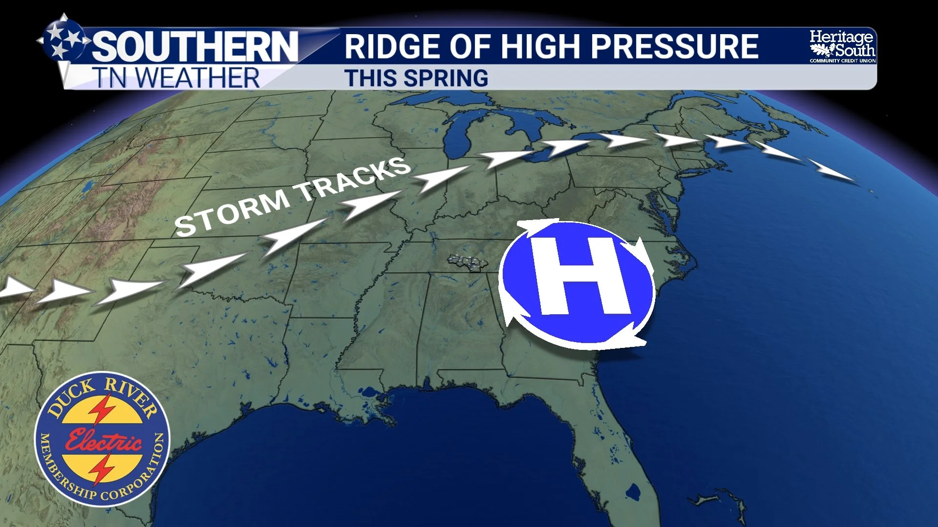
RIDGE OF HIGH PRESSURE - THIS SPRING
The Jet Stream Has Been Fighting Us
Another major player this spring has been the position of the jet stream. The jet stream is essentially a fast-moving river of air high in the atmosphere that helps steer storm systems. This spring, the more active southern branch of the jet stream has often remained weak or suppressed compared to what we typically need for widespread soaking rainfall across Tennessee.
Instead, much of the stronger upper-level energy has remained farther north. That matters because strong upper-level support helps create rising motion in the atmosphere. Rising air is critical for widespread clouds, organized rain, and thunderstorm development. Without consistent upper-level support overhead, many weather systems entering Tennessee have struggled to maintain intensity.
Soil Moisture Feedback Loops
One of the more overlooked parts of drought development is what happens AFTER conditions begin drying out. Dry soils heat up faster than moist soils. When the ground contains healthy moisture, some incoming solar energy gets used for evaporation. But when soils become very dry, more of that energy instead goes directly into heating the air.
That can actually reinforce hotter temperatures and deepen drought conditions further. Additionally, dry soils contribute less moisture back into the atmosphere through evaporation and plant transpiration. In simple terms, once an area becomes dry enough, it sometimes becomes harder for the atmosphere to help generate rainfall locally. This is one reason droughts can become self-sustaining during warmer months.
La Niña’s Lingering Influence May Have Played a Role
Large-scale ocean patterns may have also contributed. While the atmosphere has technically been transitioning away from La Niña conditions, lingering La Niña-type influences can still impact North American weather patterns for months afterward.
La Niña often favors stronger storm tracks farther north across the Ohio Valley and Great Lakes while promoting warmer and drier conditions across portions of the Southeast. That pattern aligns fairly well with what we’ve seen this spring. At the same time, sea surface temperature anomalies across the Gulf and western Atlantic have also likely helped strengthen ridging near the Southeast coast at times.
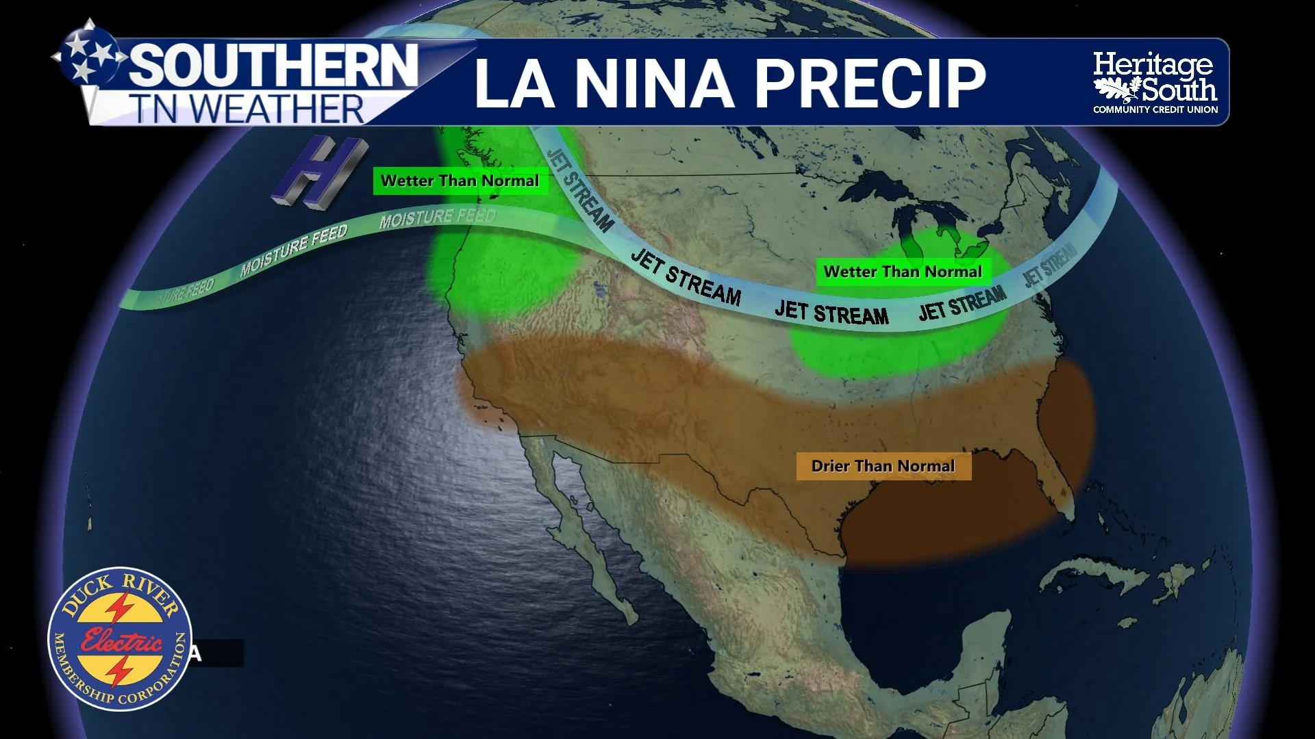
LA NINA PRECIP
Why This Week’s Pattern Is Different
Now, finally, the atmosphere appears to be loosening its grip a bit. A broad trough pattern is expected to establish itself across the eastern half of the country through much of this week. Unlike recent systems that weakened before arriving here, this setup should allow multiple disturbances and frontal boundaries to move directly through the Tennessee Valley.
At the same time, precipitable water values — or PWATs — are expected to increase substantially. PWAT is essentially a measurement of how much moisture exists throughout the atmosphere. Higher PWAT values mean the atmosphere becomes much more efficient at producing rainfall.
That’s why we’re becoming increasingly optimistic about widespread soaking rains this week. The highest rain chances currently appear to arrive Tuesday night through Wednesday, with additional rounds of showers and storms possible later Thursday into Friday as the stalled boundary lingers nearby.
Don’t Expect the Drought To Vanish Overnight
Even if many areas receive 2 inches or more of rainfall this week, the drought will not suddenly disappear. Drought recovery is a long-term process. Soil moisture, groundwater, streams, ponds, and reservoirs take time to recover, especially heading into the warmer portion of the year when evaporation rates increase rapidly.
Still… this upcoming pattern is absolutely a step in the right direction. And honestly, after the spring we’ve had, we’ll take every drop we can get.
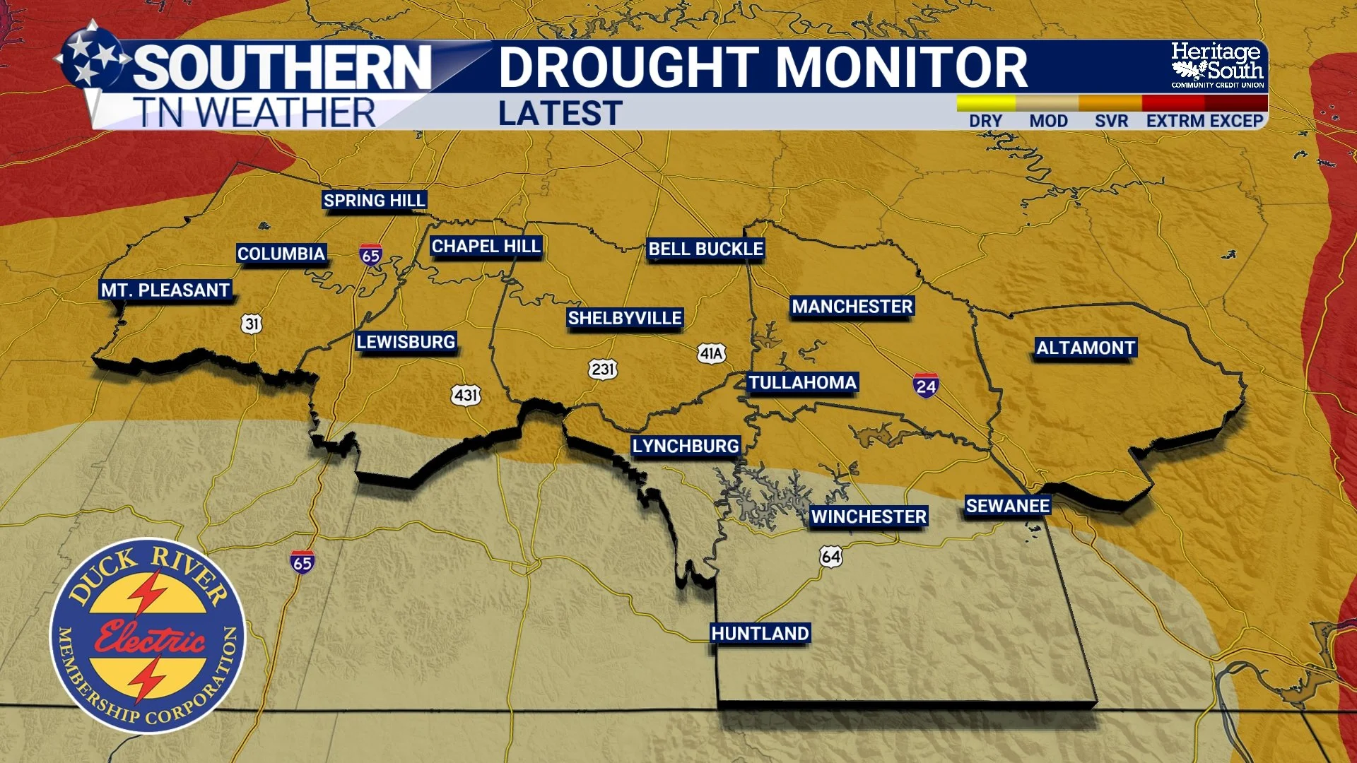
US DROUGHT MONITOR - LATEST
The Bottom Line 🧾
Southern Middle Tennessee is finally entering a wetter pattern this week.
Widespread rainfall totals between 1.5 and 2.5 inches are possible through late week.
The severe weather threat remains fairly low overall.
Persistent upper-level ridging has been one of the biggest drivers behind this spring’s drought.
Storm systems have repeatedly tracked northwest of Tennessee this spring.
Dry soils and warmer temperatures have helped reinforce drought conditions.
This week’s pattern finally looks favorable for meaningful rainfall across the region.
📰 Reminder: The Southern Tennessee Weather Blog, presented by Heritage South Community Credit Union, is updated Monday through Friday with fresh, locally tailored forecasts you can trust.