
Rain Finally Arrives!

The Southern Tennessee Weather Blog is proudly presented by Heritage South Community Credit Union.
We Help When Others Won’t!
Visit https://www.heritagesouth.org/ today to see how HSCCU can help YOU!
After weeks of talking about drought, dry lawns, and rain constantly missing Southern Middle Tennessee… the atmosphere is finally shifting into a much wetter pattern. And honestly, some locations may end up seeing TOO much rain over the next several days.
The overall severe weather threat still appears fairly low, but repeated rounds of showers and thunderstorms could create localized flooding issues through the remainder of the week, especially in areas that repeatedly get stuck underneath heavier storms.
A Summer-Like Setup Is Already in Place
Tuesday has felt much more like late June than mid May across Southern Middle Tennessee. Temperatures surged well into the upper 80s and lower 90s this afternoon while dewpoints climbed into the upper 60s and near 70 degrees. That combination has created a warm, humid, unstable atmosphere across much of the Tennessee Valley.
Despite the heat and humidity, most communities remained dry through the daytime hours thanks to weak subsidence and limited forcing overhead. In simple terms, the atmosphere has been unstable, but there has not been much available to actually trigger widespread storm development locally yet. That changes tonight.
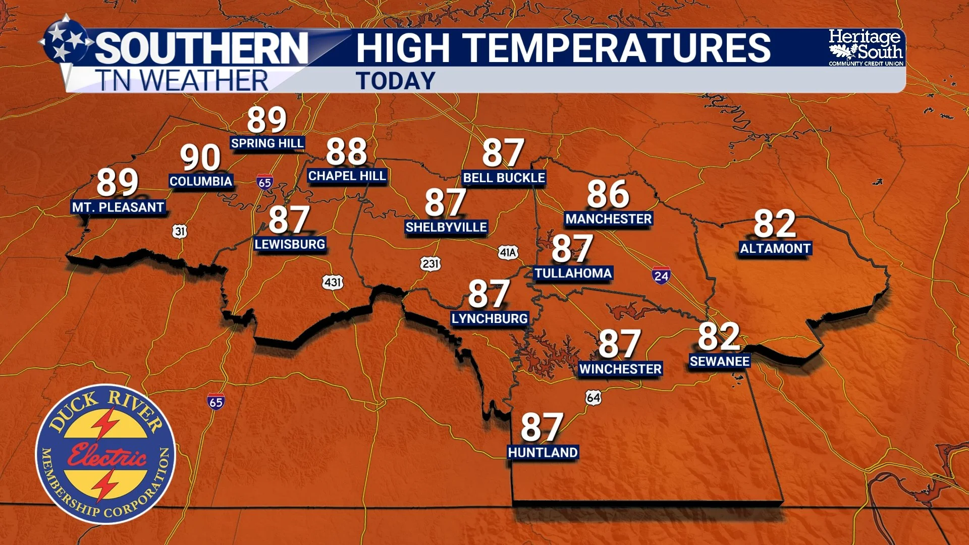
HIGH TEMPERATURES - TODAY
Storms Tonight: Mostly Weakening as They Arrive
A large cluster of storms currently developing farther west across portions of Missouri, Arkansas, and Louisiana will gradually move eastward tonight along an approaching cold front. As this activity moves toward Tennessee overnight, it will likely weaken some as it encounters a more stable environment locally. However, scattered showers and thunderstorms still appear likely to develop across portions of Middle Tennessee after midnight and continue into Wednesday morning. Right now, I think most of the activity should hold off here locally until around lunchtime or shortly after on Wednesday.
The overall severe weather threat tonight remains fairly low. Wind shear is weak, instability decreases overnight, and the better severe weather ingredients remain displaced farther west and northwest. That said, a few stronger storms could still produce gusty winds, lightning, and locally heavy rainfall.
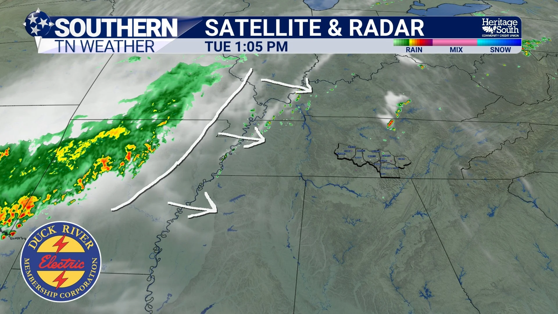
CURRENT SAT & RAD
Wednesday Is More About Rain Than Severe Weather
As we move into Wednesday and Thursday, the overall forecast focus shifts away from severe weather and increasingly toward heavy rainfall potential. The cold front moving into the region is expected to slow down and eventually stall near or just south of Tennessee. When fronts stall, they often become a focus for repeated rounds of showers and thunderstorms, especially during the afternoon and evening hours when daytime heating helps destabilize the atmosphere.
At the same time, atmospheric moisture levels remain unusually high for May. Meteorologists measure this moisture using something called PWATs, or precipitable water values. PWAT essentially measures how much moisture exists throughout the entire atmosphere above a location. Current forecast values between 1.5 and 2 inches are very high for this time of year and indicate the atmosphere will be extremely efficient at producing heavy rainfall.
In other words… when storms develop, they will be capable of dumping a LOT of rain in a short amount of time.
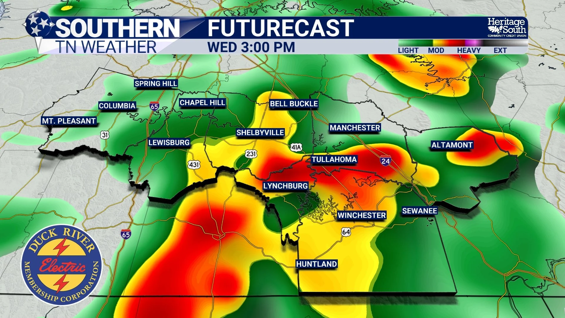
FUTURECAST - WEDNESDAY PM
Why Isolated Flooding Is Suddenly Becoming a Concern
This may sound strange after discussing drought conditions for weeks, but flash flooding can absolutely occur during droughts. Dry ground often struggles to absorb heavy rainfall efficiently at first. Instead of soaking into the soil immediately, water can rapidly run off into ditches, creeks, low-lying areas, and roadways.
Forecast guidance continues showing the possibility for “training” thunderstorms over portions of Middle Tennessee. Training occurs when multiple storms repeatedly move over the same area like train cars moving down a track. If that happens, localized rainfall totals could quickly climb well above the area average.
Right now, probabilities for at least 2 inches of rainfall by the weekend continue running fairly high across portions of the area, and some isolated locations could easily exceed that if repeated storms develop overhead. This does NOT appear to be a widespread major flooding setup at this time, but localized flash flooding and ponding of water on roadways absolutely become possible later this week.
The Severe Weather Threat Remains Low
The good news is that widespread organized severe weather still does not appear likely. Unlike classic spring severe weather setups, this pattern lacks strong wind shear. Wind shear is critical for organized supercells, tornadoes, and widespread severe storms.
Instead, this looks much more like a typical warm-season Tennessee pattern where slow-moving, moisture-rich thunderstorms become the primary concern. Could a few storms briefly pulse stronger during peak heating? Sure. But overall, heavy rainfall and localized flooding remain the bigger concern compared to tornadoes or widespread damaging winds.
The Pattern Stays Active Into the Weekend
Unfortunately for anyone wanting several consecutive dry days… the atmosphere may not fully settle down anytime soon. Weak disturbances are expected to continue riding northeastward along the stalled boundary through much of the week and possibly into the weekend. That means medium to high rain chances will likely remain in place each day, especially during the afternoon and evening hours.
Temperatures will cool somewhat after the front moves through, but highs will still generally remain in the low 80s with muggy conditions lingering.
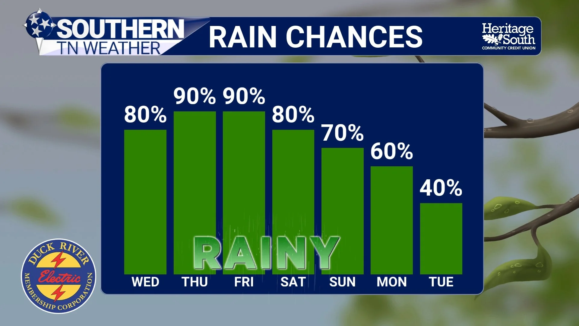
RAIN CHANCES - NEXT 7 DAYS
The Bottom Line 🧾
Showers and thunderstorms increase tonight into Wednesday across Southern Middle Tennessee.
The severe weather threat remains fairly low overall.
Heavy rainfall and localized flooding are becoming the bigger concern this week.
Atmospheric moisture levels are unusually high for May.
Some areas could receive more than 2 inches of rainfall by the weekend.
Repeated “training” storms may lead to localized flash flooding.
Rain and storm chances remain elevated through much of the week.
📰 Reminder: The Southern Tennessee Weather Blog, presented by Heritage South Community Credit Union, is updated Monday through Friday with fresh, locally tailored forecasts you can trust.