
Why Forecasting Summer Storms Is MUCH Harder Than Spring Severe Weather

The Southern Tennessee Weather Blog is proudly presented by Heritage South Community Credit Union.
We Help When Others Won’t!
Visit https://www.heritagesouth.org/ today to see how HSCCU can help YOU!
If the radar has felt chaotic lately, there’s actually a reason for that.
Southern Middle Tennessee is beginning to transition away from the classic spring severe weather pattern and into a much more summer-like setup. That means thunderstorms are becoming less organized, more localized, and MUCH harder to forecast perfectly from town to town.
Earlier this spring, storms were usually tied to stronger cold fronts and larger storm systems moving across the country. Those setups tend to produce widespread, organized rain and thunderstorm activity that’s easier to pinpoint ahead of time.
But now, the atmosphere is becoming increasingly driven by daytime heating, humidity, and tiny atmospheric details instead of big organized systems. That’s why some storms lately have looked like they just randomly exploded out of nowhere.
Tiny Atmospheric Details Are Driving The Forecast
One of the biggest challenges in this pattern is that very small-scale features are now controlling storm development. Things like leftover outflow boundaries from yesterday’s storms, breaks in cloud cover, localized humidity pockets, terrain differences, and subtle wind shifts are suddenly VERY important.
That’s also why rainfall totals have varied so dramatically from one community to the next. One town gets absolutely drenched while another nearby barely sees enough rain to wet the pavement.
Honestly, this is one of the hardest types of forecasting we deal with during the warm season because storms are no longer being controlled by one large organized weather system. Instead, they’re reacting to dozens of smaller atmospheric ingredients all interacting at once.
Why Northern Areas Have Been Quieter Today
Today is actually a really good example of this. Areas north of Interstate 40 have generally remained quieter overall, while southern portions of Middle Tennessee have seen better shower and thunderstorm development as of the time of this post.
That’s because slightly drier air from high pressure to our north is slowly trying to work southward into Tennessee. It’s not enough to completely eliminate storm chances, but it HAS been enough to suppress some thunderstorm development across northern counties.
Further south, deeper moisture remains in place, making it much easier for storms to bubble up during peak daytime heating. Those subtle moisture differences are making a huge difference in storm coverage right now.
Friday Into Saturday Still Looks Like The Wettest Stretch
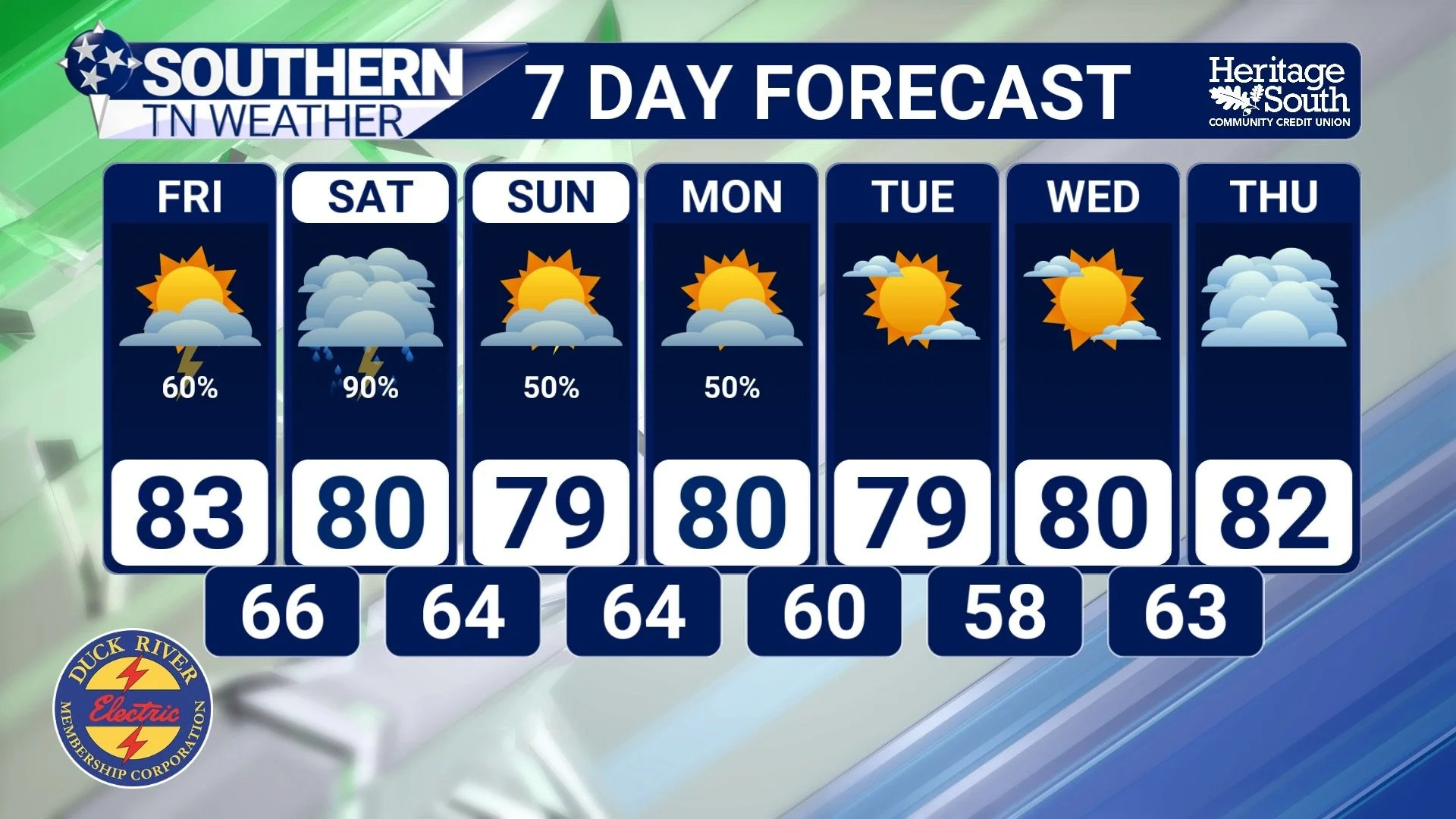
Before we fully transition into a drier pattern, we still have one more active period ahead of us Friday into Saturday.
Another disturbance moving through the Tennessee Valley will help increase rain and thunderstorm coverage area-wide, especially late Friday into Saturday. The atmosphere will remain very moisture-rich, meaning any stronger storms will still be capable of producing torrential downpours, gusty winds, and brief localized flooding concerns. The good news is this still does NOT look like an organized severe weather setup.
Storms should remain fairly disorganized overall, although a few stronger cells are certainly possible during the afternoon and evening hours. Most locations will likely receive around one-half inch to one inch of rainfall from Friday into Saturday, but isolated heavier amounts remain possible where storms repeatedly move over the same areas.
There Is Finally Light At The End Of The Tunnel
After what feels like weeks of endless humidity, clouds, and scattered storms, the atmosphere is FINALLY beginning to show signs of changing.
Forecast guidance continues showing drier and more stable air gradually filtering southward into Tennessee next week. Humidity levels should slowly become more tolerable, sunshine should become more common again, and rain coverage should become much more isolated overall. In other words, Southern Middle Tennessee is beginning to shift back toward a much more typical early summer weather pattern instead of the stagnant tropical setup we’ve been stuck in lately.
The Bottom Line 🧾
Scattered showers and thunderstorms continue through the weekend.
Friday into Saturday still appears to be the wettest period.
Storms are becoming more summer-like and less organized.
Rainfall totals will continue varying dramatically from town to town.
A few storms may produce gusty winds and localized flooding.
Drier and less humid weather is expected to gradually arrive next week.
📰 Reminder: The Southern Tennessee Weather Blog, presented by Heritage South Community Credit Union, is updated Monday through Friday with fresh, locally tailored forecasts you can trust.
