
The Pattern Starts Changing Next Week… Here’s Why

The Southern Tennessee Weather Blog is proudly presented by Heritage South Community Credit Union.
We Help When Others Won’t!
Visit https://www.heritagesouth.org/ today to see how HSCCU can help YOU!
After what feels like an eternity of clouds, muggy air, and nearly daily showers and thunderstorms, Southern Middle Tennessee may finally be getting closer to a legitimate pattern change. Now… before anybody gets TOO excited, we still have several more days of scattered rain and storm chances ahead of us through the weekend. But for the first time in awhile, forecast guidance is beginning to show a more meaningful shift in the overall atmospheric pattern across the eastern United States.
And honestly, this shift helps explain WHY we’ve been stuck in this repetitive weather setup for so long.
The Atmosphere Has Basically Been “Jammed”
Over the last week and a half, the weather pattern across North America has become unusually stagnant. Meteorologists call this an “Omega Block” pattern because the jet stream configuration resembles the Greek letter Ω (Omega). In simple terms, large-scale weather systems become trapped and move very slowly when this type of pattern develops.
Instead of cold fronts sweeping through quickly and clearing things out, the atmosphere essentially gets stuck in place. Storm systems slow down, moisture pools up, and the same weather repeats itself day after day. That’s exactly what we’ve been dealing with across Tennessee lately.
The Southeast has remained trapped underneath deep moisture while weak disturbances continuously rotate through the region. Every afternoon, daytime heating combines with all that humidity and leftover boundaries from previous storms to spark another round of scattered showers and thunderstorms. Then the whole process repeats itself the next day.
Why Rain Coverage Has Been So Random
One thing people often find frustrating in patterns like this is how inconsistent rainfall can be from town to town. One community gets absolutely drenched while another just a few miles away barely sees anything. That’s because we’re currently dealing with what’s known as mesoscale-driven convection.
Basically, thunderstorms are no longer being controlled by one large organized storm system. Instead, they’re forming along tiny atmospheric features like leftover outflow boundaries, pockets of sunshine, localized heating zones, and weak ripples in the upper atmosphere. Those smaller-scale details are nearly impossible to perfectly predict more than a few hours ahead of time.
That’s why forecast wording has repeatedly used phrases like “scattered” or “hit-and-miss.” And honestly… that wording is very accurate for this type of setup.
The Ground Is Changing Too
Another thing that’s beginning to evolve is the condition of the soil itself. Earlier in this wet pattern, the drought conditions actually helped reduce flooding concerns because the dry ground absorbed rainfall fairly efficiently. But after repeated rounds of storms over the past week, some areas (especially along and east of Interstate 65) have now received 6 to 8 inches of rainfall. As soils become more saturated, it becomes easier for newer storms to create runoff issues much quicker than they did earlier in the week.
That doesn’t mean widespread flooding is expected. Rivers and larger creeks are still handling things relatively well overall. However, localized flooding concerns are absolutely increasing, especially in areas where thunderstorms repeatedly move over the same locations during the afternoon and evening hours. Most of the area is well above-normal with precipitation over the past 30 days. Anything above 100% is considered above-normal.
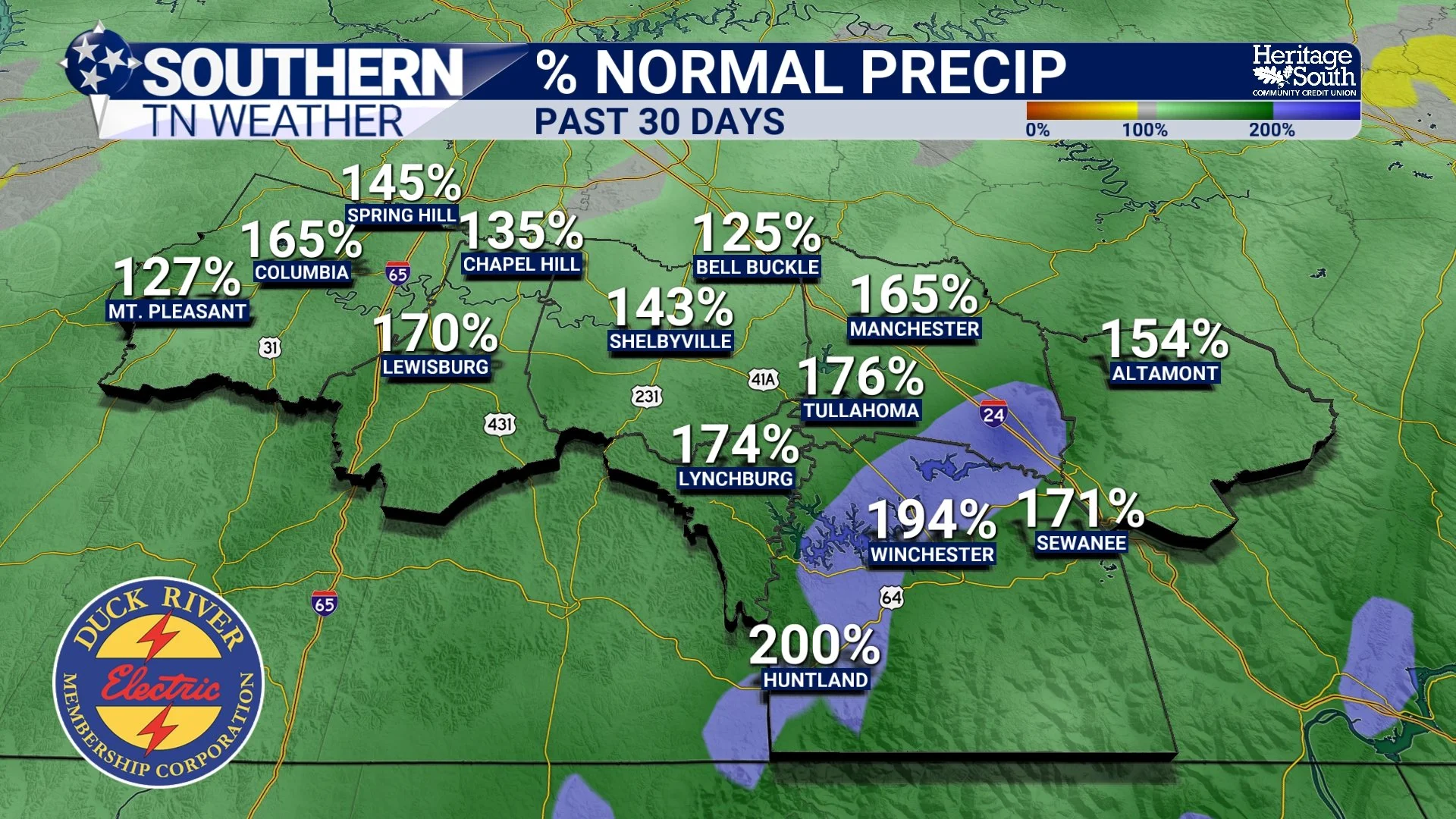
% NORMAL PRECIP - PAST MONTH
Fog Could Become A Bigger Story
One thing that hasn’t gotten talked about much lately is the growing fog potential overnight. This pattern is actually becoming increasingly favorable for areas of dense fog late at night and early in the morning.
Here’s why: During the day, thunderstorms dump huge amounts of moisture into the ground and leave behind saturated air near the surface. Then at night, winds weaken considerably while showers and storms gradually fade away. That combination allows moisture to condense near the ground very efficiently, especially in valleys, low-lying areas, and near rivers and creeks.
So while afternoons remain active with thunderstorms, the overnight and early morning hours may increasingly feature areas of locally dense fog over the next several days, including tonight.
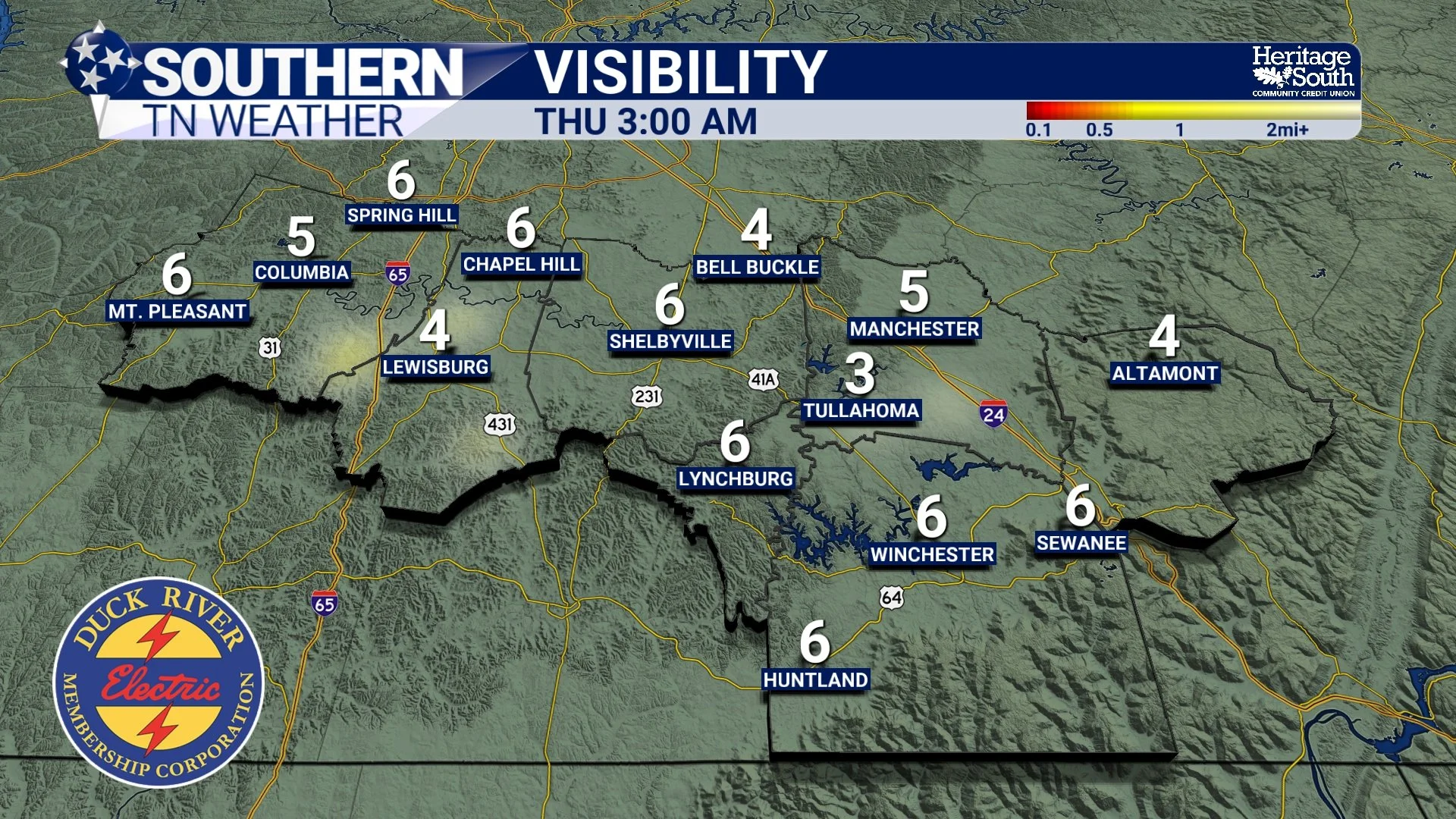
VISBILITY - THURSDAY MORNING
The Good News: The Pattern Is Slowly Breaking Down
There are finally signs that this sluggish pattern may begin loosening its grip by late weekend into next week. Forecast guidance shows the trough along the East Coast gradually deepening while drier northerly flow slowly begins filtering southward into Tennessee. That may not sound very dramatic, but it’s important.
Instead of endless southwest moisture transport feeding daily storms, the atmosphere will finally begin receiving drier air from the north. Humidity levels should gradually decrease, overnight temperatures may cool more efficiently again, and rain coverage should become much lower by early next week. In fact, forecast discussions are even mentioning something we honestly haven’t seen much lately: “Deep blue skies.” And after the last week and a half… Southern Middle Tennessee is probably ready for them.

RAIN CHANCES - NEXT 7 DAYS
The Bottom Line 🧾
Scattered showers and thunderstorms continue through the weekend.
A few storms may still produce gusty winds and localized flooding.
Rain coverage will remain hit-and-miss each afternoon and evening.
Areas along and east of I-65 remain most vulnerable to localized flooding concerns.
Overnight and early morning fog may become increasingly common.
A larger-scale pattern change is finally expected next week.
Drier air and lower humidity should gradually return by early next week.
📰 Reminder: The Southern Tennessee Weather Blog, presented by Heritage South Community Credit Union, is updated Monday through Friday with fresh, locally tailored forecasts you can trust.
