
Wet Weekend Ahead, But Signs Of Change Are Finally Emerging

The Southern Tennessee Weather Blog is proudly presented by Heritage South Community Credit Union.
We Help When Others Won’t!
Visit https://www.heritagesouth.org/ today to see how HSCCU can help YOU!
After what has felt like an endless stretch of clouds, humidity, and scattered thunderstorms, Southern Middle Tennessee is finally beginning to see hints of a pattern change. Now before everyone gets too excited, we still have an active weekend ahead of us. Showers and thunderstorms remain likely at times through Monday, and some locations will pick up additional beneficial rainfall.
But for the first time in several weeks, we’re starting to see evidence that the atmosphere is slowly preparing to move away from the stagnant pattern that has dominated much of May.
Late May Has Been Defined By One Thing: Moisture
If there has been one word that summarizes the past several weeks, it would be moisture. The atmosphere has repeatedly been supplied with deep Gulf moisture, allowing showers and thunderstorms to develop almost daily across Tennessee and much of the Southeast. This morning's weather balloon launched from Nashville measured precipitable water values near the 90th percentile for late May. In simple terms, there is still a tremendous amount of moisture available in the atmosphere. That’s why even ordinary thunderstorms have been capable of producing very heavy rainfall in a short amount of time.
The good news is that all of this rain has made a significant dent in drought conditions across Southern Middle Tennessee. Just a few weeks ago, many areas were dealing with severe drought conditions. Today, much of the region has improved considerably thanks to repeated rounds of rainfall.
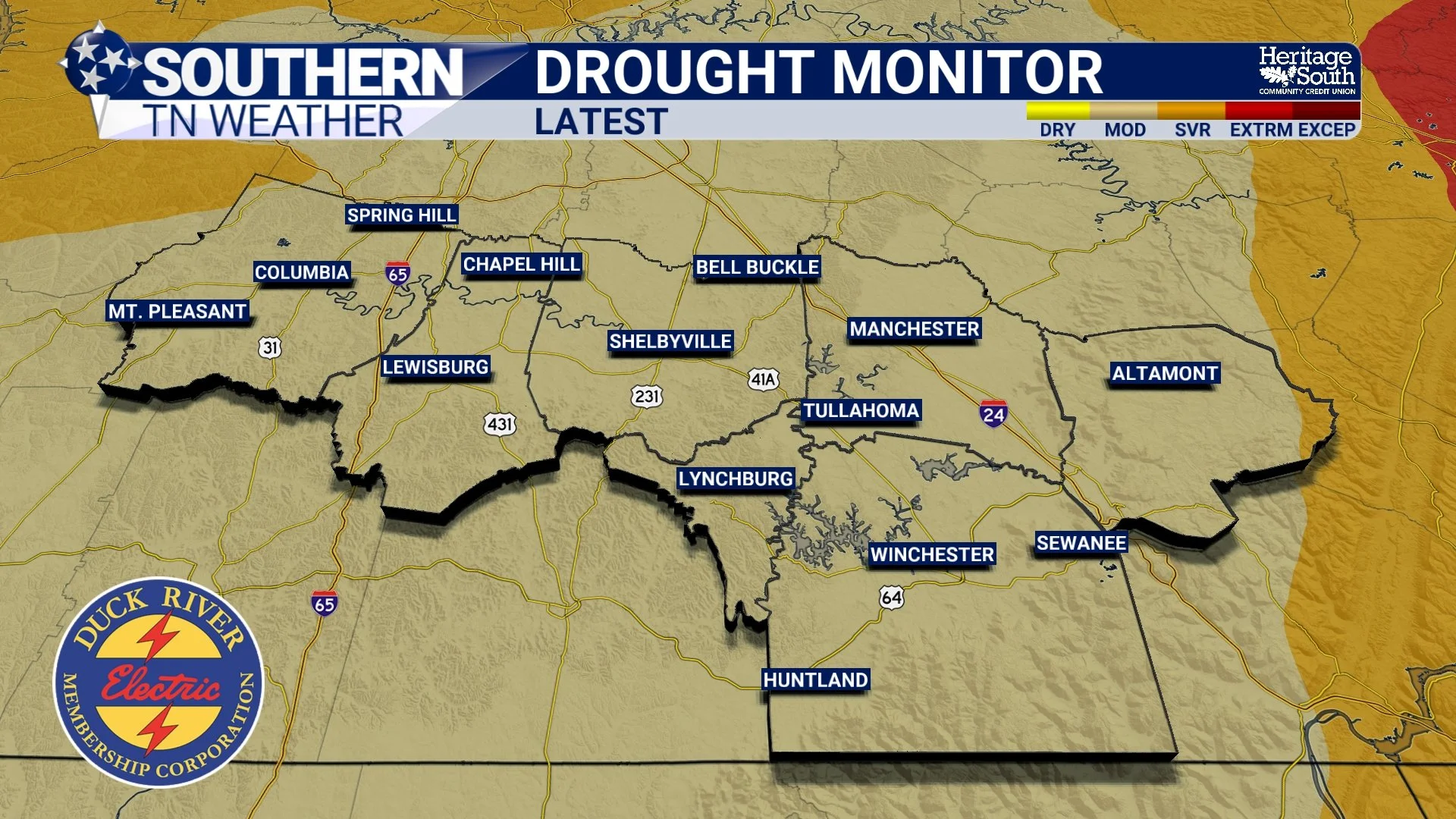
DROUGHT MONITOR - LATEST
Why The Weekend Still Looks Active
The atmosphere remains moisture-rich, and another disturbance moving through the Tennessee Valley will help keep showers and thunderstorms in the forecast through the weekend. Rain won't be continuous, and this certainly doesn't look like a washout from start to finish. In fact, many locations will experience several dry hours each day. However, whenever storms develop, they'll still have plenty of moisture available to work with.
The highest overall coverage of rain currently appears likely from this afternoon through Saturday. During this period, scattered to numerous showers and thunderstorms will be capable of producing brief heavy downpours, lightning, and occasional gusty winds. Organized severe weather is not expected, but a stronger storm or two cannot be completely ruled out. Additional rainfall totals through Sunday will generally range from one-half inch to one inch, although isolated locations could certainly see higher amounts underneath repeated storms.
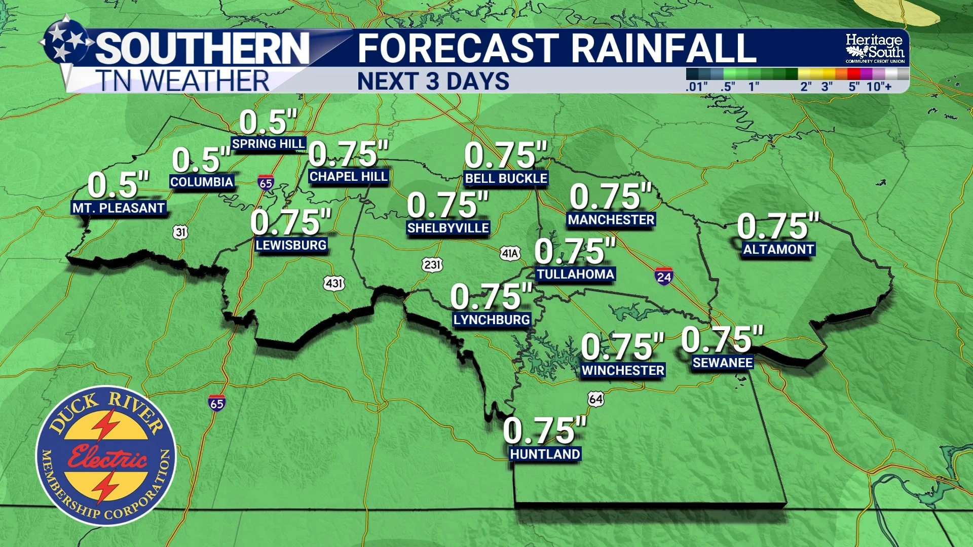
FORECAST RAINFALL - NEXT 3 DAYS
A Different Feel Is Coming
One of the more interesting parts of this forecast isn't necessarily the rain itself. It's where our air is coming from. For much of May, airflow has favored a continuous supply of humid Gulf air moving northward into Tennessee. That's one of the primary reasons the atmosphere has felt so tropical lately.
As we move into next week, high pressure building across the Great Lakes and Midwest will begin introducing somewhat drier air into the region. This won't happen instantly, but it should gradually become noticeable. Humidity levels should slowly become more tolerable, skies should become sunnier, and rain chances should become much more isolated compared to what we've experienced recently.
In other words, we're beginning to transition from a pattern dominated by widespread moisture to one that looks much more typical for early June.
June Is Looking More Like… June!
While no long-range forecast is perfect, current guidance suggests next week will feature a much more familiar early-summer setup. Instead of widespread daily rain chances, we'll likely return to more isolated afternoon storm chances with longer stretches of dry weather in between. Temperatures will remain near seasonal averages, generally topping out in the lower to middle 80s during the afternoon while nighttime lows settle into the 60s.
Perhaps most importantly, we'll finally get a break from the constant feeling that rain could develop at any moment!
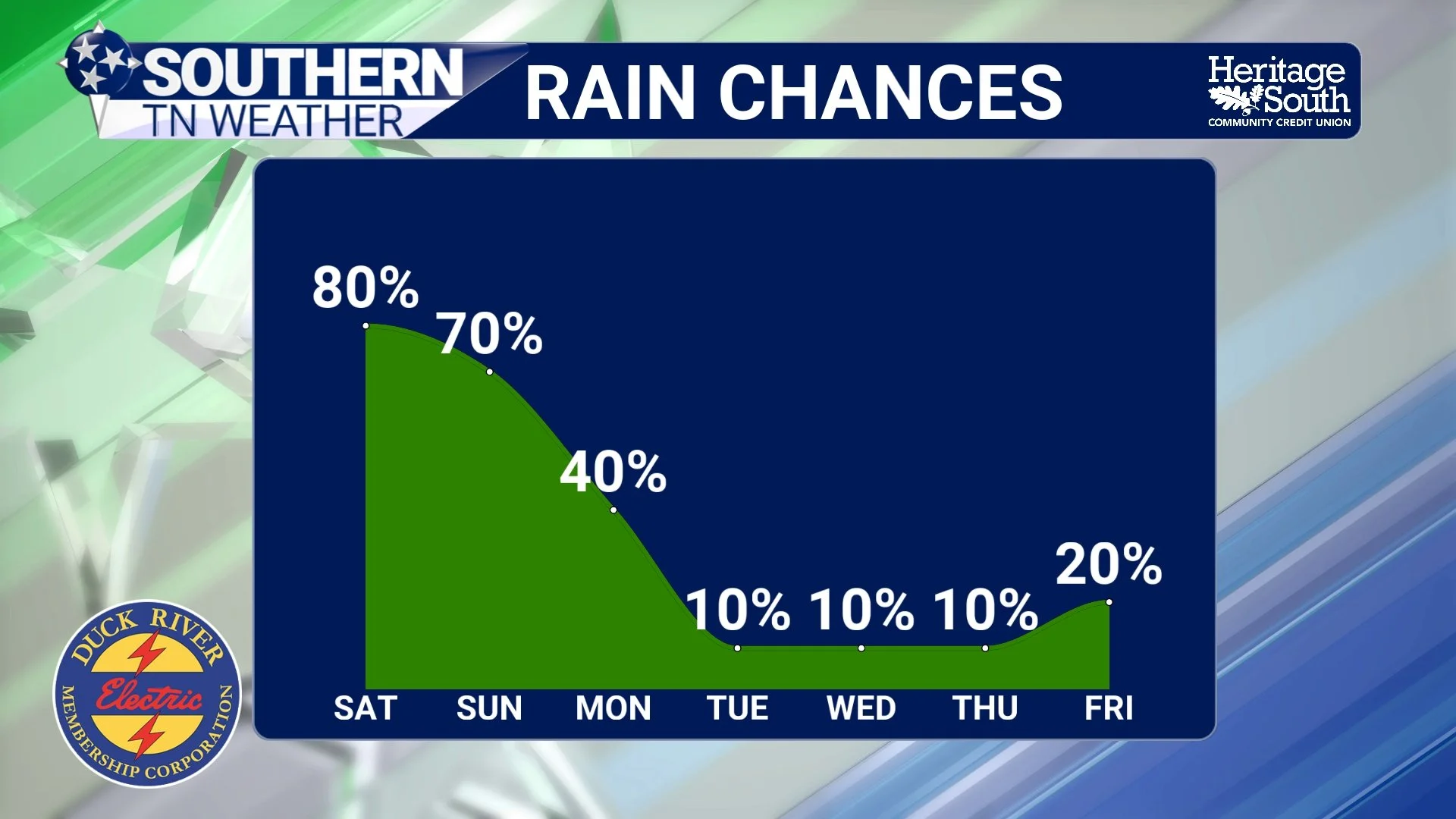
RAIN CHANCES - NEXT 7 DAYS
The Bottom Line 🧾
Scattered showers and thunderstorms remain likely through Monday.
The highest rain coverage is expected from Friday through Saturday.
A few storms could produce gusty winds and brief localized flooding.
Most locations will receive an additional one-half inch to one inch of rainfall through Saturday.
Recent rainfall has helped improve drought conditions across the region.
Drier air will gradually begin moving into Tennessee next week.
Early June is expected to feature a more typical summer weather pattern with fewer widespread rain chances.
📰 Reminder: The Southern Tennessee Weather Blog, presented by Heritage South Community Credit Union, is updated Monday through Friday with fresh, locally tailored forecasts you can trust.
