
Why Does Fall Weather Arrive in “Waves”?

The Southern Tennessee Weather Blog is proudly presented by Heritage South Community Credit Union.
We Help When Others Won’t!
Visit https://www.heritagesouth.org/ today to see how HSCCU can help YOU!
It's September 14th. We're about a week away from the official beginning of astronomical fall. Pumpkin spice has invaded every store within a 50-mile radius, football is back, and Tennessee's trees are already responding to shorter days. Meanwhile, Southern Middle Tennessee is out here sweating through temperatures in the middle and upper 90s, with Heat Index values about to climb as high as 105–109° in some locations.
So... where in the world is fall? 😂 The answer is that fall doesn't really “arrive” on one particular day. It arrives in waves. And what we're experiencing right now is actually a great example of how the atmosphere transitions from summer into autumn.
The Calendar Changes Faster Than the Atmosphere
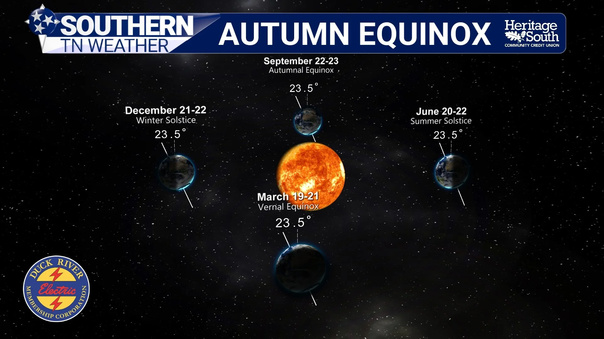
Meteorological fall officially began September 1st, while astronomical fall begins with the autumnal equinox next week. Neither date, however, flips some giant atmospheric switch from summer to fall. Instead, September is very much a transition month. As we move deeper into late summer and early fall, the Northern Hemisphere receives progressively less solar energy. The sun takes a lower path across our sky, daylight continues getting shorter, and nights become longer. All of that gradually tips the scales toward cooler weather.
But gradually is the important word. The land, atmosphere and especially the enormous bodies of water surrounding North America don't instantly lose the heat accumulated during summer. There's a seasonal lag between the maximum amount of incoming solar energy around the summer solstice and when our temperatures finally begin responding in a major way. That's why June 21st isn't typically our hottest day of the year, and it's also why September 21st doesn't suddenly mean highs in the 70s and mornings in the 40s.
Our average temperatures are trending downward by this point in September, but the atmosphere is still perfectly capable of producing summertime heat when the right weather pattern develops. And unfortunately, we've got a pretty impressive example sitting over us right now.
AUTUMN EQUINOX
It's Really a Battle Between Summer and Fall
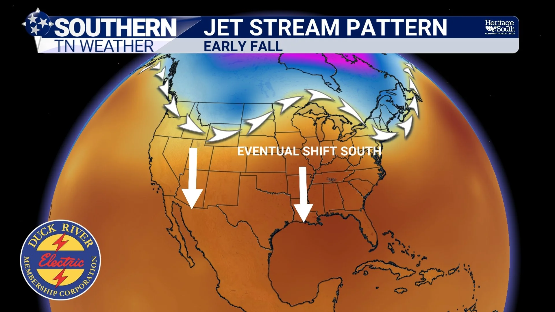
If you look at the atmosphere across North America during September and October, you can almost think of summer and fall battling for territory. During the heart of summer, the jet stream is generally displaced farther north, while large ridges of high pressure frequently dominate the southern United States. Those ridges are associated with sinking air, fewer clouds and plenty of heat.
As autumn progresses, the temperature difference between the increasingly cold northern latitudes and the still-warm southern United States begins strengthening. The jet stream gradually becomes more active and starts making more frequent dips farther south. Those dips can help send cooler Canadian air masses and stronger cold fronts into our part of the country. But early in the season, those cooler pushes don't always stick around. A cold front might sweep through Southern Middle Tennessee and give us a couple of gorgeous mornings in the 50s, lower humidity and afternoon highs in the 70s or 80s. Everybody starts decorating the porch, opening the windows and declaring summer officially dead.
Then the upper-level ridge rebuilds. Southerly winds return, temperatures climb back into the upper 80s or 90s, humidity increases, and Tennessee collectively realizes we've been tricked again. That's basically what people jokingly call “False Fall.”
There isn't an official meteorological definition for False Fall, but the idea describes our transitional weather pretty well. The first cool air mass of September doesn't mean the summertime pattern is finished. It simply means we've experienced one of those increasingly frequent waves of fall. As we move through late September and October, those waves typically become stronger, cooler and longer-lasting until eventually the summertime pattern has a much harder time fighting back.
TYPICAL JET STREAM PATTERN - EARLY FALL
Why Can We Still Get THIS Hot in Mid-September?
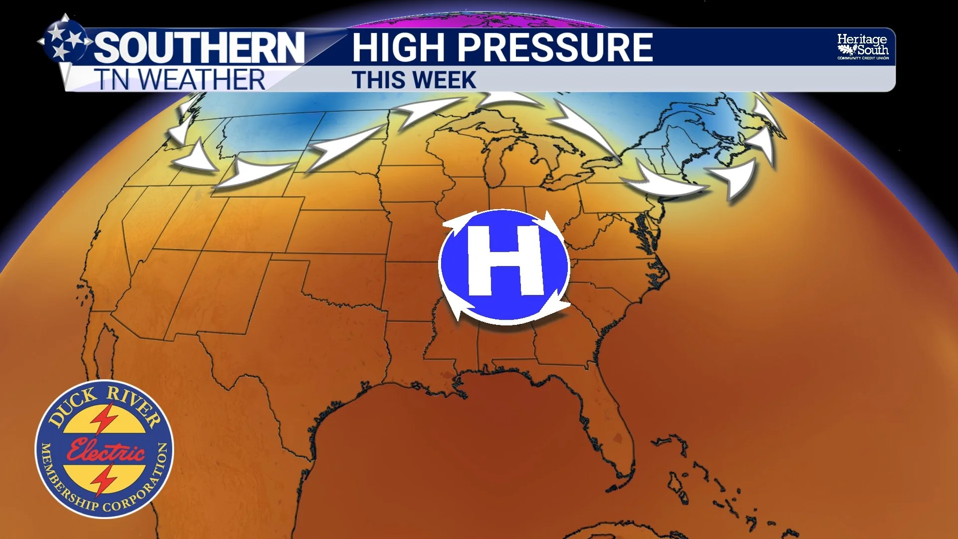
That brings us to the ridiculous heat we're experiencing this week. A broad and strengthening ridge of high pressure is dominating much of the eastern United States. In the upper atmosphere, that ridge is essentially creating a large area of sinking air. As air sinks, it compresses and warms. That sinking motion also makes it harder for clouds and thunderstorms to develop, allowing sunshine to do its thing for most of the day. Combine that with very warm air already in place and plenty of humidity near the surface, and you've got the recipe for a legitimate late-season heat wave. Tuesday and Wednesday look like the worst of it.
A Heat Advisory is in effect Tuesday and Wednesday for much of Middle Tennessee west of the Cumberland Plateau, with afternoon Heat Index values potentially reaching 105–109°. Actual temperatures will climb well into the 90s, and a few locations could flirt with 100°.
Across Southern Middle Tennessee, temperatures will generally reach the middle and upper 90s Tuesday and Wednesday. Dew points in the upper 60s and lower 70s will add enough humidity to make it feel considerably hotter, with some communities potentially reaching or exceeding a 105° Heat Index. So even though the September sun isn't as strong as it was during June or July, the overall weather pattern can still overwhelm that seasonal disadvantage and produce some serious heat.
HIGH PRESSURE - THIS WEEK
Eventually, Fall Starts Winning More of the Battles
The good news is that the scales will continue tipping in fall's favor. Every day we lose a little more daylight. Nights become longer, the sun angle continues lowering, northern air masses become progressively colder, and the jet stream becomes increasingly capable of delivering meaningful cold fronts farther south. Eventually, a front comes through and temperatures don't immediately rebound into the middle 90s.
Then another front arrives. And another. By that point, instead of asking when fall will finally show up, we'll probably be complaining that it's 42° outside at 6:00 AM. Because we're never satisfied! That's why I wouldn't look at this week's heat as evidence that fall isn't coming or that the seasons are somehow running behind. This back-and-forth is part of the transition itself.
The atmosphere rarely moves cleanly from one season into another. September and October are often a tug-of-war between lingering summertime ridges and increasingly potent autumn cold fronts. And interestingly enough, there are at least some signs that our next wave of fall may be lurking on the horizon.
So... When Is Our Next Wave of Fall?
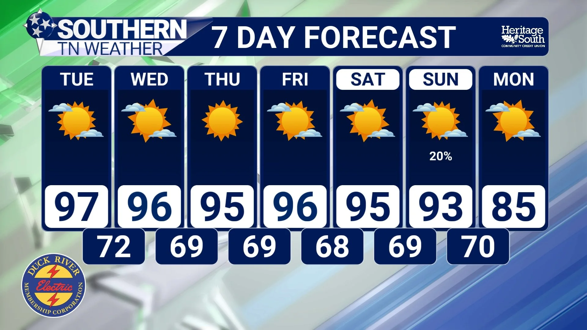
Unfortunately, you're going to have to sweat for a while first. Today will be hot with highs generally in the middle 90s under mostly sunny skies. Rain chances are extremely low, although a very isolated shower can't be completely ruled out. Tuesday looks like the hottest day of this stretch. Highs climb into the middle and upper 90s, with a few locations potentially approaching 100°. Combined with the humidity, Heat Index values could reach 105–109°, especially across areas west of the Cumberland Plateau. A Heat Advisory is in effect for much of the region. Wednesday doesn't offer much relief. Temperatures remain well into the 90s with dangerous afternoon heat continuing. A few isolated showers or thunderstorms may attempt to develop around the higher terrain farther east, but for most of Southern Middle Tennessee, meaningful rain chances remain extremely low.
Thursday through Saturday looks largely like more of the same: hot, humid and mostly dry. Afternoon highs remain in the 90s, with Heat Index values around 100° possible on multiple days. An isolated shower can't be completely ruled out, but widespread beneficial rainfall isn't expected. Things become more interesting by Sunday into Monday. The ridge responsible for this heat should finally begin weakening as an upper-level trough approaches from the west. That should allow rain chances to increase somewhat while temperatures begin a gradual decline.
Exactly how quickly that happens is still uncertain. Forecast guidance disagrees somewhat on how successfully the approaching front will push southward. If it makes a stronger push into our area, we could see increasing rain chances followed by a more noticeable break from the heat. If it stalls farther north, summerlike temperatures could hang around longer. We’re increasingly optimistic that temperatures could trend closer to normal by next weekend, and there's at least the possibility that we finally get a more legitimate autumn cold front around the time of the fall equinox.
We're still several days away, so don't break out the hoodie just yet, but perhaps our next wave of fall is finally beginning to show itself on the weather maps.
STNWX 7-DAY FORECAST
The Bottom Line 🧾
🍂 Fall doesn't arrive all at once. The transition from summer to autumn typically happens in waves.
☀️ Shorter days and a lower sun angle gradually favor cooler weather, but the atmosphere retains plenty of summertime warmth during September.
🌬️ As fall progresses, the jet stream becomes increasingly capable of sending cooler air masses and stronger fronts southward.
🎃 Early cool spells can quickly be followed by another surge of heat, giving us the unofficial “False Fall.”
🔥 A strong ridge of high pressure is responsible for this week's late-season heat.
🌡️ Tuesday and Wednesday look brutally hot, with highs in the middle and upper 90s and Heat Index values potentially reaching 105–109°.
☀️ Rain chances remain extremely low through much of the week.
🌦️ Rain chances should begin increasing somewhat Sunday into Monday as the ridge weakens.
📉 A gradual cooldown is possible beginning Sunday and continuing into next week.
🍁 There are encouraging signs of a potentially stronger autumn cold front by next weekend, but it's still too early to lock down exactly how cool we'll get.
📰 Reminder: The Southern Tennessee Weather Blog, presented by Heritage South Community Credit Union, is updated Monday through Friday with fresh, locally tailored forecasts you can trust.
