
Relative Humidity: The Moisture Measurement That Doesn't Tell the Whole Story

The Southern Tennessee Weather Blog is proudly presented by Heritage South Community Credit Union.
We Help When Others Won’t!
Visit https://www.heritagesouth.org/ today to see how HSCCU can help YOU!
You've probably seen this happen countless times. You wake up on a humid summer morning, check your weather app, and see the relative humidity sitting at 90 or even 100%. By the middle of the afternoon, it's blazing hot outside, you're sweating the second you walk out the door, and yet the relative humidity has somehow fallen to 40 or 50%. So... where did all that moisture go?
In many cases, it didn't go anywhere. Relative humidity is one of the most familiar weather measurements, but it's also one of the easiest to misunderstand. Despite its name, relative humidity doesn't simply tell us “how much moisture is in the air.” Instead, it tells us how close the air is to saturation relative to its current temperature.
That last part is extremely important. Temperature and relative humidity are closely connected, which means relative humidity can change substantially throughout the day even when the actual amount of moisture in the atmosphere hasn't changed nearly as much. And on a week like this one, when Southern Middle Tennessee is dealing with temperatures in the upper 90s and Heat Index values well into the triple digits, understanding that difference becomes especially useful.
What Does 50% Humidity Actually Mean?
One of the biggest misconceptions about relative humidity is that 50% means the atmosphere is simply “half full” of moisture. That's not really how it works. Relative humidity compares the amount of water vapor present with the amount associated with saturation at the current temperature. As temperature increases, the saturation vapor pressure increases substantially. That means the same amount of water vapor can produce very different relative humidity values depending on how warm or cool the air is.
Here's a good example. Imagine waking up around sunrise with a temperature of 70° and a dew point very close to 70°. The air is nearly saturated, so relative humidity could be close to 100%. That also helps explain why dew or fog is more common around sunrise, when temperatures are typically at their lowest. Now let the sun come up and warm that same air into the 90s. Even if the amount of water vapor doesn't change dramatically, the air is now much farther from saturation at its warmer temperature. As a result, the relative humidity drops.
You might go from 95% relative humidity early in the morning to 45% during the afternoon without remotely losing half of the moisture in the atmosphere. This is also why relative humidity usually follows a fairly predictable daily cycle. It tends to rise overnight as temperatures fall, peaks around the coolest part of the morning, and then falls as temperatures climb during the afternoon. So when your Southern Tennessee Weather app says the relative humidity is only 45% at 3:00 PM, that doesn't automatically mean it's dry or comfortable outside. In the middle of a Southern Middle Tennessee summer, it can still be downright muggy.
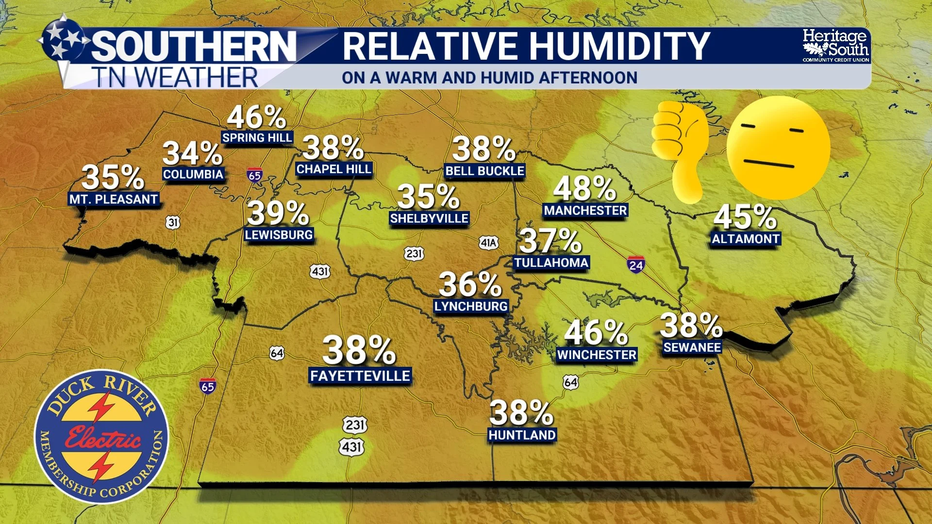
RELATIVE HUMIDITY
This Is Where Dew Point Tells Us More
If I want to know how much moisture is actually in the atmosphere or how muggy it's likely to feel outside, dew point is usually the number I'm watching. The dew point is the temperature to which air would need to cool for it to become saturated, assuming its moisture content remains essentially unchanged. Unlike relative humidity, dew point doesn't automatically plunge just because the afternoon temperature shoots upward.
For example, imagine it's 97° outside with a dew point around 70°. Your weather app may show a relative humidity value that doesn't look particularly impressive, but that 70° dew point immediately tells us there's plenty of moisture hanging around. And your body will probably confirm that within about 30 seconds of walking outside.
As a general rule, dew points in the 50s tend to feel fairly comfortable. Once we climb through the 60s, the air becomes increasingly humid, and dew points around 70° or higher are when that classic sticky Southern humidity really starts making itself known. This is one reason you've probably noticed me talking about dew points quite a bit during humid weather. Relative humidity isn't wrong or useless. Dew point and relative humidity are simply telling us different things. Relative humidity tells us how close the atmosphere is to saturation at its current temperature. Dew point gives us a much better idea of the actual moisture content and, as a result, how muggy the air is likely to feel.
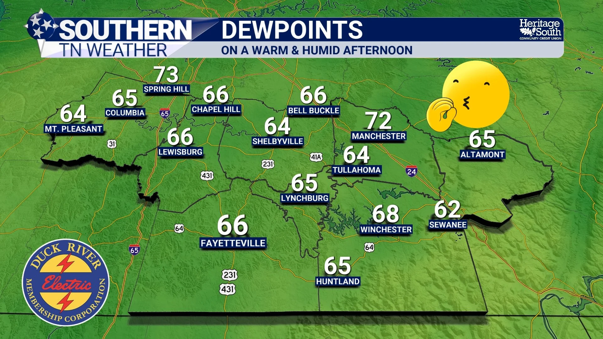
DEW POINTS
Relative Humidity Is Still VERY Important
After spending half the blog explaining its limitations, I don't want anybody walking away thinking meteorologists should toss relative humidity into the trash can… It's an incredibly useful measurement! Knowing how close the atmosphere is to saturation is important when forecasting fog, dew, clouds and precipitation. Meteorologists also examine relative humidity at different levels of the atmosphere, not just at the ground. A layer of very high relative humidity several thousand feet above us, for example, can provide clues about where clouds may develop.
Relative humidity is also extremely important in fire weather. When the air becomes very dry, low relative humidity combined with dry vegetation and strong winds can dramatically increase the potential for fires to start and spread. Agriculture, aviation and numerous other industries also pay close attention to humidity because of its influence on evaporation, drying rates, clouds and visibility. So relative humidity tells us plenty about the atmosphere. The trouble begins when we treat it as a simple “how humid does it feel?” meter. That's where the measurement doesn't tell the whole story.
And This Week Is a Perfect Example
You really couldn't ask Mother Nature for a better week to demonstrate all of this. A very strong ridge of high pressure is sitting across the region, and it's producing some downright ridiculous September heat. Temperatures this afternoon are expected to climb into the upper 90s, with a few locations potentially flirting with 100°. Wednesday won't be much better. At the same time, dew points across portions of the region are hovering around the upper 60s to lower 70s. Interestingly, forecasters expect those dew points to “mix out” somewhat during the hottest part of the afternoon, potentially falling closer to 70° in some locations.
When meteorologists talk about dew points “mixing out,” we're referring to daytime heating creating stronger vertical mixing in the lower atmosphere. That can bring somewhat drier air from above down toward the surface, causing the surface dew point to decrease. Even with some of that afternoon mixing, however, we're still talking about an extremely hot and humid air mass. That's important because our bodies rely heavily on the evaporation of sweat to get rid of excess heat. Sweat sitting on your skin isn't what actually provides most of the cooling. It's the process of that moisture evaporating that removes heat from your body.
When atmospheric moisture is high, evaporation becomes less efficient. Your body consequently has a harder time cooling itself, which is one reason a humid 98° afternoon can become considerably more dangerous than the thermometer alone would suggest. That's where the Heat Index comes into the picture. It combines air temperature and relative humidity under standard assumptions to estimate how hot conditions feel to the human body. And today, that number could climb above 105° in portions of Southern Middle Tennessee. A Heat Advisory is in effect for the vast majority of Southern Middle Tennessee (outside of Grundy County).
A Heat Advisory remains in effect for portions of our area today, while the advisory across much of Middle Tennessee continues through Wednesday. Even where advisory criteria aren't technically reached later this week, this prolonged stretch of unusual September heat will continue to create a significant heat risk. In other words, don't look at an afternoon relative humidity reading of 40 or 50% this week and assume Mother Nature has turned on the dehumidifier. Check the dew point, check the Heat Index, and consider the entire picture.
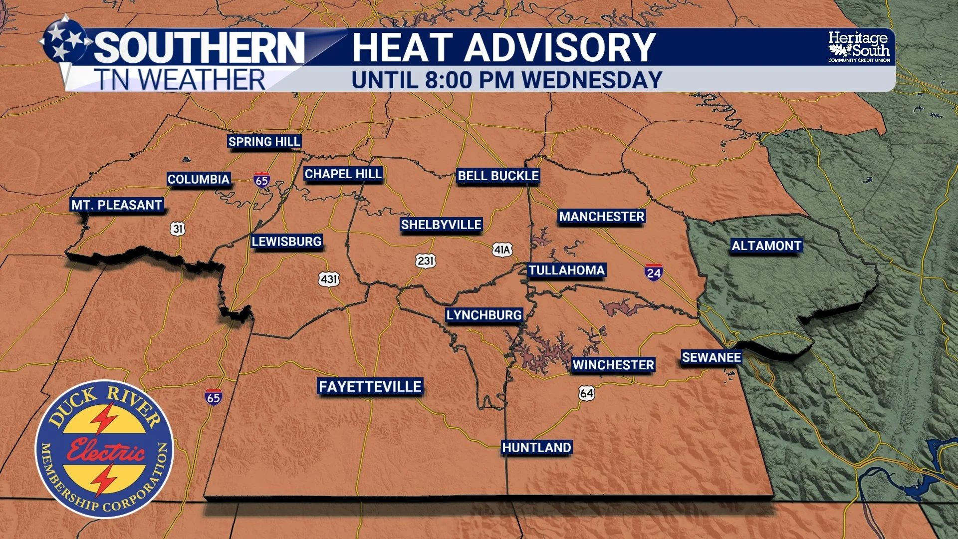
HEAT ADVISORY
How Long Does This Heat Stick Around?
Unfortunately, we're not getting much relief immediately. Wednesday will bring another round of temperatures in the middle and upper 90s, with some locations once again flirting with daily records and triple-digit Heat Index values. The strong ridge overhead will also suppress most cloud and thunderstorm development, meaning rain chances are essentially nonexistent for most of Southern Middle Tennessee.
Thursday and Friday remain very hot as well. Afternoon highs should remain well into the 90s, potentially running around 10 degrees above normal in some locations. Even if Heat Index values fall just short of official advisory criteria in some areas, several consecutive days of excessive heat can take a toll, so heat precautions remain important. Changes should finally begin this weekend as the ridge gradually weakens and shifts away. Temperatures will start trending downward, although Saturday could still be plenty hot. The more noticeable change may arrive Sunday into early next week. Forecast guidance continues to indicate a transition toward cooler temperatures, with highs potentially dropping back into the upper 80s by Monday. Rain chances should also begin increasing, particularly early next week, although there are still some differences in exactly how the developing pattern evolves.
So yes, there is finally some relief showing up on the horizon. We just have several more very hot days to get through first.
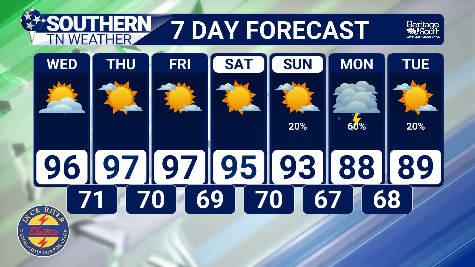
STNWX 7-DAY FORECAST
The Bottom Line 🧾
💧 Relative humidity doesn't simply tell us how much moisture is in the air.
🌡️ It tells us how close the air is to saturation relative to its current temperature.
🌅 Relative humidity is usually highest around sunrise and lowest during the afternoon largely because temperatures are changing.
💦 The amount of atmospheric moisture can remain fairly similar even while relative humidity changes dramatically.
🌡️ Dew point is generally the better measurement for describing how muggy the air feels.
🥵 Dew points around 70° or higher indicate a very humid air mass, even if the afternoon relative humidity doesn't look particularly impressive.
🌫️ Relative humidity remains extremely useful for forecasting fog, clouds, fire weather and many other atmospheric processes.
🔥 Temperatures remain in the middle and upper 90s through the end of the week, with triple-digit Heat Index values possible.
☀️ Rain chances remain extremely low for most of Southern Middle Tennessee through the end of the week.
📉 A gradual cooldown should begin this weekend, with better rain chances and potentially highs back in the 80s early next week.
📰 Reminder: The Southern Tennessee Weather Blog, presented by Heritage South Community Credit Union, is updated Monday through Friday with fresh, locally tailored forecasts you can trust.
