
Weekend Outlook: Stormy Start, Hot & Dry Finish

The Southern Tennessee Weather Blog is proudly presented by Heritage South Community Credit Union.
We Help When Others Won’t!
Visit https://www.heritagesouth.org/ today to see how HSCCU can help YOU!
We've finally made it to Friday, and if you've got outdoor plans this weekend, Saturday is definitely the day you'll want to keep a closer eye on the radar. A very humid atmosphere combined with a weak frontal boundary and a couple of disturbances moving through the region will give us our best opportunity for meaningful rainfall in quite some time today and Saturday. That's certainly welcome news considering the expanding dry conditions we talked about in yesterday's Drought Monitor update. Unfortunately, Mother Nature may once again deliver some of that rain a little too efficiently.
The weekend won't be a complete washout, though. In fact, Sunday looks considerably drier, and once this front moves through, our opportunities for meaningful rainfall may become pretty limited again for much of next week.
Storms Increase Through Friday Evening
We'll start Friday with a mix of sun and clouds and another hot, humid afternoon. High temperatures should climb into the lower to middle 90s for most of us, although locations that see clouds or thunderstorms develop earlier could stay a little cooler. Isolated to scattered showers and thunderstorms will begin popping up as we move through the afternoon, with coverage generally increasing into the late afternoon and evening. A weak frontal boundary stretched across Middle Tennessee will provide one focus for development, while an approaching disturbance will help increase storm coverage across the Tennessee Valley.
There is an incredible amount of moisture available in the atmosphere today. The Nashville National Weather Service measured precipitable water, or PWAT, at 1.96 inches Friday morning, which is above the 90th percentile for this time of year and very close to the daily maximum observed historically. Farther south, atmospheric moisture was even higher, with a Birmingham sounding measuring a PWAT of 2.13 inches, also near record territory for mid-September. PWAT doesn't mean we're all going to receive two inches of rain. Instead, think of it as a measurement of how much water vapor is available throughout the atmosphere. When those values become unusually high, thunderstorms have plenty of moisture available to work with and can become very efficient rainfall producers.
That's our biggest concern today. Storms won't be moving particularly quickly, so the heaviest activity could dump a tremendous amount of rain over a relatively small area in a short period of time. The Weather Prediction Center has placed our area under a Marginal Risk for excessive rainfall, meaning isolated instances of flash flooding will be possible.
A few storms could also become strong, especially this afternoon and early evening. The strongest storms could produce wind gusts around 40–50 MPH, along with frequent lightning and torrential rainfall. There is a low-end potential for a locally damaging wind gust, but the ingredients needed for a more organized or widespread severe-weather event simply aren't impressive. So this isn't a “cancel everything and hide in the basement” kind of setup. But if you've got Friday Night Lights, outdoor events or evening plans, keep an eye on the radar and have somewhere to go if thunder starts rumbling.
And remember: if you can hear thunder, you're close enough to be struck by lightning.
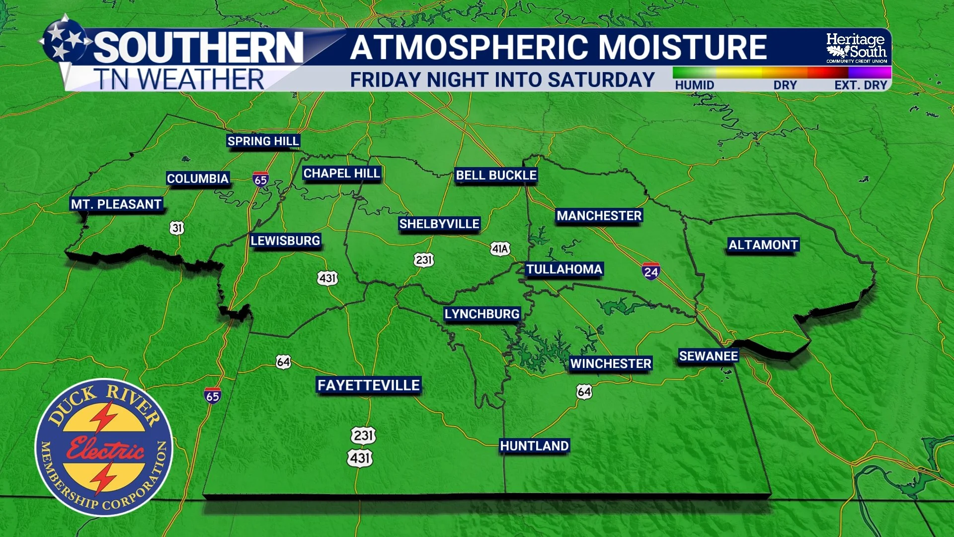
ATMOSPHERIC MOISTURE
Saturday Looks Like the Wettest Day
Saturday is where rain coverage really ramps up. The frontal boundary will slowly settle southward into the area, providing a focus for additional rounds of showers and thunderstorms. Current guidance supports roughly 60–90% rain chances across the Tennessee Valley, with the greatest coverage expected during the afternoon.
That doesn't necessarily mean it rains continuously from sunrise to sunset. There will likely be breaks, and exactly where the front stalls will play a big role in determining which communities see the greatest amount of rainfall. A relatively small northward or southward shift in that boundary could make a noticeable difference in local totals. But if you have outdoor plans Saturday, I'd absolutely plan around the possibility of rain and thunderstorms at some point during the day.
The severe-weather threat actually looks lower Saturday. Instead, our attention turns even more toward heavy rainfall. Atmospheric moisture will remain unusually high, storms will move slowly, and winds through the atmosphere will run roughly parallel to the frontal boundary. That creates the possibility for storms to repeatedly move across some of the same locations. That's something meteorologists call training. Think of individual thunderstorms as train cars following one another along the same track. If several storms repeatedly cross the same community, rainfall totals can add up very quickly.
And considering yesterday's blog about what makes a good soaking rain, there's a bit of irony here. We absolutely need the rain. But getting several inches dumped on one neighborhood in a short period of time isn't nearly as helpful as spreading that rainfall evenly across the region over several hours. Localized flash flooding will therefore remain possible Saturday, especially in poor-drainage areas and anywhere repeated thunderstorms occur.
The additional clouds and rainfall should at least give us a break from the more intense heat. Many locations should hold in the middle 80s to around 90°, although exact temperatures will depend heavily on where and when rain develops.
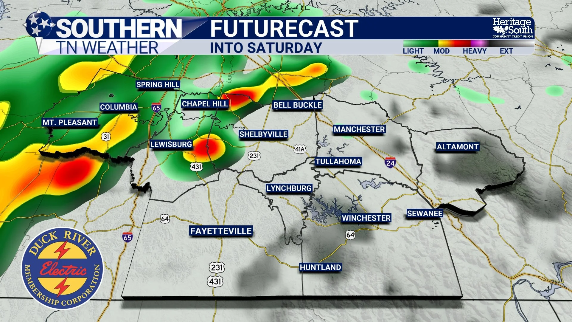
FUTURECAST - INTO SATURDAY
Sunday Dries Out... But Summer Isn't Finished
By Saturday evening, thunderstorms should gradually decrease as the boundary sinks farther south. Much drier weather then takes over Saturday night and Sunday, giving us a substantially better day for outdoor plans to finish the weekend. Unfortunately, don't mistake drier for cooler. The air behind this particular boundary isn't exactly Canadian air rushing south. Humidity will remain noticeable, with dew points hanging around the 70° mark. Sunday afternoon temperatures should range from the upper 80s to lower and middle 90s, and Heat Index values could reach roughly 96–103° in portions of the area.
So if you're waiting for that first crisp fall afternoon where you can throw open the windows and start thinking about chili... This ain't it. 😂
In fact, summerlike weather looks determined to stick around through much of next week. A strong ridge of high pressure is expected to build across the central and eastern United States, sending afternoon temperatures back into the lower and middle 90s. With plenty of humidity remaining in place, Heat Index values could approach or exceed 100° on several afternoons. Rain opportunities also become much less impressive after Saturday. An isolated afternoon shower or thunderstorm can't be completely ruled out on some days next week, especially farther south, but most of us will probably spend much of the week dry.
That's unfortunate considering the expanding Abnormally Dry and Moderate Drought conditions we discussed yesterday. Today and Saturday represent our best opportunity for meaningful rainfall for the foreseeable future, so hopefully we can spread some beneficial totals across a good portion of the area without creating flooding problems.
There may finally be a little light at the end of our seemingly endless summer tunnel, though. We’re beginning to see signals that temperatures could trend closer to seasonal averages by next weekend, and some guidance is even hinting at the possibility of our first legitimate autumn cold front arriving around the time of the fall equinox. That's still more than a week away, so we're definitely not engraving that forecast in stone just yet.
But after this recent stretch of 90s, I'll gladly take a little something to look forward to!
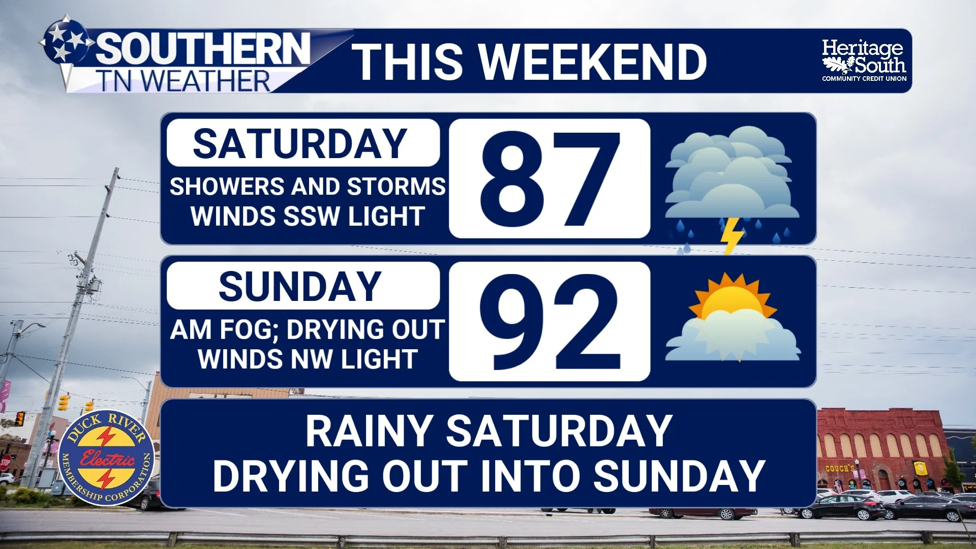
STNWX - THIS WEEKEND
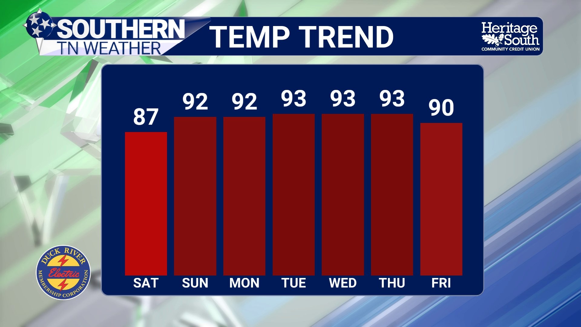
TEMPERATURE TREND
The Bottom Line 🧾
⛈️ Isolated to scattered storms increase this afternoon and evening, with the greatest coverage generally later in the day.
💨 A few stronger storms today could produce 40–50 MPH wind gusts, frequent lightning and torrential rainfall.
💧 Atmospheric moisture is unusually high, so locally intense rainfall rates and isolated flash flooding are possible.
🌧️ Saturday looks like the wettest day of the weekend, with roughly 60–90% rain chances across the area.
⚠️ Saturday's primary concern is locally heavy rainfall, especially if storms repeatedly move across the same locations.
🌤️ Sunday looks considerably drier, but it will remain hot and humid.
🌡️ Sunday Heat Index values could reach roughly 96–103° in portions of the area.
🔥 Lower to middle 90s remain likely through much of next week, with Heat Index values occasionally reaching the lower 100s.
☀️ After Saturday, meaningful rain opportunities become much more limited again.
🍂 There are some early signs of cooler, more seasonable weather by next weekend, possibly associated with our first legitimate autumn cold front. It's still too early to lock that in.
📰 Reminder: The Southern Tennessee Weather Blog, presented by Heritage South Community Credit Union, is updated Monday through Friday with fresh, locally tailored forecasts you can trust.
