
Why Do Weather Alerts Sometimes Seem To "Stop" At The County Line?

The Southern Tennessee Weather Blog is proudly presented by Heritage South Community Credit Union.
We Help When Others Won’t!
Visit https://www.heritagesouth.org/ today to see how HSCCU can help YOU!
If you've lived in Southern Middle Tennessee for very long, you've probably noticed something that can seem a little odd during active weather. A Severe Thunderstorm Warning may include Bedford County, but stop right at the Lincoln County line. A Heat Advisory may cover Coffee County but not Franklin County. Sometimes a Flood Watch appears to end almost perfectly along a county boundary, even though the rain clearly doesn't know where one county ends and another begins.
It's a question I get fairly often, especially during severe weather. "Why does it look like the warning just stops there?" “Why is my town always on the edge?” The short answer is that the weather doesn't stop at the county line—but the responsibility for issuing weather alerts does.
It All Comes Down To Who Covers Your County
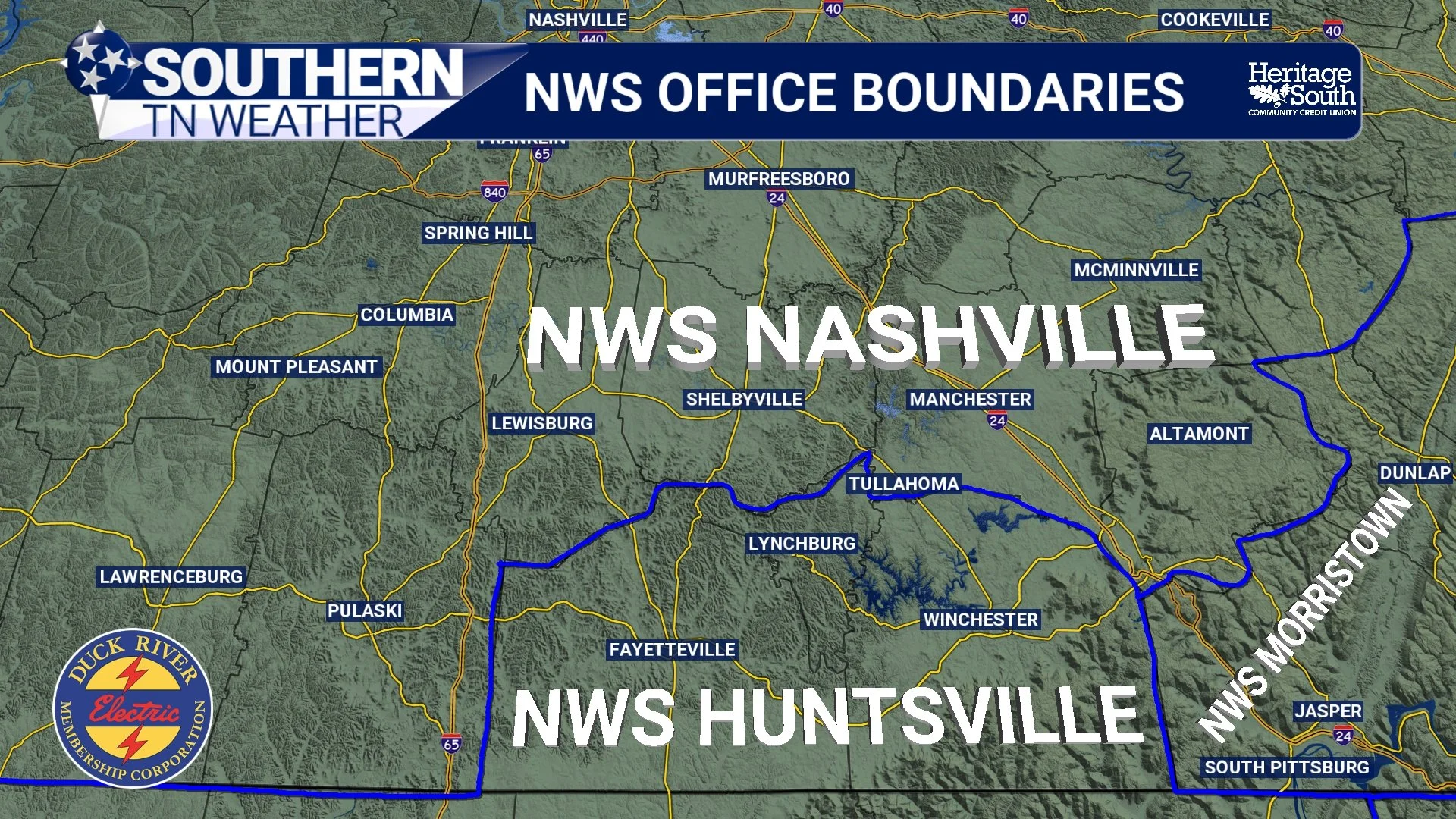
One thing many people don't realize is that Southern Middle Tennessee actually sits along the boundary of two different National Weather Service forecast offices. The National Weather Service office in Nashville is responsible for Bedford, Coffee, Grundy, Marshall, and Maury counties. Meanwhile, Franklin, Lincoln, and Moore counties fall under the National Weather Service office in Huntsville.
Both offices are looking at the exact same atmosphere, but each one is responsible for forecasting and issuing weather products for its own group of counties. That includes everything from daily forecasts to Severe Thunderstorm Warnings, Tornado Warnings, Flood Watches, Heat Advisories, Dense Fog Advisories, and dozens of other products. Most of the time, you'll never notice that invisible boundary. During quiet weather, forecasts from both offices are usually very similar because they're dealing with the same weather system. It's during more localized weather events that the differences can become more noticeable.
Weather Doesn't Care About County Lines
The atmosphere, of course, couldn't care less where Bedford County ends and Lincoln County begins. A thunderstorm doesn't suddenly weaken because it crosses into another county. Heavy rain doesn't stop falling simply because it reaches the edge of a forecast area. The same is true for dangerous heat, dense fog, freezing rain, or just about any other type of weather.
Nature operates continuously. Forecast responsibility does not. That's why alerts can sometimes appear to end right along a county line. You're not seeing the weather stop—you're seeing where one forecast office's responsibility ends and another office's begins.
Why Neighboring Counties Don't Always Receive The Same Alerts
This is where forecasting becomes both challenging and fascinating. Every watch, warning, or advisory is based on a meteorologist's assessment of where hazardous weather is expected to occur. Sometimes those decisions are easy. Other times they're much more difficult, especially during the summer when thunderstorms can develop over one community while another just a few miles away stays completely dry.
Even though Nashville and Huntsville coordinate closely throughout the day, each office ultimately makes decisions for the counties they're responsible for. One office may determine that confidence is high enough to issue a Heat Advisory or Flood Watch, while the neighboring office may decide conditions fall just short of their criteria.
That doesn't mean one office is right and the other is wrong. It simply reflects the uncertainty that exists in weather forecasting, especially when hazards are expected to develop near the boundary separating the two forecast areas.
Warnings Work A Little Differently
Warnings add another layer of complexity because they're issued for weather that's happening right now, not weather that's expected later in the day. Imagine a severe thunderstorm moving east across Bedford County. Since Bedford is forecast by Nashville, the National Weather Service office there issues the warning. If that same storm continues into Lincoln County, responsibility transitions to Huntsville. From your perspective, it may look like one warning suddenly ends and another begins.
Behind the scenes, though, the two offices are communicating continuously. Meteorologists coordinate storm tracks, warning polygons, and expected impacts so the transition between forecast areas is as seamless as possible. Even though different offices are issuing the warnings, they're working together to make sure communities continue receiving timely information as storms move across the region.
Why Southern Tennessee Weather Covers Both
This is one of the reasons Southern Tennessee Weather follows both forecast offices every single day. Our coverage area doesn't neatly fit inside one National Weather Service office. We serve communities that fall under both Nashville and Huntsville, and many of you travel between those counties every day for work, school, or family.
Rather than forcing you to keep up with multiple forecast offices, we monitor information from both, compare their forecasts, and communicate what it all means for Southern Middle Tennessee as a whole. If there are differences between the two offices, we'll explain why they exist instead of simply repeating headlines. Our goal has always been to provide one clear, consistent forecast for the entire region—even when the weather doesn't fit neatly inside a forecast boundary.
The Bottom Line 🧾
Southern Middle Tennessee is served by two National Weather Service forecast offices.
NWS Nashville covers Bedford, Coffee, Grundy, Marshall, and Maury counties, while NWS Huntsville covers Franklin, Lincoln, and Moore counties.
Weather doesn't stop at county lines, but forecast office responsibilities do.
That's why watches, warnings, and advisories can sometimes appear to "cut off" at county boundaries.
The two forecast offices coordinate closely, but each makes decisions for the counties it serves.
Southern Tennessee Weather monitors both offices to provide one complete forecast for all eight counties in our coverage area.
📰 Reminder: The Southern Tennessee Weather Blog, presented by Heritage South Community Credit Union, is updated Monday through Friday with fresh, locally tailored forecasts you can trust.