
Complicated Forecast for Saturday: Latest Details Here

The Southern Tennessee Weather Blog is proudly presented by Heritage South Community Credit Union.
We Help When Others Won’t!
Visit https://www.heritagesouth.org/ today to see how HSCCU can help YOU!
If you've been following my forecasts over the past couple of days, you've probably noticed that I've been using the word "complicated" quite a bit when talking about Saturday's weather.
There's a good reason for that.
Confidence is high that showers and thunderstorms will develop somewhere across Middle Tennessee this weekend. The challenge isn't determining if storms will form—it's figuring out where they'll form. And in a summertime weather pattern like this, a shift of only 25 to 50 miles can completely change who sees heavy rain, who experiences stronger storms, and who stays mostly dry.
A Few Storms Remain Possible Today
Before we get to Saturday, we'll continue watching for a few scattered showers and thunderstorms through early this evening. Earlier this morning, a weakening mesoscale convective system (MCS) crossed the Tennessee River and gradually fell apart as it entered Middle Tennessee. That activity has left today's forecast with a bit of uncertainty, as breaks in the clouds could still allow the atmosphere to recover enough for a few additional storms this afternoon.
If one develops, damaging wind gusts and heavy rainfall would be the primary concerns. Overall, however, the severe weather threat remains fairly low.
Why Saturday's Forecast Is So Difficult
Saturday's weather depends on several small-scale features that forecast models often struggle to handle accurately.
The first is another MCS expected to develop to our west tonight before moving toward Tennessee early Saturday morning. Based on current trends, I expect it to weaken as it approaches our area, much like Friday morning's complex. But here's where things become tricky. Even after thunderstorms weaken, they don't simply disappear. They leave behind outflow boundaries—essentially miniature cold fronts created by cool air spreading outward from collapsing thunderstorms. Those boundaries frequently become the focus for a new round of thunderstorm development later in the day.
The problem is that forecast models have been all over the place with where those boundaries end up. Some solutions keep the morning activity mainly north of our area, delaying afternoon redevelopment. Others bring the morning storms farther south, placing those boundaries directly across Southern Middle Tennessee and allowing thunderstorms to become much more widespread by late morning or early afternoon. A few model runs even keep the greatest storm coverage closer to Kentucky for much of the day. Take a look at the two photos below. I’m showing both the morning and afternoon runs of today’s HRRR. Look at how different their storm placement is. This is the kind of variability we’re dealing with.
When the placement of one of these boundaries changes by only a county or two, the entire forecast changes with it. One community could receive several inches of rain while another just a few miles away stays mostly dry. That's why I've been emphasizing uncertainty. I'm confident that someone will experience heavy rain and numerous thunderstorms Saturday. I'm simply not confident enough yet to tell you exactly where that corridor will set up.
This is one of those forecasts where radar trends Saturday morning will become just as important as the forecast models. Once we see where the overnight storms track and where those leftover boundaries settle, confidence in the afternoon forecast should increase considerably.
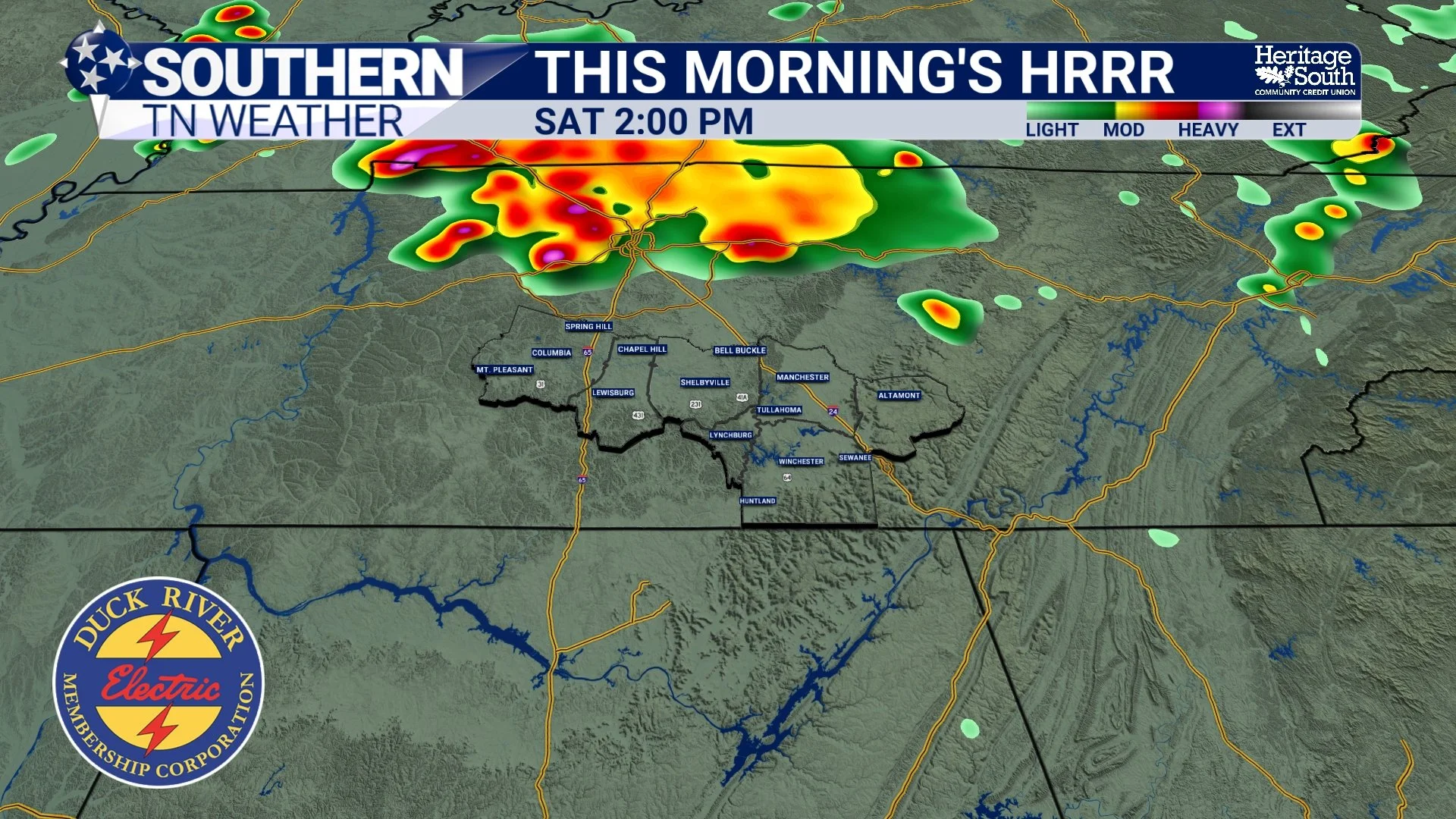
THIS MORNING’S HRRR
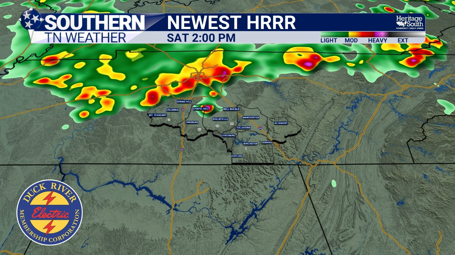
NEWEST HRRR
Flooding Is The Bigger Concern
While a few stronger storms capable of producing damaging wind gusts remain possible Saturday, I'm actually more concerned about the heavy rainfall potential. The atmosphere will contain an exceptional amount of moisture for late June, with precipitable water values approaching 2 inches, which is near the 99th percentile for this time of year. Simply put, there's plenty of moisture available for storms to work with.
Because winds higher in the atmosphere remain fairly weak, thunderstorms won't move very quickly. Instead, several storms could repeatedly move over the same locations—a process meteorologists call training. Think of train cars traveling along the same track. Rather than one storm moving through, multiple storms pass over the same area one after another, allowing rainfall totals to pile up in a short amount of time.
That's why the National Weather Service has issued a Flood Watch for portions of northern Middle Tennessee (not our area), where confidence is currently highest that heavier rainfall may occur. At the moment, I think the greatest flooding threat remains north of much of our coverage area, but if those storm boundaries shift farther south, so will the axis of heavier rainfall. Take a look at the latest rainfall forecast from the HRRR below. It shows some mighty high totals for parts of Middle TN through Saturday night.
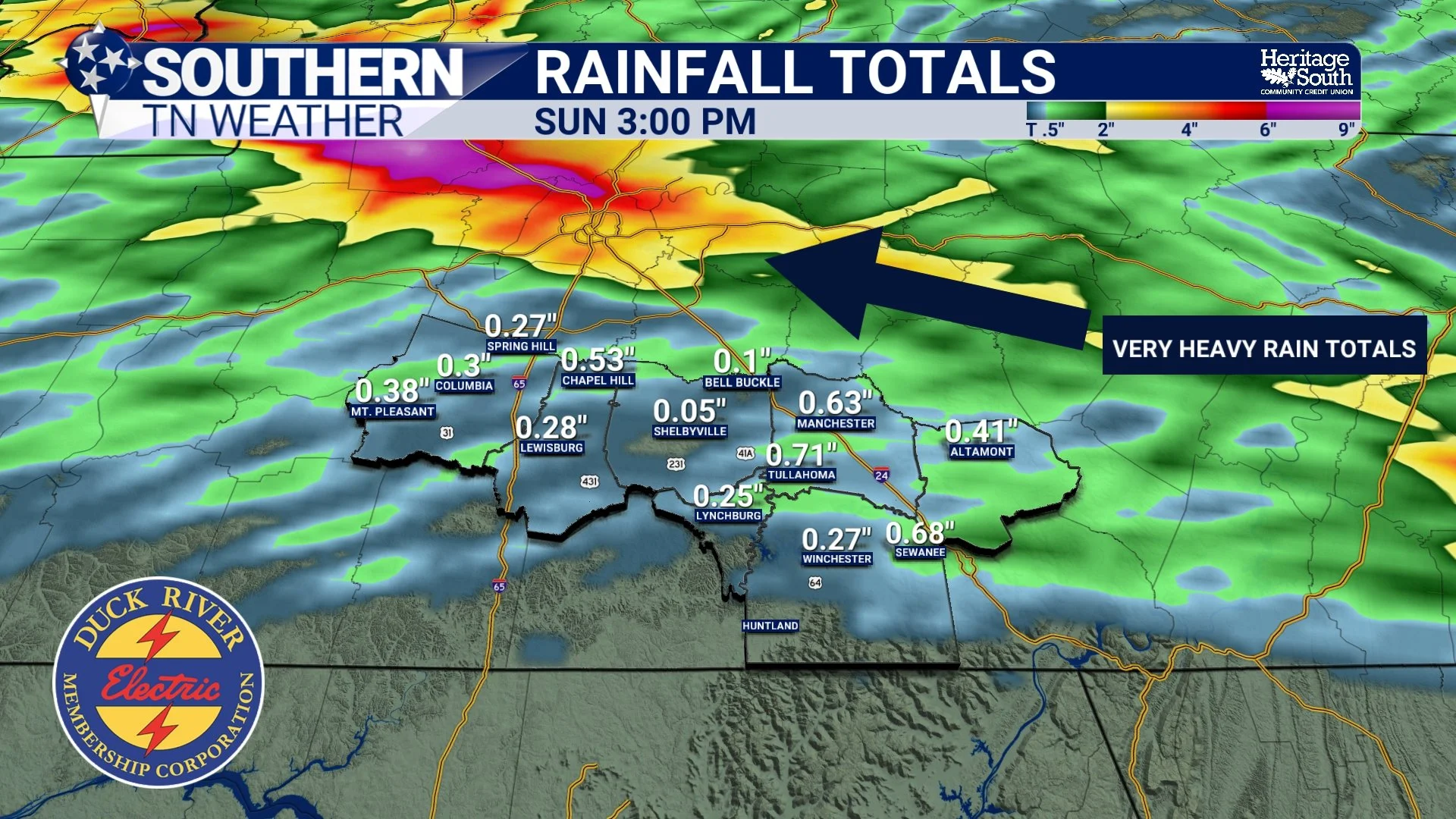
RAINFALL TOTALS - THRU SUNDAY
What About Severe Weather?
The severe weather threat remains on the lower end. Wind shear is fairly weak, which makes it difficult for thunderstorms to organize into long-lived severe storms. Even so, the atmosphere will become moderately unstable on Saturday afternoon.
That means a few storms could briefly become strong enough to produce damaging wind gusts up to 60 MPH. The tornado threat across Southern Middle Tennessee remains very low, but as we saw on Monday in Franklin County, we can NEVER say it’s zero. A MARGINAL risk (level 1/5) remains in place from the Storm Prediction Center.
Then Comes The Heat
Once we get beyond this weekend, the weather story changes dramatically. A strong ridge of high pressure will build across the Southeast beginning Sunday and strengthen through much of next week. Rain chances will gradually decrease while temperatures climb into the middle and upper 90s each afternoon.
When combined with dew points in the middle 70s, heat index values between 100° and 105° will become common. The National Weather Service continues forecasting Major to Extreme HeatRisk through much of next week, meaning prolonged outdoor exposure will become increasingly dangerous, especially with overnight lows only falling into the middle and upper 70s.
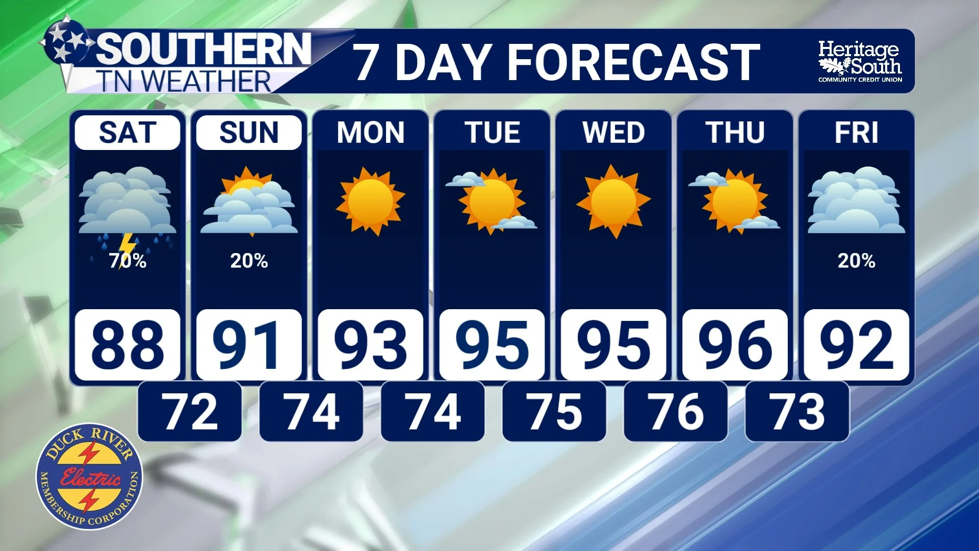
STNWX 7-DAY FORECAST
Looking Ahead
Saturday is one of those forecasts where placement is everything. The ingredients for heavy rain and thunderstorms will be in place, but the exact location of overnight storm complexes and the boundaries they leave behind will determine who sees the greatest impacts.
I'll be watching radar trends closely tonight and Saturday morning and will provide updates as confidence increases.
The Bottom Line 🧾
A few showers and thunderstorms remain possible through this evening.
Saturday brings the highest rain chances of the weekend.
The exact placement of storms will determine where the heaviest rain falls.
Heavy rainfall and localized flooding are the primary concerns.
A Flood Watch is in effect for portions of northern Middle Tennessee (not our area).
A few storms could produce damaging wind gusts, but the tornado threat remains very low.
Dangerous heat builds Monday through much of next week, with heat index values above 100° likely each afternoon.
📰 Reminder: The Southern Tennessee Weather Blog, presented by Heritage South Community Credit Union, is updated Monday through Friday with fresh, locally tailored forecasts you can trust.