
First Look Forecast for Independence Day

The Southern Tennessee Weather Blog is proudly presented by Heritage South Community Credit Union.
We Help When Others Won’t!
Visit https://www.heritagesouth.org/ today to see how HSCCU can help YOU!
With Independence Day just a few days away, I've been getting one question more than any other: "What's the weather going to be like on the Fourth?"
The good news is that we're finally getting close enough for forecast confidence to improve. While there are still a few details to fine-tune, the overall weather pattern is becoming much clearer. Before we get there, though, we have to get through one of the hottest stretches of weather we've seen in over a year.
Dangerous Heat Continues Through Friday
The weather story for the remainder of the work week remains the dangerous heat. An EXTREME HEAT WARNING continues across much of Southern Middle Tennessee, with afternoon temperatures climbing into the middle and upper 90s. Combine that with dewpoints well into the 70s, and it will feel more like 105° to 110° during the hottest part of the day. Perhaps the most frustrating part of this heat wave is the lack of overnight relief. Instead of cooling into the 60s, overnight lows will only fall into the middle and upper 70s, with a few locations struggling to drop below 80°. That means homes, roads, and buildings have very little opportunity to cool off before the next day's heat begins.
If you have to spend time outdoors over the next few days, continue taking the heat seriously. Drink plenty of water, take frequent breaks in the shade or air conditioning, and never leave children or pets inside a parked vehicle.
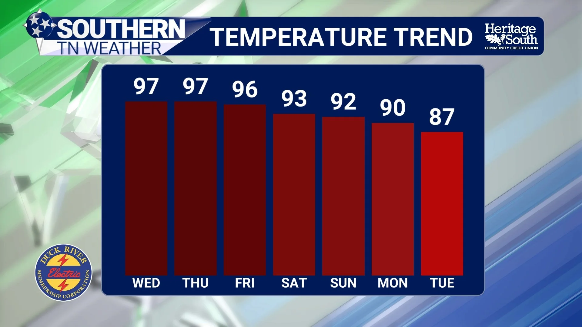
TEMP TREND - NEXT 7 DAYS
Rain Chances Slowly Return
The stubborn ridge of high pressure that's been baking the Southeast will begin weakening ever so slightly during the second half of the week. It won't be enough to end the heat, but it will allow a few weak disturbances to rotate around the edge of the ridge and into Middle Tennessee. Beginning Wednesday afternoon, isolated showers and thunderstorms will once again become possible. Coverage should remain fairly limited, with many communities staying completely dry. By Thursday and Friday, rain chances increase a bit more as those disturbances become more numerous.
The Storm Prediction Center has placed portions of our area under a MARGINAL RISK (Level 1 of 5) for severe thunderstorms on Thursday. The overall severe weather threat remains fairly low, but a few stronger storms could produce damaging wind gusts, especially during the afternoon and evening hours.
Wind shear remains relatively weak, which should limit the potential for widespread organized severe weather. However, the atmosphere will be loaded with instability thanks to the intense heat and humidity. That means any thunderstorm that develops will have plenty of energy to work with, allowing a few storms to briefly become strong before collapsing. In addition to gusty winds, expect torrential rainfall, frequent lightning, and perhaps some small hail with the strongest storms.
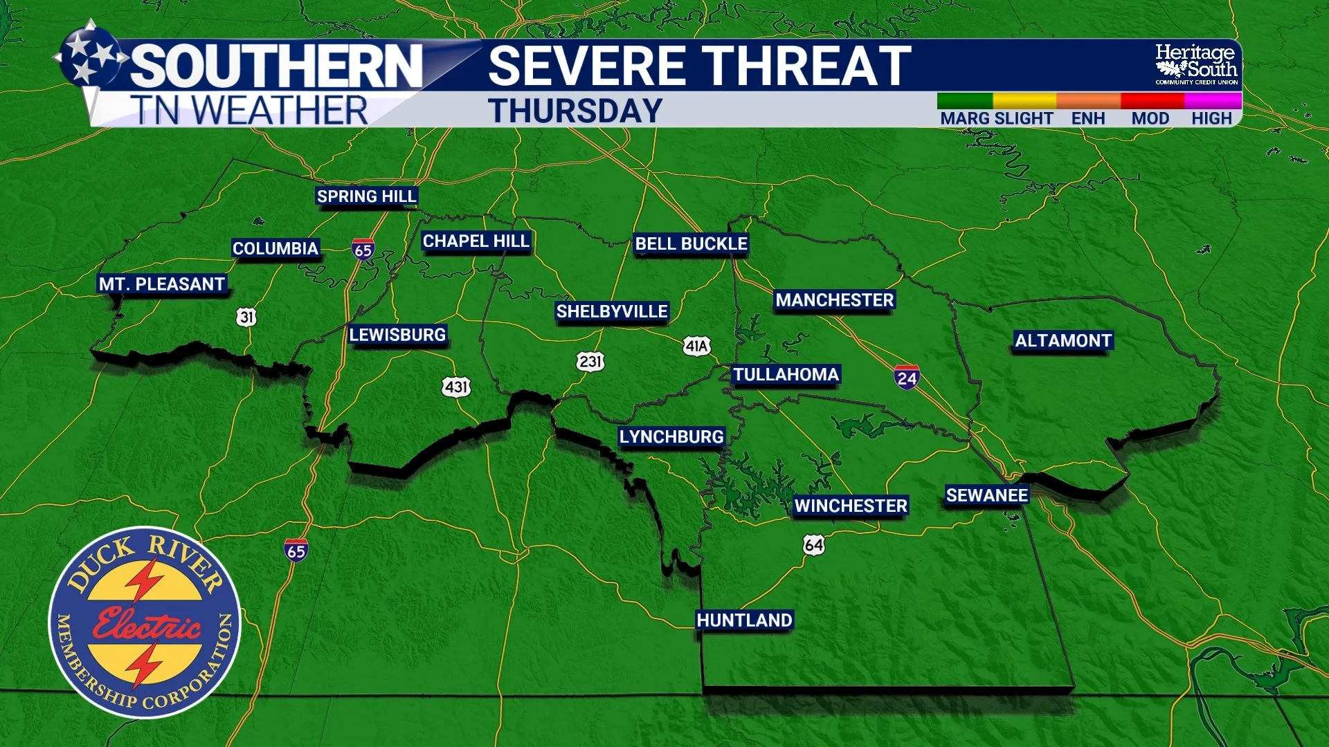
SEVERE THREAT - THURSDAY
So... What About Independence Day?
Right now, Independence Day is actually shaping up fairly well. Current forecast guidance suggests we'll continue carrying isolated to scattered afternoon and evening thunderstorm chances, but there is no indication of an all-day rain event or widespread severe weather at this time. In other words, this looks like a fairly typical July weather pattern.
Most communities should spend much of the day dry, hot, and humid. During the afternoon, daytime heating could spark a few pop-up thunderstorms. Like most summertime storms, they'll be hit-or-miss. Some neighborhoods may see a quick downpour while others just a few miles away never receive a drop of rain. If you have outdoor cookouts, parades, ballgames, or fireworks planned, I certainly wouldn't cancel them. Instead, I'd simply keep an eye on the radar and have a backup plan in case one of those isolated storms drifts overhead. Hopefully, any storms that do develop will diminish after sunset, allowing many communities to enjoy fireworks without much interruption.
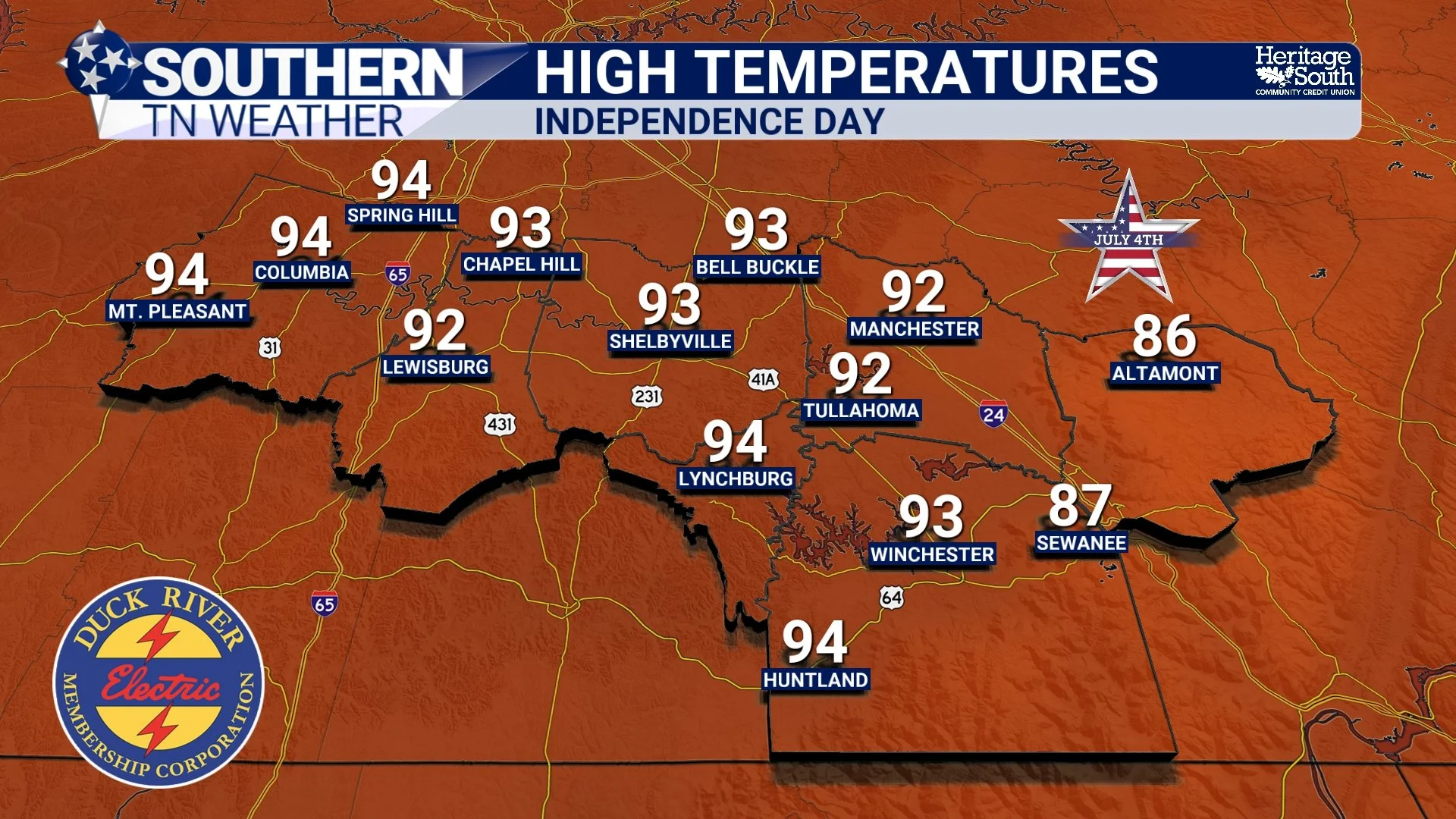
HIGH TEMPS - INDEPENDENCE DAY
Looking Beyond The Holiday
Rain chances remain in the forecast through the holiday weekend before increasing somewhat later in the weekend and into early next week as the ridge weakens further and a trough digs into the Great Lakes. Ironically, that's actually good news.
More clouds and scattered thunderstorms should help knock temperatures back a few degrees, bringing us closer to what's considered normal for early July. It'll still be warm and humid, but hopefully not quite as oppressive as what we're experiencing now. Of course, I'll continue refining the Independence Day forecast over the next couple of days as newer data becomes available.
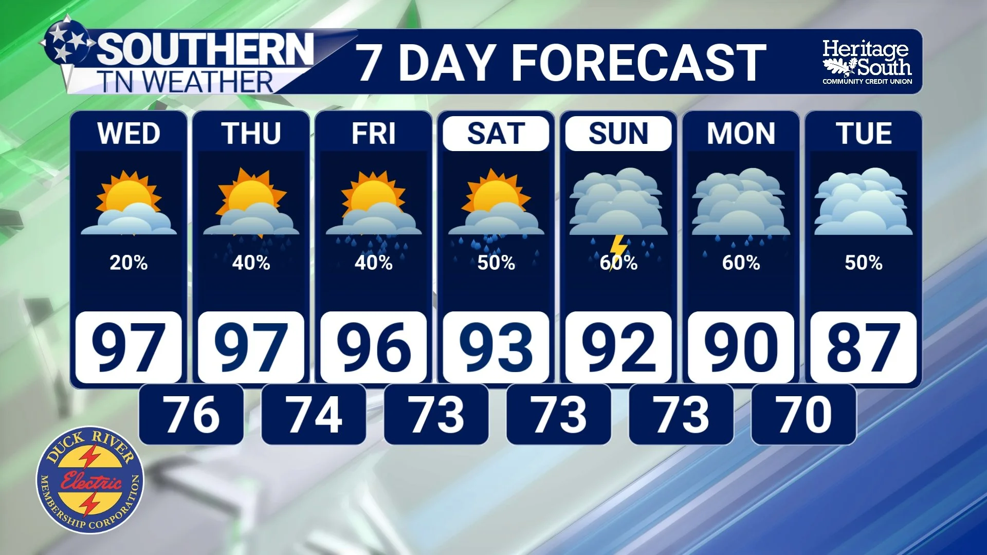
STNWX 7-DAY FORECAST
The Bottom Line 🧾
Dangerous heat continues through at least Friday with heat index values between 105° and 110°.
Overnight temperatures will remain unusually warm, offering very little relief.
Isolated thunderstorms return Wednesday, with better coverage expected Thursday and Friday.
A MARGINAL RISK (Level 1 of 5) for severe thunderstorms is in place Thursday. Damaging wind gusts are the primary concern.
Independence Day currently looks favorable for most outdoor plans, although a few pop-up afternoon and evening thunderstorms remain possible.
Rain chances increase later in the holiday weekend before temperatures begin easing closer to seasonal normals early next week.
📰 Reminder: The Southern Tennessee Weather Blog, presented by Heritage South Community Credit Union, is updated Monday through Friday with fresh, locally tailored forecasts you can trust.