
Why Can't We Trust Exact Rainfall Totals Several Days Away?

The Southern Tennessee Weather Blog is proudly presented by Heritage South Community Credit Union.
We Help When Others Won’t!
Visit https://www.heritagesouth.org/ today to see how HSCCU can help YOU!
If you've looked at some of the rainfall forecast maps floating around over the past couple of days, you've probably noticed something we haven't seen around here in quite a while: A LOT of rain. Some guidance has been painting several inches of rainfall across portions of Southern Middle Tennessee this weekend into early next week. Considering how quickly our drought has worsened, with Extreme Drought now affecting part of Bedford County, those maps are certainly enough to get your attention. But here's where I have to be the boring meteorologist and pump the brakes just a little bit.
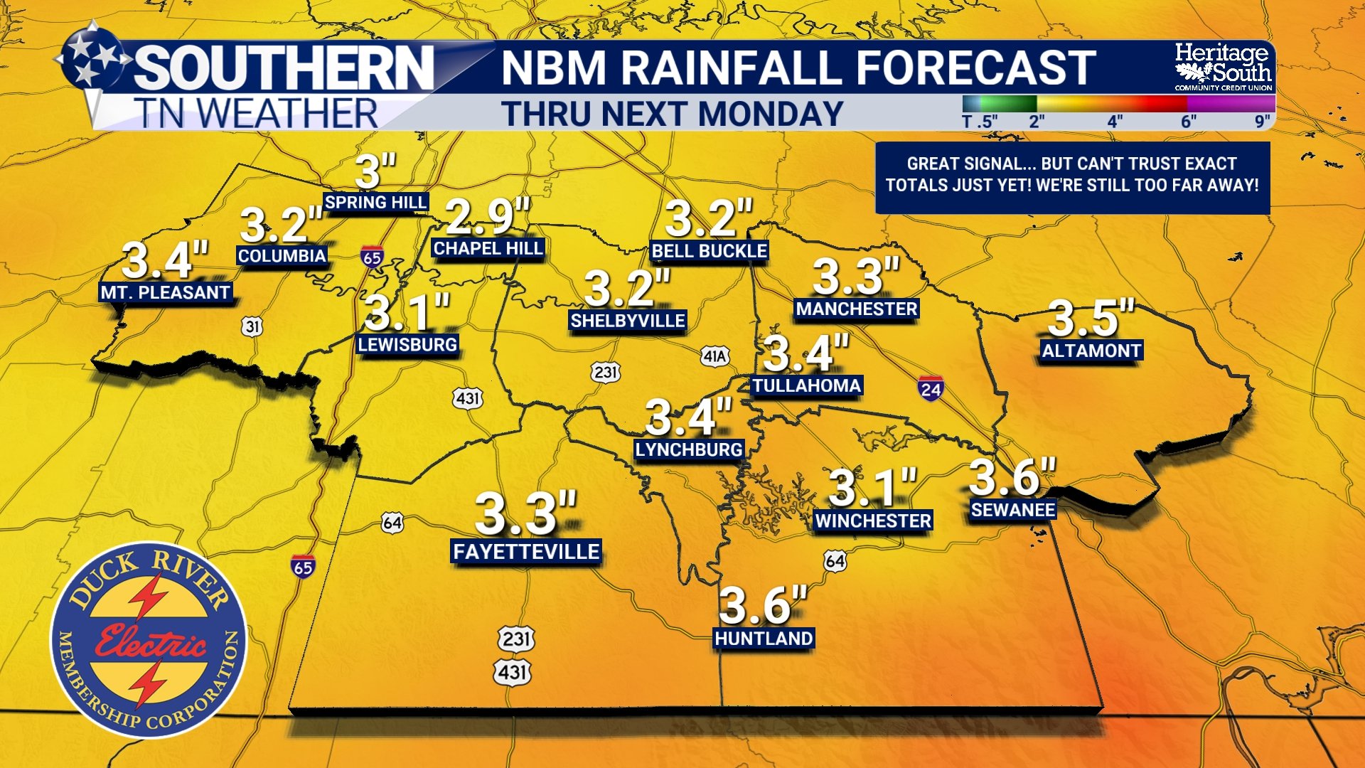
If a computer model paints exactly 3.27 inches over Shelbyville several days from now, that does NOT mean I'm forecasting 3.27 inches of rain in Shelbyville. In fact, the decimal point may be one of the least useful pieces of information on the entire map this far in advance. That doesn't mean the forecast is useless. Far from it. There is now a legitimate and increasingly encouraging signal for a widespread soaking rainfall across our area this weekend. The important thing is understanding the difference between having confidence that a rainy pattern is coming and having confidence in exactly how much rain will fall in your backyard.
A Rainfall Forecast Has A LOT of Moving Parts
Think about trying to predict where a car traveling across the country will eventually stop. Several days beforehand, you might have enough information to confidently say it's headed toward Tennessee. Predicting exactly which exit it'll take, precisely what time it'll arrive and which parking spot it'll eventually pull into is much more difficult. Rainfall forecasting works in a similar way. The atmosphere is constantly evolving, and the farther into the future we look, the more opportunity there is for small differences in the forecast to grow. A low-pressure system tracking slightly farther north or south, moving six hours faster or slower, or becoming a little stronger or weaker can substantially change where the heaviest rain ultimately falls.
Then we have to determine how much moisture will actually be available when the system arrives. How strong will the southerly flow become? How much moisture gets transported northward? Where will the strongest lift develop? How quickly will everything move? Will several disturbances interact with one another? Will bands of heavier rain repeatedly move over the same locations? Change any of those ingredients, and the rainfall map can change substantially.
That's particularly important with the system we're watching this weekend because this isn't necessarily one simple storm moving from Point A to Point B. Current forecast guidance suggests several pieces of the atmosphere could come together, including moisture arriving from the Gulf, another disturbance and front approaching from the north, and a larger low-pressure system moving in from the west with additional Pacific tropical moisture. Exactly how those features interact will help determine when the heaviest rain develops, how long it lasts and, ultimately, how much falls. That's why a rainfall forecast several days away can change considerably even when the overall idea that “it's probably going to rain” remains intact.
TITLE PAGE
One Model Run Is NOT a Forecast
This is probably the most important thing to remember whenever you see one of those colorful computer-model rainfall maps plastered all over social media: a single model run is only one possible solution. Computer models begin with their best estimate of what the atmosphere looks like right now and then use mathematical equations to simulate how it could evolve. But our observations of the atmosphere aren't perfect, and neither are the models themselves. Tiny differences in those starting conditions can grow with time, eventually producing noticeably different outcomes several days down the road.
That's one reason meteorologists rely so heavily on ensembles. Instead of running a model only once, an ensemble produces many simulations with small variations in the starting conditions and, depending on the system, aspects of the model itself. That allows us to look at a collection of possible outcomes rather than putting all our faith into one computer simulation. Imagine 50 people starting down the same hiking trail. They're all trying to reach roughly the same destination, but they begin a few feet apart and make slightly different decisions along the way. After a short distance, they're probably still fairly close together. Several miles later, those tiny differences can put them in noticeably different places. The atmosphere behaves similarly. The farther into the future we go, the more those small differences can matter.
So instead of asking, “How much rain does this one model show over my house?” I'm much more interested in whether multiple models are showing a wetter pattern, whether their ensembles are consistently wet, whether the large-scale atmospheric setup actually supports widespread rainfall, and whether that signal persists from one forecast cycle to the next. When all of those pieces start lining up, our confidence in the overall idea of meaningful rainfall can increase even while the exact totals remain uncertain.
The Signal Matters More Than the Number
That brings us directly to this weekend, because we're beginning to see a pretty impressive moisture signal in the forecast. According to the National Weather Service in Nashville, atmospheric moisture values that begin this week around the 10th percentile could climb to around the 95th percentile by Saturday. In plain English, we're going from an unusually dry atmosphere to one containing considerably more moisture than we would typically expect this time of year. More importantly, this isn't simply one computer model throwing out a ridiculous rainfall total. Multiple major ensemble systems are pointing toward a soaking rainfall. Current ensemble guidance indicates a high chance of receiving more than 1 inch of rain this weekend, around a 40% chance of exceeding 2 inches, and roughly a 20% chance of exceeding 3 inches. The heaviest rainfall currently appears most likely from Saturday afternoon through Sunday morning.
Notice the difference between those probabilities and simply saying, “We're getting three inches this weekend.” More than an inch is becoming increasingly likely across the Nashville forecast area. Two inches is certainly possible, and three inches or more remains possible, but confidence naturally decreases as we move toward those higher totals. Those probabilities will also continue changing as we get closer and the details of the system become clearer. This is also where products such as the National Blend of Models, or NBM, can be useful. Instead of relying on one forecast model, the NBM combines information from numerous sources into a blended forecast, helping reduce our dependence on the quirks of any individual model. But blending guidance doesn't magically eliminate uncertainty. In fact, blending can sometimes smooth out important differences. Imagine one model placing the heaviest rain over Bedford County, another placing it over Franklin County and another shifting it farther west. Blend all of those together and you may end up with a broad area of moderate rainfall, even though none of those individual solutions actually produced that exact rainfall pattern.
So even when an NBM map looks beautifully smooth and specific, it still shouldn't be interpreted as a promise that every town will receive exactly the number printed over it. And then there's one more complication: thunderstorms and heavy rain bands don't distribute rainfall evenly. Anyone who has lived through a Southern Middle Tennessee summer already knows how ridiculous those differences can become. One town can get absolutely hammered while another location ten miles away barely gets enough rain to wet the driveway. The current weekend setup appears more supportive of widespread showery rainfall with relatively limited thunderstorm activity, which could help make rainfall more widespread than a typical summertime scattered-thunderstorm setup. However, heavier downpours and some thunderstorms will still be possible. If bands of heavy rain repeatedly move across the same locations, a process often called training, localized totals could end up considerably higher than surrounding areas.
That's also why flooding can't automatically be ruled out simply because we're in a drought. Our dry conditions mean the region should initially be capable of handling quite a bit of rainfall, and a widespread soaking rain would be extremely beneficial, but rainfall rate still matters. Three inches spread over a couple of days is a very different situation from three inches falling over the same location in only a few hours.
NBM RAINFALL FORECAST - THRU NEXT MONDAY
So When CAN We Start Trusting the Numbers?
There's no magical hour when a rainfall forecast suddenly becomes perfect. Instead, confidence gradually improves as the event gets closer. Several days out, I'm primarily interested in the pattern and the signal. Is there a storm system approaching? Is plenty of moisture available? Do multiple models and ensembles support rain? Does the overall atmospheric setup make sense? Most importantly, is that signal persisting from run to run? As we move closer, the expected track, timing and strength of the system become clearer. Higher-resolution models eventually enter their useful forecast window, and meteorologists can begin examining smaller-scale features that could influence where heavier rainfall develops. Even then, exact totals can vary substantially over relatively short distances.
That's why you'll often notice the wording of a forecast evolve as an event approaches. We may begin with “there's a signal for widespread rainfall next weekend,” eventually transition toward a range such as “1–2 inches appears increasingly likely,” and only closer to the event begin discussing where locally higher totals could occur. That isn't the forecast “changing every five minutes.” It's the forecast becoming more specific as uncertainty decreases and better information becomes available. And that's exactly the process we're going through with this weekend.
From the 40s to the 90s... Then a Soaking Rain?
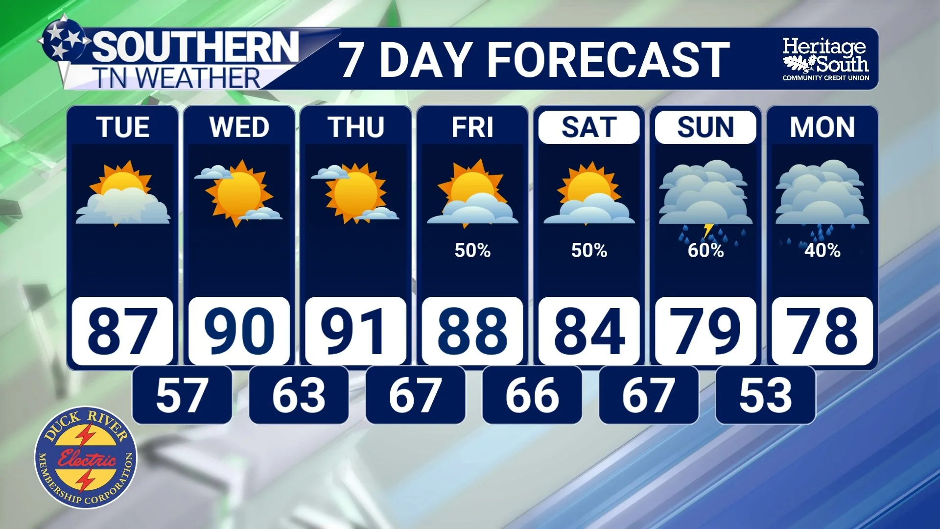
We're starting this week on almost the complete opposite end of the weather spectrum. High pressure, sunshine and exceptionally dry air are dominating Southern Middle Tennessee after temperatures fell into the mid to upper 40s across many locations Monday morning. From here, though, temperatures and humidity are both going UP. Tuesday should warm well into the 80s before highs reach the upper 80s to lower 90s Wednesday and Thursday, roughly 10–15 degrees above normal in portions of the area. Southerly winds will also begin transporting more moisture northward, gradually replacing the exceptionally dry air we're enjoying now with a much more humid air mass.
By Friday, the pattern begins changing more substantially as rain chances start returning. From there, confidence is increasing that rainfall will become much more widespread over the weekend, with Saturday afternoon through Sunday morning currently looking like the period with the greatest potential for heavier rainfall. There are still important details to resolve. Forecast guidance remains divided on exactly how quickly widespread rain develops Friday and Saturday, while uncertainty also remains over how several approaching weather systems will interact. Those details could make a BIG difference in eventual rainfall totals.
But compared with where we were even a few days ago, the overall signal for a soaking rainfall has become considerably more encouraging. Considering our worsening drought, that's about as welcome of a forecast signal as we could ask for!
STNWX 7-DAY FORECAST
The Bottom Line 🧾
🌧️ A rainfall map showing 3 inches several days away does NOT mean your backyard is forecast to receive exactly 3 inches.
🖥️ Individual computer-model runs represent possible outcomes, not guarantees.
📊 Ensembles allow us to examine many possible outcomes and determine how strong the overall forecast signal really is.
🎯 Several days in advance, the overall pattern, model agreement and consistency are usually much more useful than exact rainfall totals.
💧 Atmospheric moisture could increase dramatically by Saturday, rising from unusually dry levels early this week to around the 95th percentile.
🌧️ Ensemble guidance currently shows a high chance of more than 1 inch, around a 40% chance of more than 2 inches, and roughly a 20% chance of more than 3 inches this weekend.
🌡️ Before the rain arrives, temperatures surge into the upper 80s and lower 90s Wednesday and Thursday as humidity gradually increases.
☔ Rain chances begin returning Friday, with the heaviest rainfall currently favored Saturday afternoon through Sunday morning.
🌵 For our drought-stricken region, the growing signal for a widespread soaking rain is VERY encouraging, but it's still too early to lock in exact totals.
📰 Reminder: The Southern Tennessee Weather Blog, presented by Heritage South Community Credit Union, is updated Monday through Friday with fresh, locally tailored forecasts you can trust.
