
Why Are We Staying so Dry? A Look Inside the Forecast

The Southern Tennessee Weather Blog is proudly presented by Heritage South Community Credit Union.
We Help When Others Won’t!
Visit https://www.heritagesouth.org/ today to see how HSCCU can help YOU!
Our stretch of quiet weather continues across Southern Middle Tennessee today, and at first glance the forecast looks pretty simple. Sunshine, comfortable temperatures, and no rain in sight. But if you dig into today’s forecast discussion, there is actually a really interesting story playing out behind the scenes. We have disturbances nearby, clouds at times, and even subtle lift in the atmosphere. Yet we continue to stay dry. So what is going on?
Why We Keep Missing Out on Rain
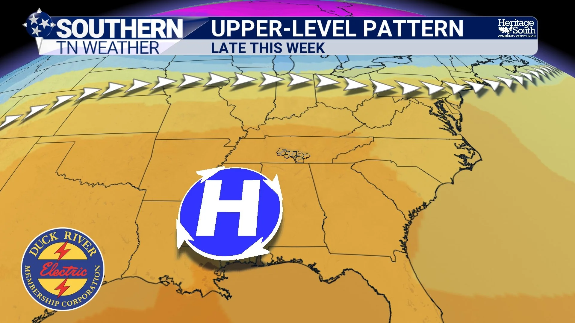
Today’s setup features weak disturbances moving through the broader region. Normally, those would be enough to at least spark a few showers, especially this time of year. The problem is the environment they are moving into. We are currently under the influence of a ridge of high pressure aloft. That ridge promotes sinking air, and sinking air works directly against storm development.
As air sinks, it warms and dries out, which makes it very difficult for clouds to grow vertically and produce precipitation. So even though these weak systems are passing nearby, the atmosphere over Southern Middle Tennessee is essentially shutting them down before they can do anything meaningful. That is why you may notice passing high clouds at times, but nothing more than that…
The Warm-Up Is Already Beginning
At the surface, high pressure is shifting east, and that is beginning to change our wind direction. Winds are gradually turning out of the southeast and will become more southerly heading into Thursday and Friday. That shift is important because it marks the start of return flow. Once winds turn southerly, we begin pulling in a warmer air mass from the south.
At the same time, the ridge overhead is expected to strengthen and expand across the Southeast. This leads to increasing temperatures not just at the surface, but throughout the atmosphere. The result is a steady warming trend.
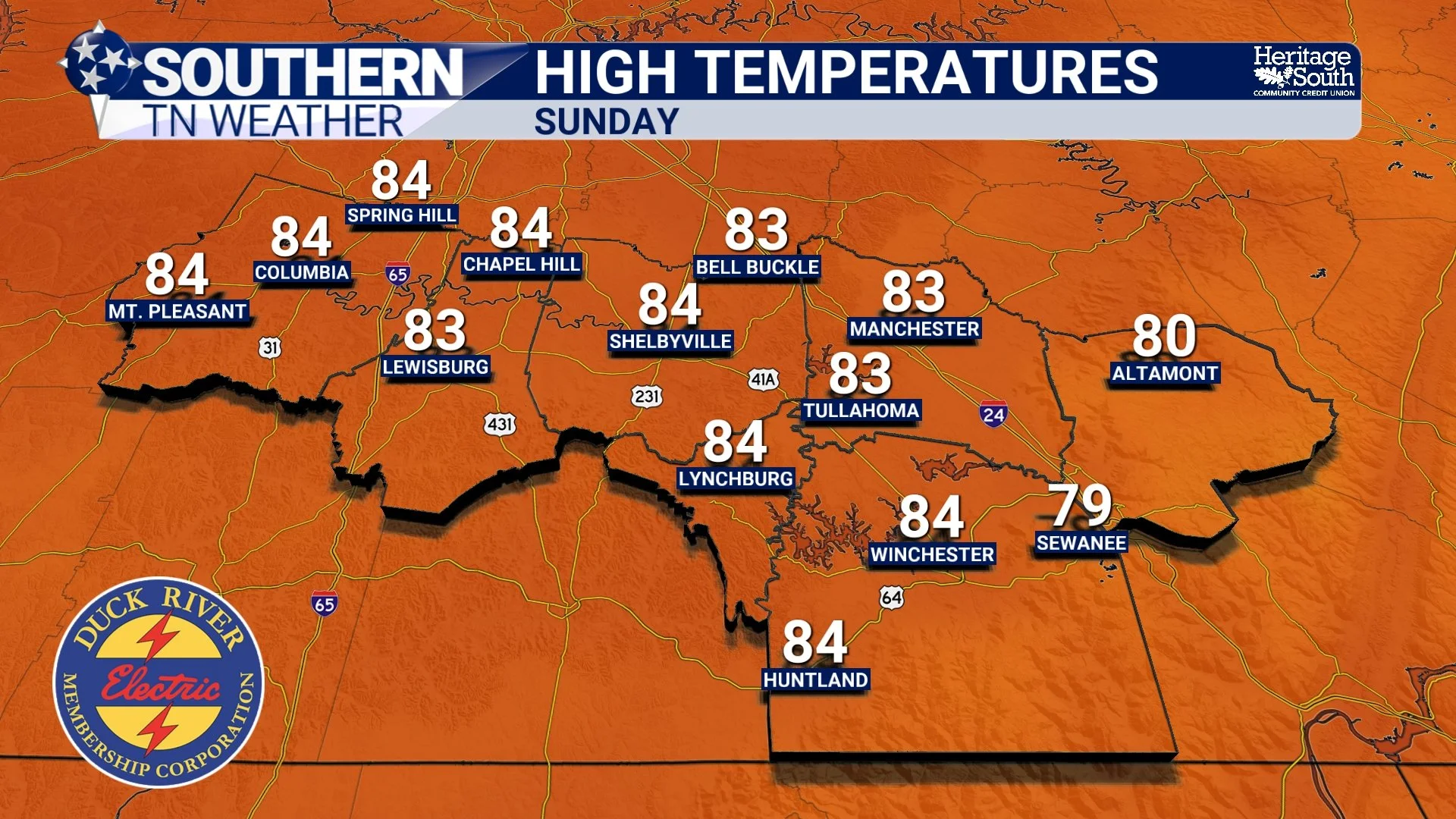
Highs will move through the 70s today and Thursday, then into the 80s by Friday. By the weekend, widespread mid 80s are expected, and a few spots could push even higher.
A Real Shot at Near-Record Heat
By the time we reach the weekend, the ridge becomes the dominant feature across the southeastern United States. With strong April sun, limited cloud cover, and a warming air mass in place, temperatures will have no trouble climbing.
Sunday looks to be the warmest day of the stretch, and there is a legitimate chance some locations challenge long-standing records. Some guidance even suggests a low-end chance of a few areas approaching 90 degrees. For early April, that is significant warmth…
Why the Forecast Remains So Dry
One of the more important takeaways from today’s forecast is just how stubborn this pattern is. Models continue to show systems trying to approach from the west, but weakening as they encounter the ridge. Without strong lift, sufficient moisture, or instability, those systems simply fall apart before reaching us.
There are hints at a potential system sometime around the middle of next week, but confidence remains low. Given the current setup, it would not be surprising if that system weakens as well. In other words, the pattern is not just dry. It is actively preventing rain from reaching us.
The Local Impact
Across Southern Middle Tennessee, this setup translates to several noticeable trends. We will continue to see cool mornings and warm afternoons, especially over the next couple of days. Humidity remains fairly comfortable for now, but will slowly begin to increase as southerly flow strengthens.
Skies will stay mostly sunny with occasional high clouds, and temperatures will climb each afternoon heading into the weekend. And most importantly, rain remains absent from the forecast.
The Bigger Picture
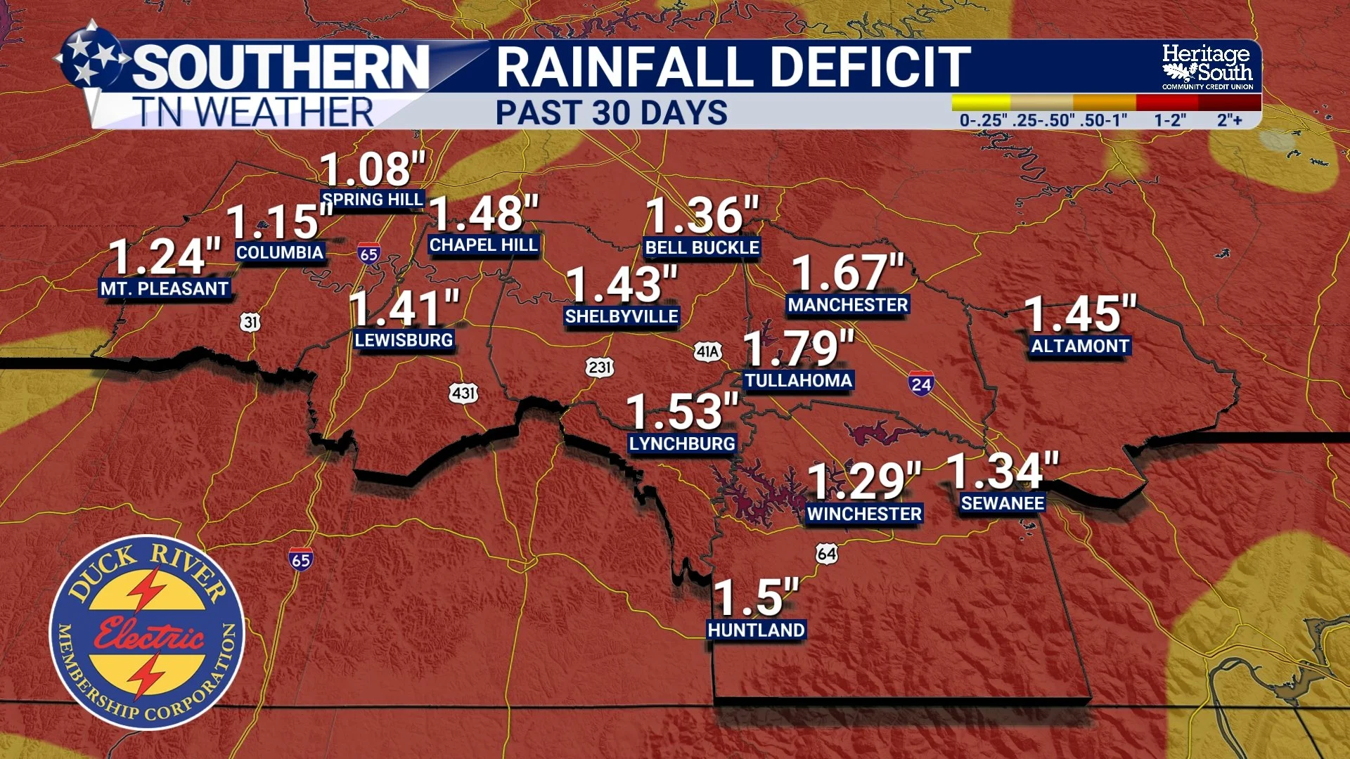
Even though this weather is hard to complain about, there are longer-term concerns. We are now entering another extended stretch without meaningful rainfall. While we did receive some helpful rain recently, it was not enough to completely erase existing deficits. Over the past 30 days, we are in at least a 1-2 inch deficit across the area.
As temperatures rise into the 80s, evaporation rates increase, and soils begin to dry out more quickly. That is how drought conditions can quietly worsen, even during a stretch of otherwise beautiful weather…
The Bottom Line 🧾
• Dry and quiet weather continues
• Warming trend begins and builds into the weekend
• Highs in the 80s with near-record heat possible
• Rain chances remain very low through early next week
📰 Reminder: The Southern Tennessee Weather Blog, presented by Heritage South Community Credit Union, is updated Monday through Friday with fresh, locally tailored forecasts you can trust.