
When Do We Usually See Our First Freeze and Snow?

The Southern Tennessee Weather Blog is proudly presented by Heritage South Community Credit Union.
We Help When Others Won’t!
Visit https://www.heritagesouth.org/ today to see how HSCCU can help YOU!
I know what you're thinking. It's August 25th, temperatures are still pushing toward 90°, and we're already talking about the first FREEZE and SNOW? Don't worry—I'm not forecasting either one anytime soon. But we're approaching the time of year when the days begin getting noticeably shorter, cooler nights become more common, and questions about fall and winter start showing up in my inbox. So today I thought we'd look at the climatology and answer two of those questions: When do we normally see our first freeze, and when does the first snow usually show up?
The graphics accompanying today's blog are based on historical climatology, so they're not predictions for fall or winter 2026. Think of them as a look at what has typically happened over many years. Any individual year can (and absolutely will) behave differently.
The First Freeze Usually Comes in Late October
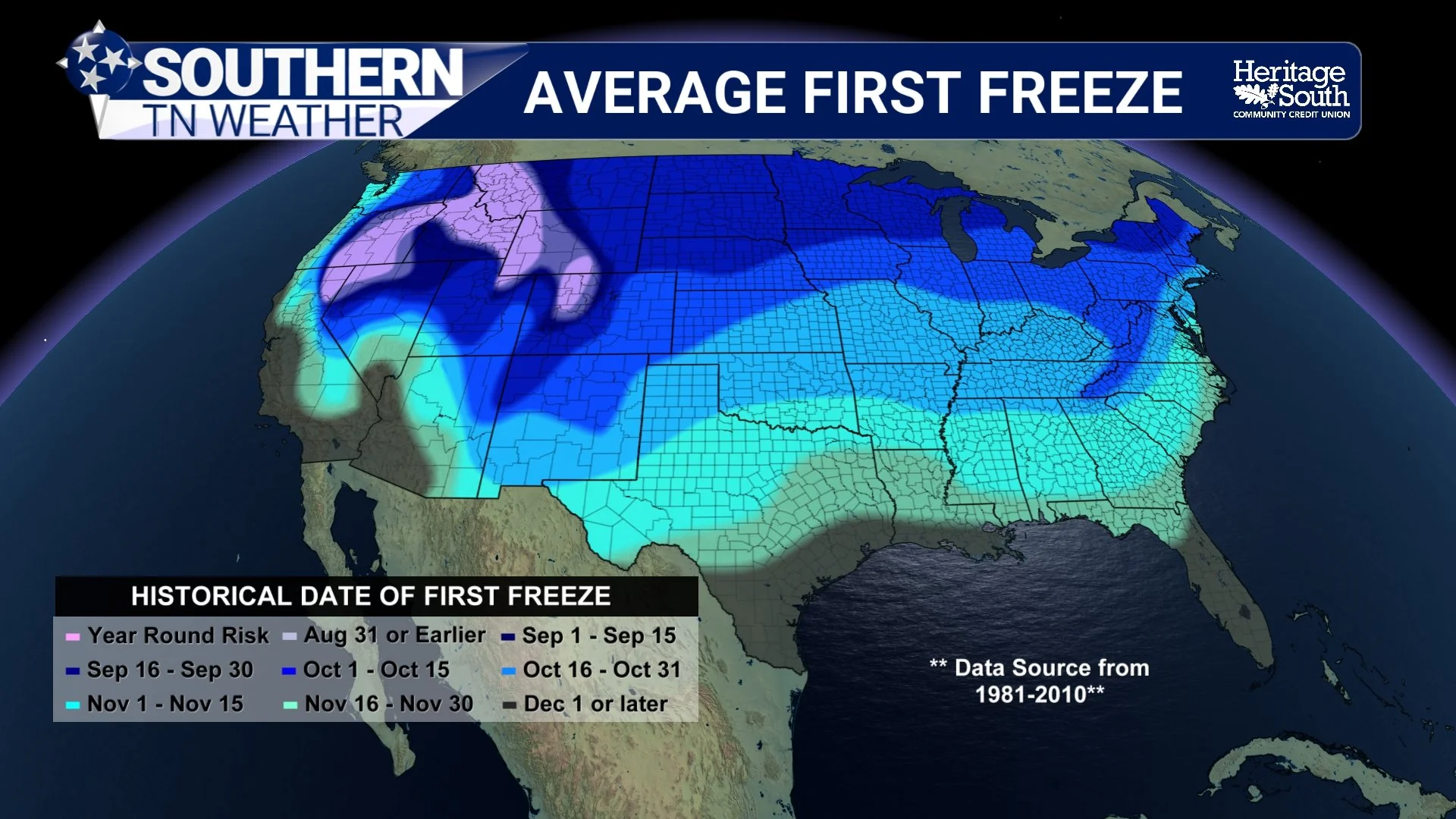
For most of Southern Middle Tennessee, the historical map puts the average first freeze (defined as a temperature of 32° or colder) around October 16 through October 31. In other words, we're typically looking at roughly another two months before freezing temperatures become climatologically common across our area. That doesn't mean October 16 suddenly flips a switch and everybody freezes. An average is simply the midpoint of many years of observations. Some autumns can bring an unusually early shot of cold air, while other years can make it well into November before a particular community reaches 32°.
Terrain also matters tremendously. Rural valleys and sheltered locations can cool much faster on clear, calm nights than hilltops or urban areas. Cold, dense air settles into low-lying locations, which is why one backyard can wake up to frost while another location only a few miles away remains several degrees warmer. The Cumberland Plateau and other higher-elevation locations can also experience colder conditions earlier than surrounding lower elevations depending on the setup.
The broader Tennessee Valley shows just how much first-freeze dates can vary. NWS Huntsville climatology says most locations in the central Tennessee Valley experience their first freeze sometime from mid-October through mid-November. At Huntsville itself, the average is November 2, but the historical range stretches from an October 9 first freeze all the way to December 5. That's a nearly two-month spread! So our late-October shading is useful for planning, but it is certainly not a deadline Mother Nature has to follow. There is also a difference between a freeze and a hard freeze. A freeze occurs at 32° or below, while a hard freeze generally refers to temperatures of 28° or colder. The first 32° morning can end the growing season for sensitive vegetation, but a harder freeze is much more damaging to plants that may survive a brief dip near freezing.
AVERAGE FIRST FREEZE
Snow Usually Makes Us Wait a Little Longer
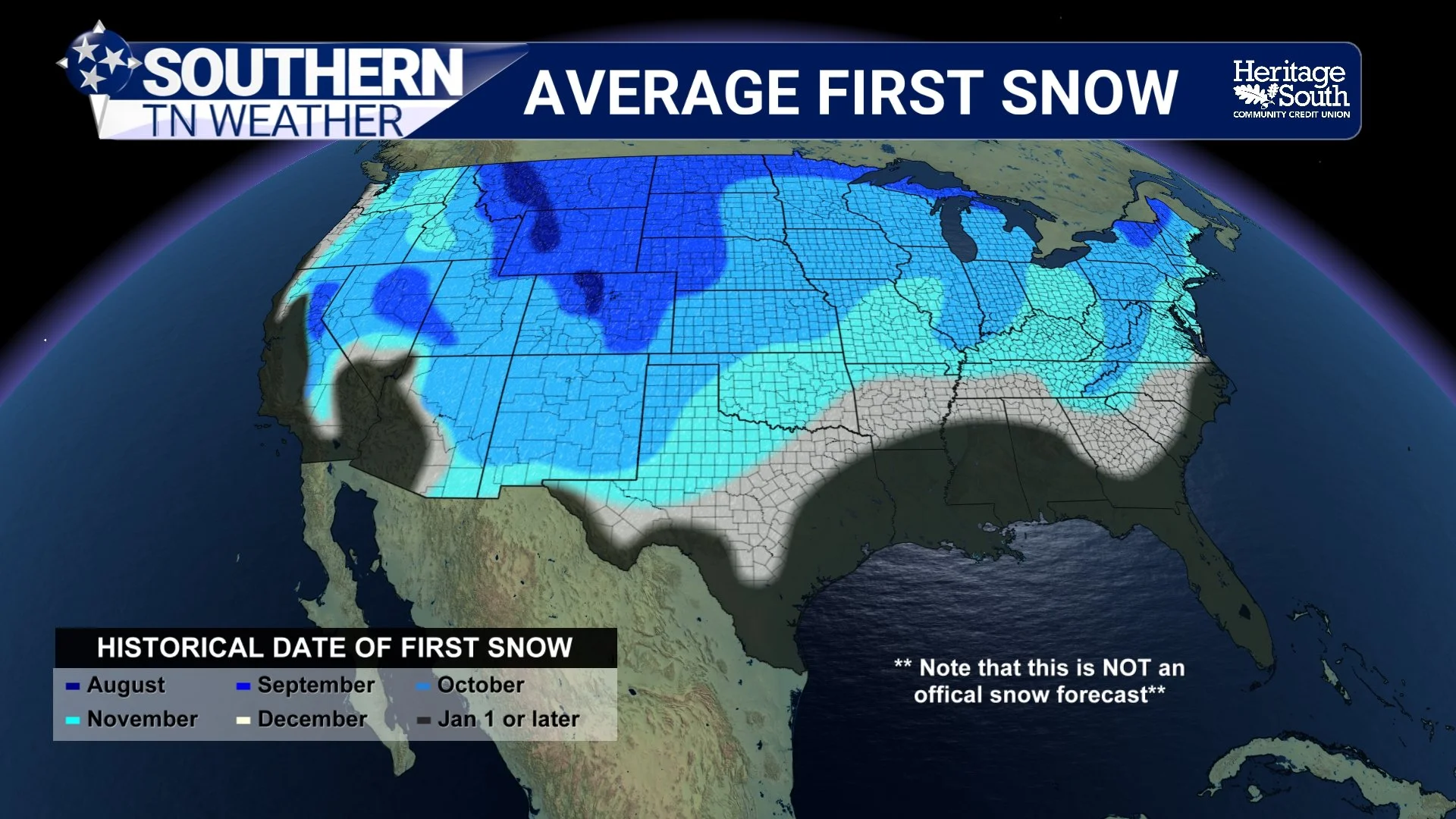
The first-snow map tells a different story. Across most of Southern Middle Tennessee, the historical first snow generally falls during December, while portions of the Cumberland Plateau tend to see their first snow earlier, generally during November. That Plateau difference makes perfect sense after yesterday's blog. Higher elevations around Monteagle and Grundy County are frequently colder than the surrounding lower elevations, and in marginal early-season setups, a difference of only a few degrees can determine whether precipitation reaches the ground as cold rain or snow.
It's also important to define what we mean by “first snow.” A first snow does NOT necessarily mean our first accumulating winter storm. A few flakes, flurries or a trace of snow can qualify climatologically even if absolutely nothing sticks to the ground. That's one reason the first snow can arrive weeks (or sometimes months) before our first meaningful accumulation. Nashville's long-term climate record is a good example. NWS Nashville lists the mean date of the first snowfall greater than a trace as December 23, while measurable November snow is still possible and the city's normal November snowfall is only 0.1 inch. December averages 0.4 inch, with the bulk of Nashville's normal seasonal snowfall actually coming later in January and February.
And the range from year to year is enormous. Nashville's earliest recorded first snow greater than a trace occurred on October 31, 1993. In another season, the first qualifying snow didn't arrive until March 12, 1992. That's a great reminder of why an “average first snow” map should never be mistaken for a winter forecast. So if we reach December 1st without seeing a flake, winter isn't “running late.” Likewise, if we somehow see flakes in November, that doesn't automatically mean we're in for a brutal or snow-filled winter. The timing of the first snow tells us very little about what the rest of the season will ultimately bring.
AVERAGE FIRST SNOW
Freeze First, Snow Later
Put the two maps together and you can see the normal progression into our cold season pretty clearly. Freezing temperatures usually arrive first, generally during the second half of October across Southern Middle Tennessee. Our first flakes typically require us to wait several more weeks, with November favored on the Plateau and December favored for much of the rest of the area. Of course, Tennessee weather has never been particularly interested in following averages perfectly. We can still have warm afternoons well into the fall after our first freeze, and we've certainly had winters where snow arrived unusually early—or barely arrived at all.
That's what makes climatology useful. It doesn't tell us exactly what WILL happen this year; it gives us a baseline for understanding whether something happens unusually early, unusually late or pretty much right on schedule. And before anyone starts stocking up on bread and milk after seeing the snow graphic: this is NOT a snow forecast! We'll have plenty of time to talk about the actual winter forecast later.
A Quick Look at the Actual Forecast
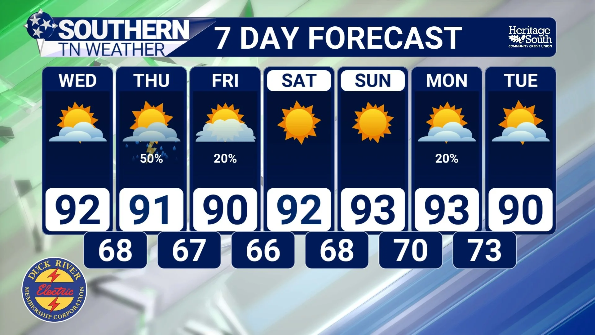
There certainly isn't anything wintry about our current forecast. High pressure is giving Southern Middle Tennessee one more relatively pleasant August day, with cooler and drier air hanging around thanks to northeasterly flow. Tonight should be comfortable again, with temperatures falling into the 60s beneath generally quiet conditions. Changes begin Wednesday as a weak surface low and frontal boundary start influencing the region. Forecast confidence in the exact timing is fairly low because the high-resolution models disagree considerably on when individual rounds of showers and thunderstorms will develop. At this point, Wednesday doesn't look like a washout, and the better opportunity for rain across much of Middle Tennessee appears to arrive Wednesday night into Thursday.
Scattered showers and thunderstorms will be possible during that period. Widespread severe weather is not currently expected, but a few stronger storms could produce gusty winds, frequent lightning and locally heavy rainfall. The Huntsville forecast office also notes that if enough instability develops during the afternoon, a few stronger storms can't be ruled out across portions of the Tennessee Valley. We'll keep an eye on how that evolves as newer data arrives.
The front should finally clear the region Thursday night into Friday, allowing rain chances to decrease. The weekend currently looks mainly dry with temperatures pretty close to normal for late August—generally around 90° to the lower 90s during the afternoon. Unfortunately for everyone already dreaming about those October freezes, summer may have another trick up its sleeve next week. Upper-level ridging is expected to strengthen again, and temperatures could climb back into the middle 90s in spots early next week. It's still too early to know exactly how hot we'll get, but another period of notable heat may need to be watched by Monday and Tuesday.
STNWX 7-DAY FORECAST
The Bottom Line 🧾
🥶 Average first freeze: For much of Southern Middle Tennessee, climatology favors October 16–31 for the first temperature of 32° or colder.
🌡️ It's only an average: Local terrain and the weather pattern can make the first freeze several weeks earlier or later in any particular year.
❄️ Average first snow: The Cumberland Plateau generally sees its first snow sometime in November, while December is more typical across most of the rest of Southern Middle Tennessee.
🌨️ First snow doesn't mean a snowstorm: Flurries or a small amount of snow can count as the season's first snow without producing meaningful accumulation.
📊 This is climatology, NOT a winter forecast: The maps show what has historically happened, not when our first freeze or snow will occur in 2026.
⛈️ Wednesday night–Thursday: Scattered showers and thunderstorms return, with gusty winds and locally heavy rainfall possible in stronger storms.
🌤️ Weekend: Mainly dry and seasonable weather returns.
🥵 Early next week: Temperatures may begin climbing again, with another stretch of hotter weather possible.
📰 Reminder: The Southern Tennessee Weather Blog, presented by Heritage South Community Credit Union, is updated Monday through Friday with fresh, locally tailored forecasts you can trust.
