
Why Is the Cumberland Plateau’s Weather So Different?

The Southern Tennessee Weather Blog is proudly presented by Heritage South Community Credit Union.
We Help When Others Won’t!
Visit https://www.heritagesouth.org/ today to see how HSCCU can help YOU!
If you've followed Southern Tennessee Weather for very long, you've probably noticed that I sometimes treat the Cumberland Plateau almost like its own little weather world. It can be near 90° in Winchester while Monteagle is several degrees cooler. Most of Southern Middle Tennessee can be dry while showers keep trying to bubble up around Grundy County. And during the winter, you can leave lower elevations with plain rain only to find a completely different situation after climbing Monteagle. 😂
You can travel only 20 or 30 miles and seemingly enter a different forecast. So why does the Cumberland Plateau's weather behave so differently? Most of the answer comes down to one thing: terrain.
WEATHER WHY
A Different Landscape Means Different Weather
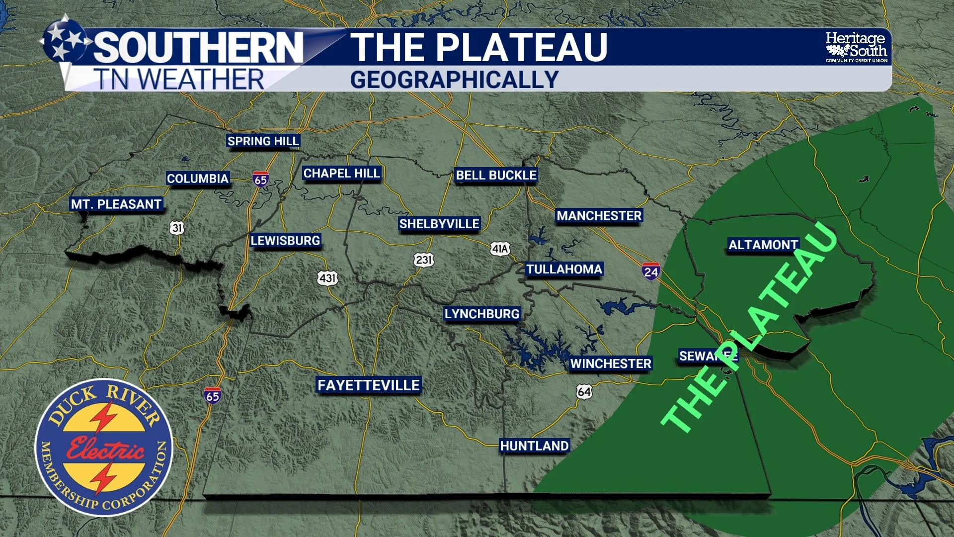
The Cumberland Plateau is an elevated region stretching from Kentucky through Tennessee and into Alabama. Across our part of Tennessee, elevations around Monteagle and portions of Grundy County are roughly 2,000 feet above sea level, considerably higher than many communities immediately to the west.
That elevation matters because temperature generally decreases as you climb through the lower atmosphere. The exact difference changes from day to day depending on moisture, wind and atmospheric stability, but the basic result is easy to see in our forecasts: the Plateau is frequently several degrees cooler than the lower elevations around it.
That's why a summer forecast might call for highs around 90–92° across much of Southern Middle Tennessee while portions of the Plateau remain in the middle or upper 80s. It's also why winter weather becomes especially interesting. When temperatures are hovering just above freezing in Winchester, a few degrees of cooling with elevation can sometimes be enough for snow, sleet or freezing conditions around Sewanee and Monteagle.
THE PLATEAU
Why Showers Seem to Love the Plateau
Temperature isn't the only difference. The terrain itself can actually help air rise through a process called orographic lift. When moving air encounters higher terrain, it can be forced upward. As that air rises, it expands and cools. If enough moisture is present, that extra lift can help clouds, showers and thunderstorms develop. Think of the Plateau as a speed bump for the atmosphere: on certain days, the terrain provides just enough additional upward motion to get things going.
This becomes especially noticeable during the summer when we don't have a strong cold front or storm system providing obvious lift. On a marginal afternoon, the combination of terrain, differential heating and available moisture can make the Plateau one of the favored areas for pop-up convection. That's why you'll occasionally see me forecast a 20% rain chance for much of the area but bump it noticeably higher around the Plateau.
Over time, those terrain effects add up. National Weather Service climatology shows annual precipitation increasing toward the southern Cumberland Plateau, with more than 60 inches per year around the Monteagle area. So when it seems like the Plateau gets a little extra help squeezing rain out of the atmosphere, there's climatology behind that observation too.
Fog, Cold Nights and Winter Weather
The Plateau's complicated terrain also creates plenty of valleys, hollows and sheltered locations where colder air can settle at night. Under clear skies and light winds, the ground loses heat and colder, denser air drains into lower spots. If temperatures cool close enough to the dew point, fog can develop. That's one reason fog can be extremely localized across our region—one valley can be socked in while a nearby ridge remains perfectly clear.
Winter magnifies all of these differences. Elevation can mean colder surface temperatures, and terrain can enhance precipitation when the wind direction is favorable. In a borderline setup, that can be the difference between wet roads and icy roads, or between rain and accumulating snow. It's why I pay especially close attention to Grundy County and the Monteagle area anytime we're dealing with marginal winter weather.
One thing the terrain does NOT do, however, is magically protect the Plateau from severe weather. You've probably heard someone say that Monteagle will “break up” a storm. Terrain can influence low-level winds and interact with thunderstorms, but severe storms and tornadoes can absolutely cross the Plateau. The interaction between storms and complex terrain is much more complicated than simply saying a mountain will tear a storm apart.
So when Grundy County gets a slightly different temperature, rain chance or winter forecast on one of my graphics, there's a reason for it. The elevation changes temperature, the terrain can enhance lift and precipitation, valleys influence nighttime cooling and fog, and winter precipitation can behave very differently over only a short distance. The Cumberland Plateau really does live in its own little weather world.
A Quick Look at the Forecast
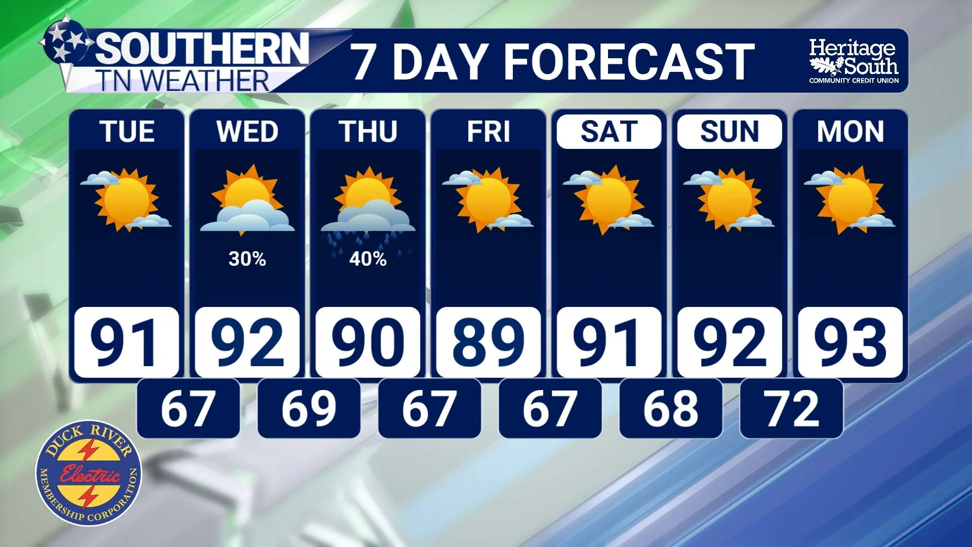
Coincidentally, today's weather gives us another nice example of those elevation differences. High pressure is delivering a fantastic start to the week, with mostly sunny skies, light north to northwest winds and highs generally in the upper 80s to around 90°. The Plateau should once again run a few degrees cooler.
The bigger story is the humidity. Dew points are only in the upper 50s and lower 60s for many locations, making the air considerably more comfortable than the oppressive humidity we've dealt with for much of August. Tonight should cool efficiently beneath mostly clear skies and light winds, with most of us falling into the middle 60s while some of the cooler Plateau locations could reach the upper 50s. Patchy fog will also be possible in river valleys and other low-lying areas late tonight into early Tuesday.
Tuesday is essentially a repeat: mostly sunny, highs around 90° and relatively comfortable humidity. Changes begin Wednesday as moisture increases and a boundary approaches the Tennessee Valley. Isolated to scattered showers and thunderstorms become possible Wednesday afternoon and evening, and a few storms could produce gusty winds and locally heavy rainfall. Rain chances continue Wednesday night into Thursday before gradually tapering as the system moves east.
After that, the forecast settles down again. Friday through the weekend currently looks mainly dry with highs in the upper 80s and lower 90s and overnight lows generally in the 60s. Temperatures may begin creeping upward again early next week, but for late August, this is a pretty manageable stretch of weather.
STNWX 7-DAY FORECAST
The Bottom Line 🧾
⛰️ The Plateau really does have different weather: Higher elevation makes a meaningful difference in temperatures, precipitation and winter weather.
🌡️ It's frequently cooler: Monteagle and surrounding higher terrain often run several degrees cooler than lower elevations.
🌧️ Terrain can help produce rain: Orographic lift can favor clouds, showers and thunderstorms around the Plateau.
🌫️ Fog can be very localized: Valleys and hollows collect cooler air overnight, helping fog develop in favored locations.
❄️ Winter weather can change quickly with elevation: Rain at lower elevations can sometimes become snow, sleet or freezing rain on the Plateau.
☀️ Monday and Tuesday: Mostly sunny, comfortable and mainly dry with highs around the upper 80s to lower 90s.
⛈️ Wednesday and Thursday: Scattered storms return, with locally heavy rainfall and a few stronger storms possible.
🌤️ Friday through the weekend: Mainly quiet weather returns with temperatures close to seasonal norms.
📰 Reminder: The Southern Tennessee Weather Blog, presented by Heritage South Community Credit Union, is updated Monday through Friday with fresh, locally tailored forecasts you can trust.
