
Who’s Driving This Thing? What Actually Steers a Tropical System?

The Southern Tennessee Weather Blog is proudly presented by Heritage South Community Credit Union.
We Help When Others Won’t!
Visit https://www.heritagesouth.org/ today to see how HSCCU can help YOU!
Whenever we're tracking something tropical in the Gulf, one question inevitably becomes more important than almost everything else: Where is it going? It sounds like a simple question. If we know where a tropical system is located and which direction it's moving right now, shouldn't we be able to draw a line forward and figure out where it'll go next? Not exactly.
Tropical systems don't have an engine, a steering wheel or a destination programmed into GPS. Instead, they're carried around the atmosphere by the larger-scale winds surrounding them. Meteorologists often call this the steering flow, and understanding that flow is one of the most important parts of forecasting where a tropical system will eventually travel. That's especially relevant for us this week. Invest 92L remains in the Gulf, and forecast guidance is increasingly interested in bringing tropical moisture northward toward the Gulf Coast and eventually portions of the Southeast this weekend. Exactly how far north the system gets, however, may depend on another weather feature hundreds of miles away. So, what exactly is steering this thing?

BLOG TITLE PAGE
Think of a Tropical System Like a Leaf Floating Down a River
One of the easiest ways to understand tropical steering is to imagine dropping a leaf into a river. The leaf can wobble around, rotate and move differently within small currents, but its overall journey is largely controlled by the much bigger flow of water around it. A tropical cyclone behaves somewhat similarly, except its "river" is the atmosphere. Large areas of high and low pressure create broad wind patterns thousands of feet above the ground. A tropical system becomes embedded within those winds and is generally carried along with them. That's why meteorologists spend so much time looking far beyond the tropical disturbance itself when trying to forecast its eventual track.
One of the biggest players is often a large area of high pressure known as a subtropical ridge. In the Atlantic, you've probably heard meteorologists talk about the Bermuda High. Winds circulate clockwise around high pressure in the Northern Hemisphere, and the position and strength of that ridge can have a tremendous influence on tropical tracks. If a strong ridge is positioned north of a tropical cyclone, it can essentially block the storm from turning northward and keep pushing it farther west. If that ridge weakens or develops a gap, the storm may find an opportunity to begin turning north. That's where troughs become important.
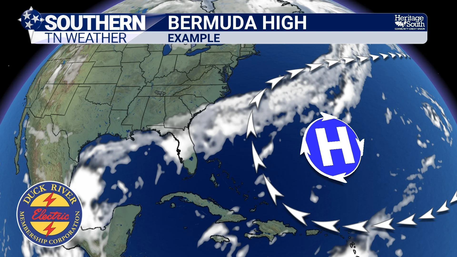
BERMUDA HIGH - EXAMPLE
High Pressure Can Block. Troughs Can Create an Escape Route.
A trough is an elongated area of relatively lower pressure in the atmosphere, often associated with dips in the jet stream and changing weather across the United States. Troughs can weaken the ridge surrounding a tropical system and alter the steering winds enough to pull or guide the system northward. You can almost think of the ridge as a guardrail. As long as the guardrail remains strong and intact, the tropical system tends to keep following it. Introduce a weakness into that ridge, however, and suddenly there's another route available.
The exact timing matters tremendously. If a trough approaches quickly enough, it may create that weakness at exactly the right time for a tropical system to begin moving north or northeast. If the trough is slower, weaker or positioned differently, the tropical system may remain farther south or west.
Sometimes we're talking about relatively small timing differences in one weather system producing enormous differences in another system several days later. And that's a BIG part of what we're watching with Invest 92L right now.
Invest 92L Is a Great Real-World Example
Forecast models have increasingly shown solutions in which Invest 92L develops and eventually moves north toward the Gulf Coast, but there's an important difference between the scenarios. A shortwave trough is forecast to move through Texas Friday into Saturday. A shortwave is essentially a smaller-scale disturbance or ripple moving through the larger atmospheric flow. Despite being considerably removed from Invest 92L initially, the timing of that disturbance could have a major influence on what eventually happens in the Gulf.
If the shortwave progresses quickly enough, forecast guidance suggests it could interact, or phase, more effectively with Invest 92L. Phasing basically means two separate atmospheric features begin interacting and working together within the larger weather pattern. In that scenario, the tropical disturbance could be encouraged to move northward more aggressively, bringing considerably more Gulf moisture toward the Southeast and potentially Southern Middle Tennessee.
If the shortwave moves more slowly, that interaction may not happen nearly as effectively. Invest 92L could remain less organized and make considerably less progress northward. So when you see dramatically different model tracks for a tropical system, it doesn't necessarily mean one computer model has completely lost its mind. Sometimes they're handling another feature differently, and that difference eventually changes the steering flow around the tropical system. It's basically atmospheric dominoes. Change one piece over Texas on Friday and you could eventually change what happens hundreds of miles away in Southern Middle Tennessee this weekend.
Stronger Storms Can Sometimes Feel Different Steering Winds
There's another wrinkle that makes tropical forecasting interesting: not every tropical system is steered by exactly the same layer of the atmosphere. A weak, shallow tropical disturbance may primarily respond to winds relatively low in the atmosphere. A strong, deep hurricane extends much farther vertically and can respond to a deeper average of the surrounding atmospheric flow.
Imagine two boats in moving water. One barely extends beneath the surface while another has a much deeper structure beneath it. They're both being carried by the current, but they're interacting with different portions of that current. That's one reason the eventual organization and intensity of a tropical system can sometimes influence its track. Track affects intensity, but intensity can also affect which steering currents have the greatest influence on the storm. That doesn't mean a hurricane suddenly decides where it wants to go. The atmosphere is still doing the steering. The storm is simply interacting with a deeper portion of it.
Why Can't We Just Trust the Spaghetti Models?
This is also why those famous tropical "spaghetti plots" need some context. Each line represents a possible track based on a particular model or ensemble member. When those lines cluster tightly together, confidence in the general track may be increasing. When they spread apart dramatically, that tells us there are important disagreements about the atmospheric pattern. But the tracks themselves don't explain why they're different.
Maybe one model makes the ridge stronger. Another weakens it sooner. Maybe one brings a trough through faster. Another keeps it farther west. Perhaps one model develops the tropical system more quickly, allowing it to interact with a different depth of the steering flow. Those differences can initially seem tiny. Give them several days, and suddenly one model has a tropical system approaching Louisiana while another has it moving toward Florida. That's also why you shouldn't simply count spaghetti lines and assume whichever destination has the most lines automatically wins. Meteorologists have to examine the atmospheric pattern responsible for producing those tracks.
We're not simply asking: “Where does the model say the storm goes?” We're asking: “WHY does the model take the storm there, and does the atmospheric setup responsible for that track make sense?” That's a much more useful question.
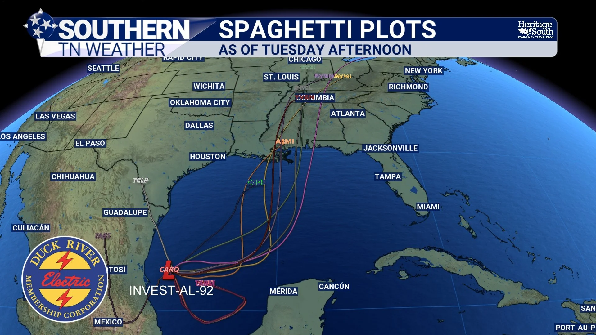
SPAGHETTI PLOTS
The Storm Doesn't Exist in a Bubble
This is probably the biggest takeaway from today's blog. When meteorologists forecast a tropical system, we're not staring exclusively at the Gulf or Atlantic. We might be watching high pressure over the western Atlantic, a trough digging through the central United States, a shortwave crossing Texas or another feature thousands of miles away. All of those pieces can eventually alter the atmospheric highway available to a tropical system. And the farther into the future we look, the more uncertainty there is regarding exactly how those pieces will fit together.
That's particularly true when we're dealing with a disturbance that is still organizing. Until a well-defined circulation develops, models can have a more difficult time initializing exactly what they're trying to forecast. As the system becomes better organized and additional observations become available, we can generally begin narrowing down the possibilities. That's why our message on Invest 92L has remained relatively consistent: watch the overall trend, but don't become married to one exact track yet.
What Does This Mean for Southern Middle Tennessee?
While the exact evolution of Invest 92L remains uncertain, confidence is increasing that Gulf moisture will return northward this weekend. The latest forecast now calls for medium rain chances below 60%, and current guidance supports at least around 0.75 inch of rainfall across the area, with the potential for a few locations to receive several inches depending on how the tropical moisture ultimately evolves. That's certainly encouraging considering our ongoing drought.
However, those rainfall amounts are NOT locked in. How Invest 92L develops, where it moves, how quickly the Texas shortwave progresses and how effectively those two features interact will all help determine where the deepest tropical moisture eventually travels. A farther north track or stronger interaction could bring considerably more moisture into Southern Middle Tennessee. A weaker system or less favorable interaction could keep the better rainfall farther south.
This is exactly why we're watching the pattern instead of obsessing over one model run. Before any of that happens, we've got several beautiful days ahead. High pressure will keep Southern Middle Tennessee dry through Friday, with plenty of sunshine and highs generally in the low to mid 80s Tuesday and Wednesday, eventually warming into the mid to upper 80s later this week. A few of our warmer locations could even flirt with 90 degrees Thursday. Thankfully, humidity will remain relatively comfortable. Overnight lows will generally fall into the upper 40s and 50s, with our typically cooler valleys and higher elevations having the best opportunity to dip toward the lower end of that range. Then our attention turns squarely toward the Gulf.
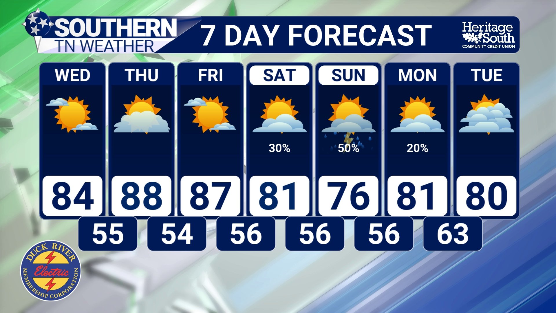
STNWX 7-DAY FORECAST
The Bottom Line 🧾
🌀 Tropical systems are primarily steered by the larger-scale winds surrounding them, not by anything happening within the storm that allows it to choose its own direction.
🏔️ Large areas of high pressure can act like atmospheric guardrails, while troughs can create weaknesses that allow tropical systems to turn northward.
⏱️ Timing is incredibly important. A trough arriving a little faster or slower can eventually produce a dramatically different tropical track.
🧩 With Invest 92L, we're closely watching a shortwave expected to move through Texas Friday into Saturday. A faster shortwave could interact more effectively with the tropical disturbance and encourage greate
northward movement.
🌊 A slower interaction could leave the disturbance less organized and farther south.
🌀 The strength and depth of a tropical cyclone can also affect which layers of atmospheric steering flow influence it most.
🍝 Spaghetti models show possible tracks, but understanding why those tracks differ is far more important than simply counting lines.
☀️ Southern Middle Tennessee remains dry through Friday with warm afternoons and cool, comfortable nights.
🌧️ Rain chances increase this weekend as Gulf moisture moves northward, with the potential for beneficial rainfall if the current pattern holds.
👀 Exactly how much rain reaches us will depend heavily on how the tropical system and surrounding atmospheric features evolve over the next several days.
📰 Reminder: The Southern Tennessee Weather Blog, presented by Heritage South Community Credit Union, is updated Monday through Friday with fresh, locally tailored forecasts you can trust.
