
Isaias Is Coming: What Can We Expect Here at Home?

The Southern Tennessee Weather Blog is proudly presented by Heritage South Community Credit Union.
We Help When Others Won’t!
Visit https://www.heritagesouth.org/ today to see how HSCCU can help YOU!
Things are getting considerably more interesting in the Gulf. Tropical Storm Isaias continues to organize Wednesday afternoon, and the National Hurricane Center expects it to strengthen significantly as it moves across the Gulf over the next couple of days. As of the 10 AM update, Isaias had maximum sustained winds of 45 MPH and was moving east-northeast at around 8 MPH. Hurricane Hunters have also found that the circulation is becoming better organized, and the storm is expected to gradually turn northward and accelerate toward the northern Gulf Coast.
The current forecast strengthens Isaias into a hurricane Thursday and brings it to around 110 MPH Friday morning, which would make it a strong Category 2 hurricane. Some weakening is possible as the storm approaches the coast Friday evening, but exactly how much weakening occurs remains uncertain. Isaias is also expected to grow in size as it begins interacting with an approaching trough, meaning impacts along the Gulf Coast could extend well away from the exact center.
For anyone currently along the northern Gulf Coast for fall break, this is obviously a MUCH more serious situation than what we're expecting here at home. Hurricane and Storm Surge Watches are in effect across a large portion of the northern Gulf Coast, where potentially life-threatening storm surge, hurricane-force winds and heavy rainfall will all be possible near and east of wherever the center eventually makes landfall.
Here in Southern Middle Tennessee, we're not worried about anything remotely resembling a hurricane by the time Isaias reaches our latitude. The system will weaken considerably after moving inland, but it won't simply disappear. Confidence continues to increase that the remnants will bring a period of soaking tropical rainfall and gusty winds to our area this weekend, with the primary window currently looking like Saturday afternoon through early Sunday.
The Exact Track Will Determine A LOT
The biggest remaining question for Southern Middle Tennessee is exactly where the remnant circulation travels after landfall. The National Hurricane Center expects Isaias to accelerate northward as it interacts with an approaching trough, and by Saturday the system should be moving fairly quickly from the Gulf Coast toward the Mid-South and Tennessee. That faster movement means our period of impacts should be relatively concentrated rather than lasting for several days.
Even so, relatively small changes in the track could produce noticeable differences in our weather. If Isaias makes landfall farther west and the remnant center tracks through eastern Mississippi or western portions of Tennessee, Southern Middle Tennessee would spend more time on the eastern side of the circulation. That's generally the wetter and more meteorologically active side of a northward-moving tropical system, where deeper moisture, stronger low-level winds and a somewhat more favorable environment for brief tornadoes can develop.
If Isaias tracks farther east through Alabama, portions of our area could end up closer to the western side of the circulation or within a developing dry slot. That could reduce rainfall totals in some locations while keeping the better thunderstorm and tornado environment farther south and east. This is why a 50- or 100-mile adjustment in the eventual track could matter quite a bit for what we experience here at home.
The good news is that we're getting much closer to the point where those details should begin coming into better focus. Isaias is becoming better organized, Hurricane Hunters are sampling the storm, and the overall atmospheric pattern responsible for steering it northward is becoming clearer. Still, we're not quite at the point where I would lock in one exact track through our region.
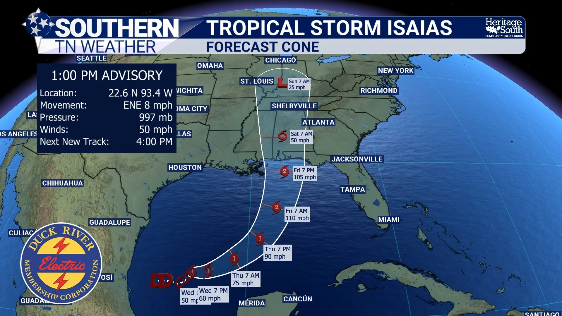
TROPICAL FORECAST CONE
Soaking Tropical Rain Looks Increasingly Likely
Regardless of some of those smaller track differences, rainfall is looking increasingly likely to be our most widespread impact. We’re currently calling for approximately 1 to 3 inches of rain, with areas west of I-65 currently having the greatest probability of reaching or exceeding 2 inches. Some locations could receive more if heavier tropical rain bands repeatedly move across the same areas.
Considering the drought we've been dealing with, much of this rainfall would be VERY beneficial. We've spent the past several weeks talking about rainfall deficits, worsening drought conditions, low streamflows and increasingly dry soil. A widespread one to three inches certainly wouldn't erase every longer-term drought concern, but it would make a substantial dent in the short-term dryness and provide some badly needed moisture across Southern Middle Tennessee.
The first outer bands of rain could begin reaching portions of the region Friday night or Saturday morning, but the main period of widespread rainfall currently looks more likely Saturday afternoon into Saturday night. Tropical systems contain tremendous amounts of moisture, so periods of moderate to heavy rainfall will be possible as Isaias moves northward. The system should also be moving fairly quickly by that point, which could help limit how long the heaviest rain remains over any one location.
That faster movement is important because the biggest flooding problems with tropical systems often occur when they slow down and repeatedly dump heavy rain over the same areas. Isaias doesn't currently look like that type of setup for Southern Middle Tennessee. However, tropical rain bands can still produce very high rainfall rates, and if bands repeatedly move over the same location, localized flooding could develop despite the system's faster overall movement.
For now, I would characterize our flooding concern as low, but not zero. Poor-drainage areas, low-lying locations and places that receive repeated heavier bands would have the greatest chance of experiencing problems. The Weather Prediction Center is also monitoring the broader excessive-rainfall threat as Isaias moves inland, and exactly where the greatest flooding concern develops will become clearer as the track is refined.
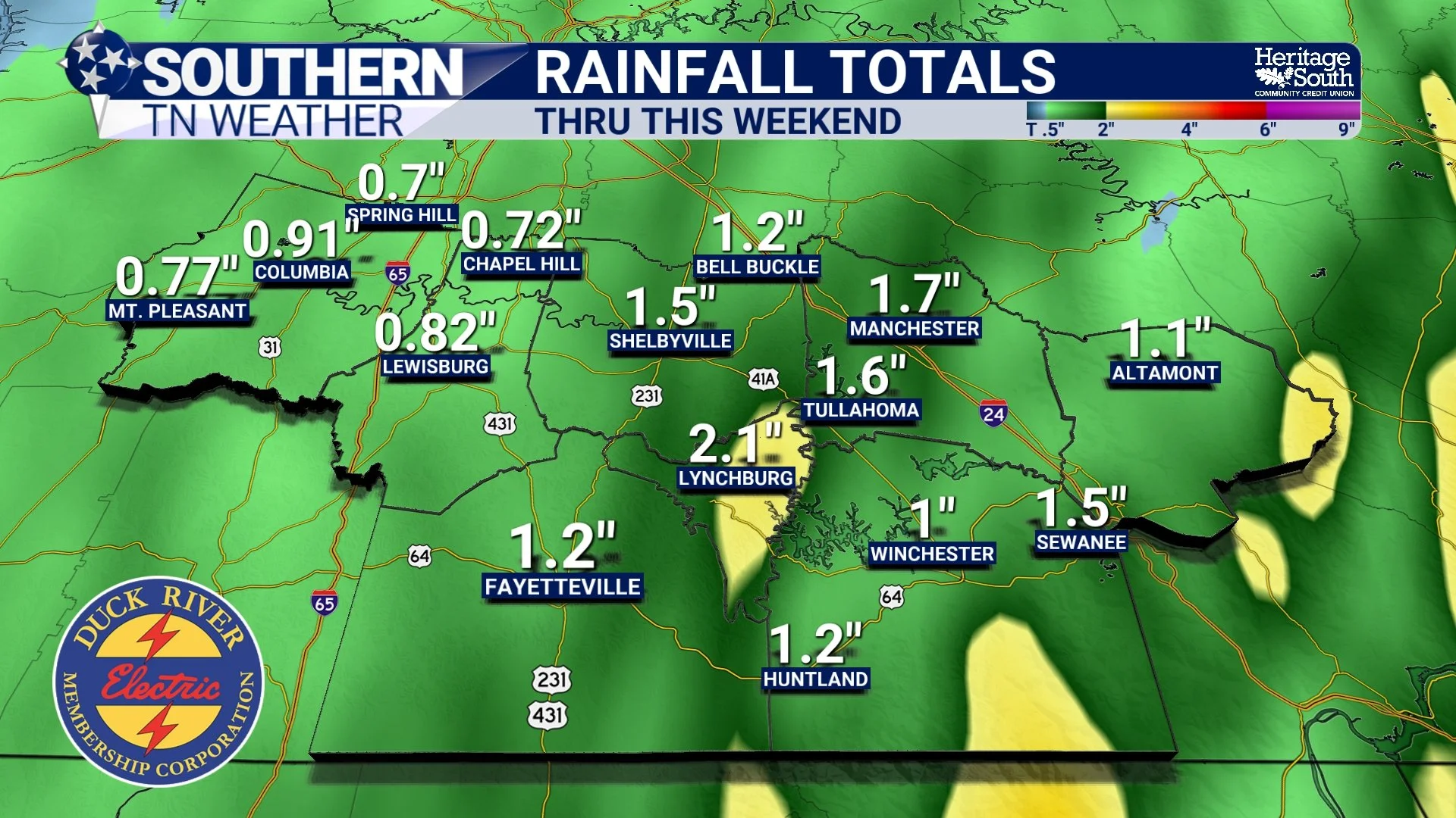
RAINFALL FORECAST - THRU THE WEEKEND
Saturday Could Be Pretty Windy, Too
Rain isn't the only impact we're watching. Even though Isaias will weaken rapidly after moving inland, the circulation itself will still be moving quickly northward while interacting with the larger weather system responsible for pulling it away from the Gulf Coast. That interaction can maintain a fairly strong pressure gradient and allow gusty winds to continue well inland after the system is no longer a hurricane or tropical storm. We’re currently forecasting 30-40 MPH wind gusts.
To be clear, we're NOT currently expecting widespread hurricane-force or tropical-storm-force winds across Southern Middle Tennessee. Instead, Saturday could become a very breezy to windy and rainy day, with occasional stronger gusts as the remnant circulation passes nearby. Gusts in the 30 to 40 MPH range would be enough to blow around unsecured outdoor objects, bring down a few smaller tree limbs and potentially produce isolated power outages.
There's also an interesting relationship between the rain and wind. As the ground becomes wetter, trees can sometimes become easier to uproot during stronger wind gusts, particularly if soils become saturated. I'm not expecting widespread tree damage based on the current forecast, but it's another reason we'll be watching how much rain falls before the strongest winds arrive. If you've got patio furniture, umbrellas, Halloween decorations, trash cans or anything else outside that doesn't particularly enjoy flying, Friday would be a good time to secure it.
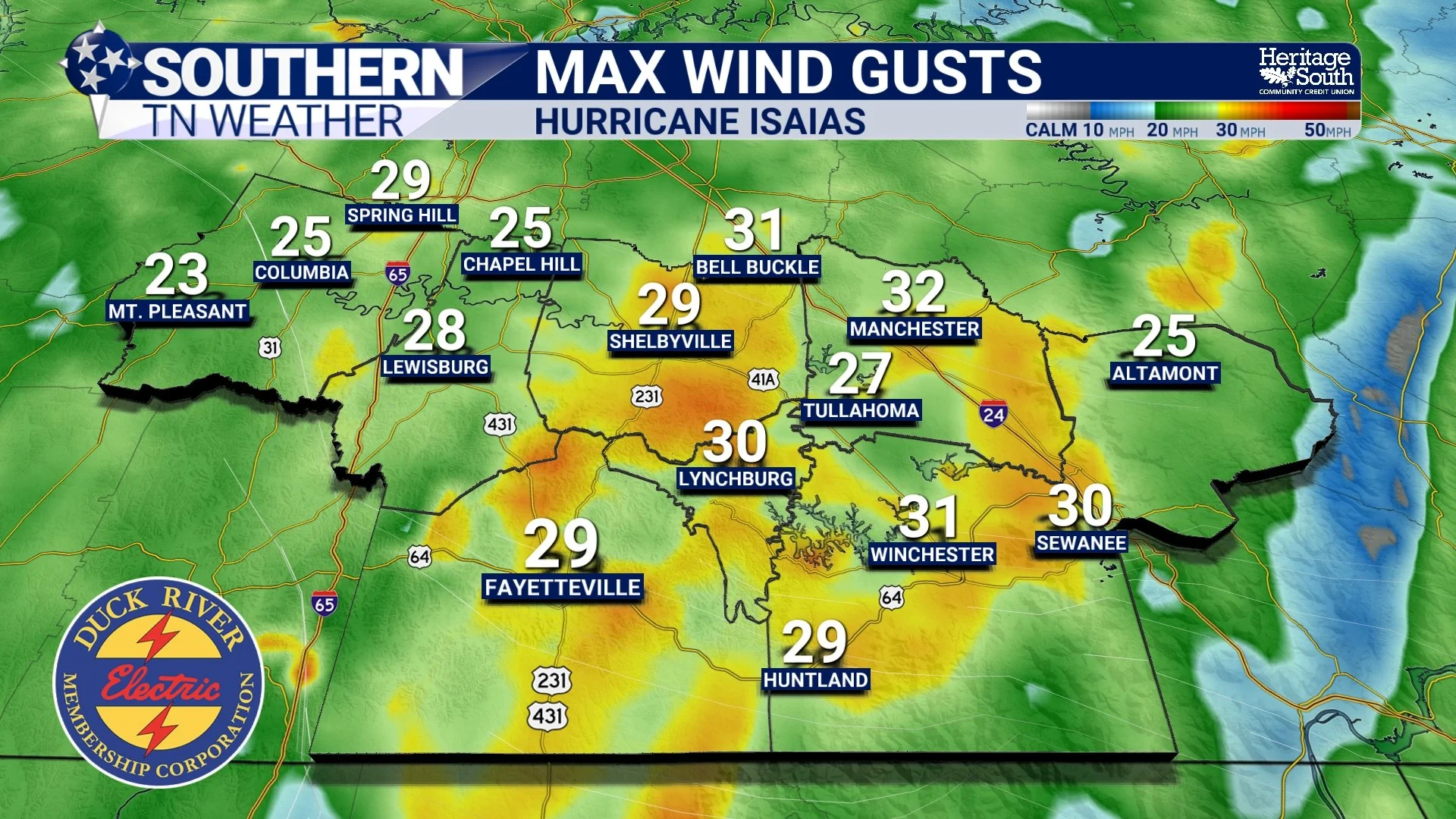
MAX WIND GUSTS - THROUGH THE WEEKEND
What About Tornadoes?
This will probably become one of the biggest questions over the next couple of days because tropical systems are well known for producing brief tornadoes. The answer right now is that a tornado threat is possible, but it currently appears LOW for Southern Middle Tennessee. Tropical systems bring tremendous amounts of low-level wind shear. In simple terms, winds can change speed and direction very quickly as you move upward through the lowest portions of the atmosphere. That creates plenty of spin near the ground, and individual showers or thunderstorms can occasionally stretch that rotation vertically enough to produce a quick tornado.
The greatest tornado threat with a northward-moving tropical system is generally found on the eastern side of the circulation, which brings us right back to the importance of the track. A farther-west track could place more of Southern Middle Tennessee on that eastern side and potentially increase our opportunity for a few rotating showers or thunderstorms. A farther-east track through Alabama could keep the more favorable tornado environment south and east of much of our area.
As of Wednesday afternoon, significant severe weather is NOT expected across Middle Tennessee. It's something we absolutely need to monitor, but there's no reason to turn a conditional, low-end possibility into a major tornado scare. As the track becomes better established over the next day or two, we'll have a much better idea of which side of the remnant circulation Southern Middle Tennessee will be on. If the tornado threat increases, we'll tell you. If it doesn't, we won't manufacture one just because we're dealing with a tropical system.
When Will Conditions Be Worst?
For Southern Middle Tennessee, the primary window for impacts currently looks like Saturday afternoon through Saturday night and into early Sunday morning. Rain could begin before then, especially as tropical moisture starts moving north Friday night into Saturday morning, but the greatest overlap of widespread rainfall and stronger wind gusts should occur as the remnant circulation moves through the region later Saturday.
Because Isaias is expected to accelerate after landfall, conditions should also improve fairly quickly once the system passes. By Sunday, the remnants should be pulling northward toward the Ohio Valley and central Appalachians, allowing rain chances and winds to gradually decrease across Southern Middle Tennessee through the day. Considerably quieter weather should return by Sunday evening.
In other words, this isn't currently looking like a three-day tropical deluge where rain begins Friday and doesn't stop until Monday. There will likely be some variability in rainfall coverage before and after the main circulation passes, but Saturday afternoon and Saturday night are the periods I would circle right now if you have outdoor plans.
That timing can still shift somewhat. A faster landfall and northward acceleration would bring impacts into our area sooner, while a slower progression could push the main window later. We're close enough now that the overall Saturday time frame is becoming increasingly confident, but exact hour-by-hour timing will continue to be refined.
Don't Focus Too Much on the Center Line
You've probably seen the National Hurricane Center forecast cone plenty of times over the last couple of days, but it's worth remembering what that cone actually represents. The cone shows the probable track of the CENTER of the tropical cyclone. It does not represent the size of the storm, and it absolutely does not mean locations outside the cone are safe from impacts.
That's particularly important with Isaias because the storm is expected to grow in size as it approaches the northern Gulf Coast and interacts with the trough responsible for accelerating it northward. By the time the remnants reach our region, rainfall and gusty winds could extend a considerable distance from the actual center.
So if you see the eventual center track move 50 miles east or west of your location, don't immediately assume you're either “in it” or “out of it.” What matters for Southern Middle Tennessee is the overall circulation, the placement of the deepest tropical moisture, the extent of the wind field and where the heavier rain bands ultimately develop.
This is also why you'll probably see some changes in our local forecast between now and Saturday. Those changes won't necessarily mean the forecast was “wrong.” As the storm becomes better organized and the track is refined, we'll be able to determine which portions of the circulation are most likely to move across our area and adjust rainfall, wind and severe-weather expectations accordingly.
Before Isaias Arrives, Enjoy the Quiet Weather
It's almost hard to believe we're discussing the remnants of a hurricane considering how quiet our weather will remain through Friday. High pressure and northwesterly flow aloft will keep Southern Middle Tennessee dry, with warm afternoons, cool nights and plenty of sunshine through the remainder of the work week.
Wednesday afternoon will feature highs generally in the lower to middle 80s, followed by another comfortable night with temperatures falling into the upper 40s and lower 50s. Our normally cooler valleys and higher elevations will have the best opportunity to reach the lower end of that range. Thursday looks very similar, although a weak and moisture-starved cold front will pass through the region. Calling it a “cold front” almost gives it too much credit because it won't have enough moisture to produce rain and isn't expected to change our temperatures very much.
Friday should remain warm and dry for most of the day before moisture begins increasing ahead of Isaias. That makes Friday our final day to prepare for whatever the weekend brings. If you've got outdoor plans Saturday, start thinking about alternatives, and if you've got loose objects outside, take a few minutes Friday to secure them. Then our attention turns completely toward Isaias.
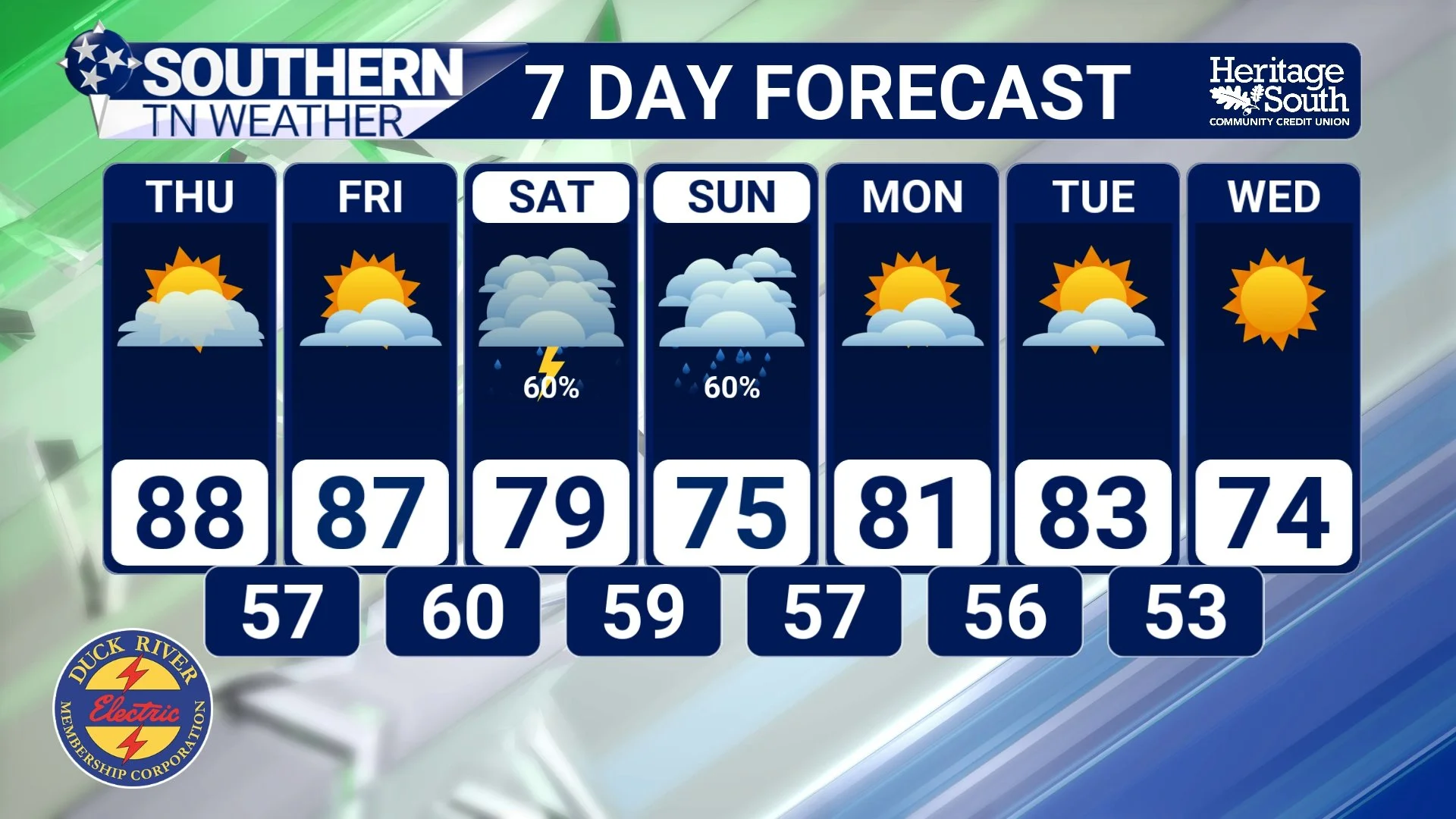
STNWX 7-DAY FORECAST
The Bottom Line 🧾
🌀 Tropical Storm Isaias continues to organize in the Gulf and is forecast to become a hurricane Thursday before strengthening significantly ahead of Gulf Coast landfall.
🌊 The northern Gulf Coast faces the much more serious threat, including hurricane-force winds, life-threatening storm surge and heavy rainfall Friday into Friday night.
🏠 Southern Middle Tennessee will experience a much weaker version of the system, but confidence is increasing that its remnants will bring a wet and windy period this weekend.
⏰ The primary impact window currently looks like Saturday afternoon through Saturday night and into early Sunday.
🌧️ Approximately 1 to 3 inches of rainfall is possible, with locally higher totals depending on the exact track and placement of heavier tropical rain bands.
💦 Much of that rainfall would be extremely beneficial for our ongoing drought, although localized flooding remains possible where heavier rain repeatedly moves across the same locations.
💨 Wind gusts of approximately 30 to 40 MPH are possible as the remnant circulation moves through Southern Middle Tennessee.
🌳 A few downed limbs, unsecured outdoor objects and isolated power outages could become possible if the stronger wind forecast verifies.
🌪️ The tornado threat currently appears LOW, but not zero. A farther-west track would generally increase that concern, while a farther-east track could keep the better tornado environment south and east.
📍 Don't focus exclusively on the exact center track. Rain, wind and thunderstorms can extend well away from the remnant circulation.
☀️ Dry and warm weather continues through Friday before conditions deteriorate this weekend.
🌤️ Conditions should gradually improve Sunday as Isaias races away, followed by another stretch of warm and dry weather early next week.
📰 Reminder: The Southern Tennessee Weather Blog, presented by Heritage South Community Credit Union, is updated Monday through Friday with fresh, locally tailored forecasts you can trust.
