
What Actually Happens When a Cold Front Passes?

The Southern Tennessee Weather Blog is proudly presented by Heritage South Community Credit Union.
We Help When Others Won’t!
Visit https://www.heritagesouth.org/ today to see how HSCCU can help YOU!
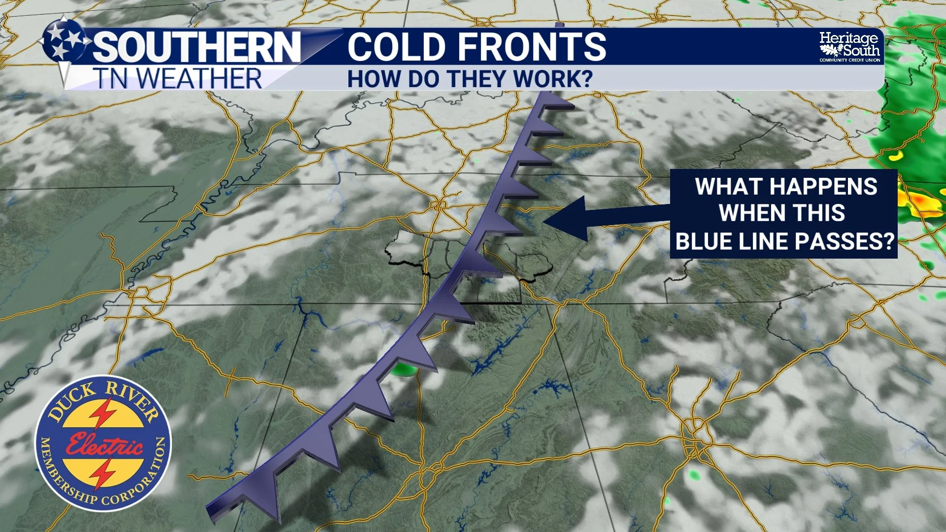
If you've looked at a weather map before, you've probably seen one: a blue line covered in little blue triangles marching across the country. That's a cold front, and considering the one moving through Southern Middle Tennessee over the next couple of days is FINALLY going to knock us out of the 90s, I imagine that blue line has quite a few fans right now…
We talk about cold fronts constantly in weather forecasts. A cold front is approaching. A cold front moves through Tuesday. Cooler and drier air arrives behind the cold front. But what does it actually mean for a front to “pass” your house? There's much more happening than a blue line sliding across a weather map. You're essentially watching one air mass replace another, and that process can change the temperature, humidity, wind direction, air pressure, cloud cover and sometimes produce thunderstorms along the way. And this week's front gives us a pretty good opportunity to watch the entire process happen in real time.
COLD FRONTS: HOW DO THEY WORK?
First Things First: What Exactly IS a Cold Front?
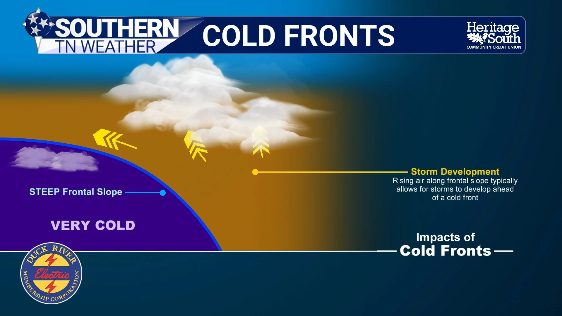
A cold front is the leading boundary of an advancing cooler air mass. On one side of that boundary, you may have warm, humid air. On the other side, the air is cooler, drier and denser. Because cooler air is generally denser than warmer air, the advancing cool air tends to wedge underneath the warmer air ahead of it. That warmer air is then forced upward. This is where cold fronts become especially important for forecasting thunderstorms. Rising air cools as it expands, and if enough moisture is present, that process can eventually lead to condensation, clouds and precipitation. If the atmosphere is also unstable enough, thunderstorms can develop.
But there's an important misconception here: a cold front does NOT automatically mean thunderstorms. A front can provide the lift, but we still need the other ingredients. Think of it somewhat like trying to start a fire. Having a match doesn't do much good without something capable of burning. Similarly, a cold front can provide a mechanism for lifting air, but if the atmosphere doesn't contain sufficient moisture and instability, very little may happen. We've had plenty of fronts move through Southern Middle Tennessee with little more than a wind shift, a few clouds and cooler air behind them. Other times, the atmosphere ahead of the front is loaded with warm, humid and unstable air. Add frontal lift, and suddenly we have numerous showers and thunderstorms.
And thunderstorms don't necessarily form directly on that pretty blue line you see on the map, either. Convergence, smaller boundaries, outflow from previous thunderstorms and other disturbances can help storms develop well ahead of the actual surface front. That's exactly why saying “the cold front arrives Tuesday” doesn't mean we have to wait until Tuesday for thunderstorms. Our atmosphere is already responding to the larger weather system today.
COLD FRONTS EXPLAINER
What Does It Feel Like When the Front Actually Passes?
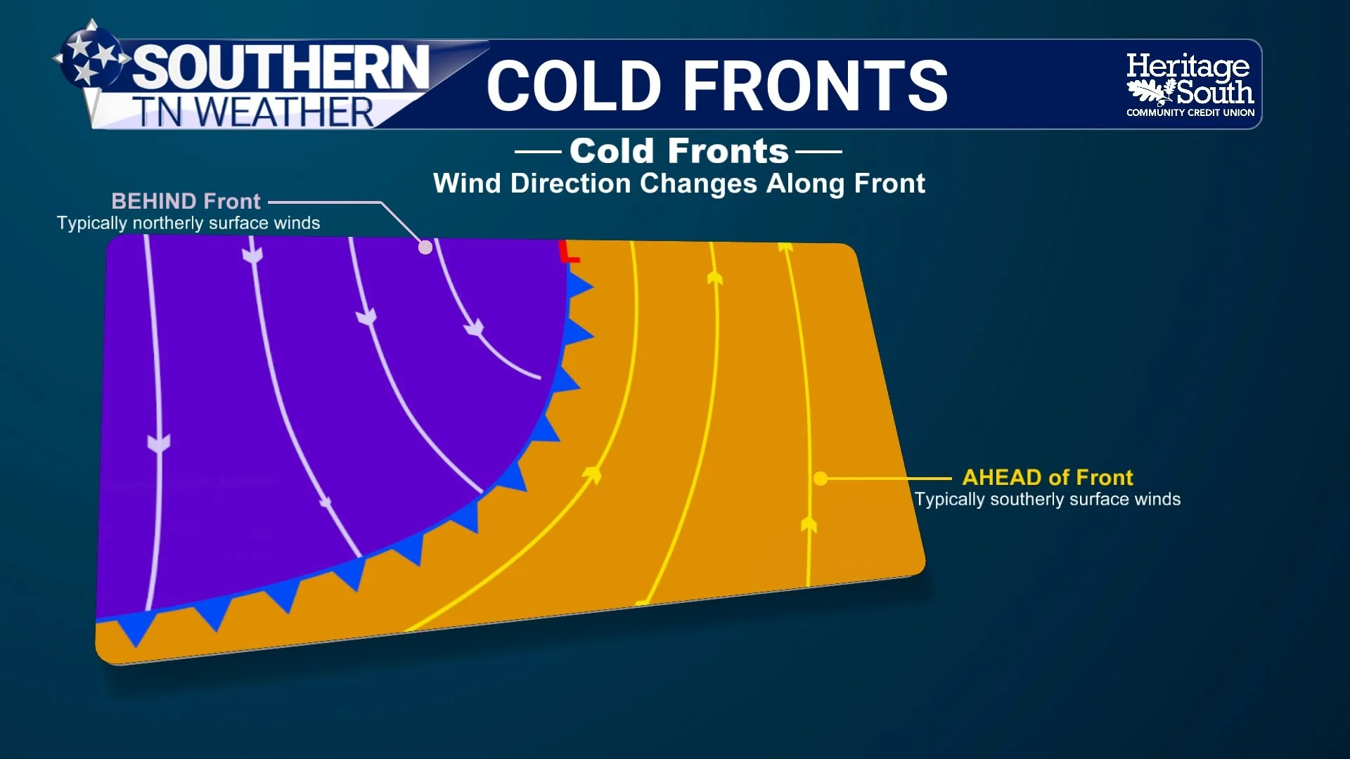
Depending on how strong the front is, you can sometimes experience the passage without ever looking at a weather map. One of the first clues is often the wind. Ahead of an approaching cold front, our winds frequently have a southerly or southwesterly component. That helps transport warmer and more humid air northward. As the boundary passes, winds typically shift and eventually develop a westerly, northwesterly or northerly component as the new air mass moves in. Meteorologists can actually use surface observations from weather stations to help determine where a front is located. If stations on one side of a boundary are reporting warm temperatures, higher dew points and southerly winds while locations just behind it suddenly have lower dew points and winds from the northwest, we've got some pretty good clues about where that boundary is sitting.
Air pressure changes as well. Pressure often falls ahead of an approaching front and then begins rising behind it as the cooler air mass moves in. Then there's the change most of us actually notice: the air starts feeling different. Interestingly, the most immediate change isn't always the temperature. A front could pass during the middle of the afternoon and temperatures might remain fairly warm for several hours. Sunshine, the time of day, cloud cover and the strength of the incoming air mass all affect how quickly temperatures respond.
The dew point, however, can sometimes fall much more noticeably. If you've been sitting in a humid air mass with dew points around 70° and much drier air arrives behind the front, you may notice the difference almost immediately. Sweat evaporates more efficiently, the air feels less sticky, and suddenly opening the windows doesn't sound like a terrible idea.
Cooler air then continues filtering into the region behind the boundary. Once the sun goes down and nighttime cooling begins, the difference between the old and new air masses can become even more obvious. So a cold frontal passage isn't necessarily 95° → FRONT PASSES → instantly 75°. It's usually more of a transition. Winds shift. Humidity falls. Pressure rises. Cooler air continues arriving. Then temperatures respond. And by the following morning, you might walk outside and realize Mother Nature has completely changed the air mass while you were sleeping.
COLD FRONTS EXPLAINER
We Get to Watch the Whole Process This Week
Our current setup is a great real-world example. A frontal boundary that has been hanging around the region for several days is finally beginning to move. Ahead of it, we still have plenty of warmth and humidity available, which means scattered showers and thunderstorms should develop this afternoon and evening as daytime heating destabilizes the atmosphere. The important word there is scattered. Thunderstorms today should be fairly hit-or-miss, so the approaching front does NOT guarantee everyone receives rain. That's particularly unfortunate considering our worsening drought conditions. One community could receive a healthy downpour while another several miles away misses out completely.
The greatest opportunity for thunderstorms today should generally come during the afternoon and evening, particularly from roughly 2 PM through 8 PM. The Storm Prediction Center has our area highlighted in a Marginal Risk, Level 1 of 5, for severe thunderstorms, with damaging winds being the primary concern. The atmosphere doesn't have much wind shear available to organize thunderstorms into long-lasting complexes, so most storms should behave more like the summertime thunderstorms we're familiar with. They'll develop, strengthen, dump a lot of rain and potentially produce a strong downburst before eventually collapsing. The atmosphere does have plenty of potential energy available for those downdrafts. A few stronger storms could produce wind gusts around 40–60 MPH, along with frequent lightning and torrential rainfall. Storm movement will also be fairly slow, around 5–10 MPH, so localized ponding or minor flooding could occur beneath the heavier downpours. A few storms could linger into tonight before gradually weakening.
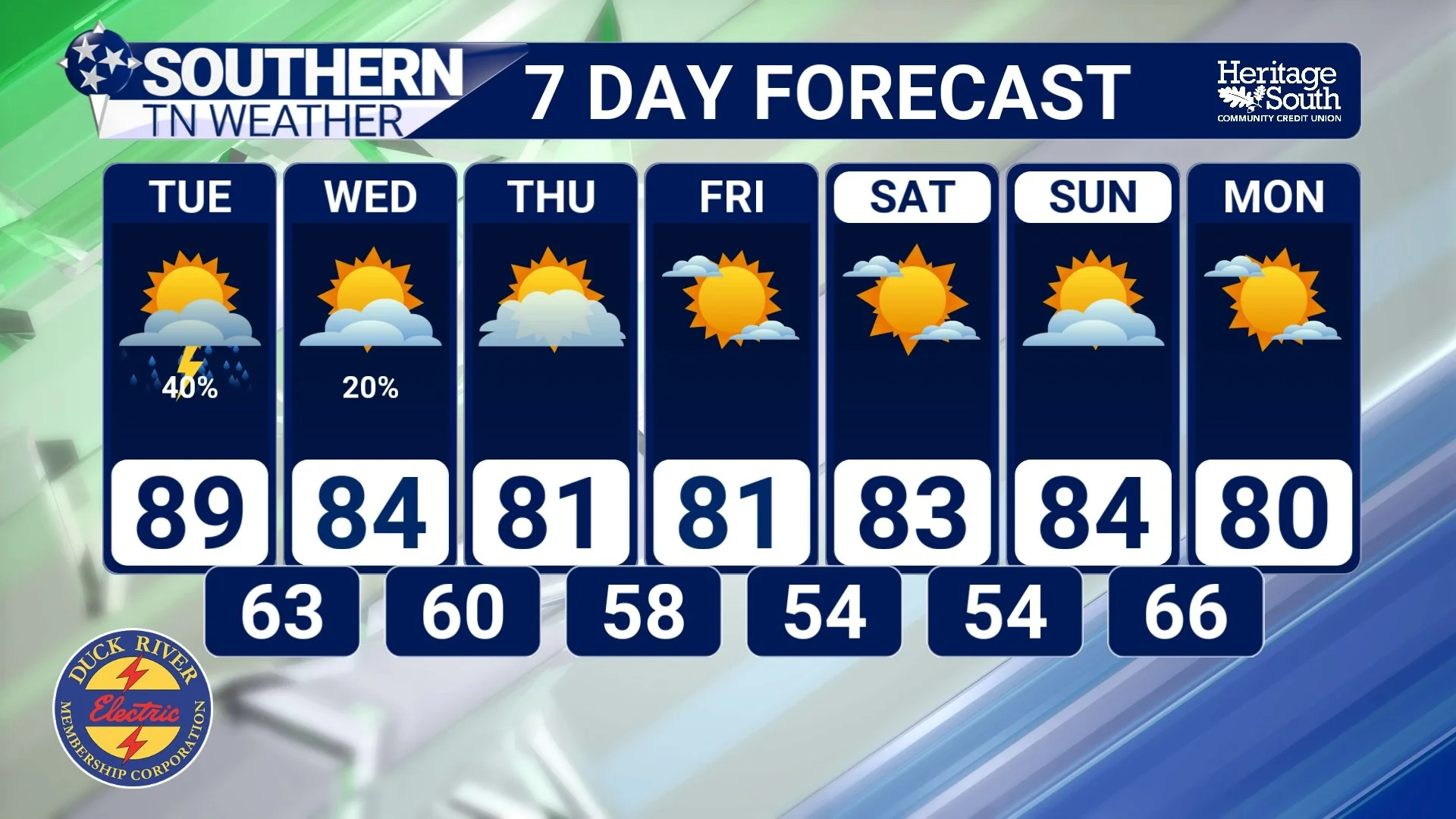
The front itself won't completely clear Southern Middle Tennessee until Tuesday, so scattered showers and thunderstorms remain possible into Tuesday as the boundary continues moving southeast. A few stronger storms with gusty winds will remain possible, although the overall severe-weather threat appears fairly low. Then comes the part I think everybody has been waiting approximately 47 years to hear... The air behind this front is ACTUALLY cooler. Tuesday will be our transition day. Clouds, showers and the advancing front should finally help keep afternoon temperatures below 90° across much of the area for the first time in several weeks.
By Wednesday, the new air mass takes over. Cooler and noticeably drier air will settle into Southern Middle Tennessee, with afternoon highs dropping into the lower to middle 80s. Dew points will fall as well, making it feel dramatically more comfortable than the oppressive heat and humidity we've endured lately. High pressure then settles across the region for the remainder of the workweek, bringing mainly dry weather and allowing nights to become increasingly cool. Highs should remain in the lower to middle 80s through much of the period, while overnight lows eventually fall into the 50s by this weekend. Dew points could even drop into the 40s.
Yes, after Heat Index values of 105–110° last week, we're now talking about morning temperatures in the 50s. What a difference one air mass can make!
STNWX 7-DAY FORECAST
The Bottom Line 🧾
🔵 A cold front is the leading boundary of an advancing cooler air mass, not a literal wall of cold air.
🌡️ Cooler, denser air tends to advance underneath warmer air and force it upward.
⛈️ That lifting can help produce thunderstorms, but a cold front doesn't automatically guarantee rain or storms. Moisture and instability still matter.
💨 As a front passes, winds typically shift, pressure begins rising, humidity decreases and cooler air gradually moves in.💧 Sometimes the drop in dew point is more noticeable immediately than the drop in temperature.
⛈️ Scattered thunderstorms are expected this afternoon and evening, with the best opportunity generally between 2–8 PM.
⚠️ A Marginal Risk, Level 1 of 5, is in place today. A few storms could produce 40–60 MPH downburst winds, frequent lightning and heavy rainfall.
🌧️ Additional scattered storms remain possible Tuesday as the front moves through.
📉 Tuesday is our transition day, with highs finally dropping below 90° across much of the area.
🍂 Wednesday brings our first true taste of fall, with highs in the lower to middle 80s and noticeably lower humidity.
🥶 Overnight temperatures could eventually fall into the 50s this weekend, with mainly dry weather expected Thursday through the weekend.
📰 Reminder: The Southern Tennessee Weather Blog, presented by Heritage South Community Credit Union, is updated Monday through Friday with fresh, locally tailored forecasts you can trust.
