
Weekend Outlook: Dangerous Heat, A Few Storms & FINALLY Signs of a Cooldown

The Southern Tennessee Weather Blog is proudly presented by Heritage South Community Credit Union.
We Help When Others Won’t!
Visit https://www.heritagesouth.org/ today to see how HSCCU can help YOU!
Well, I’m running out of creative ways to say it’s going to be dang HOT! Unfortunately, summer has absolutely no interest in leaving Southern Middle Tennessee quietly. Another scorcher is underway today, dangerous heat will continue through the weekend, and some locations could once again flirt with 100° for the actual air temperature. There are a couple of changes worth watching, though. Scattered thunderstorms become a little more possible Saturday afternoon and evening, and while widespread severe weather isn't expected, a few storms could produce strong to locally damaging wind gusts. Sunday turns somewhat quieter again, but the heat hangs on.
The MUCH more interesting part of the forecast comes next week. After what feels like approximately 14 years of summer, we're finally seeing a stronger signal for a legitimate pattern change that could knock highs out of the 90s, bring back better rain chances and potentially even send overnight temperatures into the 50s by late next week. Yes. I said 50s… But we've got to survive the weekend first.
Another Dangerously Hot Weekend
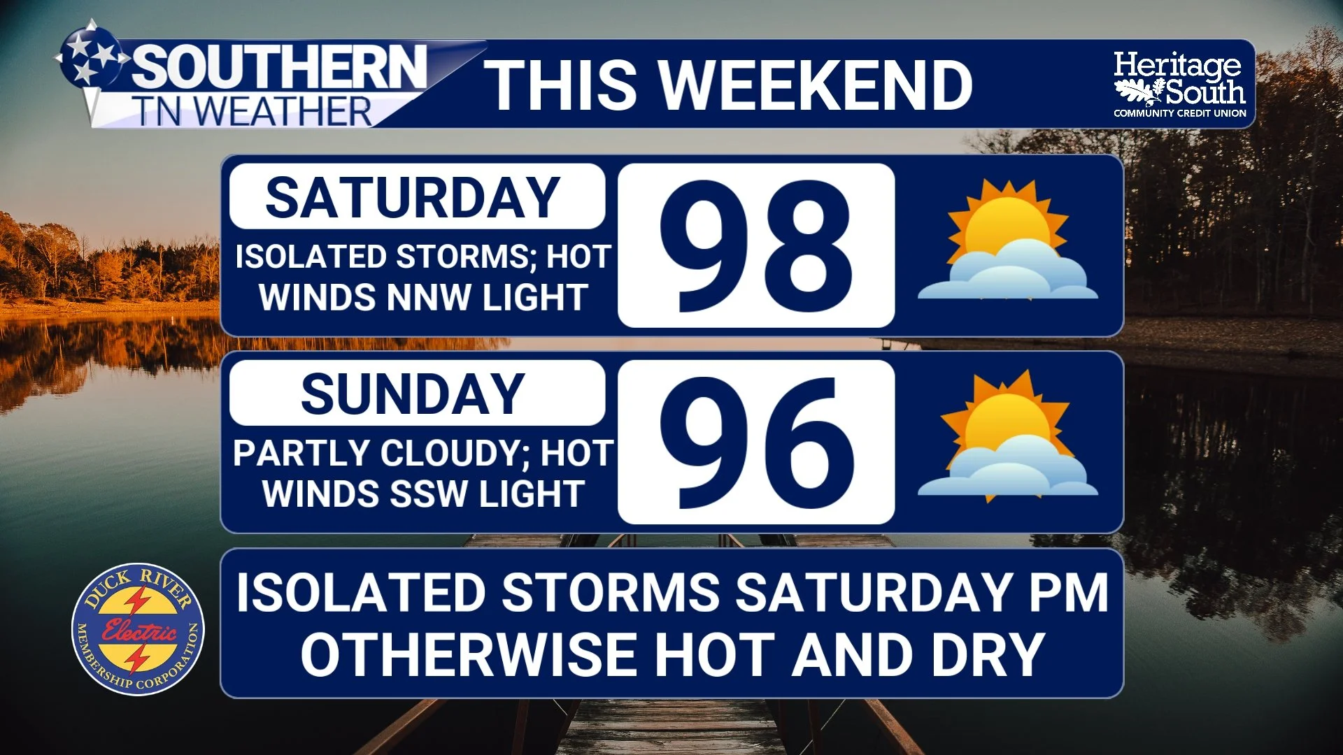
Today will be another scorcher with highs generally reaching the middle and upper 90s under mostly sunny skies. A few of our hotter locations could approach 100°, while Heat Index values climb into the 100–105° range. The ridge of high pressure responsible for this prolonged heat wave has finally started retreating toward the southwest, but it's doing so at the speed of a snail with a bad knee. Its influence will remain firmly planted across our area through the weekend and into Monday. That's going to keep temperatures way above normal. Saturday and Sunday will once again bring highs in the middle and upper 90s, with a few locations along and west of Interstate 65 potentially flirting with 100°. Overnight isn't providing much relief either, particularly across our lower elevations, where lows will generally remain in the lower and middle 70s.
A Heat Advisory remains in effect through the weekend for much of Southern Middle Tennessee, with Heat Index values potentially reaching or exceeding 105° in some locations. NWS HeatRisk also continues to indicate Moderate to Major heat impacts across the region, meaning this prolonged stretch of heat can affect anyone without adequate cooling or hydration, with greater concerns for people who are especially sensitive to heat. At this point, the heat precautions probably sound like a broken record, but they're still important. Drink plenty of water, take frequent breaks if you're working outside, find air conditioning when possible, check on elderly family members and neighbors, and never leave children or pets inside a parked vehicle. And if you're heading to a football game, festival or other outdoor event this weekend, the heat isn't the only thing you'll want to keep an eye on.
WEEKEND FORECAST
Saturday Brings Our Best Chance for a Few Storms
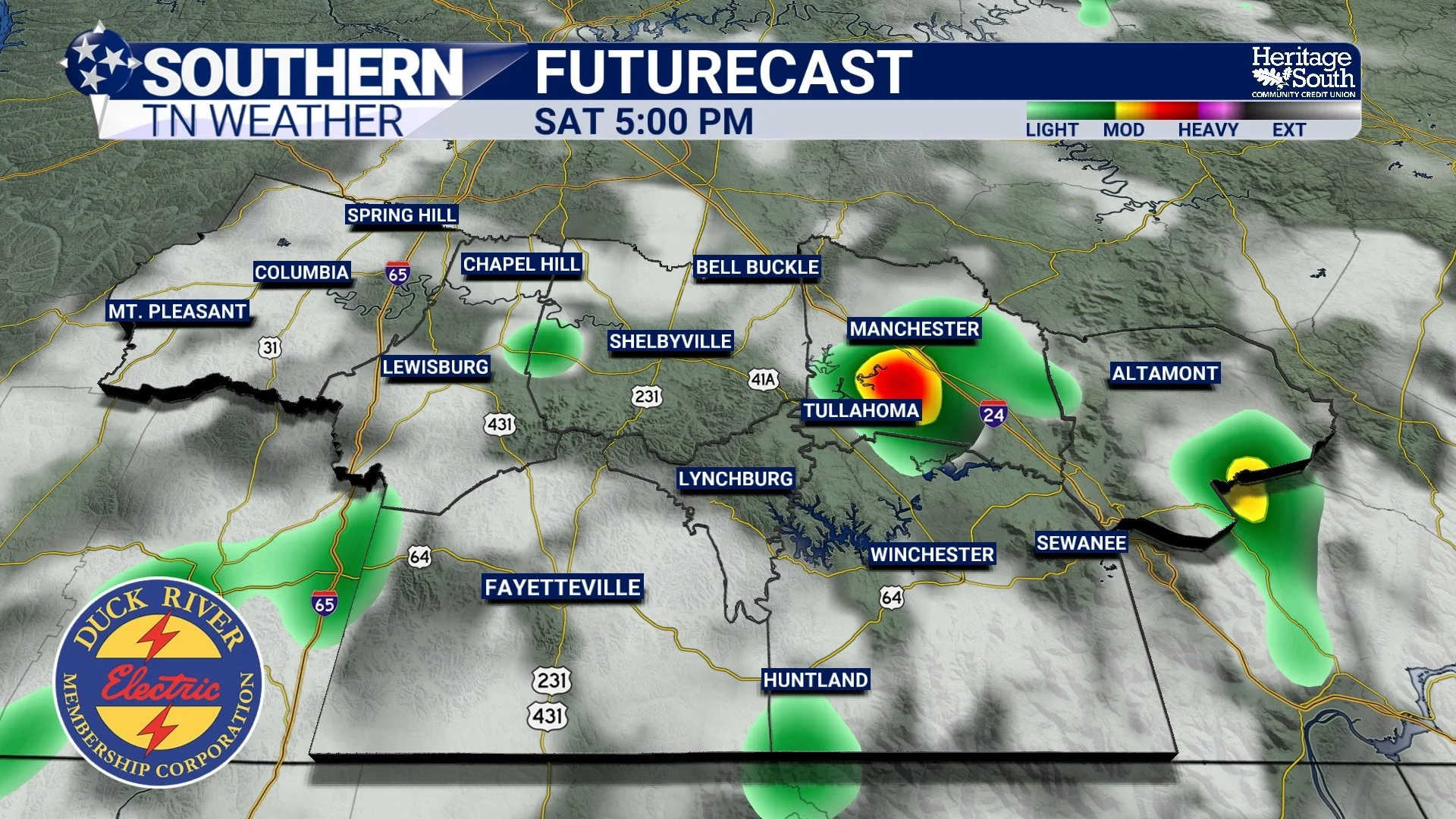
Rain chances remain extremely low today. A very isolated afternoon shower or thunderstorm could pop up, especially farther east and across the higher terrain, but the overwhelming majority of Southern Middle Tennessee will stay dry. Saturday gets a little more interesting. As the upper-level ridge gradually pulls westward, a weak disturbance will have an opportunity to move around its northeastern side. That should provide just enough help for scattered afternoon and evening thunderstorms to develop, particularly along and east of Interstate 65. This does NOT look like an all-day rain event, and many locations may once again miss out completely. But if you've got outdoor plans Saturday afternoon or evening, you'll want to keep the radar nearby.
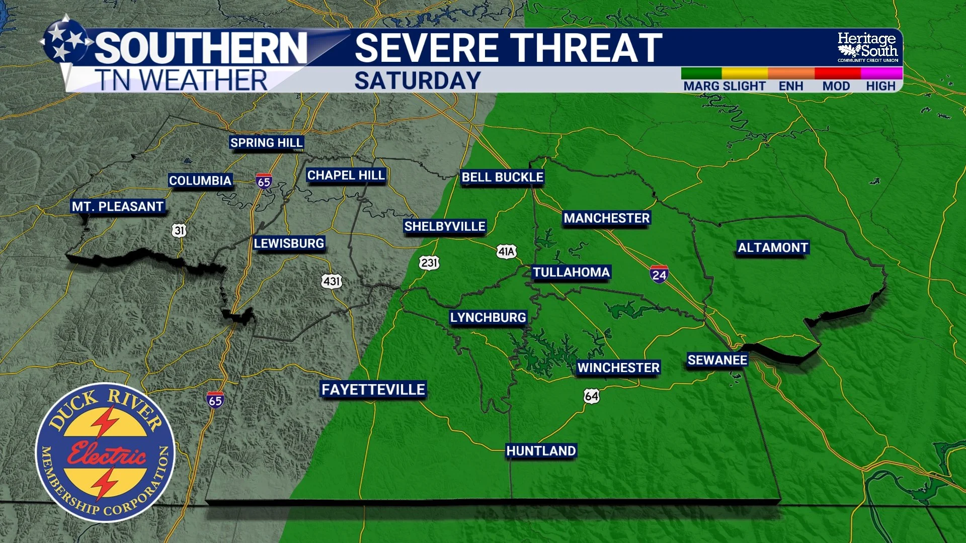
There's also a Marginal Risk, Level 1 of 5, for severe thunderstorms Saturday across eastern portions of the area, especially along and east of US 231. Widespread severe weather isn't anticipated, but the atmospheric setup could allow a few thunderstorms to produce strong to locally damaging wind gusts. The main thing we're watching is the potential for downbursts or microbursts. We've talked about these before. A thunderstorm downdraft is a rush of cooler air descending from the storm toward the ground. When that air reaches the surface, it spreads rapidly outward, sometimes producing a sudden burst of damaging straight-line wind. Saturday's atmosphere is expected to have plenty of hot, relatively dry air beneath the thunderstorms. As rain falls through that drier layer, some of it evaporates. Evaporation cools the surrounding air, making it denser and helping accelerate the downdraft toward the ground.
We use a measurement called DCAPE, or Downdraft Convective Available Potential Energy, to help estimate the potential strength of those descending air currents. Values Saturday could exceed 1,000 J/kg, which supports the possibility of some pretty punchy downbursts beneath the strongest storms. That doesn't mean every thunderstorm will produce damaging wind. Far from it. Storm coverage will remain scattered, and the overall severe threat is low. But one isolated storm can still produce a 50–60+ MPH wind gust, frequent lightning and a quick torrential downpour. So don't ignore a storm simply because there isn't a widespread severe-weather setup underway.
By Sunday, atmospheric moisture decreases slightly and rain chances should fall again. An isolated afternoon storm remains possible, particularly east of Interstate 65, but most locations should stay dry. Unfortunately, temperatures will once again climb well into the 90s with Heat Index values around 100–105°. And that's where our attention starts turning toward what happens next…
SATURDAY SEVERE RISK
FUTURECAST SATURDAY EVENING
Wait... Are Those 50s I See Next Week?!
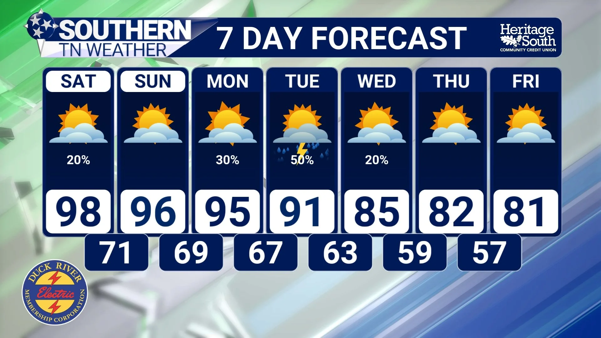
I've been advertising a gradual cooldown for several days now, but the signal for a more noticeable pattern change is becoming increasingly interesting. The ridge responsible for our heat should continue retreating westward while the overall upper-level pattern begins changing across the eastern United States. By Monday and especially Tuesday, a trough and approaching cold front should help bring moisture back into the region and increase our opportunities for showers and thunderstorms. Rain chances become more widespread early to midweek, generally reaching the 30–50% range. Considering yesterday's Drought Monitor showed worsening drought conditions across Southern Middle Tennessee, including Severe Drought entering portions of Bedford County, we'll gladly take any opportunity for widespread beneficial rainfall.
There may also be enough instability early in the week for a few stronger thunderstorms, so we'll have to watch Monday and Tuesday as the details become clearer. At this point, confidence isn't high enough to advertise a widespread severe-weather problem, but gusty storms could become possible as the front approaches. The bigger story for most people, however, will probably be the thermometer. Temperatures should finally start backing away from the upper 90s as we move through the middle of next week. There are still some differences in exactly how quickly the cooler air arrives and just how cool we ultimately get, but the overall trend is becoming increasingly encouraging.
Current guidance has highs falling into the 80s by Wednesday and Thursday, and some of the latest blended guidance is even suggesting upper 70s to lower 80s by the end of next week. And then there's the number I almost forgot existed... 50s! If the cooler and drier air mass arrives as currently advertised, overnight lows could eventually fall into the upper 50s to lower 60s late next week.
Now, before everybody starts dragging the hoodies out of storage, we're still several days away. Exactly how the upper-level pattern evolves will determine how much cooler air actually reaches Southern Middle Tennessee, and there's plenty of time for those numbers to change. But unlike some of the tiny “cooldowns” we've watched disappear on the weather maps this summer, there's a growing signal for a genuine pattern change.
Knock on wood... we're getting there.
STNWX 7-DAY FORECAST
The Bottom Line 🧾
🥵 Dangerous heat continues through the weekend, with highs in the middle and upper 90s and a few locations potentially approaching 100°.
🌡️ Heat Index values could reach 100–105°+, and a Heat Advisory remains in effect through the weekend for much of Southern Middle Tennessee.
🌦️ A very isolated shower or storm is possible today, but most locations remain dry.
⛈️ Saturday brings our best weekend storm chance, especially along and east of Interstate 65.
💨 A few Saturday storms could produce strong to locally damaging downburst winds. A Marginal Risk, Level 1 of 5, is in place for eastern portions of the area.
☀️ Sunday trends somewhat drier again, but the heat continues.
🌧️ More widespread rain and thunderstorm chances return Monday through the middle of next week.
🌵 Any widespread rainfall would be welcome following our recent drought deterioration.
📉 A more noticeable cooldown should develop by the middle and latter portions of next week.
🍂 Highs could eventually fall into the upper 70s and 80s, with overnight lows potentially reaching the upper 50s to lower 60s if current trends hold.
📰 Reminder: The Southern Tennessee Weather Blog, presented by Heritage South Community Credit Union, is updated Monday through Friday with fresh, locally tailored forecasts you can trust.
