
The Storms Have Moved South... And The Atmosphere Is Finally Settling Down

The Southern Tennessee Weather Blog is proudly presented by Heritage South Community Credit Union.
We Help When Others Won’t!
Visit https://www.heritagesouth.org/ today to see how HSCCU can help YOU!
A Busy Morning Marks The End Of An Active Stretch
If you spent part of your morning watching radar, you're probably not alone. A line of thunderstorms pushed through Southern Middle Tennessee during the late morning hours, bringing pockets of heavy rain, gusty winds, and plenty of lightning before sliding south into northern Alabama. While a few isolated storms may still try to redevelop this afternoon, especially west of Interstate 65, the overall trend is becoming increasingly clear.
The weather pattern that has kept us talking about thunderstorms almost every day for the past two weeks is finally beginning to loosen its grip on Tennessee. For meteorologists, some forecasts are difficult because of what might happen. This week's forecast is unusual because of what probably won't happen.
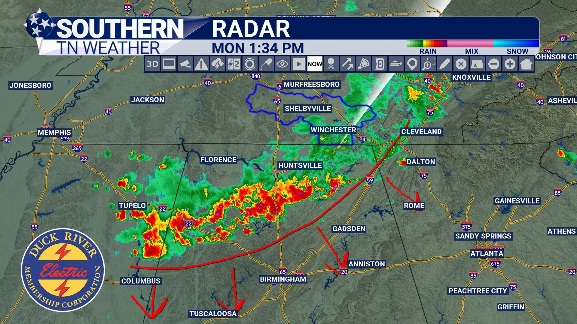
RADAR - RIGHT NOW
The Radar Is About To Get Boring
Over the past couple of weeks, checking radar became part of the daily routine across Southern Middle Tennessee. Nearly every afternoon featured at least some chance of showers or thunderstorms, and many days brought multiple rounds of rainfall. That won't be the case this week…
Beginning Tuesday, a large area of high pressure will begin expanding across the Tennessee Valley. High pressure is often described as "sinking air," and that's important because sinking air makes it much harder for clouds and thunderstorms to develop. Instead of watching storms bubble up each afternoon, we'll likely spend much of the week watching blue skies take over. Honestly, the most interesting thing about this week's forecast may be how uneventful it becomes.
Sunshine Becomes The Main Weather Story
It's easy to focus on storms because they're exciting. They show up on radar, trigger alerts, and create dramatic pictures. But some of the nicest weather days of the year are often the quiet ones.
Tuesday through Friday looks remarkably pleasant by early June standards. Afternoon temperatures will generally stay in the upper 70s and lower 80s before gradually warming later in the week. Overnight lows will fall into the 50s and lower 60s, allowing for cool mornings and comfortable evenings. After the unsettled pattern we've experienced recently, those numbers are about as close to perfect as Tennessee weather gets.
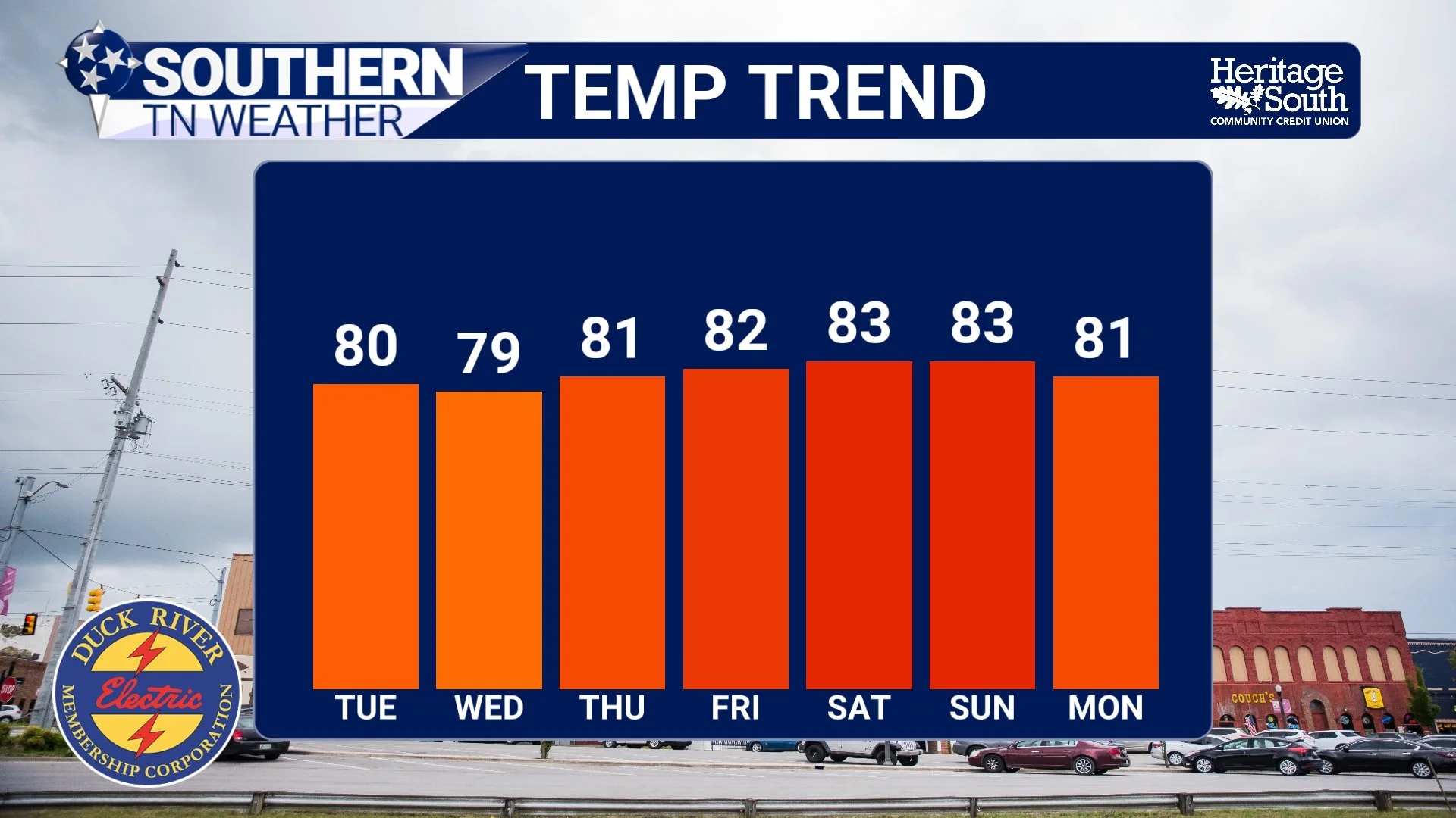
TEMPERATURE TREND - NEXT 7 DAYS
Summer Isn't Finished Yet… Well, it’s actually just starting
Of course, this is only a pause button, not an ending. Forecast guidance already suggests moisture will slowly begin returning next weekend as the ridge weakens and shifts eastward. That doesn't necessarily mean a return to the daily storm pattern we just escaped, but it does mean rain chances will gradually work their way back into the forecast. For now, though, Southern Middle Tennessee gets something it hasn't had much of lately: Several consecutive days where the weather simply isn't the biggest story.
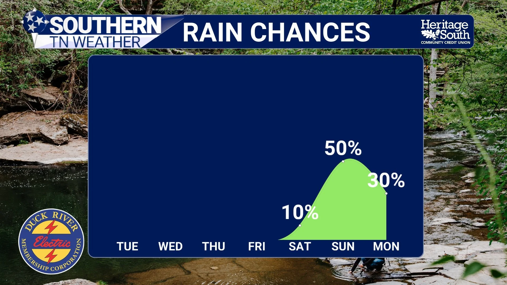
RAIN CHANCES - NEXT 7 DAYS
The Bottom Line 🧾
This morning's storms have pushed south into northern Alabama.
A few isolated storms remain possible this afternoon.
Dry weather returns Tuesday and continues through at least Friday.
Sunshine will dominate much of the week.
Temperatures will remain near seasonal norms.
Rain chances gradually return next weekend.
📰 Reminder: The Southern Tennessee Weather Blog, presented by Heritage South Community Credit Union, is updated Monday through Friday with fresh, locally tailored forecasts you can trust.