
A Wet Monday Night and Tuesday Ahead…
Quiet so far today…
It’s been dry, breezy, and unseasonably warm across Southern Tennessee this Monday, with highs near 70 degrees. This is well above the average for late November. While we aren’t in record territory today, the warmth won’t last long, as our next widespread rainmaker is already approaching from the west.
Today’s blog will focus entirely on the next 48 hours. If you’re looking for a detailed Thanksgiving forecast (which are looking fantastic, by the way), hang tight — I’ll have that in tomorrow’s blog. Clouds will continue to increase through the afternoon, and I expect light showers to begin overspreading the region near and after sunset. Here’s a look at radar as of the time of this post, showing activity not far to our west in Western Tennessee.
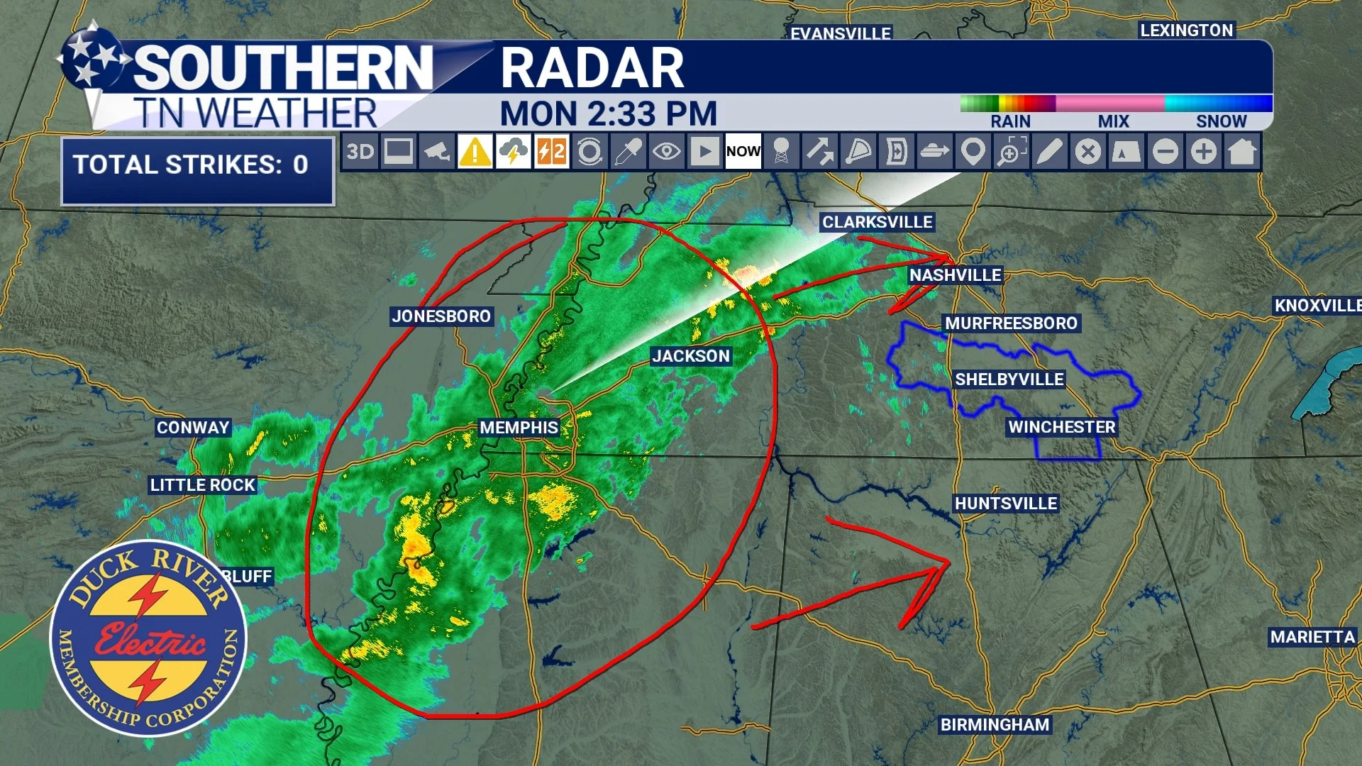
STNWX - Radar Right Now
Showers and Storms Late Tonight Into Tuesday
Rain and a few rumbles of thunder will move in overnight as a cold front approaches. The most widespread and steady rainfall will occur between midnight and 5 AM, with periods of moderate to heavy rainfall likely.
Even though wind energy aloft will be quite strong, instability will be very limited — meaning the risk for severe weather tonight and Tuesday morning is very low. This should be more of a “good sleeping weather” type setup rather than anything concerning. There is the chance for a few more showers and storms on Thursday afternoon, which can be found by scrolling below!
Strong Winds Without Thunderstorms
It’s worth noting that the National Weather Service highlights a low to medium chance of non-thunderstorm wind gusts of 30–40 mph overnight into Tuesday morning. So if you have lightweight Christmas decorations outside… maybe make sure Santa, the Grinch, and Cousin Eddie’s RV don’t take flight.
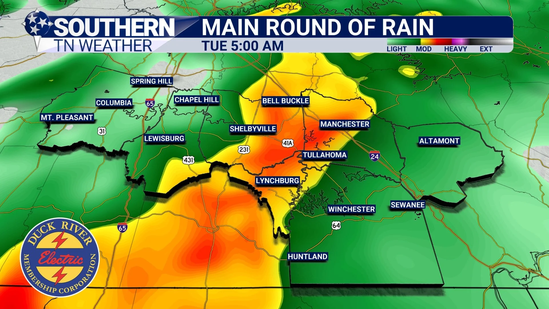
Main Round of Stormage… Early tomorrow morning
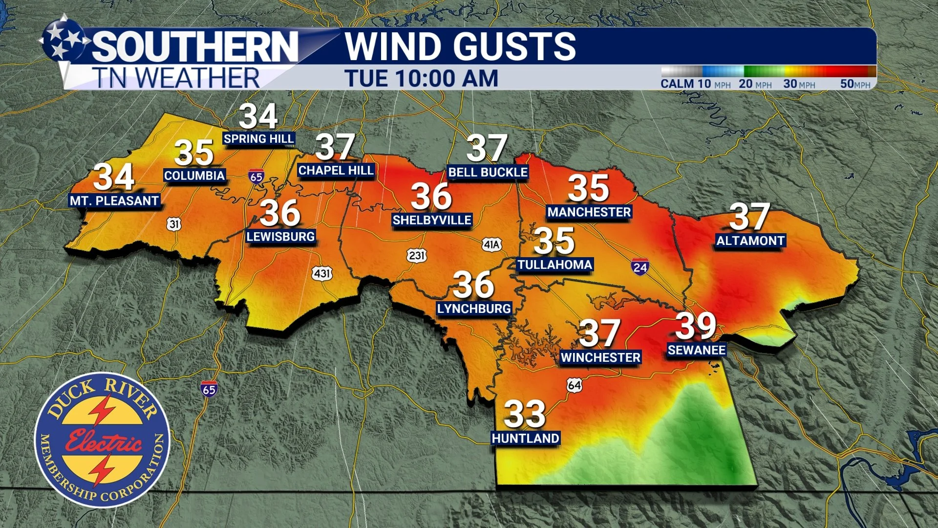
HRRR Futurecast Wind Gusts
A Secondary Round of Storms…?
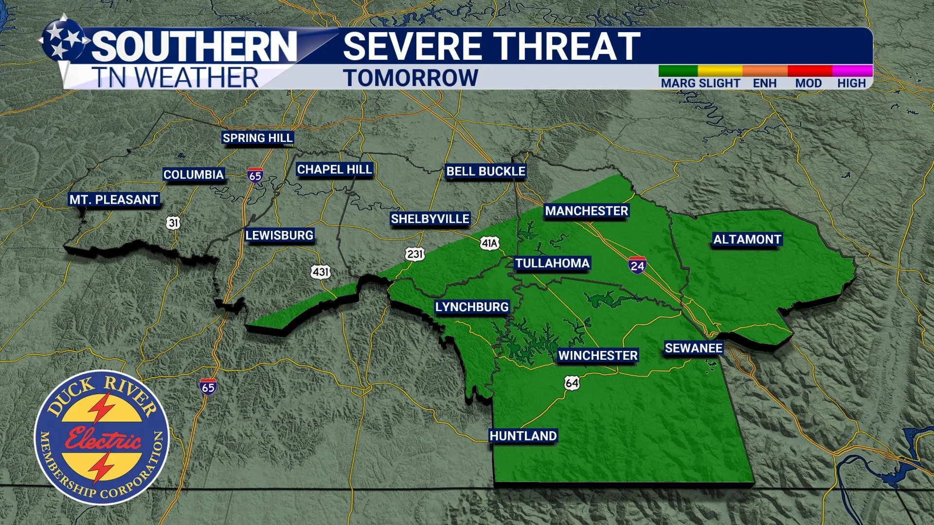
There is some uncertainty surrounding a second window for storms Tuesday afternoon and early evening, mainly between noon and 6 PM. This activity would form along the cold front as it pushes eastward, with the highest chance of development along and east of I-65, including Bedford, Coffee, Moore, Franklin, and Grundy Counties.
Even if storms do form, there are still question marks about how strong they may become. The strongest wind energy will be departing by then, but there may be just enough storm fuel to support a few stronger pockets. Whether this happens depends heavily on how much the atmosphere can recover from the morning rainfall. If clouds remain thick and temperatures fail to warm, the environment will not support strong storms. If we get more breaks in the clouds than expected, a stronger storm or two becomes slightly more possible. At this time, the threat remains low, and any stronger storms would mainly produce gusty winds or small hail. The tornado threat is very low — roughly a 2% probability within a 25-mile radius.
This is not a situation to worry about, but rather one to simply stay aware of.
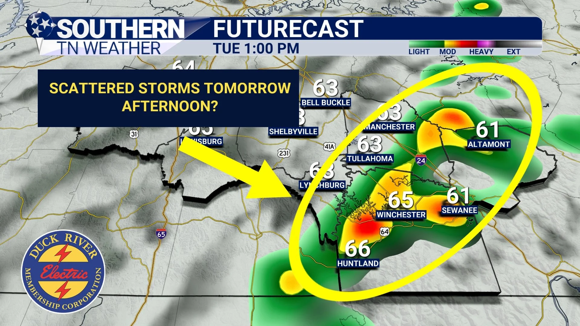
HRRR Futurecast - 1:00 PM Tuesday
Storm Prediction Center - Severe Weather Outlook for Tuesday
Overall Timing
To summarize clearly: The first round of widespread rain and storms arrives between midnight and 5 AM and will bring a wet start to Tuesday. A second round of scattered storms may attempt to form Tuesday afternoon, mainly east of I-65, but the potential for these storms to become strong depends entirely on how much the atmosphere can destabilize. Right now, there is little indication that strong destabilization will occur, but the possibility cannot be fully removed from the forecast.
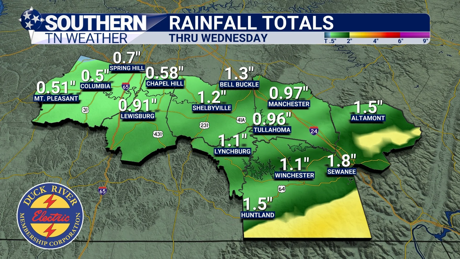
Rain Totals
Rainfall projections have ticked downward slightly, but a general half inch to two inches of rain is expected through Tuesday night. The highest totals will likely be across Franklin and Grundy Counties and nearby higher terrain, while other areas may finish on the lower end of the range.
Futurecast Rainfall Totals - Thru Wednesday
Wednesday Through Thanksgiving
Once Tuesday’s front moves through, the weather pattern shifts quickly. Much cooler and drier air settles in Wednesday through Friday, and widespread freezing temperatures are expected both Wednesday and Thursday nights. Thanksgiving is on track to be a beautiful day with sunshine and highs in the upper 40s / low 50s — crisp, comfortable, and finally feeling like late fall. After the roller coaster of warmth and cold we’ve experienced this month, it actually feels fitting that Thanksgiving will feel like Thanksgiving.
The Bottom Line 🧾
• Widespread rain and a few thunderstorms move in between midnight and 5 AM tonight
• A very low-end chance for a few stronger storms Tuesday afternoon, mainly east of I-65
• Non-thunderstorm wind gusts of 30–40 mph possible overnight into Tuesday morning
• Rain totals through Tuesday night will range from 0.5” to 2”, with the highest amounts in Franklin and Grundy Counties
• Much cooler and drier weather arrives Wednesday through Friday
• Widespread freezing temperatures expected Wednesday and Thursday nights
• Thanksgiving looks beautiful, sunny, and seasonably cool with highs in the upper 40s / low 50s
📰 Reminder: Our Southern Tennessee Weather Blog is updated Monday through Friday with fresh, locally tailored forecasts you can trust.
Be sure to follow along so you never miss an update!
You can track the incoming activity on the STN Weather App, the interactive radar at stnweather.com/radar, and the 24/7 STN Weather Channel on YouTube.