
Drought Monitor Update: Dry Conditions Expanding

The Southern Tennessee Weather Blog is proudly presented by Heritage South Community Credit Union.
We Help When Others Won’t!
Visit https://www.heritagesouth.org/ today to see how HSCCU can help YOU!
Yesterday, we talked about what makes a truly beneficial soaking rain and why not all rainfall is created equal. Today, we have a brand-new update from the U.S. Drought Monitor, and unfortunately, our recent stretch of hot and mostly dry weather is beginning to show up more clearly across Southern Middle Tennessee. That may seem a little strange considering how wet much of this summer has been. We certainly haven't spent the entire season begging for rain. In fact, there have been plenty of times this summer when we probably would've preferred Mother Nature turn the faucet OFF for a little while.
But drought conditions can change surprisingly quickly, especially during periods of persistent heat. Over the past several weeks, widespread rainfall opportunities have become much less frequent while temperatures have remained well above normal. According to this week's U.S. Drought Monitor discussion, short-term rainfall deficits are growing across much of the South while soil moisture and streamflow levels have been dropping. Portions of Tennessee were among the areas where conditions deteriorated this week. The good news is that our wetter weather earlier this summer still matters. The U.S. Drought Monitor specifically notes that Tennessee's rapid drying followed a much wetter period, which has helped lessen some of the impacts of the recent heat and lack of rainfall. In other words, we had some money in the moisture savings account before this dry stretch began. Unfortunately, we've been making quite a few withdrawals lately.
What Does the New Drought Monitor Show?
Looking at the newest map, Abnormally Dry conditions, or D0, now cover a large portion of Southern Middle Tennessee, including much of Maury, Marshall, Lincoln and surrounding areas. Meanwhile, a pocket of Moderate Drought, or D1, has developed across portions of Bedford County and extends into nearby areas. It's important to understand the distinction between those two classifications.
D0, or Abnormally Dry, is NOT technically drought. Think of D0 as something of a warning sign. Conditions are becoming unusually dry, short-term rainfall deficits may be increasing, soil moisture may be declining, and vegetation can begin showing signs of stress. D0 can appear as an area is heading toward drought, but it can also appear when an area is recovering from drought and hasn't completely returned to normal.
D1, or Moderate Drought, is the first actual drought category. At this level, impacts can become more noticeable. Pastures and crops may begin experiencing stress, soil moisture deficits become more meaningful, streamflow and smaller water sources can begin declining, and agricultural operations may increasingly feel the effects of insufficient rainfall. Beyond that are D2, Severe Drought; D3, Extreme Drought; and D4, Exceptional Drought. Thankfully, we're nowhere near those classifications across Southern Middle Tennessee right now.
As drought severity increases, so do the potential impacts. D2 can bring more significant crop and pasture losses, worsening water shortages and substantially reduced streamflow. D3 represents a much more serious drought where major agricultural losses and widespread water-supply concerns can develop. D4 is the highest classification and represents exceptional, potentially long-lasting drought with widespread and severe agricultural, ecological and water-supply impacts.
So when you see yellow and tan beginning to appear on our local map, it doesn't mean we're suddenly experiencing some historic drought. But it does tell us the recent drying trend has become significant enough to start showing up in multiple drought indicators. And that's something worth watching.
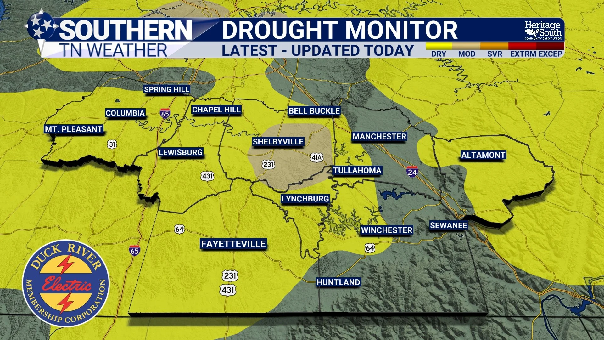
DROUGHT MONITOR - LATEST
How Does the Drought Monitor Decide Where Drought Exists?
This is probably the most important part of today's blog because the U.S. Drought Monitor is not simply a rainfall map. The map is produced each week using a combination of numerous datasets and observations. Analysts consider recent precipitation, longer-term rainfall deficits, soil moisture, streamflow, vegetation health, groundwater information, temperature and several drought indices. They also incorporate reports from people and agencies on the ground.
That's why receiving a thunderstorm doesn't necessarily mean your drought category disappears the following Thursday. Meteorologists, climatologists and other experts are looking at the overall moisture picture, not simply asking, “Did it rain this week?” For example, an area could receive an inch of rain but still have below-normal soil moisture and streamflow after several weeks of hot, dry weather. Another location could have received less recent rainfall but still be in relatively good shape because it entered the dry period with wetter soils and healthier water supplies.
This is also where local reports become valuable. Agricultural extension offices, farmers, water managers, National Weather Service offices and other observers can report things such as stressed crops, declining pasture conditions, low ponds, reduced streamflow or unusually dry soils. Those real-world observations help analysts determine whether the numbers showing up in drought indices are translating into actual impacts. That brings us to another little piece of information you may notice when looking at the Drought Monitor website.
What Does the “SL” Beside Our Drought Classification Mean?
If you pull up the detailed U.S. Drought Monitor information, you may notice “SL” listed alongside the drought designation in our area. Those letters describe the type, or timescale, of drought conditions being observed. “S” means short-term impacts, generally associated with conditions developing over a period of less than six months. These can include agricultural impacts, declining soil moisture and other relatively quick responses to a lack of rainfall.
“L” means long-term impacts, generally associated with conditions developing over periods longer than six months. Those can include effects on groundwater, reservoirs and other water resources that respond more slowly to precipitation changes.
When “SL” appears together, it means drought impacts are being identified across both short- and long-term timescales. That context matters because drought isn't simply determined by whether your grass looks brown this afternoon. Different parts of the environment respond to dry weather at very different speeds. Your lawn can become stressed relatively quickly, while a large reservoir or deeper groundwater system may take considerably longer to respond. In our particular situation, the Drought Monitor's South region discussion emphasizes the rapid short-term drying taking place across Tennessee and surrounding areas. Hot temperatures combined with increasingly sparse rainfall have allowed rainfall deficits to grow while soil moisture and streamflow have fallen. At the same time, the wetter conditions we experienced earlier have helped prevent the impacts from becoming considerably worse.
And Now We Have Some Rain Coming
Here's where today's drought update gets a little more encouraging. We've got several opportunities for rainfall over the next couple of days, and Saturday currently looks like our best opportunity for widespread rain in quite some time.
For the remainder of Thursday, Southern Middle Tennessee remains hot and humid. Highs will generally reach the lower 90s, with upper 80s across the Cumberland Plateau. Heat Index values may climb above 100° in some areas. Scattered thunderstorms will become possible this afternoon and evening, particularly farther north across Middle Tennessee. A few stronger storms could produce gusty winds and very heavy downpours, with the greatest opportunity generally between the afternoon and early evening.
Rain chances begin increasing more noticeably Friday as a weak front settles into Middle Tennessee and another disturbance approaches Southern Middle Tennessee. On Saturday, we’re highlighting a considerably wetter setup. Rain and thunderstorm coverage should become much more widespread, with the Huntsville office currently indicating 70–90% rain chances across the Tennessee Valley. Increased clouds and rainfall should also knock temperatures back somewhat, with many locations holding in the middle 80s to around 90°.
There is one catch, and it ties directly back into yesterday's blog. Atmospheric moisture will be very high and winds responsible for moving thunderstorms along won't be particularly strong. That means some storms could move slowly and dump a tremendous amount of rain over a relatively short period. The Weather Prediction Center has highlighted portions of the region for a Marginal Risk of Excessive Rainfall Friday and Saturday, meaning localized flooding could become an issue beneath the heaviest storms.
So yes, we need rain. But we'd much rather receive an inch or two spread over many hours than have Mother Nature attempt to dump the whole thing on us in 30 minutes. The severe-weather threat currently appears low. There should be enough instability for an isolated strong storm with gusty winds, but the ingredients necessary for a more organized severe-weather event don't look particularly impressive. Heavy rainfall and localized flooding are arguably the bigger things to watch through Saturday.
Unfortunately, the wetter pattern doesn't appear likely to stick around for very long. Rain chances decrease after Saturday, with only isolated to scattered afternoon showers and thunderstorms expected through much of next week. High pressure is forecast to strengthen again, potentially pushing temperatures back into the middle 90s Tuesday and Wednesday. There are at least some early indications of cooler weather trying to arrive by next weekend, but there's still plenty of uncertainty that far out. For now, we'll gladly take whatever beneficial rainfall we can get over the next few days!
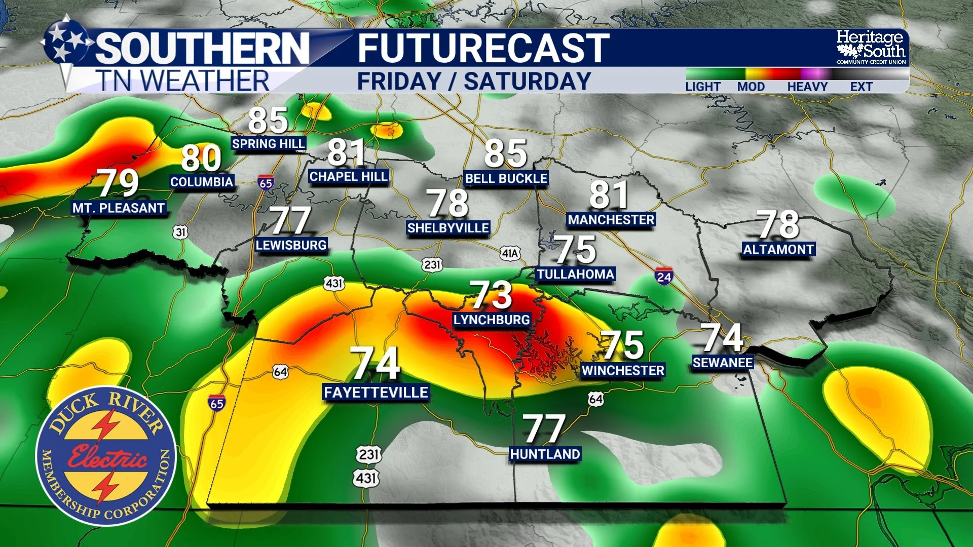
FUTURECAST - FRIDAY / SATURDAY
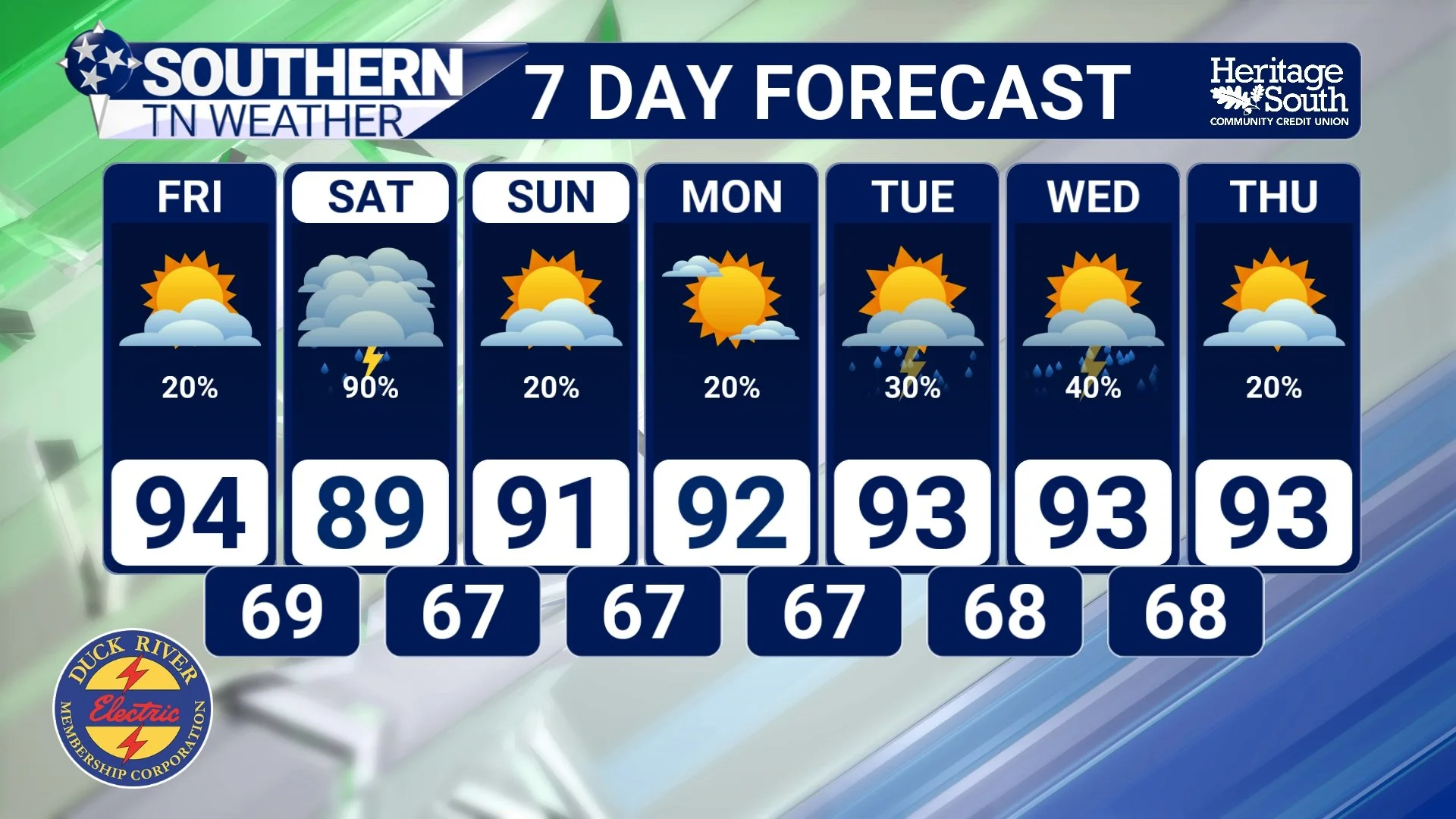
STNWX 7-DAY FORECAST
The Bottom Line 🧾
🌵 Drought conditions have expanded across portions of Tennessee this week following several weeks of hot and increasingly dry weather.
🟡 D0, or Abnormally Dry, is not technically drought. It's often an early indication that unusually dry conditions are developing.
🟤 D1, or Moderate Drought, is the first official drought category, and portions of our area have now reached that level.
📊 The Drought Monitor doesn't rely solely on rainfall totals. Soil moisture, streamflow, vegetation, groundwater, temperatures, drought indices and reports of actual impacts are also considered.
🔤 “S” represents short-term drought impacts, “L” represents long-term impacts, and “SL” indicates both timescales are involved.
🌧️ Rain chances increase Friday, with Saturday currently looking like our best opportunity for widespread rainfall.
💧 Slow-moving storms and very high atmospheric moisture could produce locally heavy rainfall Friday and Saturday.
⚠️ Localized flooding is possible beneath the heaviest storms, even though we're experiencing increasingly dry conditions.
⛈️ The organized severe-weather threat currently appears low, although isolated strong storms with gusty winds are possible.
🔥 Rain chances decrease again after Saturday, with hot and humid conditions likely continuing into next week.
📰 Reminder: The Southern Tennessee Weather Blog, presented by Heritage South Community Credit Union, is updated Monday through Friday with fresh, locally tailored forecasts you can trust.
