
Weekend Outlook: Isaias Brings a Wet, Windy Saturday to S Middle TN

The Southern Tennessee Weather Blog is proudly presented by Heritage South Community Credit Union.
We Help When Others Won’t!
Visit https://www.heritagesouth.org/ today to see how HSCCU can help YOU!
Well, folks, we've made it to Friday, and after spending much of the week watching Hurricane Isaias develop and strengthen in the Gulf, we're finally approaching the point where its impacts will begin reaching Southern Middle Tennessee. Unfortunately, if you've got outdoor plans this weekend, especially on Saturday, Mother Nature isn't exactly cooperating. We're expecting widespread tropical rainfall, strong wind gusts and the possibility of a few brief tornadoes as the remnants of Isaias move northward through our region.
The good news is that we're not expecting hurricane conditions here at home, and the worst of the weather should be relatively short-lived as Isaias moves quickly inland. However, that doesn't mean Saturday is going to be an ordinary rainy day. Wind gusts exceeding 40 MPH will be possible across much of Southern Middle Tennessee, with some locations potentially experiencing stronger gusts. Rainfall totals of 1 to 3 inches are expected across much of the area, and locally higher amounts could lead to flooding concerns. A Wind Advisory is in effect for all of Middle Tennessee, while a Flood Watch covers portions of the region.
Meanwhile, Isaias has strengthened into a major hurricane over the Gulf. As of the National Hurricane Center's 10 AM advisory, maximum sustained winds had reached 120 MPH, making it a Category 3 hurricane. The storm is expected to approach the northern Gulf Coast later this evening, with landfall increasingly favored near the extreme western Florida Panhandle. Life-threatening storm surge, destructive winds and significant flooding are expected along portions of the coast, while the system's wind and rain impacts will extend well inland through Alabama and eventually into Tennessee. For us, the biggest takeaway is that Saturday is looking increasingly likely to be a washout, with strong winds adding another layer of concern. Here's how everything is expected to unfold.
Friday: One Last Quiet Day Before Conditions Deteriorate
We'll close out the work week with relatively quiet weather across Southern Middle Tennessee, although there will be some noticeable changes as Isaias approaches the Gulf Coast. Clouds will gradually increase throughout the afternoon, but most locations should remain dry with temperatures climbing into the lower and middle 80s. Winds will also begin increasing as the pressure gradient tightens between the approaching hurricane and surrounding areas of high pressure.
For those heading to high school football games Friday evening, the forecast still looks relatively favorable compared to what we'll experience Saturday. Increasing clouds and a strengthening breeze will be the main features through much of the evening, with most locations expected to remain dry during the games. However, conditions will begin deteriorating overnight as the outer rain bands associated with Isaias spread northward into Alabama and Tennessee.
The latest forecast guidance suggests rainfall will begin overspreading Southern Middle Tennessee sometime between midnight and 6 AM Saturday, generally advancing from south to north. Winds will also become increasingly gusty overnight, particularly as the remnant circulation begins accelerating inland. By sunrise Saturday, many locations could already be dealing with periods of steady rain and noticeably stronger winds. If you've got anything outside that could blow around, including Halloween decorations, patio furniture, umbrellas or trash cans, I'd strongly recommend securing it before heading to bed Friday night. Saturday morning probably isn't going to be the most enjoyable time to chase a plastic skeleton across the backyard…
Saturday: Widespread Rain and Strong Winds Take Center Stage
Saturday is going to be the main event, and unfortunately, it isn't looking like a particularly pleasant day for outdoor activities. As Isaias moves northward through Alabama, its circulation will bring a large area of tropical moisture into Southern Middle Tennessee, resulting in widespread rainfall through much of the morning and potentially into the afternoon. The latest forecast calls for approximately 1 to 3 inches of rain across much of Southern Middle Tennessee, with locally higher amounts possible. The greatest rainfall potential currently appears to favor locations south of Interstate 40, although the exact placement of heavier bands will depend on the track of the remnant circulation. Areas closer to the Alabama state line and Cumberland Plateau will need to pay particularly close attention to how those heavier bands develop.
One important detail is that rainfall coverage may become somewhat more scattered during the late morning or early afternoon as drier air begins wrapping into portions of the circulation. This could provide occasional breaks in the steadier rainfall, but it does NOT mean the storm will be finished. Additional showers and pockets of heavier rain could continue developing through Saturday afternoon and evening, particularly where individual tropical rain bands remain active. In other words, I wouldn't count on a prolonged dry window for outdoor events. Even if the rain temporarily lets up, the wind is going to remain a significant concern.
We’re forecasting winds of 40 MPH or greater, with the strongest gusts generally favored south of Interstate 40 and across the Cumberland Plateau. High-resolution ensemble guidance indicates a 50–70% probability of gusts exceeding 45 MPH across the region Saturday, which is a fairly substantial signal. Farther south, the National Weather Service in Huntsville has upgraded portions of north-central and northeast Alabama to a High Wind Warning, where gusts could reach 50 to 60 MPH, with isolated higher gusts possible. Although those warning-level winds are currently focused across Alabama, they demonstrate just how powerful the inland wind field associated with Isaias could remain.
For Southern Middle Tennessee, gusts of 40 to 50 MPH would be capable of bringing down tree limbs, blowing around unsecured objects and potentially causing scattered power outages. The combination of gusty winds and increasingly wet ground could also make some trees more vulnerable to falling, particularly where soils become saturated. The Wind Advisory for Middle Tennessee is in effect because these winds could create hazardous conditions, especially for high-profile vehicles and anyone traveling along exposed roadways. If you don't have to be outside during the strongest winds Saturday, I'd recommend staying indoors and allowing the system to pass.
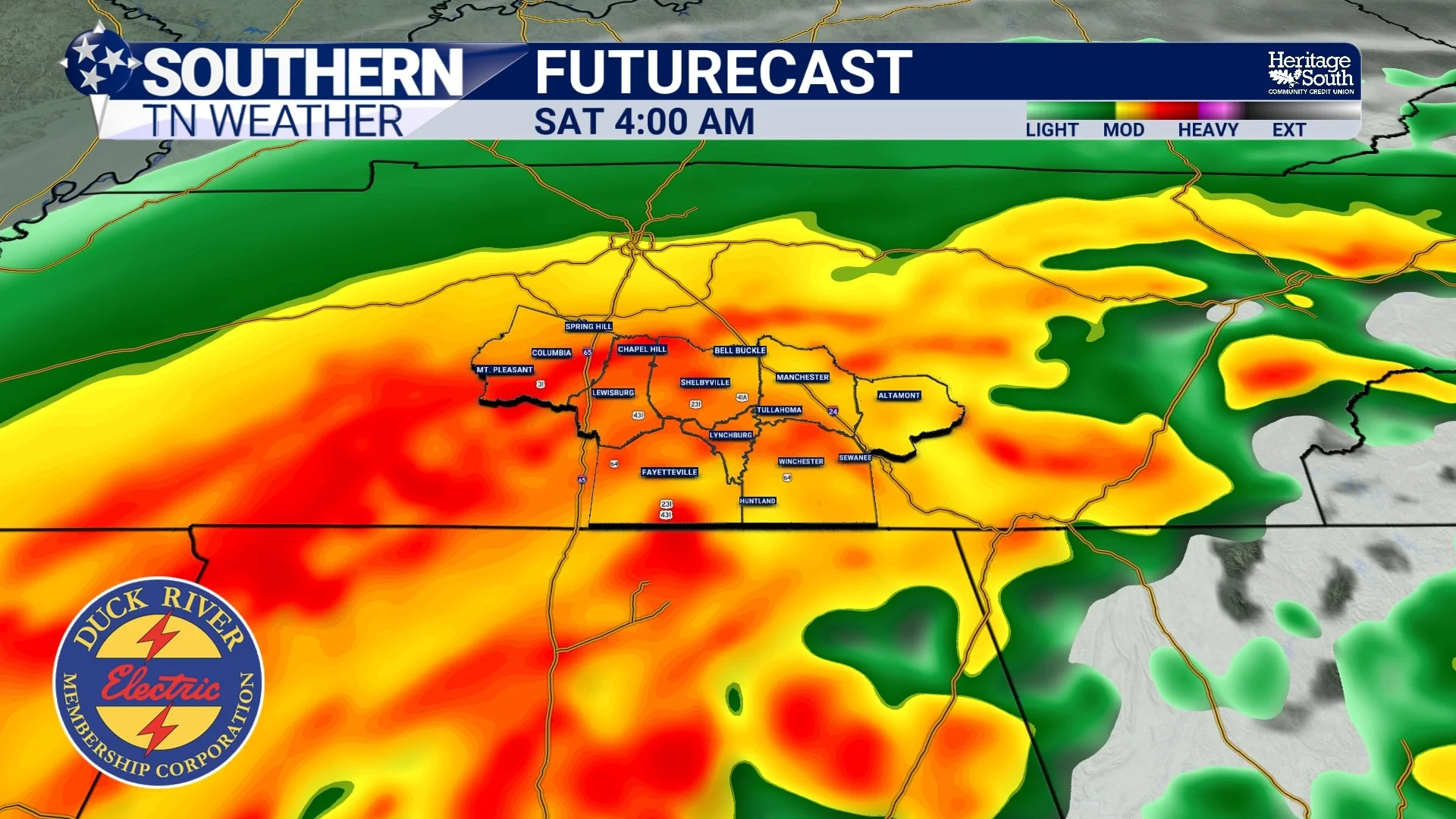
FUTURECAST - SATURDAY MORNING
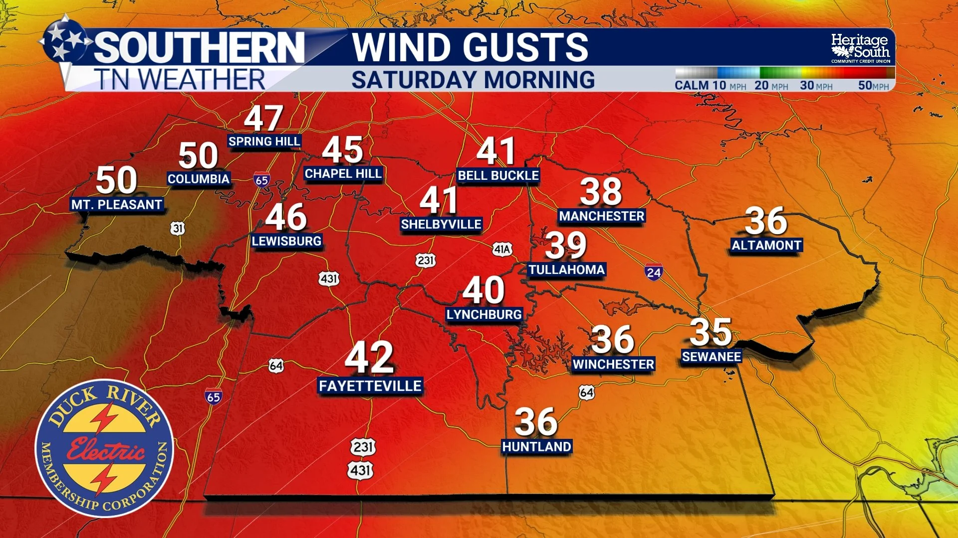
WIND GUSTS - SATURDAY MORNING
Flooding and Tornadoes: What Are the Risks?
While widespread rainfall will certainly be beneficial for our ongoing drought, the intensity of tropical downpours creates some concern for localized flooding. Tropical systems are extremely efficient at transporting moisture, and individual rain bands can produce very heavy rainfall rates over relatively short periods. Even though Isaias will be moving fairly quickly, locations that experience repeated heavy rain bands could receive substantially higher totals than surrounding communities. The Weather Prediction Center continues to highlight the potential for flash, urban and river flooding across portions of the Southeast as the system moves inland, with the greatest rainfall concerns extending from the Gulf Coast into portions of the southern Appalachians. Here in Southern Middle Tennessee, a Flood Watch is in effect for portions of the region, and the watch area has been expanded eastward across portions of the Cumberland Plateau as the forecast track of Isaias has shifted slightly east. The greatest concern will be low-lying areas, poor-drainage locations, smaller creeks and roadways where water can accumulate quickly.
And yes, even though we're dealing with moderate to extreme drought, flooding is still possible. Dry soil doesn't automatically prevent water from soaking in, but prolonged drought can sometimes contribute to crusting or compaction that limits infiltration. When rainfall rates become intense enough to exceed the ground's ability to absorb water, runoff can develop regardless of how dry conditions were beforehand.
The other concern is the possibility of brief tropical tornadoes. As we've discussed throughout the week, tropical systems can produce considerable low-level wind shear, allowing individual showers and thunderstorms to develop rotation even when lightning and thunder aren't particularly impressive. The tornado threat for Southern Middle Tennessee currently remains LOW, but not zero. A few brief spin-up tornadoes will be possible Saturday as the remnant circulation moves through, particularly within any stronger rain bands that develop. These tornadoes can form and dissipate quickly, sometimes with very little advance warning, which is why having multiple reliable ways to receive weather alerts will be important. I don't want anyone interpreting this as a forecast for a major tornado outbreak. That's NOT what we're expecting. Our primary concerns remain strong winds and heavy rainfall, but the tornado potential is something we'll continue monitoring closely as the circulation moves inland.
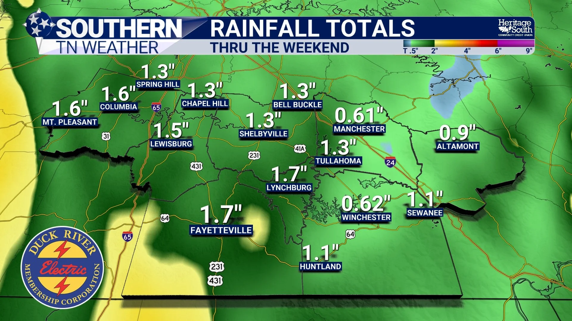
RAINFALL TOTALS - THRU THE WEEKEND
Sunday: Gradual Improvement as Isaias Pulls Away
Thankfully, Sunday should bring improving weather as the remnants of Isaias accelerate northeastward toward the Ohio Valley and central Appalachians. By that point, the system should have weakened considerably and transitioned away from its tropical characteristics, allowing the strongest winds and heaviest rainfall to gradually move away from Southern Middle Tennessee. We may still have some lingering showers, mist or drizzle Sunday morning, especially across our eastern counties and the Cumberland Plateau. However, rainfall coverage should gradually decrease through the day, with the last of the activity expected to clear the region by late Sunday afternoon or evening.
Winds will also begin relaxing as the pressure gradient weakens behind the departing system. It may remain breezy for a while, particularly during the morning, but conditions should become considerably more manageable compared to Saturday. Sunday certainly won't be the prettiest day we've ever experienced, but it should be a noticeable improvement over Saturday. If you've got outdoor activities planned for Sunday afternoon, there's a better chance of finding some workable weather, although damp ground and lingering clouds may still be issues. By Sunday night, we should finally be putting Isaias behind us.
Next Week: Back to Beautiful October Weather
After all the excitement this weekend, next week looks remarkably quiet. High pressure will rebuild across the region, bringing sunshine, comfortable humidity and another extended stretch of dry weather to Southern Middle Tennessee. Afternoon temperatures will generally return to the lower and middle 80s, which is a little warmer than average for the middle of October. Overnight lows should settle into the 50s and lower 60s, with some of our typically cooler locations potentially dipping a little lower under clear skies.
Unfortunately, the return of dry weather also means we won't immediately transition into a prolonged wet pattern following Isaias. While this weekend's rainfall should provide some much-needed drought relief, it won't necessarily eliminate our longer-term moisture deficits. We'll have to see exactly how much rain falls before determining how substantial that improvement may be. For now, though, I think we can all agree that a quiet stretch of weather next week will be more than welcome after what we're expecting Saturday.
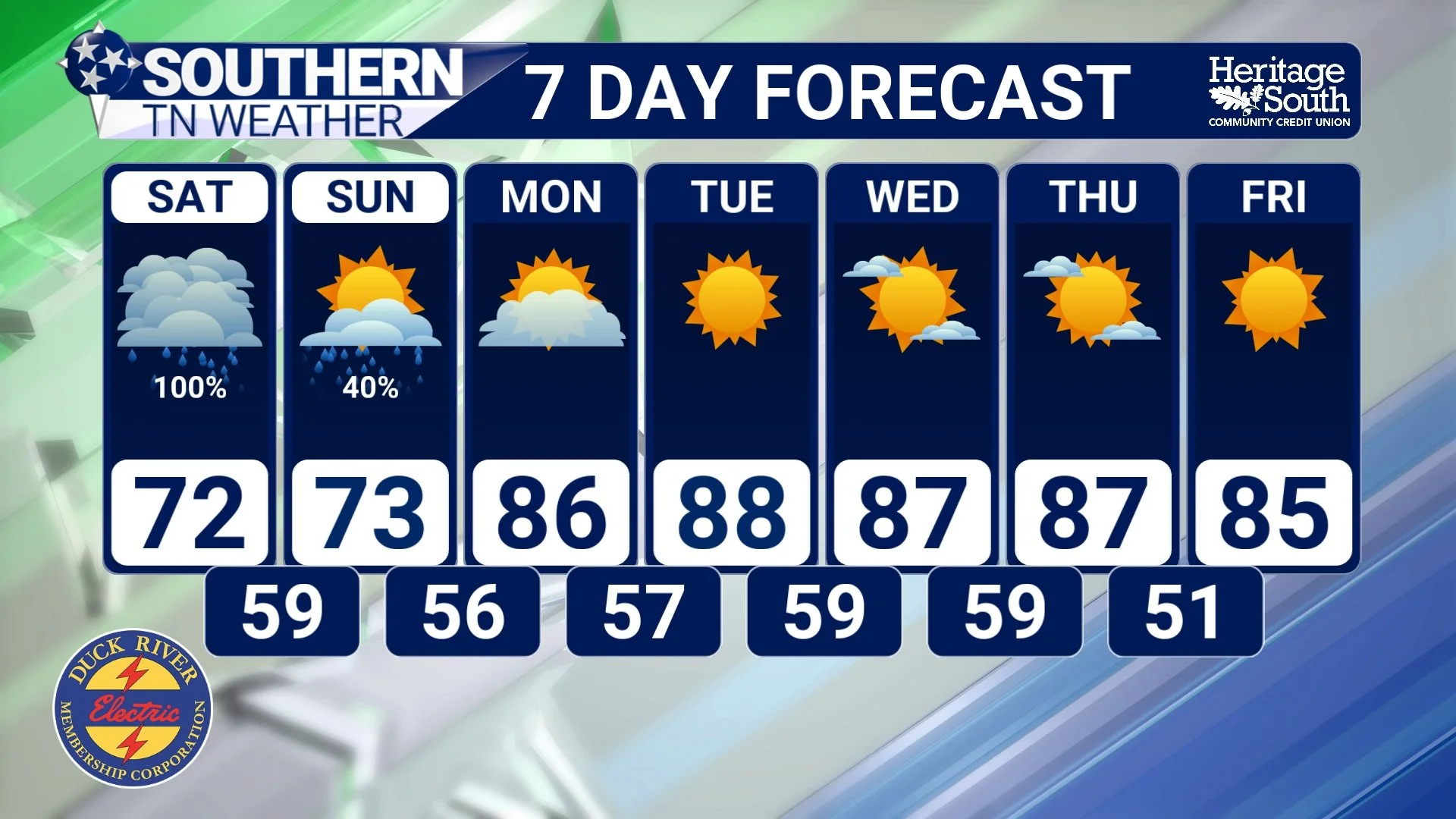
STNWX 7-DAY FORECAST
The Bottom Line 🧾
🌀 Hurricane Isaias has strengthened into a Category 3 hurricane, with maximum sustained winds of 120 MPH as of Friday morning. Landfall is expected along the northern Gulf Coast later this evening.
🏈 Friday evening football games should generally be okay, with increasing clouds and breezy conditions. Most locations should remain dry before rainfall begins increasing overnight.
🌧️ Rain will begin spreading into Southern Middle Tennessee between approximately midnight and 6 AM Saturday, becoming widespread through much of Saturday morning.
☔ Saturday is expected to be a washout for many outdoor activities, although rainfall may become more scattered at times during the afternoon.
💦 Widespread rainfall totals of 1 to 3 inches are expected, with locally higher amounts possible where heavier tropical bands repeatedly move across the same locations.
⚠️ A Flood Watch is in effect for portions of Middle Tennessee, including areas of the Cumberland Plateau, due to the potential for localized flash flooding.
💨 Wind gusts of 40 MPH or greater are expected Saturday, with some locations potentially experiencing gusts approaching or exceeding 50 MPH.
🌳 A Wind Advisory is in effect for all of Middle Tennessee. Downed tree limbs, scattered power outages and hazardous travel conditions will be possible.
🌪️ The tornado threat remains LOW, but not zero. A few brief spin-up tornadoes could develop within tropical rain bands Saturday.
⏰ The most impactful weather is expected from Saturday morning through Saturday night, with strong winds and periods of moderate to heavy rainfall.
🌥️ Conditions will gradually improve Sunday as Isaias pulls away, although lingering showers and breezy conditions may continue for part of the day.
☀️ Warm, dry and pleasant weather returns Monday, with highs generally in the 80s and overnight lows in the 50s and 60s through much of next week.
📰 Reminder: The Southern Tennessee Weather Blog, presented by Heritage South Community Credit Union, is updated Monday through Friday with fresh, locally tailored forecasts you can trust.
