
Why Can October Weather Feel Like Summer One Day and Winter the Next?

The Southern Tennessee Weather Blog is proudly presented by Heritage South Community Credit Union.
We Help When Others Won’t!
Visit https://www.heritagesouth.org/ today to see how HSCCU can help YOU!
If you've lived in Southern Middle Tennessee for any length of time, you probably know that October has a bit of an identity crisis when it comes to the weather. One afternoon, you're wearing shorts, running the air conditioning and wondering whether summer ever actually ended. A few days later, you're digging through the closet looking for a jacket, turning on the heat and wondering how temperatures managed to drop so dramatically in such a short period. And wouldn't you know it, we're about to experience a pretty good example of that exact situation this week!
High temperatures across Southern Middle Tennessee are expected to climb into the middle and upper 80s through Thursday, with some locations potentially flirting with 90 degrees. In fact, temperatures could get warm enough to challenge daily record highs in portions of Middle Tennessee. However, a strong cold front is expected to move through our region Friday, bringing a substantial cooldown just in time for the weekend. By Saturday afternoon, some communities may struggle to climb much beyond the middle 60s, while overnight temperatures could fall into the 30s and 40s by Sunday morning.
That's a pretty remarkable temperature swing for a period of just a few days, but it's also something October is particularly good at producing. So, why does this happen? Why can the same month deliver summerlike afternoons, chilly mornings and even the occasional frost? The answer involves the changing seasons, the jet stream and a pretty intense battle between warm and cold air masses.
October Is a Month Caught Between Two Seasons
To understand why October weather can change so dramatically, we first need to understand what's happening across the Northern Hemisphere as we transition from summer into winter. During the summer months, the Northern Hemisphere receives more direct sunlight, allowing the ground and lower atmosphere to absorb substantial amounts of solar energy. By October, however, the sun is getting noticeably lower in the sky, daylight hours are becoming shorter and areas farther north are cooling at a much faster rate.
Here in Southern Middle Tennessee, we haven't completely lost our ability to experience summerlike warmth. The ground can still heat up considerably during sunny afternoons, especially when winds are transporting warmer air northward from the Gulf Coast region. Meanwhile, areas of Canada and the northern United States are beginning to experience much colder temperatures as autumn progresses. That creates an increasingly sharp contrast between the warmer air to our south and the colder air building to our north. During October, Southern Middle Tennessee often finds itself right in the middle of those competing air masses, and relatively small changes in the overall weather pattern can determine which one takes control.
One week, a large area of high pressure may allow warm air to spread northward, sending afternoon temperatures into the 80s or even lower 90s. A few days later, a strong cold front can sweep through the region and replace that warmth with air originating much farther north. The calendar might say October, but the atmosphere doesn't necessarily switch from summer to fall overnight. Instead, we experience a series of transitions as the colder season gradually gains ground.
The Jet Stream Is the Traffic Controller
One of the biggest reasons October weather can change so quickly is the jet stream. You've probably heard me mention the jet stream in previous blogs, but it's worth revisiting because it plays an enormous role in determining whether we're enjoying a warm autumn afternoon or shivering through an unusually cold morning. The jet stream is a relatively narrow corridor of strong winds located several miles above the Earth's surface. It generally flows from west to east, although it frequently develops large northward and southward bends as weather systems move across North America. Those bends are extremely important because they help determine where warmer and colder air masses are transported.
When the jet stream develops a large northward bulge, known as a ridge, warmer air often becomes established underneath it. Air sinking beneath upper-level ridges tends to discourage cloud formation, allowing sunshine to heat the ground efficiently. When that ridge is accompanied by southerly or southwesterly winds near the surface, temperatures can climb well above what we'd normally expect for the time of year. On the other hand, when the jet stream dips southward into a trough, colder air from higher latitudes can begin moving toward the central and eastern United States. Troughs are also frequently associated with developing low-pressure systems and cold fronts, which can help push the colder air farther south.
Think of the jet stream as a giant atmospheric highway that helps guide weather systems across the country. When the highway bends north, we can end up on the warm side of the pattern. When it takes a sharp turn south, we may suddenly find ourselves dealing with a much colder air mass. And during October, those bends can become particularly influential because the temperature difference between northern and southern parts of the continent is growing.
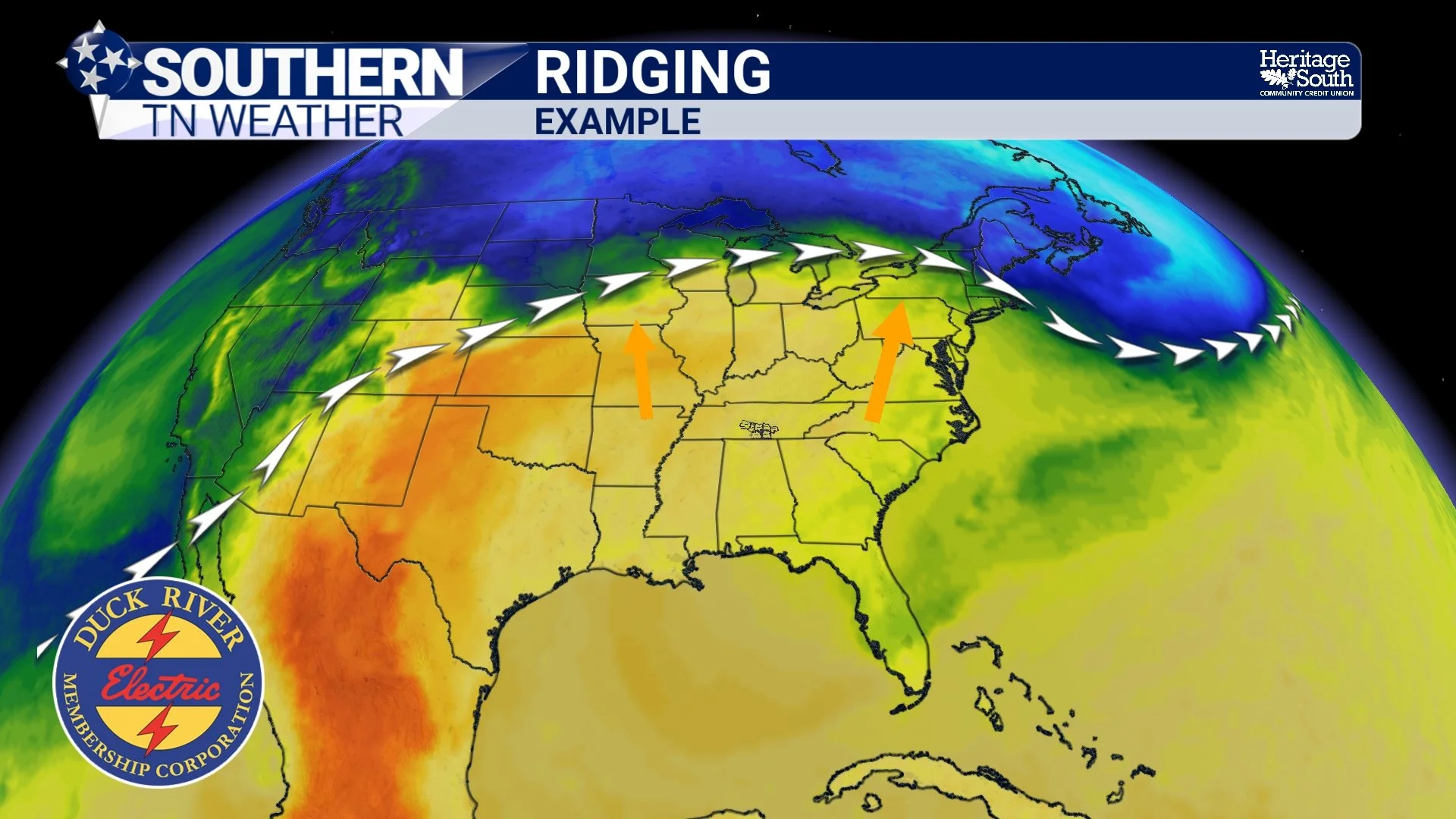
RIDGING - EXAMPLE
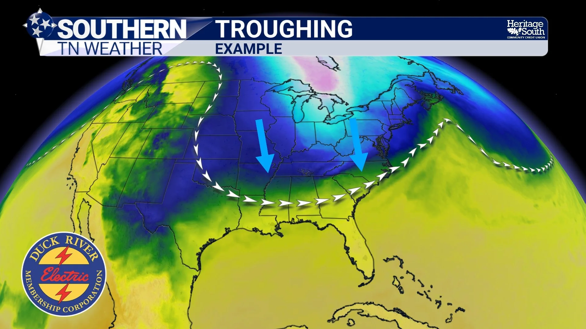
TROUGHING - EXAMPLE
Cold Fronts Can Change Everything in a Matter of Hours
Of course, the jet stream doesn't directly determine the temperature at your house. Much of the actual change we experience at ground level occurs when different air masses move into the region, often separated by cold fronts. A cold front marks the leading edge of an advancing cooler air mass. Because cold air is generally denser than warm air, it tends to spread underneath the warmer air already in place. As the front moves through, winds frequently shift direction, atmospheric pressure begins changing and temperatures can fall rather quickly. However, not all cold fronts are created equal. Some bring only a modest temperature drop of five or ten degrees, while others can produce much more dramatic changes. The strength of the temperature contrast between the two air masses, the speed of the front and the origin of the incoming air all help determine how significant the cooldown becomes.
That's especially relevant to our forecast this week. A strong upper-level disturbance moving across the northern United States is expected to help drive a polar cold front southward into Southern Middle Tennessee on Friday. Ahead of the front, we'll remain underneath a warm upper-level ridge, allowing temperatures to climb well above normal. Behind the front, winds will turn northerly or northwesterly, transporting a much cooler air mass into the region.
Interestingly, a strong cold front doesn't necessarily mean we're going to experience strong thunderstorms. Cold fronts often produce showers and storms because advancing cooler air forces warmer air upward, but sufficient moisture and atmospheric instability must also be present. In this particular situation, forecast guidance suggests the front may arrive with relatively limited moisture. That means we could experience a very noticeable temperature drop without much rainfall at all. Unfortunately, given our ongoing drought, that's not exactly the combination we'd prefer.
Why Do Temperatures Sometimes Fall Even More at Night?
There's another interesting part of this equation that can make October temperature swings feel even more dramatic: nighttime cooling. During the day, sunlight warms the Earth's surface, which then transfers heat into the air immediately above it. Once the sun sets, the ground begins losing energy through infrared radiation, and temperatures start falling. How quickly that cooling occurs depends on several factors, including cloud cover, wind speed, humidity and the characteristics of the surrounding terrain. Clear skies allow the surface to lose heat more efficiently, while clouds can absorb and reemit some of that infrared energy back toward the ground, slowing the cooling process. Light winds can also allow colder air to collect near the surface, especially in sheltered valleys and low-lying areas.
This is why temperatures can vary considerably over relatively short distances on chilly autumn mornings. A location on a hilltop might remain in the lower 40s while a nearby valley drops into the middle 30s. The colder, denser air tends to drain downhill and settle into lower elevations, creating what meteorologists call cold-air pooling. Our region has plenty of terrain features capable of producing those differences, from the hills and hollers of Bedford, Marshall and Moore counties to the higher terrain and valleys around the Cumberland Plateau.
It also explains why the first frost of the season doesn't necessarily occur everywhere at the same time. Frost can form when exposed surfaces cool to freezing or below, even when the official air temperature measured several feet above the ground remains slightly above 32 degrees. So, when we begin talking about overnight temperatures in the 30s, it doesn't automatically mean widespread frost is guaranteed. But it certainly becomes something worth monitoring, especially in our colder, sheltered locations.
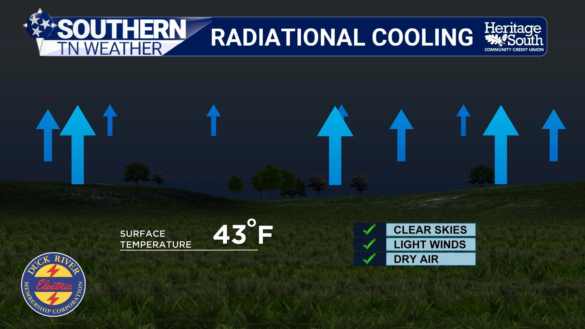
RADIATIONAL COOLING
Why Is October Particularly Prone to These Swings?
You might be wondering why we seem to experience these dramatic changes so frequently in October compared to the middle of summer or winter. During July and August, the overall weather pattern across much of the southern United States is often dominated by warm air and expansive areas of high pressure. Cold fronts can still reach Southern Middle Tennessee during summer, but the air behind them generally isn't nearly as cold as what becomes available later in the year. During the heart of winter, on the other hand, colder air masses are much more common across the United States. We can certainly experience dramatic warmups and cooldowns in January and February, but the background temperature pattern is already considerably colder.
October falls into a particularly interesting transition period. There's still plenty of warmth available across the southern United States, while increasingly cold air masses are developing across Canada and the northern states. The jet stream is also becoming more active as the temperature contrast between those regions strengthens. That means Southern Middle Tennessee can alternate between very different air masses in a relatively short amount of time. A persistent ridge might deliver several afternoons that feel more like late August, while a passing trough and cold front can suddenly remind us that November is right around the corner.
And because the sun is getting lower in the sky and the nights are becoming longer, the cooler air masses that arrive behind autumn cold fronts can produce much chillier mornings than similar systems would during the summer. In other words, October isn't necessarily confused about what season it wants to be. We're simply experiencing the atmosphere's gradual transition toward winter, and that transition rarely happens in a perfectly smooth fashion.
This Week's Forecast: Summerlike Warmth Before a Major Cooldown
Now that we've discussed the science behind these temperature swings, let's look at how the pattern is expected to unfold across Southern Middle Tennessee this week.
Monday through Thursday: A strengthening upper-level ridge and surface high pressure will keep warm, mostly dry weather in place across the region. Afternoon highs will generally reach the middle and upper 80s, with some locations potentially approaching 90 degrees Tuesday through Thursday. These temperatures are considerably warmer than normal for the middle of October, and daily record highs could be challenged in portions of Middle Tennessee. Overnight temperatures will generally remain in the 50s and lower 60s, with some patchy fog possible during the early morning hours.
Friday: Our attention turns to a strong cold front approaching from the northwest. Forecast models still differ somewhat on the exact timing, with some guidance bringing the front through early Friday and other solutions favoring a later passage. Temperatures may still reach the 70s or lower 80s in some locations before cooler air becomes established, depending on when the front arrives. Winds will shift toward the northwest or north, and breezy conditions are expected as the colder air begins moving into the region. At this point, the front appears likely to move through with little, if any, meaningful rainfall. That's good news from a severe-weather standpoint, but unfortunately, it won't do much to help our ongoing drought.
Saturday: This is when the temperature change should become much more noticeable. Afternoon highs could struggle to climb beyond the middle and upper 60s across much of the region, which would feel considerably different compared to the near-90-degree warmth earlier in the week. Northerly winds may remain rather breezy, adding an extra chill to the air, especially for anyone attending outdoor events.
Sunday: The coldest temperatures of the season so far may arrive Sunday morning. Current guidance suggests overnight lows generally in the upper 30s and 40s, with some of our colder valleys and sheltered locations potentially dropping into the middle 30s. That could introduce at least an isolated frost concern, although confidence in the exact temperatures and frost coverage remains limited this far out. Afternoon temperatures should recover into the middle 60s to lower 70s under generally pleasant autumn conditions.
It's important to emphasize that the strength and timing of this cold front are still subject to change. Some forecast models are more aggressive with the incoming cold air than others, and small differences in cloud cover, wind speeds and the eventual position of high pressure could significantly influence how cold our mornings become. I'm not ready to promise widespread frost or a freeze across Southern Middle Tennessee, but the possibility of our first temperatures in the 30s this fall is becoming increasingly worth watching.
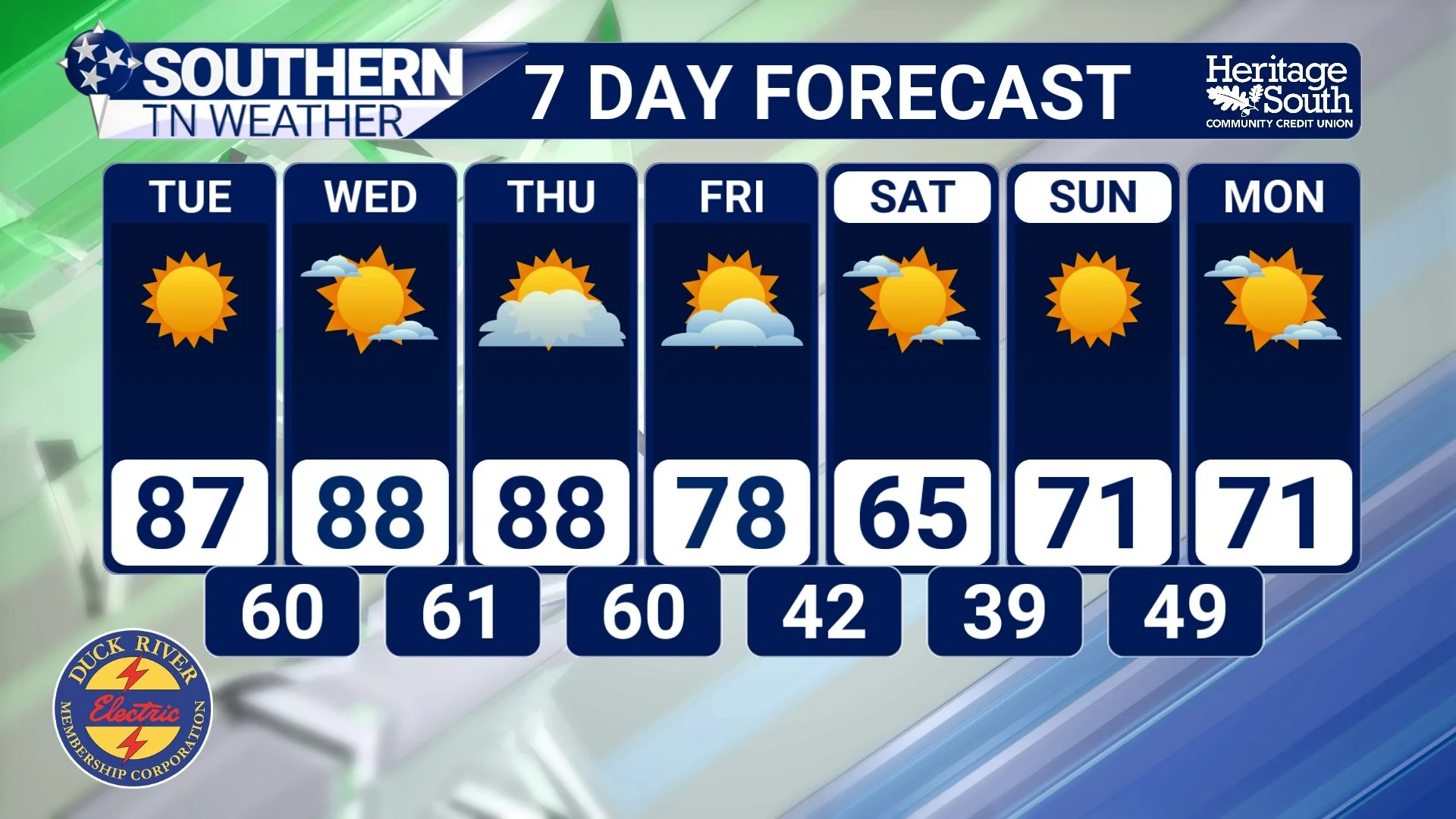
STNWX 7-DAY FORECAST
The Bottom Line 🧾
🍂 October is a transition month when warm air across the southern United States frequently competes with increasingly cold air developing farther north.
🌬️ The jet stream plays a major role in these temperature swings by helping steer warm and cold air masses across the country.
☀️ Upper-level ridges often favor warmer, drier weather, while troughs can help drive colder air southward.
🌡️ Southern Middle Tennessee will experience well-above-normal temperatures through Thursday, with highs in the middle and upper 80s and some locations approaching 90 degrees.
🔥 Record high temperatures could be challenged across portions of Middle Tennessee Tuesday through Thursday.
🌧️ A few isolated showers or storms are possible Wednesday, mainly north of Interstate 40, but most locations will remain dry.
🥶 A strong cold front is expected Friday, bringing a significant temperature drop into the weekend.
💨 Breezy northerly winds may make Saturday feel even cooler, with highs potentially only reaching the middle and upper 60s.
❄️ Overnight temperatures could fall into the 30s and 40s by Sunday morning, with an isolated frost concern in some of our colder locations.
⚠️ Widespread frost or freezing temperatures are NOT guaranteed, and forecast details will continue to change as we get closer.
🌵 Unfortunately, the cold front currently looks relatively dry, meaning additional drought relief is unlikely through the upcoming weekend.
📰 Reminder: The Southern Tennessee Weather Blog, presented by Heritage South Community Credit Union, is updated Monday through Friday with fresh, locally tailored forecasts you can trust.
