
Extreme Drought Expands Across The Area But MUCH-Needed Rain Is Coming!

The Southern Tennessee Weather Blog is proudly presented by Heritage South Community Credit Union.
We Help When Others Won’t!
Visit https://www.heritagesouth.org/ today to see how HSCCU can help YOU!
Well, here we are again. Another Thursday, another Drought Monitor update, and unfortunately, another step in the wrong direction for portions of Southern Middle Tennessee. Despite the beneficial rainfall we received last weekend, the latest U.S. Drought Monitor shows Extreme Drought (D3) expanding across portions of the upper Duck River Basin, while Severe Drought (D2) continues to cover a substantial portion of our region. After an exceptionally hot and dry September, our drought situation remains serious, and a single weekend of rainfall simply wasn't enough to undo the damage.
However, there's a rather interesting twist to this week's update. While the drought continues to worsen on paper, we're now tracking what could become our most substantial widespread rainfall event in quite some time. Hurricane Isaias is expected to move inland from the northern Gulf Coast Friday night, with its remnants bringing periods of heavy tropical rainfall and gusty winds to Southern Middle Tennessee on Saturday. In fact, some locations could receive several inches of rain in a relatively short period, potentially providing meaningful drought relief while simultaneously creating a flash flooding concern. Yes, we're going to spend part of today's drought blog talking about the possibility of TOO MUCH rain. Mother Nature apparently doesn't believe in doing anything halfway. 😂
Extreme Drought Expands, Despite Last Weekend's Rain
The latest Drought Monitor, released Thursday morning using conditions observed through Tuesday, October 6, continues to paint a concerning picture across Middle Tennessee. Extreme Drought, the second-highest classification on the five-category drought scale, now covers portions of the upper Duck River Basin, along with areas of northwestern Wayne County and far southwestern Perry County. Severe Drought remains widespread across much of the southern tier of Middle Tennessee, while Moderate Drought continues across a large portion of the remainder of the region. For some perspective, the Drought Monitor classifications range from D0, which represents abnormally dry conditions, through D4, which represents exceptional drought. D3 Extreme Drought is only one category below the most severe classification possible. It's a designation that reflects more than just brown grass or a few weeks without rain. It indicates substantial moisture shortages that can affect soils, streams, agriculture and water availability.
The Nashville Weather Service's latest drought statement shows that approximately 4.81% of its forecast area is now experiencing Extreme Drought, compared to 2.20% just one week ago. That's more than double the percentage of the area classified as D3, even though portions of Middle Tennessee received beneficial rainfall over the weekend. Meanwhile, approximately 43.79% of the forecast area is experiencing Severe Drought or worse. That may sound contradictory at first. If we finally received rain last weekend, why would the drought continue getting worse? The answer comes down to the difference between receiving rainfall and actually recovering from a prolonged moisture deficit.
The Drought Monitor doesn't simply look at how much rain fell over the previous seven days. It incorporates precipitation deficits, soil moisture, streamflow, vegetation conditions and other indicators to determine how drought is affecting an area. A beneficial rain can improve conditions near the surface without immediately correcting the much larger moisture shortages that have accumulated over several weeks or months. There's also an important timing detail. This week's Drought Monitor reflects conditions through Tuesday morning, while some of the precipitation information included in the accompanying drought statement extends through Wednesday. That means not every rainfall observation shown in the report necessarily contributed to this week's drought classification.
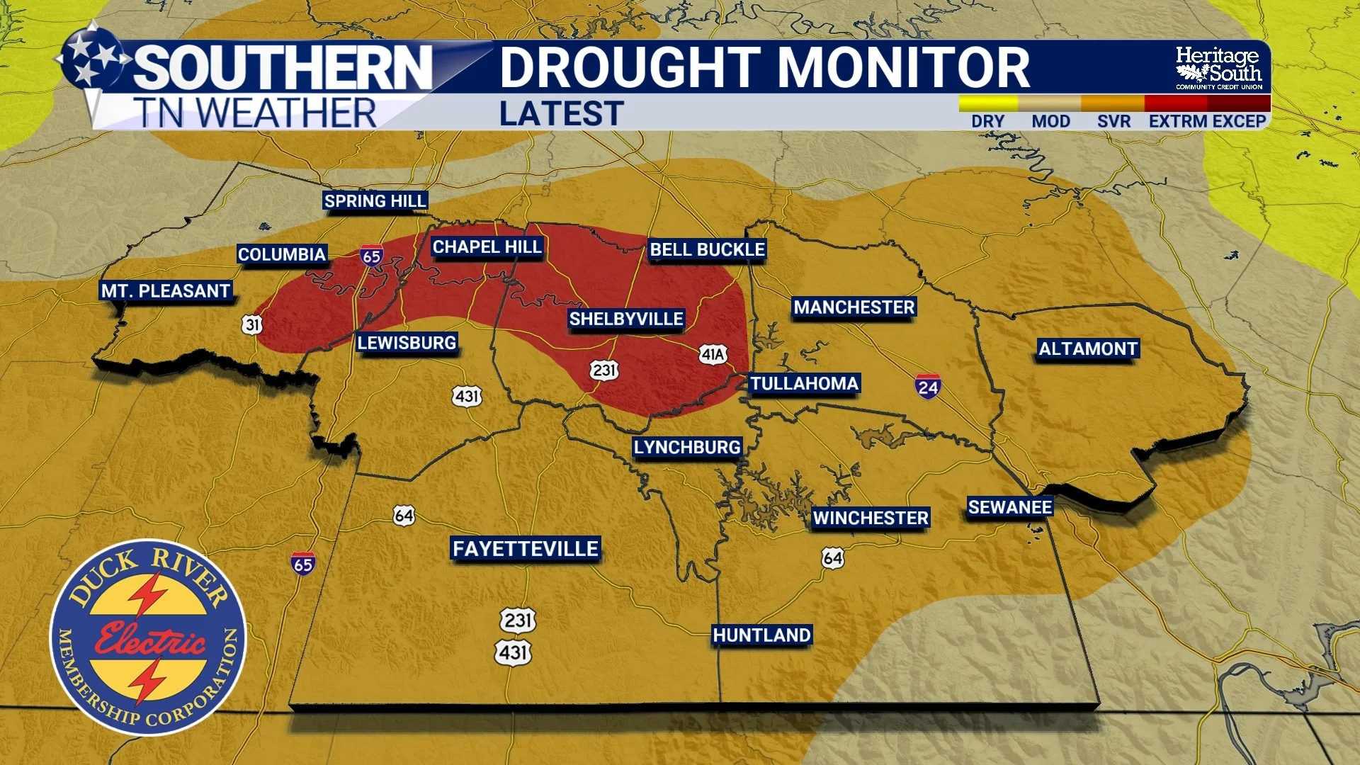
DROUGHT MONITOR - LATEST
Just How Dry Has It Been?
One of the most striking pieces of information in the latest drought statement involves rainfall over the past 30 days. Across much of West and Middle Tennessee, precipitation totals have generally remained at or below three inches, with some locations receiving three-quarters of an inch or less. However, the percentage-of-normal rainfall map tells an even more dramatic story. Across a large portion of Southern Middle Tennessee, rainfall over the past 30 days has amounted to 30% or less of what we would normally expect for this time of year.
Think about that for a moment. If a location would typically receive three inches of rainfall during a particular 30-day period, receiving just 5% of normal would mean only 0.15 inches fell during that entire stretch. That's barely enough to wet the ground, much less replenish the moisture we've lost through evaporation and vegetation. Of course, rainfall has not been distributed evenly across our region. Some communities received considerably more rain than others last weekend, and a few locations benefited from heavier, more persistent showers. But when you zoom out and examine the overall moisture picture, the deficits remain substantial.
This is also why the drought has developed so rapidly. The National Weather Service notes that much of Tennessee has experienced significant drought development and deterioration over the past four weeks and longer. Our prolonged stretch of above-normal temperatures during September certainly didn't help, as warmer weather increased the demand for moisture while rainfall remained scarce. The result is a landscape that has been running a moisture deficit for quite some time, and we're only beginning to make deposits back into that account.
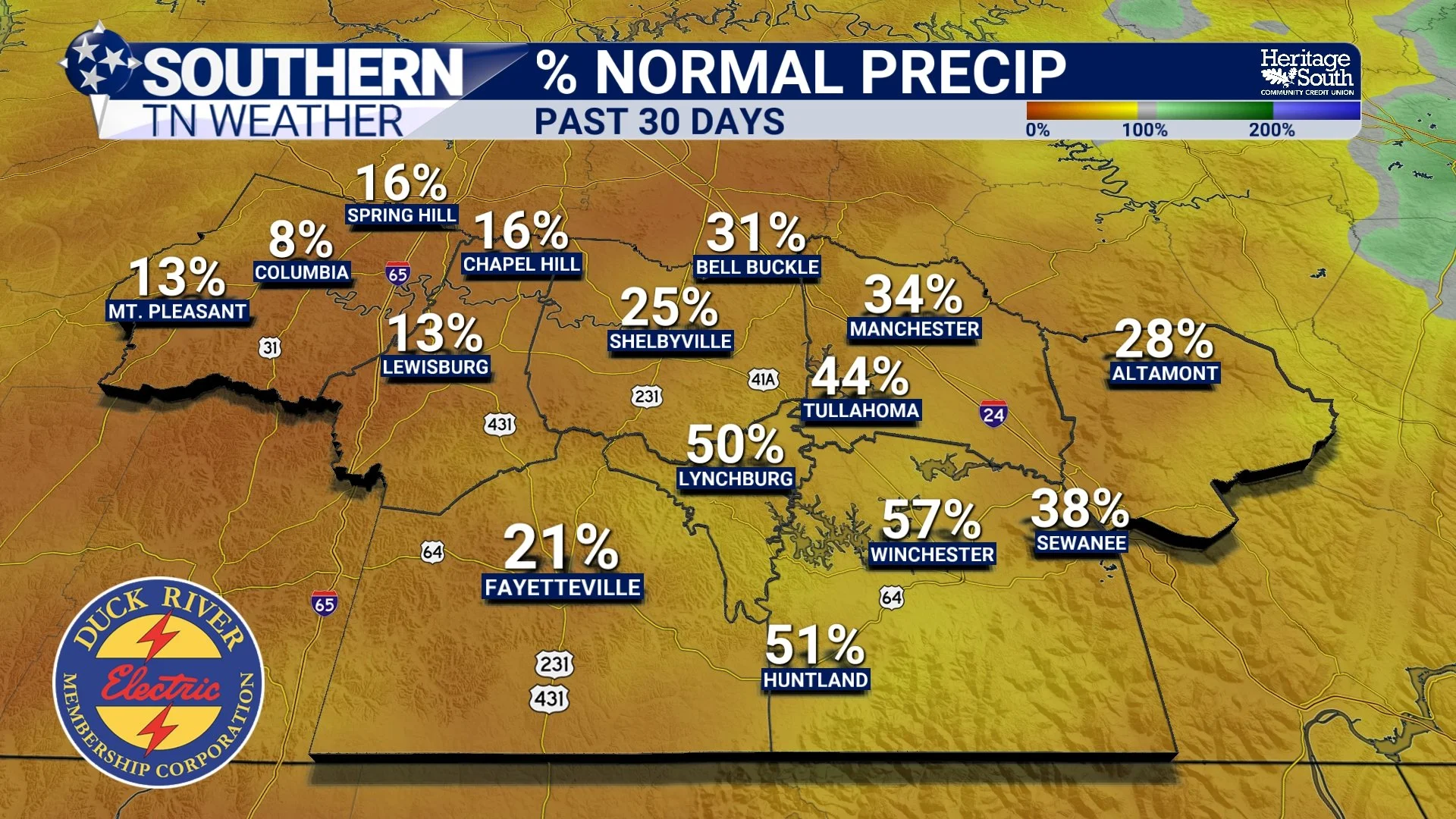
PERCENT NORMAL PRECIP
The Impacts Go Well Beyond Brown Grass
Although the growing season is gradually winding down, the effects of our drought extend well beyond lawns and gardens. The latest drought statement notes that soil moisture remains a concern, while water availability in agricultural storage ponds is becoming increasingly problematic. Impacts involving livestock have also been reported, particularly where water supplies have become limited. Our streams and rivers have also reflected the prolonged dry pattern. While lower streamflows are relatively common during the fall, the lack of rainfall has caused some waterways to run well below normal for this time of year. Recent rainfall has helped improve streamflow conditions somewhat, but those improvements have not been enough to eliminate the underlying concerns.
This is an important distinction because drought recovery doesn't happen everywhere at the same speed. The upper few inches of soil may respond relatively quickly to a good soaking rain, allowing grass and vegetation to temporarily perk up. Deeper soil moisture, groundwater and some water supplies can take considerably longer to recover, particularly when the preceding dry period has been prolonged. It's a little like trying to refill a nearly empty savings account. One decent paycheck certainly helps, but it doesn't automatically replace everything that disappeared over the previous several months. Fortunately, our next opportunity for a much larger deposit is quickly approaching.
Hurricane Isaias Could Bring Significant Drought Relief... And Flooding Concerns
This is where our forecast takes a rather dramatic turn. Hurricane Isaias is expected to make landfall along the northern Gulf Coast late Friday before accelerating northward, bringing a surge of tropical moisture into Southern Middle Tennessee on Saturday. We’re expected to see 1 to 3 inches, with locally higher amounts possible. There is also a lower-probability scenario in which locations repeatedly affected by tropical rain bands receive substantially higher totals.
If those amounts materialize, we could see meaningful improvement in our short-term drought conditions. Widespread rainfall of one to three inches would provide much-needed moisture to dry soils, help replenish streams and offer some relief to agricultural areas that have been struggling with limited rainfall. However, there's an important catch: the amount of rain we receive is only part of the equation. How quickly it falls matters just as much.
We've discussed this in previous blogs, but soil can only absorb water at a certain rate. That rate depends on several factors, including soil type, compaction, vegetation, slope and existing moisture conditions. Prolonged dry weather can sometimes leave the ground crusted or compacted, reducing how efficiently intense rainfall initially soaks in. That doesn't mean dry ground is incapable of absorbing water, but it does mean an extremely heavy downpour can produce significant runoff when rainfall rates exceed the soil's ability to absorb it. Tropical rain bands are particularly capable of producing those intense rainfall rates. Even though Isaias is expected to move northward fairly quickly, individual bands could repeatedly cross the same locations, producing several inches of rainfall over a relatively short period.
That's why the National Weather Service has issued Flood Watches for all of our area, with the greatest concern generally centered on Saturday and Saturday night. Localized flash flooding could develop in low-lying areas, along smaller creeks and in locations where repeated heavy bands overwhelm drainage systems. And the concerns aren't limited to rainfall. Some stronger wind gusts of 30-40 MPH (potentially upwards of 50 MPH will be possible for a few of us). In other words, Isaias could provide exactly the kind of moisture our region desperately needs, but it may arrive much faster and with considerably more wind than we'd prefer.
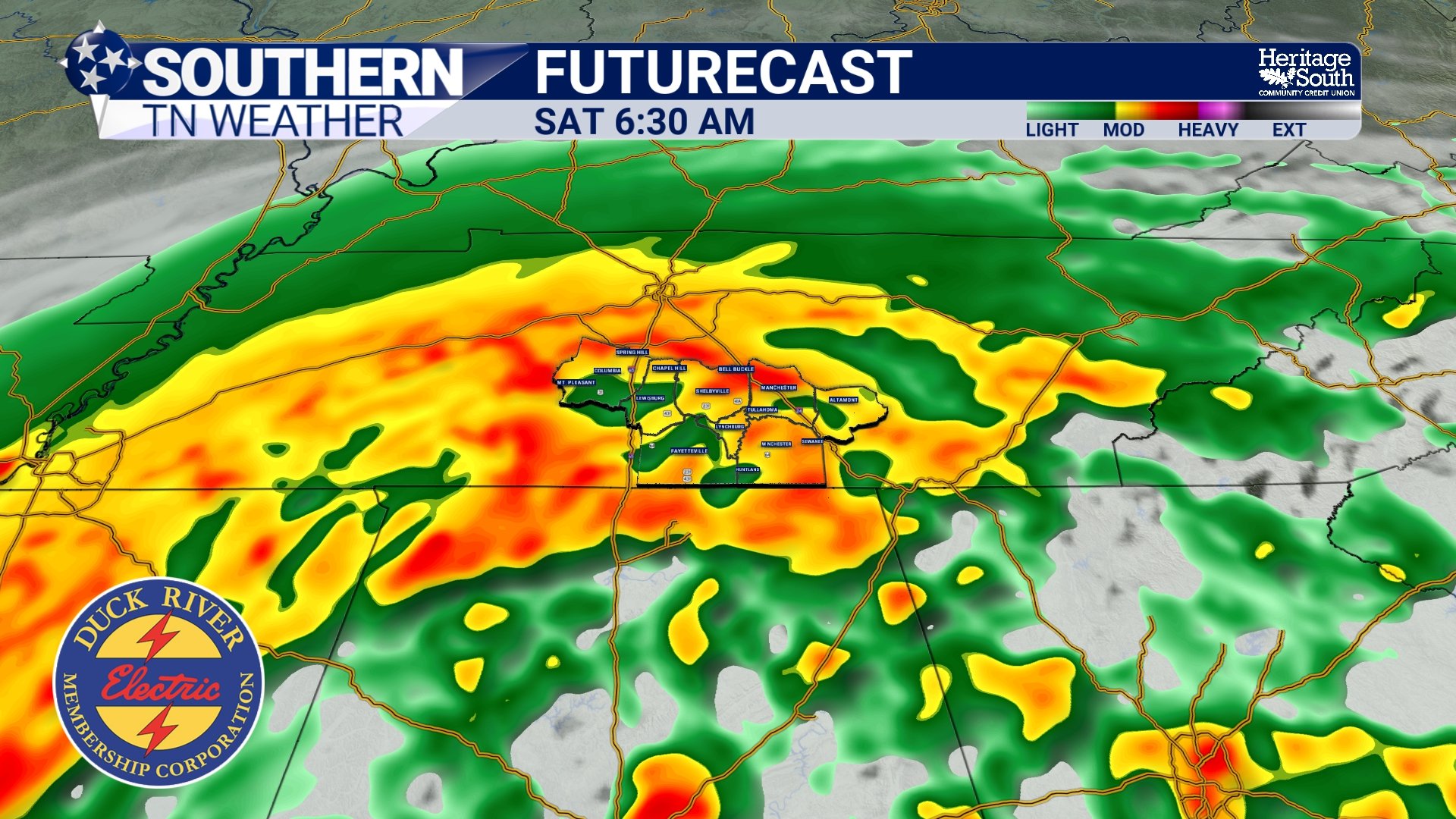
FUTURECAST - SATURDAY
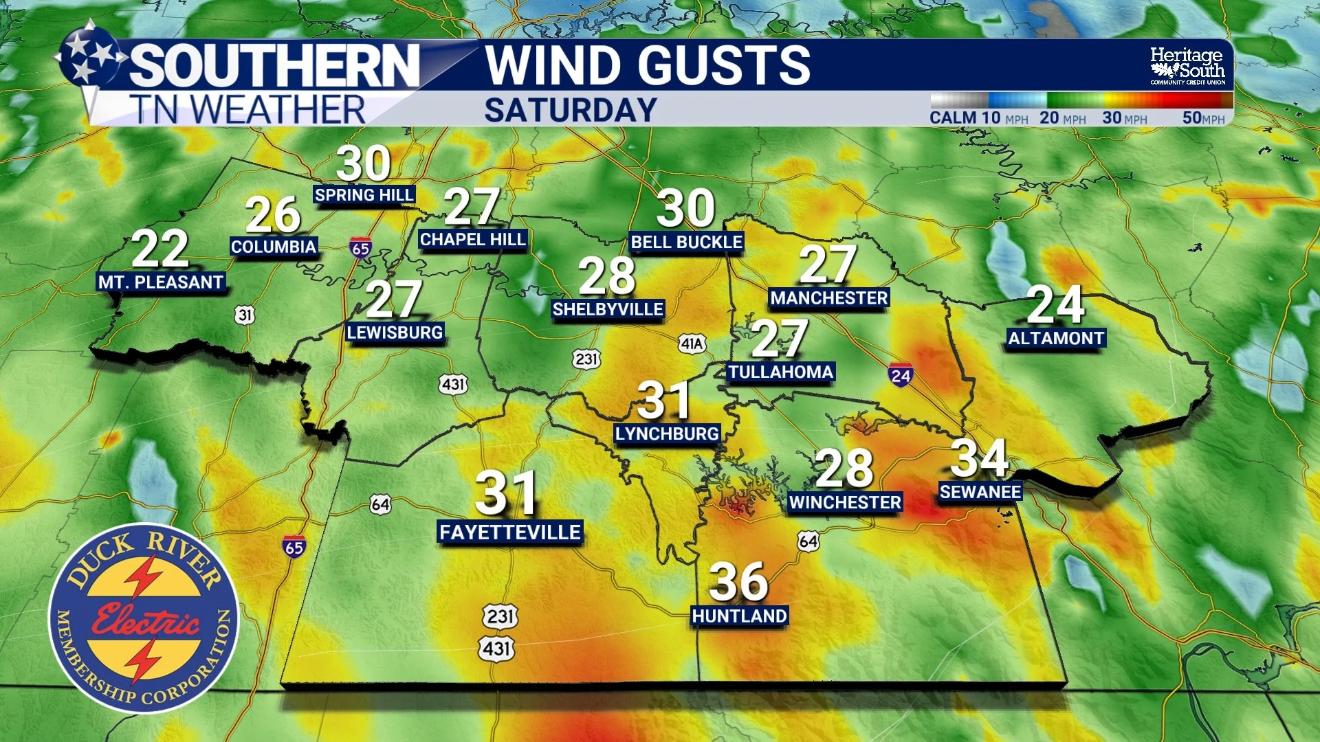
WIND GUSTS - SATURDAY
Will Isaias Finally End Our Drought?
That's the million-dollar question, and the answer is that it will depend on how much rain actually falls and where the heaviest amounts occur. If most of Southern Middle Tennessee receives a widespread one to three inches, I would expect at least some improvement in short-term moisture conditions. Locations that receive several inches could see a more substantial response, particularly in soil moisture and streamflow. However, even a significant tropical rainfall event doesn't automatically erase the deeper moisture deficits that have accumulated during our prolonged dry stretch. It's also worth remembering that the Drought Monitor is updated weekly. The rainfall from Isaias will occur after the cutoff for this week's map, meaning any resulting improvement would not be reflected until a future update.
Looking beyond the weekend, there is some encouraging news in the longer-range outlook. The Climate Prediction Center continues to favor above-normal precipitation across Tennessee for the October through December period, and the National Weather Service expects drought conditions to gradually improve as we move through the remainder of fall and into early winter. That doesn't guarantee every week will be wet, and it certainly doesn't mean the drought will disappear overnight. In fact, warm and dry weather is expected to return early next week, with afternoon highs climbing back into the 80s and overnight lows generally in the 50s and 60s. Still, if we can begin transitioning toward a pattern that delivers more frequent, widespread rainfall events, we'll have a much better opportunity to gradually work our way out of the drought.
For now, the immediate priority is getting through Isaias safely. We'll continue watching the track, timing and placement of the heaviest rainfall bands closely, particularly given the growing concern for gusty winds, localized flooding and brief tornadoes Saturday.
The Bottom Line 🧾
🌵 Extreme Drought (D3) has expanded across portions of the upper Duck River Basin, with additional areas of Extreme Drought in northwestern Wayne and far southwestern Perry counties.
🔴 The percentage of the Nashville forecast area experiencing Extreme Drought has increased from 2.20% last week to 4.81% this week, more than doubling.
🟠 Severe Drought (D2) remains widespread across much of Southern Middle Tennessee, while Moderate Drought continues across much of the remainder of Middle Tennessee.
🌧️ Despite beneficial rainfall last weekend, our longer-term moisture deficits remain substantial.
📉 Some locations across Southern Middle Tennessee have received 5% or less of their normal rainfall over the past 30 days.
🌊 Recent rainfall has helped improve streamflows somewhat, but some rivers and creeks remain well below normal for this time of year.
🐄 Dry soils, low agricultural pond levels and impacts to livestock remain concerns.
🌀 Hurricane Isaias is expected to bring widespread tropical rainfall Saturday, with approximately 1 to 3 inches possible across much of the region and locally higher amounts.
⚠️ Flood Watches are in effect for portions of Middle Tennessee, and localized flash flooding will be possible where heavy tropical rain bands repeatedly move across the same locations.
💨 Wind gusts of 30 to 40 MPH, locally stronger gusts and a few brief tropical tornadoes will also be possible Saturday.
🌱 Significant rainfall from Isaias could provide meaningful short-term drought relief, but one event will not necessarily eliminate our longer-term moisture deficits.
🍂 Longer-range outlooks favor above-normal precipitation through the remainder of fall and into early winter, offering some hope for gradual drought improvement.
📰 Reminder: The Southern Tennessee Weather Blog, presented by Heritage South Community Credit Union, is updated Monday through Friday with fresh, locally tailored forecasts you can trust.
