
Drought Update: Severe Drought Enters Bedford County

The Southern Tennessee Weather Blog is proudly presented by Heritage South Community Credit Union.
We Help When Others Won’t!
Visit https://www.heritagesouth.org/ today to see how HSCCU can help YOU!
If you’ve looked across your yard lately and noticed that familiar golden-brown glow taking over the grass, you’re definitely not alone. Our increasingly hot and dry stretch continues to take a toll across Southern Middle Tennessee, and this week’s newest U.S. Drought Monitor shows another noticeable deterioration in conditions.
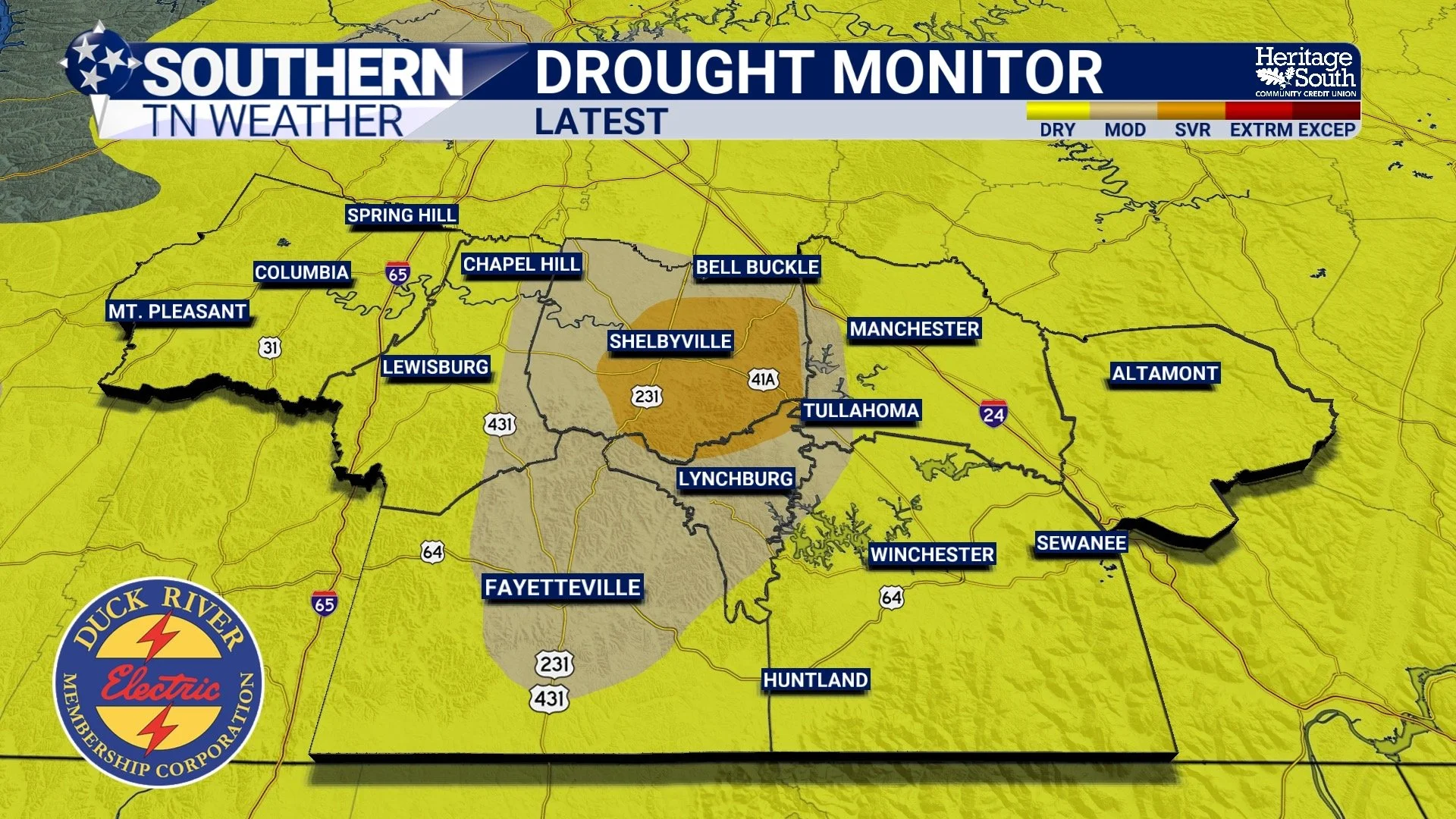
Severe Drought, or D2, has now entered portions of Bedford County, while Moderate Drought and Abnormally Dry conditions continue across other portions of the area. That’s another step in the wrong direction after several weeks of increasingly dry weather, and unfortunately, the ridiculous September heat we’ve experienced this week isn’t helping matters.
We’ve spent much of the week with temperatures in the middle and upper 90s, very little rainfall and plenty of sunshine. Not only are we failing to add much water back into the ground, but extreme heat also increases the rate at which moisture is lost from soils and vegetation.
In other words, we’re making withdrawals from the moisture bank without making many deposits.
What Does Severe Drought Actually Mean?
The U.S. Drought Monitor uses five categories to describe increasing levels of dryness. D0, or Abnormally Dry, isn’t technically considered drought. Think of it more as an early warning that conditions are unusually dry or an area is recovering from drought. D1, or Moderate Drought, is the first actual drought category. From there we progress into D2 Severe Drought, D3 Extreme Drought and D4 Exceptional Drought.
So Bedford County entering D2 is significant, but it doesn’t mean every creek suddenly dries up or every farm immediately experiences major losses. Drought impacts can vary considerably even across relatively short distances. Instead, the designation tells us that multiple indicators are pointing toward a more established and significant moisture shortage.
As drought reaches this level, impacts can include increasing stress on pastures and crops, declining soil moisture, browning and stressed vegetation, and decreasing water availability in smaller streams and ponds.
And remember, the Drought Monitor isn’t created by simply looking at how much rain has fallen. Analysts consider a wide range of information, including precipitation deficits, soil moisture, streamflow, vegetation health, groundwater, temperature, drought indices and reports of actual impacts occurring on the ground.
That last part is especially important right now because heat can accelerate drought deterioration.
When temperatures remain unusually hot day after day, more water is lost from the ground through evaporation while vegetation continues losing moisture through transpiration. If we’re regularly getting rainfall to replace that moisture, that’s not necessarily a problem. But when rainfall becomes scarce, the moisture balance starts dropping pretty quickly.
Earlier wet weather gave us a decent amount of moisture to work with across Tennessee. Think of it as putting money into a savings account. But over the past several weeks, we’ve been making withdrawal after withdrawal through hot temperatures, sunshine and a lack of widespread rainfall.
This week’s heat wave certainly hasn’t helped. Temperatures have repeatedly reached the middle and upper 90s, with some locations approaching 100°. That’s around 10 degrees above normal in some areas. Add mostly sunny skies and almost no meaningful rainfall, and the landscape can dry surprisingly quickly.
The increasingly brown grass we’re seeing across Southern Middle Tennessee is one of the most obvious signs of that stress.
The Dryness Goes Well Beyond Southern Middle Tennessee
We’re certainly not alone in dealing with worsening drought. The latest national Drought Monitor update describes widespread deterioration across portions of the southern United States as exceptionally warm temperatures and limited rainfall continue.
Some locations farther west have experienced flash drought, which occurs when drought develops or intensifies unusually quickly because of a combination of factors such as extreme heat and a sudden lack of rainfall. Much of Texas and portions of the surrounding region have experienced particularly rapid deterioration recently.
At the same time, rainfall across the country has been extremely uneven. Portions of Iowa, Nebraska, Kansas and Missouri received significant rainfall during the past week, with more than four inches reported in some areas. Another corridor of substantial rainfall affected Ohio, West Virginia and western Pennsylvania, while portions of Florida and the Gulf Coast received two to four inches. Meanwhile, other areas received very little.
That’s actually a good reminder of something we’ve talked about several times recently: not all rain is created equal, and rainfall isn’t distributed evenly.
The same thing happens locally. One community can pick up an inch or two from a slow-moving thunderstorm while somewhere 10 miles down the road barely gets enough rain to wet the pavement. The lucky community gets some temporary relief, but that doesn’t necessarily provide the widespread moisture needed to reverse drought across an entire county or region.
And once we get into established drought, one good thunderstorm usually isn’t enough to fix everything anyway.
What would really help Southern Middle Tennessee is several rounds of widespread, manageable rainfall that soak into the ground over time. That allows moisture to replenish the upper layers of soil, helps vegetation recover and eventually begins addressing some of the deeper moisture deficits.
Fortunately, there are finally at least some signs of that kind of opportunity showing up in the forecast.
Could Next Week Finally Bring Some Help?
We’re going to have to endure several more days of serious heat first.
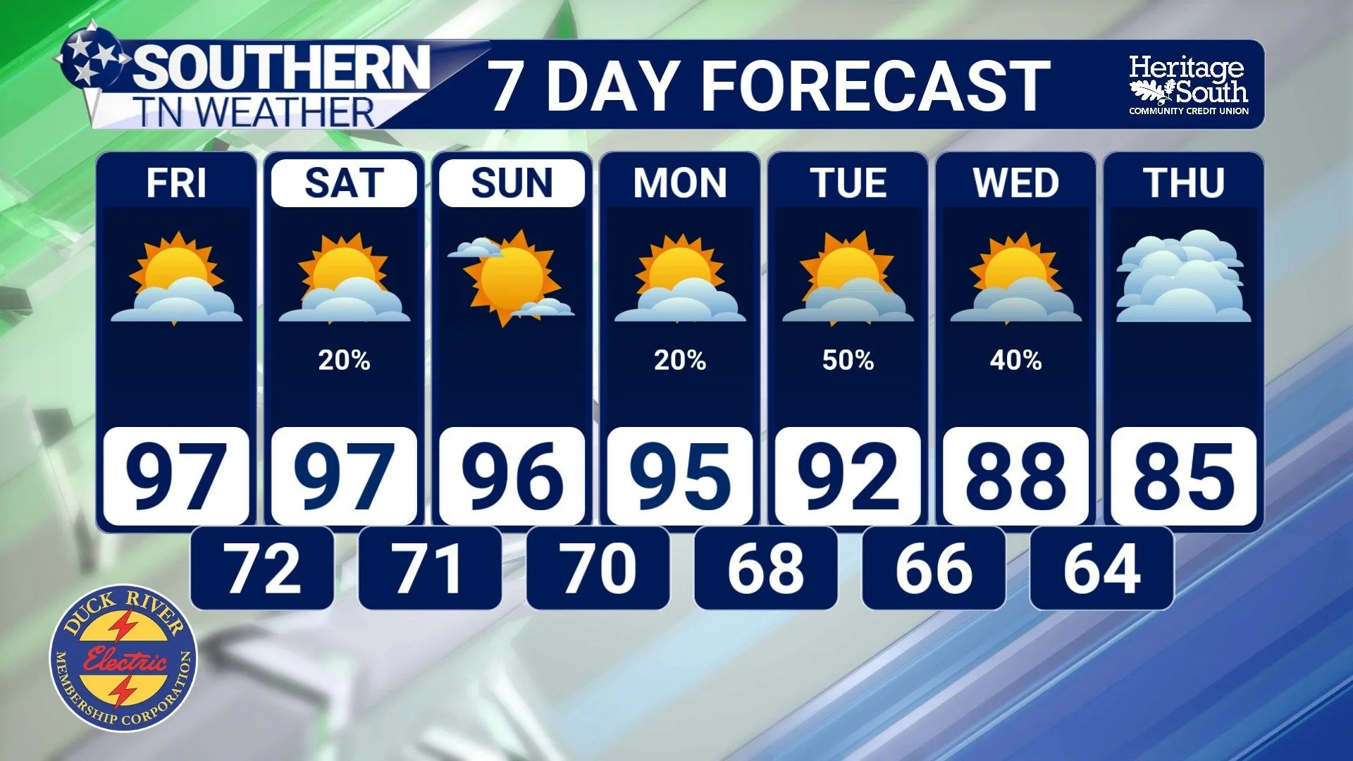
Temperatures this afternoon will once again climb into the middle and upper 90s, with some locations potentially flirting with 100°. Heat Index values could reach 105–108°, and a Heat Advisory remains in effect across the region through Saturday.
Friday and Saturday look very similar. Highs remain well into the 90s, and meaningful rainfall remains unlikely for most of Southern Middle Tennessee. A very isolated shower or thunderstorm can’t be completely ruled out, particularly closer to the Cumberland Plateau, but the overwhelming majority of us will probably remain dry.
Even Sunday could remain quite hot, but we’re finally beginning to see the stubborn ridge of high pressure responsible for this heat loosen its grip.
As that ridge gradually retreats westward, the atmosphere should become more favorable for moisture and disturbances to return. Rain chances are currently expected to increase into roughly the 30–50% range early to mid next week, while temperatures finally begin backing away from the upper 90s. Highs could return to the upper 80s in many locations.
That’s certainly encouraging, especially considering how badly we need rain.
But I don’t want anyone looking at a 50% rain chance next week and assuming our drought problems are about to disappear.
A few thunderstorms won’t automatically erase several weeks of increasing dryness.
If next week’s pattern produces multiple rounds of widespread beneficial rainfall, we could certainly begin improving soil moisture and slowing the deterioration we’ve been seeing. How much improvement we actually get will depend on exactly where the rain falls, how widespread it becomes, how much we receive and whether additional rainfall opportunities continue afterward.
Think back to our moisture savings account. We’ve been making withdrawals for several weeks… One good deposit helps. But we’re going to need more than one deposit to rebuild the balance!
The Bottom Line 🧾
🟠 Severe Drought (D2) has now entered portions of Bedford County.
🌾 Moderate Drought and Abnormally Dry conditions continue across other portions of Southern Middle Tennessee.
🌡️ Persistent extreme heat is accelerating moisture loss from soils and vegetation.
☀️ Meaningful rainfall remains unlikely through most of the weekend.
🥵 A Heat Advisory continues through Saturday, with Heat Index values potentially reaching 105–108°.
🌧️ Rain chances should increase into the 30–50% range early to mid next week.
📉 Temperatures should finally begin trending downward, with highs potentially returning to the upper 80s.
💧 Several rounds of widespread, manageable rainfall would be much more beneficial than isolated heavy thunderstorms.
⚠️ Even if rain returns next week, one round won’t necessarily erase several weeks of worsening drought.
📰 Reminder: The Southern Tennessee Weather Blog, presented by Heritage South Community Credit Union, is updated Monday through Friday with fresh, locally tailored forecasts you can trust.
