
Weekend Forecast: Summer Starts Turning Up the Heat Again

The Southern Tennessee Weather Blog is proudly presented by Heritage South Community Credit Union.
We Help When Others Won’t!
Visit https://www.heritagesouth.org/ today to see how HSCCU can help YOU!
If you've got outdoor plans this weekend, I've got some pretty good news. Overall, the weather across Southern Middle Tennessee looks GREAT! We're heading into a very quiet stretch with plenty of sunshine, very little chance for rain and humidity that should remain fairly manageable through much of the weekend. Saturday, in particular, looks like one of those late-August days where it's certainly warm, but it shouldn't feel nearly as oppressive as some of the heat we've dealt with this month.
There is, however, a catch. The weather pattern responsible for our recent stretch of somewhat more comfortable conditions is beginning to change. Temperatures will start climbing this weekend, and by the time we get into next week, another significant stretch of summer heat will be settling across the region. Apparently September didn't get the memo that fall is supposed to be getting closer.
Saturday Looks Pretty Nice
A weak trough that has helped keep temperatures closer to normal will continue shifting east, while a large ridge of high pressure over the western United States begins expanding toward the Tennessee Valley. Saturday essentially marks the beginning of that transition.
We'll see plenty of sunshine with temperatures climbing a few degrees compared to Friday. Most locations should reach the upper 80s to lower 90s, but the good news is that humidity remains relatively tolerable. Dewpoints should generally remain in the 60s, keeping heat index values from getting out of hand. Rain chances are practically nonexistent for most of Southern Middle Tennessee. I can't completely rule out a tiny pop-up shower around the Cumberland Plateau, but probabilities are generally below 10%. If you're headed to a football game, the Tennessee Walking Horse National Celebration, working in the yard or doing just about anything else outdoors Saturday, the weather should cooperate.
One minor issue will be fog. Patchy fog will be possible again late tonight into early Saturday morning, particularly in valleys and the usual low-lying locations. Once that burns away, we're looking at a pretty straightforward summer day.
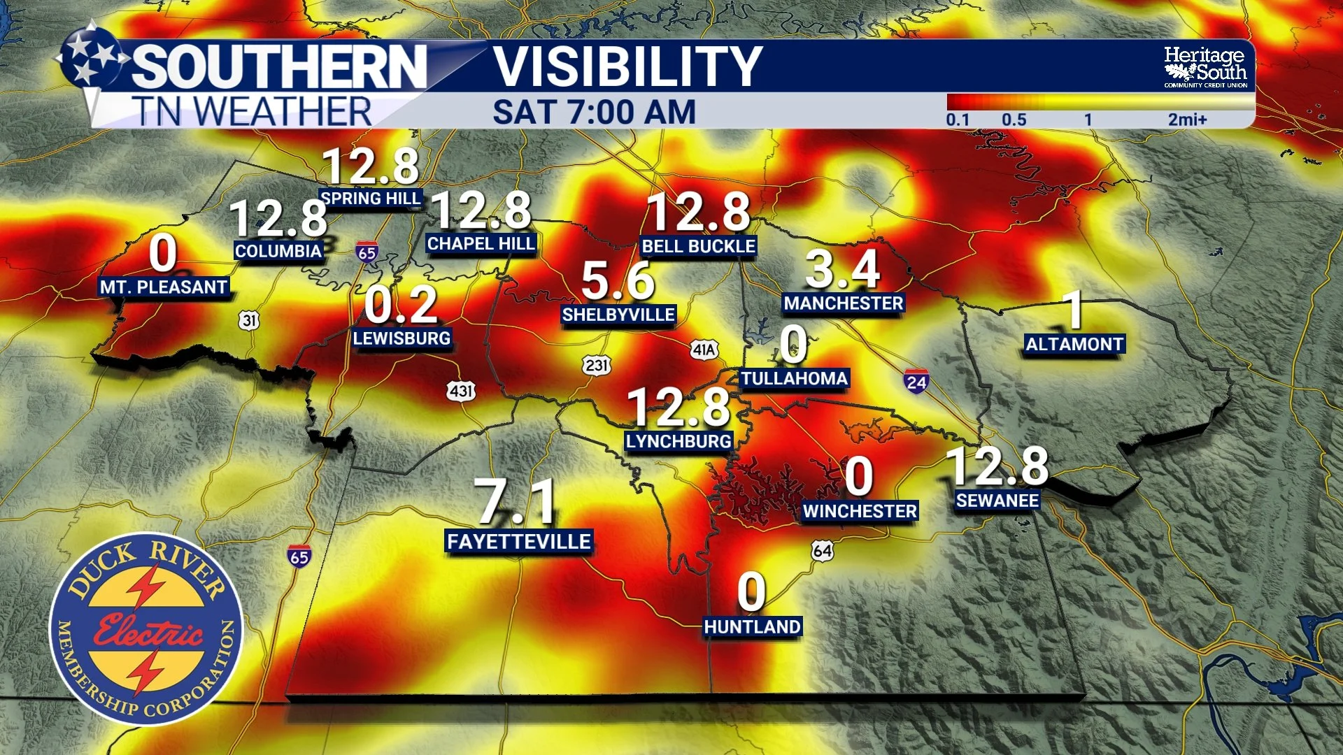
FUTURECAST VISIBILITY - SATURDAY MORNING
Sunday IS MORE OF THE SAME
By Sunday, we'll begin feeling the effects of that expanding ridge a little more. Temperatures should climb into the lower to middle 90s, while moisture gradually starts returning to the region. That means Sunday will likely feel noticeably hotter than Saturday, with heat index values beginning to approach 100° in some locations. There could also be a very isolated afternoon shower or thunderstorm, particularly across eastern portions of the area and around the Plateau. However, this is NOT shaping up to be a rainy Sunday. Most locations should remain completely dry.
The bigger story is really the beginning of our warming trend. As the ridge expands eastward, sinking air underneath it will suppress widespread cloud and thunderstorm development. Combine that with plenty of late-August sunshine, and temperatures will have very little standing in their way. And unfortunately, that ridge isn't going anywhere quickly.
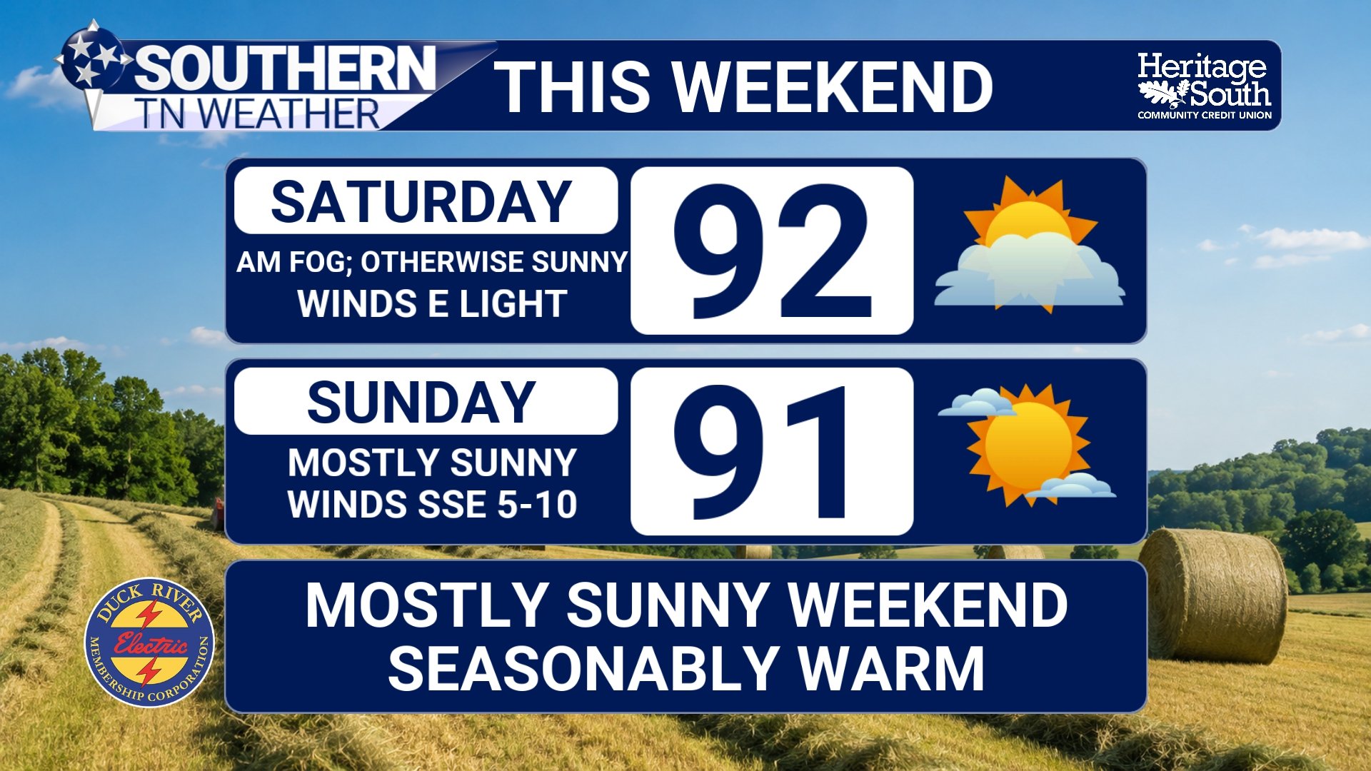
WEEKEND FORECAST
Next Week Is Where Things Really Heat Up
The weekend itself shouldn't be too bad. It's next week that gets my attention. Upper-level high pressure is expected to become firmly established across the Southeast, allowing temperatures to climb through the middle 90s early in the week. By the middle and latter portions of next week, highs could reach the upper 90s across a good portion of Southern Middle Tennessee. That's significant heat anytime, but it'll be especially noticeable considering we'll officially be moving into September.
Humidity will also gradually increase. Forecast guidance currently suggests heat index values around 100-105° could become common next week, with the possibility of even higher values if dewpoints trend upward more than currently expected. That's the part of the forecast we'll have to watch closely. Actual temperatures in the upper 90s are plenty hot by themselves, but adding higher humidity can quickly turn a hot afternoon into one with more significant heat impacts. Heat advisories aren't a guarantee at this point, but if current trends continue, they could eventually become necessary somewhere across the Tennessee Valley by the middle of next week.
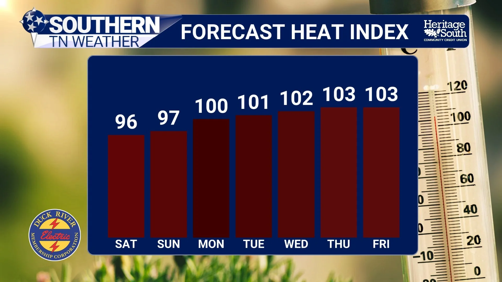
FORECAST HEAT INDEX VALUES
Don't Expect Much Rain, Either
Unfortunately, there isn't much relief coming from afternoon thunderstorms. The strengthening ridge will create widespread sinking air across the region, which makes it considerably more difficult for thunderstorms to develop. There could still be an isolated pop-up storm here or there, especially around the Cumberland Plateau, but organized or widespread rainfall isn't showing up through next week.
For many communities, that could mean several consecutive days without measurable rainfall while temperatures continue climbing. So while we're entering September next week, the atmosphere is going to look and feel much more like the middle of summer. We WILL eventually get to cooler mornings, lower humidity, football weather, changing leaves and pumpkin-spice-everything season… Next week just isn't it. 😂
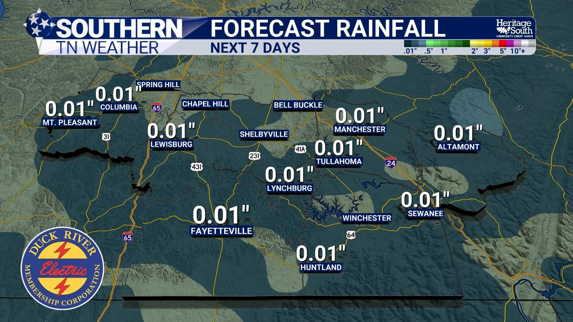
FORECAST RAINFALL - NEXT 7 DAYS
The Bottom Line 🧾
🌤️ Saturday: Mostly sunny and dry with highs in the upper 80s to lower 90s. Humidity remains fairly manageable.
🌫️ Morning fog: Patchy fog is possible again late tonight into Saturday morning, especially in valleys and low-lying areas.
☀️ Sunday: Mostly dry and hotter, with highs climbing into the lower to middle 90s.
🌡️ Humidity: Still reasonable Saturday before gradually increasing Sunday and into next week.
🥵 Next week: Another significant warm-up arrives with highs reaching the middle 90s and potentially upper 90s by mid-to-late week.
🔥 Heat index: Values around 100-105° could become common as humidity increases.
🌧️ Rain chances: Very low overall, with only isolated afternoon activity possible, favoring the Cumberland Plateau.
🍂 September begins Tuesday: Unfortunately, Mother Nature appears to have absolutely no interest in participating.
📰 Reminder: The Southern Tennessee Weather Blog, presented by Heritage South Community Credit Union, is updated Monday through Friday with fresh, locally tailored forecasts you can trust.
