
Another Heat Wave on The Horizon!

The Southern Tennessee Weather Blog is proudly presented by Heritage South Community Credit Union.
We Help When Others Won’t!
Visit https://www.heritagesouth.org/ today to see how HSCCU can help YOU!
I hope everyone enjoyed our little break from the worst of the summer heat, because Mother Nature is apparently ready to turn the thermostat back up. After several days of relatively seasonable late-August temperatures, the large-scale weather pattern is getting ready to change again. An upper-level ridge of high pressure currently centered farther west will gradually expand eastward over the next several days. As it does, our temperatures will begin a steady climb through the weekend and into next week.
By the time September arrives, middle and potentially upper 90s will be back on the table across Southern Middle Tennessee, and increasing humidity could push heat index values back into the triple digits. Even more noticeable may be what's missing from the forecast: rain.
First, We Have a Few Storms to Get Through Today
Before the hotter and drier pattern takes over, we still have one more opportunity for scattered showers and thunderstorms this afternoon and evening. A weak surface boundary will slide southeastward through the region today, providing enough lift for scattered storms to develop along and ahead of it. This doesn't look quite as organized as the storms we dealt with Wednesday, and widespread severe weather is not expected.
Still, any summertime thunderstorm can briefly become feisty. The best opportunity for a stronger storm should generally be around the Cumberland Plateau, where an isolated storm could produce strong wind gusts along with heavy rainfall and frequent lightning. Farther west, scattered development will still be possible, but not everyone will receive rain. Whatever develops should gradually fade this evening as we lose daytime heating. Behind the boundary, slightly cooler and noticeably drier air begins filtering into Southern Middle Tennessee tonight and Friday.
Friday and Saturday Should Actually Feel Pretty Good
Before you see the words "heat wave" and start throwing things at me, there is some good news. Friday should be a pretty nice late-August day. Highs will generally reach the upper 80s to around 90° with lower dewpoints filtering into the region. Those dewpoints should fall into the 60s, meaning the humidity will be noticeably more manageable than it has been during some of our recent stretches of heat. The atmosphere also dries considerably, and widespread afternoon thunderstorm development is not expected.
Saturday begins our warming trend, but it shouldn't be anything outrageous just yet. Temperatures gradually climb as upper-level ridging starts building eastward, while dewpoints remain relatively tolerable. So if you've got outdoor plans this weekend, Saturday in particular doesn't look bad at all for late August. Then we turn up the thermostat…
Why Is Another Heat Wave Developing?
The culprit is something we've talked about several times this summer: upper-level high pressure (or ridge). By Sunday and especially into next week, a strong ridge is expected to become increasingly established across the southern United States. Think of this ridge as a large dome in the atmosphere. Air underneath a ridge generally sinks. As that air descends, it compresses and warms. Sinking air also makes it more difficult for clouds and thunderstorms to develop, which allows more sunshine to reach the ground.
More sunshine leads to more heating. More heating strengthens the hot air mass underneath the ridge. And without widespread thunderstorms around to provide clouds or rain-cooled air, there isn't much to interrupt the process. That's why strong summertime ridges can produce several consecutive days of hot, mostly sunny weather. In our case, temperatures should begin climbing through the lower 90s this weekend before reaching the middle 90s during the first half of next week. Some guidance suggests upper 90s could eventually become possible depending on exactly where the ridge establishes itself and how strong it becomes.
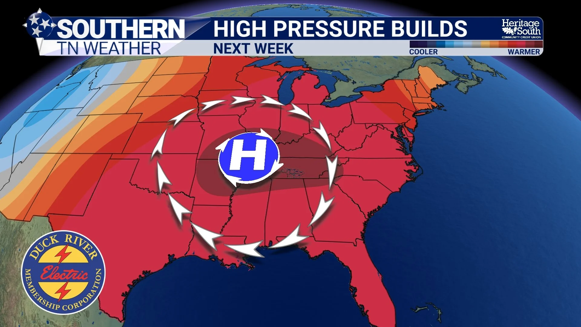
HIGH PRESSURE BUILDS
The Humidity Will Be Important
There's an important difference between this upcoming stretch of heat and some of the brutal heat we experienced earlier this month. Dewpoints currently don't look quite as extreme. Earlier August heat waves featured temperatures in the middle and upper 90s combined with dewpoints frequently well into the 70s. That combination sent heat index values into the 105-110° range and, in some cases, even higher.
This time around, forecast guidance suggests somewhat better mixing of drier air could keep dewpoints lower, particularly through the weekend. That's good news—but only to a point. As moisture begins returning early next week, afternoon heat index values could climb into the 100-107° range, particularly if actual air temperatures reach the middle or upper 90s.
Exactly how humid we become will make a HUGE difference in how serious the heat ultimately gets. A 97° afternoon with a dewpoint in the middle 60s is a very different experience from 97° with a dewpoint in the middle 70s. That's something we'll be watching closely over the next several days.
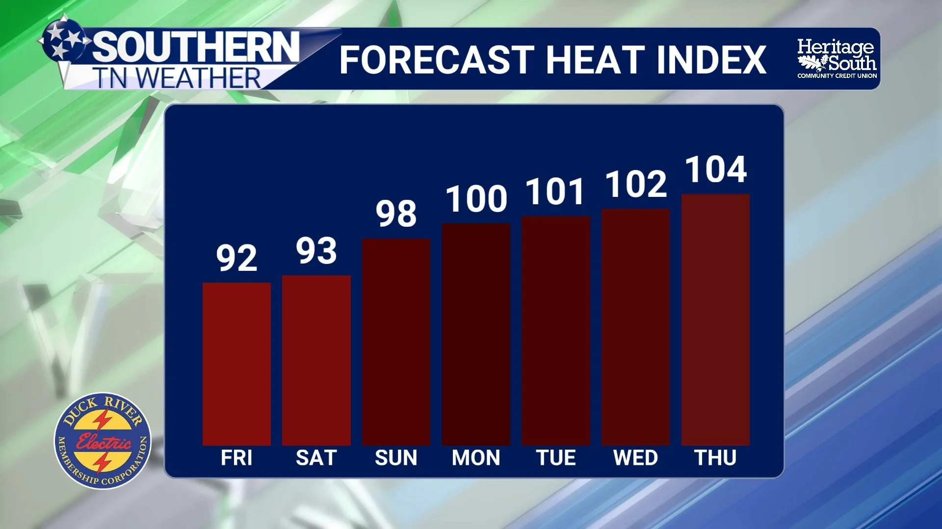
HEAT INDEX FORECAST
And There Isn't Much Rain in Sight
Perhaps the bigger story with this pattern isn't simply the heat. It's the combination of heat AND very limited rainfall. Once today's boundary moves through, there aren't any organized rainmakers showing up in our extended forecast. High pressure produces sinking air, which suppresses the rising motion necessary for showers and thunderstorms. Could somebody manage to squeeze out a random afternoon pop-up next week? Sure. It's summertime in Tennessee, so I'll never completely rule that out this far in advance.
But probabilities remain very low, generally below 20%, and there currently isn't a widespread soaking rain anywhere in sight. That means lawns, gardens and agricultural areas that miss today's rainfall could continue drying out as sunshine, hot temperatures and increased evaporation take over.
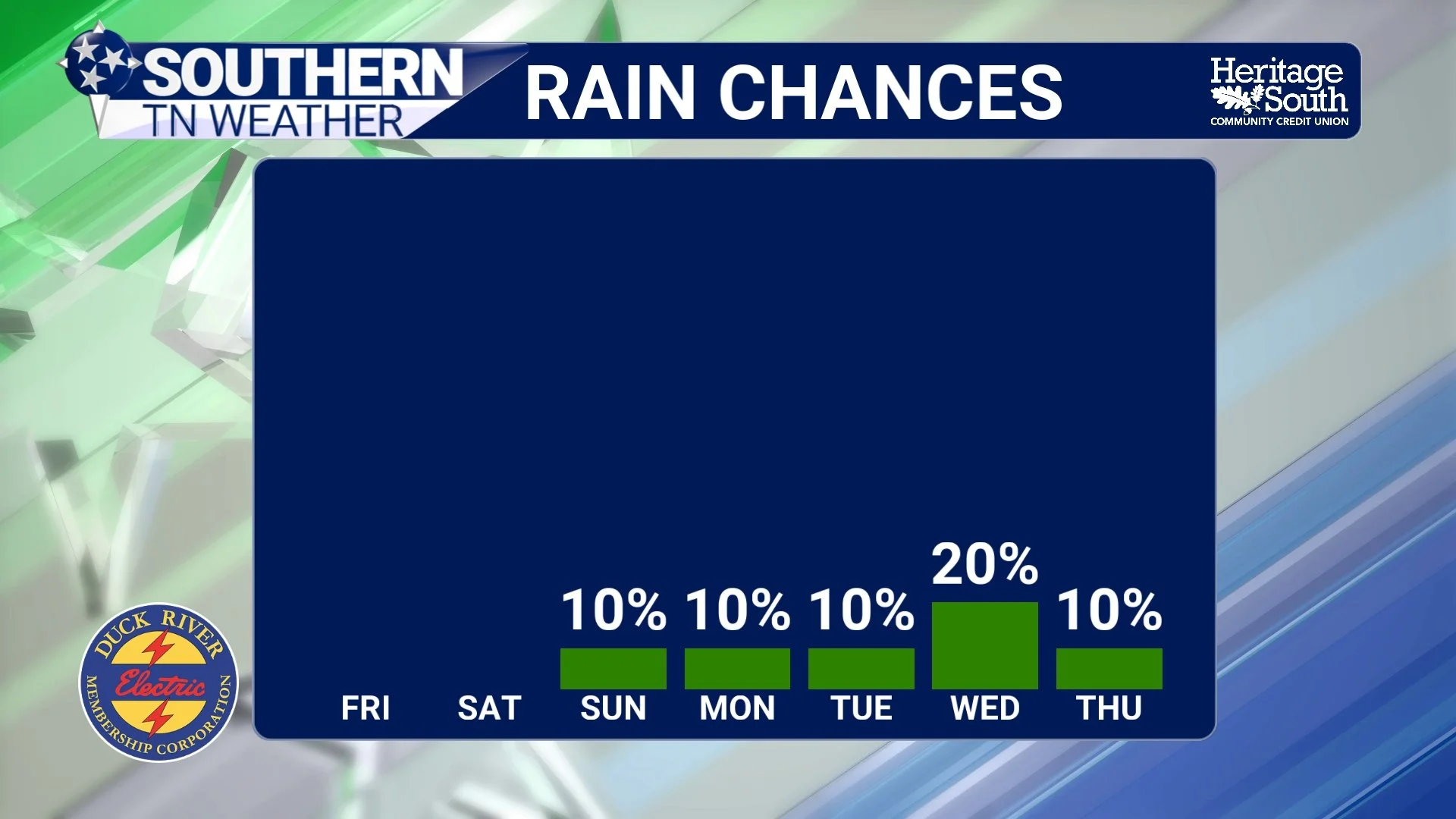
RAIN CHANCES
This Isn't Just Showing Up in Our Local Forecast
The larger-scale outlook from NOAA's Climate Prediction Center backs up the idea that significant heat could continue into early September. The CPC's latest 8-to-14-day outlook, valid September 3-9, favors above-normal temperatures across Tennessee. Its separate hazards outlook highlights a Slight Risk of extreme heat across portions of the Tennessee Valley from September 3-6, with a Moderate Risk extending into portions of the Tennessee Valley and Southeast on September 3. That doesn't mean Southern Middle Tennessee is guaranteed to reach a certain temperature or heat index. These longer-range outlooks describe where conditions are unusually favorable for heat compared with what's normal for the time of year.
And that's important because we're entering September. Our normal temperatures gradually begin falling as daylight continues getting shorter. So temperatures reaching the middle and upper 90s become increasingly abnormal the farther we move away from the heart of summer. There is also some uncertainty about how long this hotter pattern lasts. The CPC notes growing disagreement between major ensemble systems about the evolution of the ridge and approaching troughs later in the period. In other words, confidence is pretty good that we're heating up, but confidence decreases regarding exactly when the pattern eventually breaks down.
Don't Put Summer Away Just Yet
We've spent this week talking about average first freezes, first snow and even Thursday night's lunar eclipse. Apparently summer felt left out. There's no indication of fall weather arriving anytime soon. Instead, the transition from August into September looks increasingly likely to feature another extended period of above-normal temperatures.
The good news is that this heat wave currently doesn't look identical to our worst stretch earlier this month because dewpoints could remain somewhat lower. But with several consecutive hot days, very little rainfall and the possibility of triple-digit heat indices returning, this is still something we'll need to take seriously. Enjoy the somewhat more comfortable weather Friday and Saturday. The furnace starts warming back up after that!
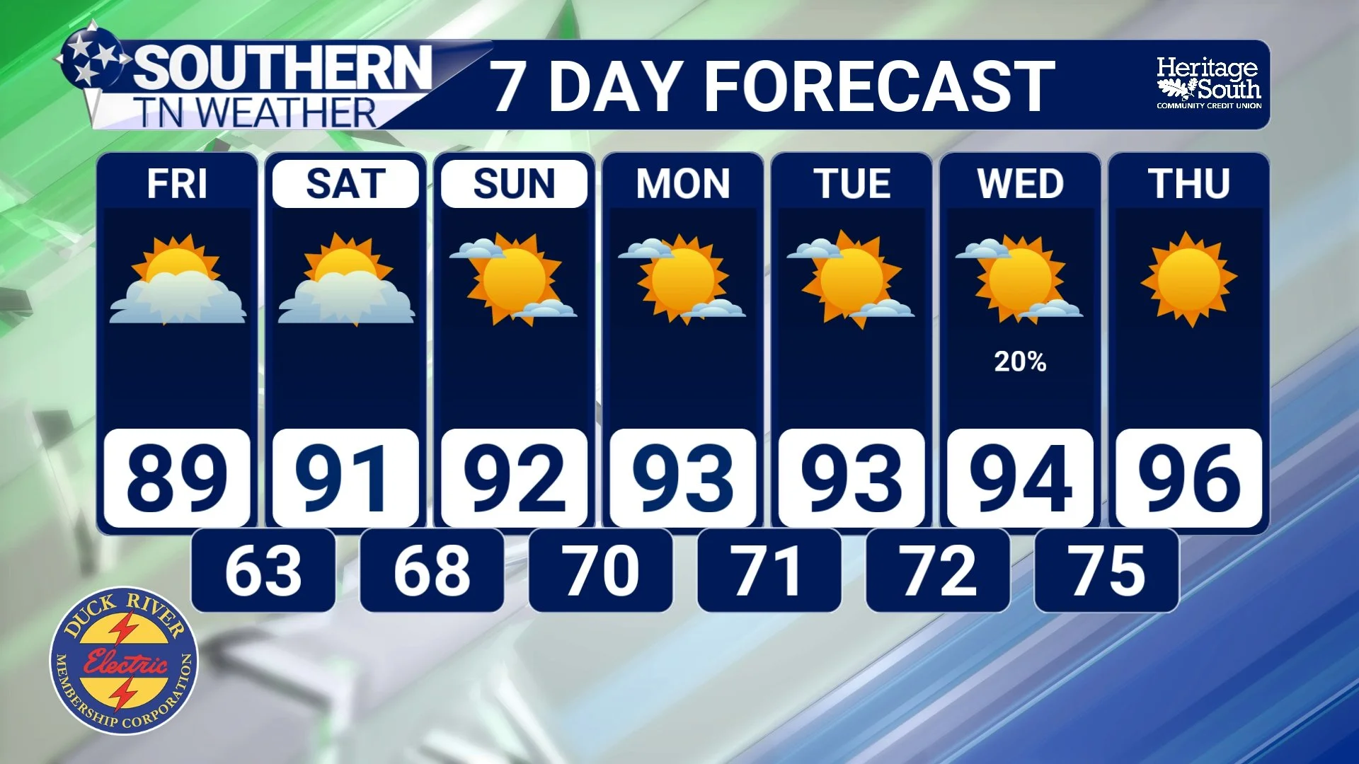
STNWX 7-DAY FORECAST
The Bottom Line 🧾
⛈️ Today: Scattered showers and thunderstorms remain possible this afternoon and evening. A stronger storm could produce gusty winds, especially around the Cumberland Plateau.
🌤️ Friday: Drier air arrives with highs around the upper 80s to near 90° and noticeably lower humidity.
☀️ Weekend: Mainly dry with temperatures beginning to climb, reaching the lower to middle 90s by Sunday.
🥵 Next week: Highs climb into the middle 90s, with upper 90s potentially possible depending on the strength and placement of the ridge.
🌡️ Heat index: Increasing humidity could eventually push afternoon heat indices into the 100-107° range.
🏜️ Very little rain: No organized rainmaker is currently showing up in the extended forecast, with rain chances generally below 20%.
🔥 Early September: The Climate Prediction Center continues to highlight an elevated risk for unusual heat across portions of the Tennessee Valley and Southeast.
📰 Reminder: The Southern Tennessee Weather Blog, presented by Heritage South Community Credit Union, is updated Monday through Friday with fresh, locally tailored forecasts you can trust.
