
Meteorological Fall Starts Tomorrow... So Where Is Fall?!

The Southern Tennessee Weather Blog is proudly presented by Heritage South Community Credit Union.
We Help When Others Won’t!
Visit https://www.heritagesouth.org/ today to see how HSCCU can help YOU!
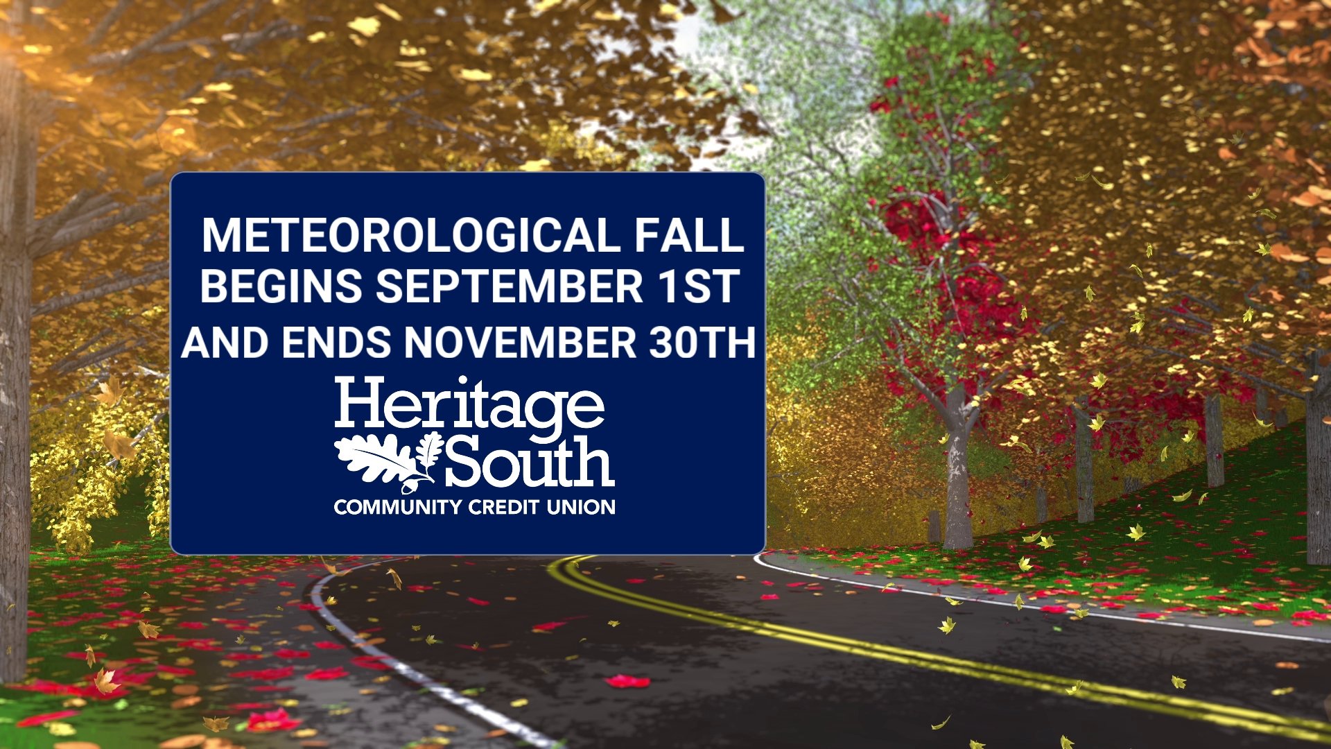
Tomorrow is September 1st. Pumpkin spice is everywhere, football is back, the days are getting shorter, and meteorologists will officially turn the calendar from summer to fall. Meanwhile, Mother Nature looked at the calendar and said, “That’s cute.” 😂
Instead of crisp mornings and comfortable afternoons, Southern Middle Tennessee is heading into one of the hottest stretches we’ve seen in a while. Highs will climb into the middle and upper 90s this week, humidity will make it feel even hotter, and Wednesday and Thursday could bring some of our most impactful heat of the week. So how in the world can meteorological fall begin tomorrow when it still feels like the middle of July? The answer is actually pretty simple: meteorological seasons aren’t determined by what the weather happens to feel like outside.
So What Exactly Is Meteorological Fall?
Most of us probably learned that fall begins around September 22 or 23. That’s astronomical fall, with the autumnal equinox determined by Earth’s position relative to the Sun. Meteorologists do things a little differently. For weather and climate records, we divide the year into four neat three-month seasons: winter is December through February, spring is March through May, summer is June through August, and fall is September through November.
That means meteorological fall begins on September 1 every single year. The reason is mostly practical. Using complete calendar months makes it much easier to compare temperatures, rainfall and other climate statistics from one year to another. If we want to compare summer 2026 with previous summers, for example, we can simply compare June, July and August without having to split portions of different months. But meteorological fall definitely does NOT mean someone flips the fall-weather switch at midnight tonight. September is very much a transition month in Tennessee, and sometimes that transition takes its sweet time. Daylight is decreasing rapidly by this point in the year, and the Sun is gradually getting lower in the sky, but the atmosphere doesn’t immediately forget about summer. The land and atmosphere have spent months warming, and it takes time for the seasonal temperature cycle to respond to our decreasing sunlight.
This delayed response is known as seasonal lag, and we see it on the other side of summer too. The longest day of the year occurs around June 21, yet our hottest average temperatures generally don’t arrive until several weeks later in July. In much the same way, losing daylight in August and September doesn’t immediately translate into crisp fall afternoons. And then there’s the weather pattern itself. The atmosphere doesn’t own a calendar, and if the large-scale setup favors heat, September is perfectly capable of behaving like August.
This Week Is a Perfect Example
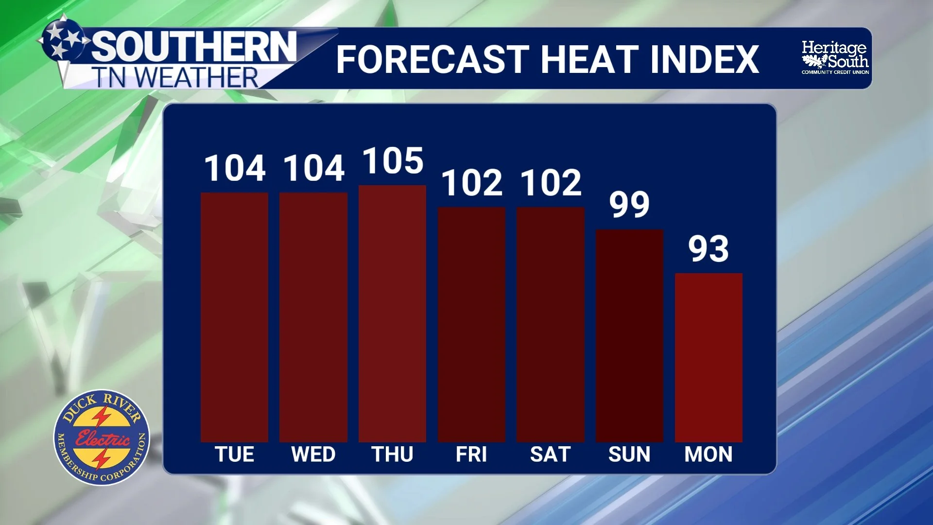
A strong upper-level ridge is strengthening across the eastern half of the United States, and that ridge will be the driving force behind our weather through much of this week. Beneath strong high pressure, air tends to sink through the atmosphere. As that air sinks, it compresses and warms while also making it more difficult for clouds, showers and thunderstorms to develop. The result is a pretty classic summertime setup: lots of sunshine, very little rain and plenty of heat. Temperatures across Southern Middle Tennessee will generally climb into the middle and upper 90s west of the Cumberland Plateau this week. Unfortunately, the humidity will be tagging along for the ride. Dewpoints in the upper 60s and lower 70s combined with those temperatures will push afternoon heat index values into the 100-106° range across portions of the Tennessee Valley.
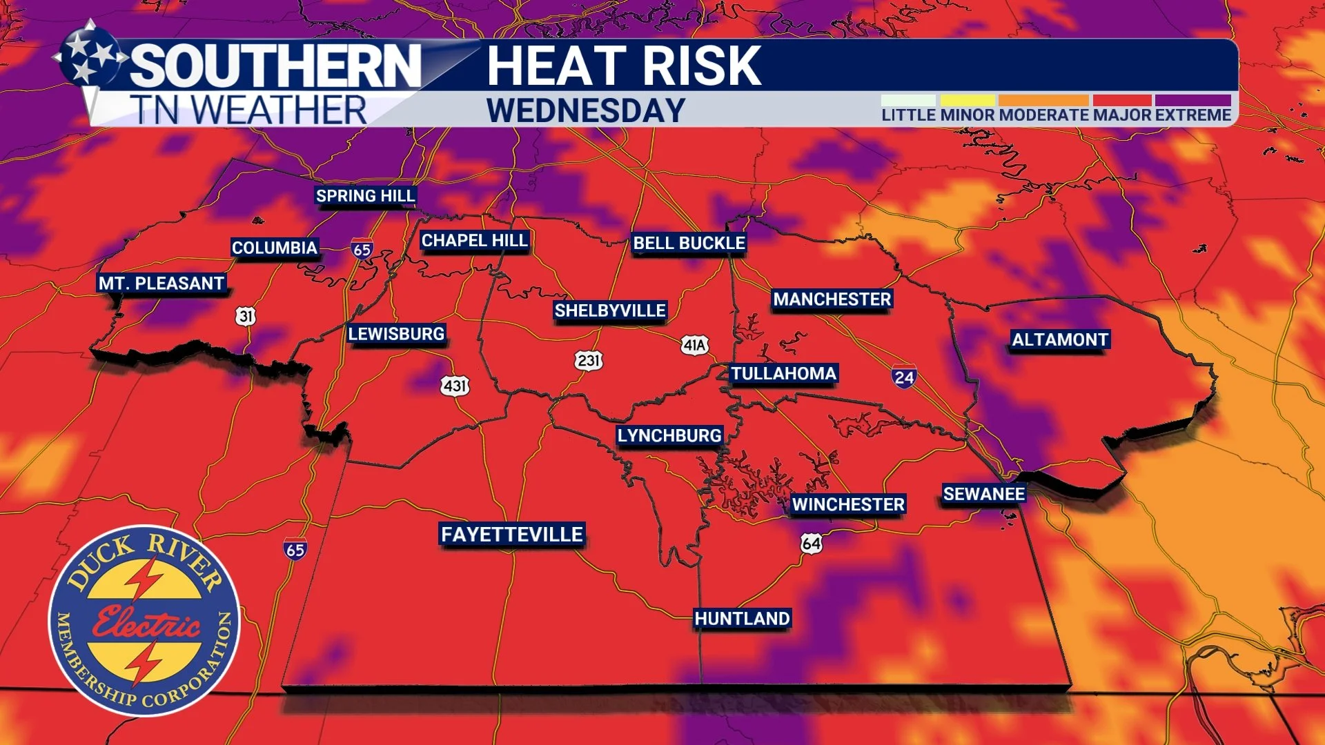
Wednesday and Thursday currently look like the most impactful days. The National Weather Service expects HeatRisk levels to climb into the Major category across many locations by Wednesday, with Major to locally Extreme HeatRisk possible across portions of Middle Tennessee during the peak of the heat.
That’s worth taking seriously even if we don’t technically reach Heat Advisory criteria everywhere. Several consecutive hot afternoons combined with warm nights can put additional stress on the body, particularly for people working outdoors, participating in sports or spending extended periods without adequate cooling. Drink plenty of water, take frequent breaks in the shade or air conditioning, and never leave children or pets inside a parked vehicle. There is at least a little interesting historical context to the heat. Nashville’s record high for Wednesday’s date is 99°, set in 2011. Current forecasts don’t necessarily suggest widespread records will fall, but temperatures may get close in spots. That's a pretty good reminder that turning the calendar to September doesn't suddenly make upper 90s impossible.
Hot, Dry and Not Much Relief From Rain
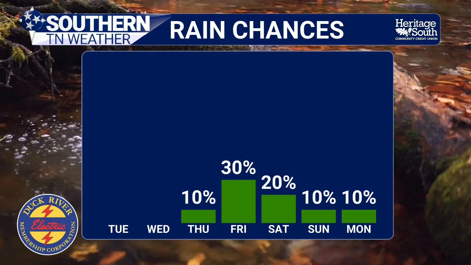
The same ridge responsible for the heat will also make meaningful rainfall very difficult to find. Rain chances remain extremely low through the middle of the week, although I can’t completely rule out a tiny afternoon pop-up shower or thunderstorm around the Cumberland Plateau. For the overwhelming majority of us, however, the forecast is simply hot, mostly sunny and dry. Without widespread thunderstorms around to produce clouds or rain-cooled air, there won't be much to interrupt the daytime heating process.
There are signs that the ridge may finally begin weakening and shifting westward toward the end of the week. Friday still looks hot and humid, but the overall heat risk should begin easing somewhat. Heading into Labor Day weekend, temperatures may back off a little more as the ridge loosens its grip, although afternoon highs will probably remain somewhat above normal. And, naturally, there's a trade-off. As high pressure weakens, the atmosphere becomes more favorable for our classic summertime pop-up thunderstorms to return. Low to medium rain chances could creep back into the forecast this weekend, although nothing currently suggests an organized widespread rain event.
Forecast confidence decreases a little more by Sunday and Labor Day as computer models wrestle with a potential cold front. If that front successfully pushes through the region, highs could finally fall closer to the lower 90s. If it stalls or falls apart before getting here, the hotter pattern could hang around longer. We'll have a much better idea as we get closer.
Fall Will Get Here... Eventually
There's really no single date when Southern Middle Tennessee suddenly starts “feeling like fall.” Our average temperatures steadily decline through September, and progressively stronger pushes of cooler and drier air become possible as we move deeper into the month. Eventually we'll get that first morning when you walk outside, feel the lower humidity and think, “Okay... THAT feels different.” Then it'll probably warm back up three days later, because this is Tennessee. 😂
September and October are transition months, and our weather frequently bounces between summer and fall before cooler conditions finally win the battle. Meteorological fall is simply a convenient way for meteorologists and climatologists to organize the seasons. Mother Nature is under absolutely no obligation to follow it. So yes, meteorological fall officially begins tomorrow and you're absolutely allowed to put out the pumpkins. You might just want to do it in the air conditioning…
The Bottom Line 🧾
🍂 Meteorological fall begins September 1 and includes September, October and November.
☀️ Astronomical fall begins later in September and is based on Earth’s position relative to the Sun.
🌡️ September 1 doesn't guarantee fall weather. Seasonal lag and the overall atmospheric pattern can keep summer heat going well into September.
🔥 This week is a perfect example: Highs climb into the middle and upper 90s across much of Southern Middle Tennessee.
🥵 Wednesday and Thursday look hottest, with heat index values potentially reaching 100-106° and Major to locally Extreme HeatRisk.
☀️ Rain chances remain extremely low through midweek as strong high pressure suppresses widespread thunderstorm development.
⛈️ Labor Day weekend: The ridge may weaken, allowing temperatures to ease somewhat while isolated to scattered summertime storms return.
🎃 Yes, meteorological fall starts tomorrow. No, Mother Nature apparently does not care.
📰 Reminder: The Southern Tennessee Weather Blog, presented by Heritage South Community Credit Union, is updated Monday through Friday with fresh, locally tailored forecasts you can trust.
