
Weekend Forecast: Saturday Headlines With Storms, Sunday Improves

The Southern Tennessee Weather Blog is proudly presented by Heritage South Community Credit Union.
We Help When Others Won’t!
Visit https://www.heritagesouth.org/ today to see how HSCCU can help YOU!
If you're making weekend plans, Saturday is the day you'll want to keep a close eye on the forecast. Whether it's a ballgame, a cookout, a trip to the lake, or simply mowing the yard, you'll want to have a backup plan ready. While the entire weekend won't be a washout, Saturday is expected to bring the highest coverage of showers and thunderstorms we've seen in several days.
The severe weather threat remains on the lower end, but it isn't zero. A few storms could become strong enough to produce damaging wind gusts Saturday afternoon and evening, while locally heavy rainfall could lead to isolated flooding in a few spots. The good news? Sunday's forecast is already looking better.
Friday Ends On A Quiet Note
Today is another winner across Southern Middle Tennessee. Humidity remains comfortably low, afternoon temperatures will top out in the upper 80s, and sunshine will dominate for much of the day. It won't stay this way forever, though. Clouds will gradually increase tonight as our next weather system approaches from the Midwest.
Most communities should remain dry through much of the evening before showers begin developing late tonight into the early morning hours.
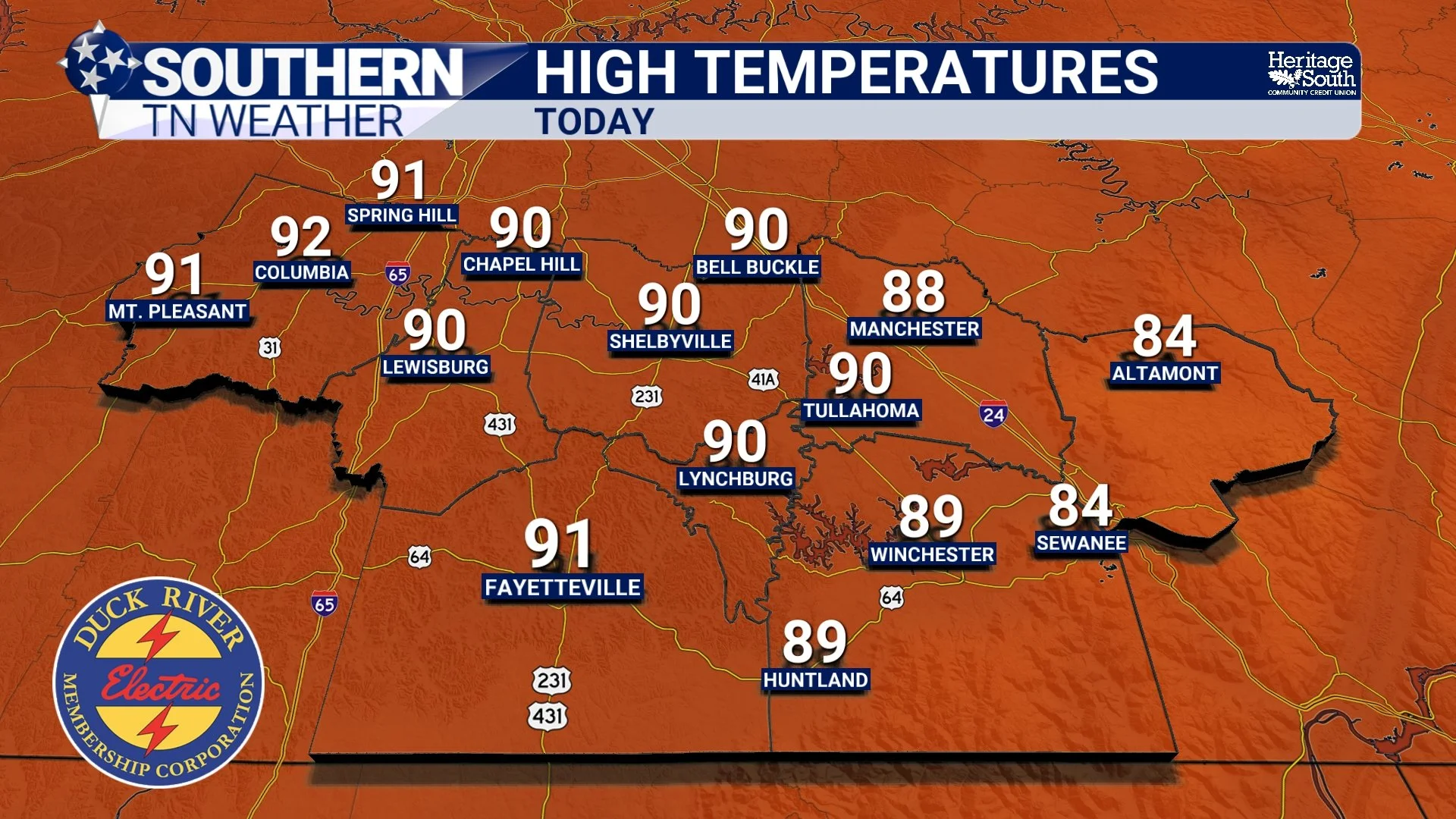
HIGH TEMPS - TODAY
Round One: Early Saturday Morning
The first round of showers and thunderstorms is expected to arrive between 4 AM and 10 AM Saturday. This morning activity is not expected to be severe, but it will produce periods of moderate to heavy rainfall, frequent lightning, and a few rumbles of thunder. It doesn't mean it will rain continuously during that six-hour window at your location, but that's when the greatest coverage of rain is expected across Southern Middle Tennessee.
As the morning rain moves away, many locations should catch a break around midday. Some communities may even see a little sunshine, and that sunshine will help determine how active the afternoon becomes.
Round Two: Saturday Afternoon And Evening
Our greatest concern remains the second round of storms expected between roughly 3 PM and 10 PM. As a stronger cold front sweeps into the region during the warmest part of the day, scattered thunderstorms are expected to develop along and ahead of the boundary before moving east through the evening. Unlike the morning rain, this won't be one continuous line affecting everyone at the same time. Instead, storms should develop in scattered clusters, meaning some communities could experience multiple thunderstorms while others receive very little rain during the afternoon.
Any storm that develops, however, will have the potential to become strong.
Damaging Winds Are The Primary Threat
The Storm Prediction Center has upgraded most of Southern Middle Tennessee into a Slight Risk (Level 2 of 5) for severe thunderstorms. The primary hazard continues to be damaging straight-line wind gusts exceeding 60 MPH. There is also a little more low-level spin in the atmosphere than we've seen recently, so we'll continue watching for an isolated tornado. That said, the tornado threat remains very low and is not the primary concern with this system.
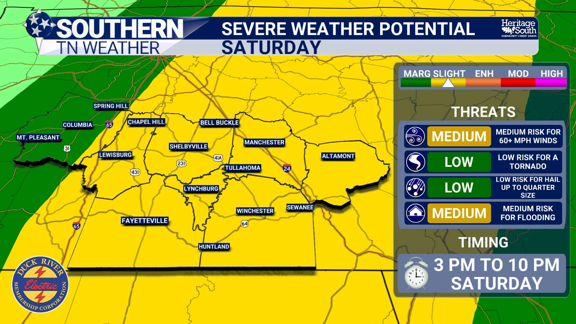
SEVERE THREAT - SATURDAY
Heavy Rainfall Could Cause Localized Flooding
In addition to the wind threat, thunderstorms will once again be capable of producing very heavy rainfall. Most communities should receive between one-quarter inch and one inch of rain, but localized totals of 2 to 3 inches will be possible where storms repeatedly move across the same locations. Widespread flooding is not expected, but localized flash flooding and water-covered roads could develop underneath the strongest storms Saturday afternoon and evening.
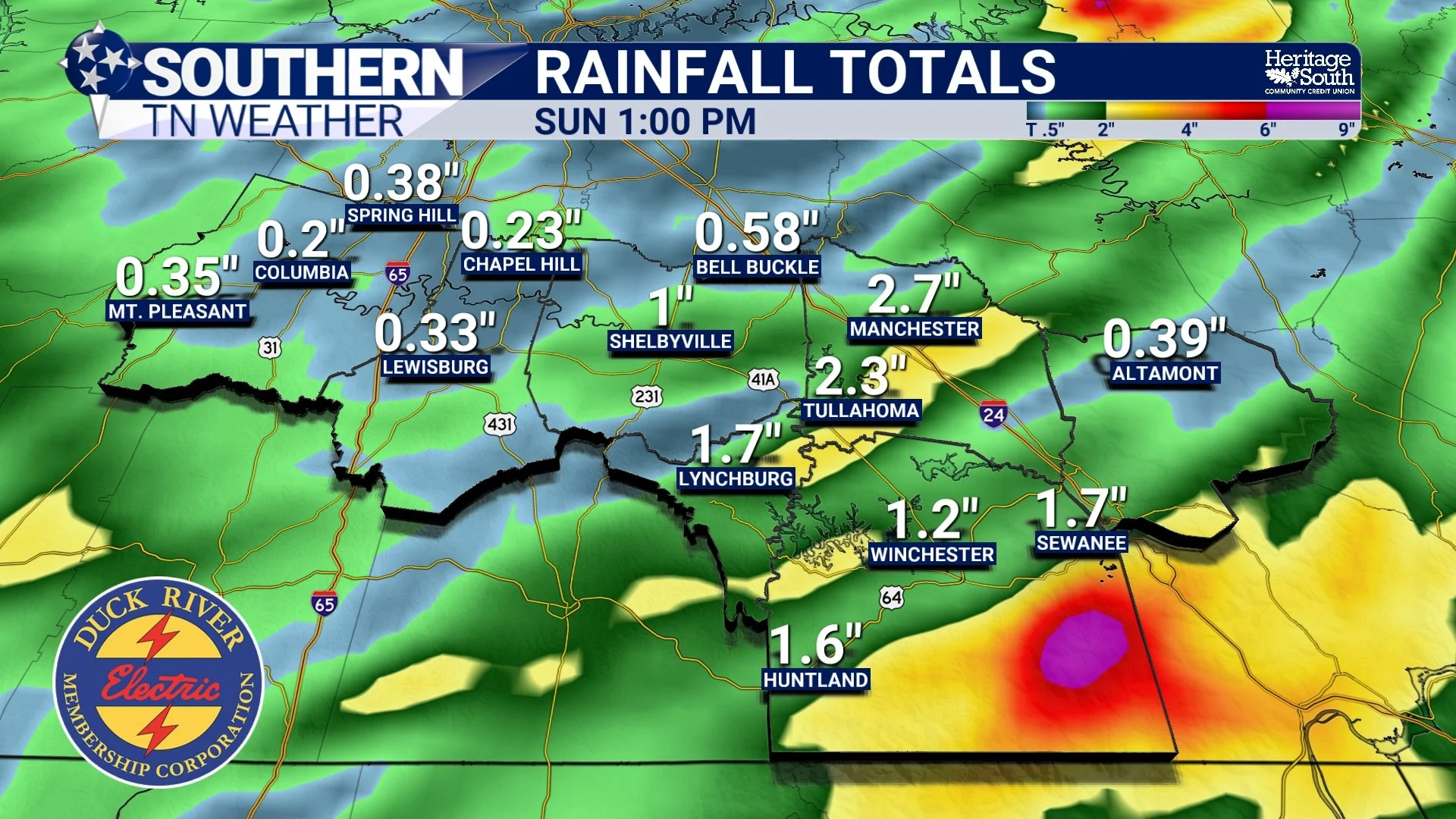
RAINFALL TOTALS - THRU SUNDAY
Sunday Won't Be Perfect, But It Will Be Better
The cold front won't clear the area immediately, so a few showers and thunderstorms may linger into Sunday. However, the overall severe weather threat drops off considerably after Saturday evening, and rain coverage should become much more scattered as the day goes on.
You'll also notice a more comfortable feel to the air returning. Afternoon temperatures will remain in the 80s, but humidity levels will once again be much lower than what we've experienced for much of July, making it a much nicer day to spend outdoors.
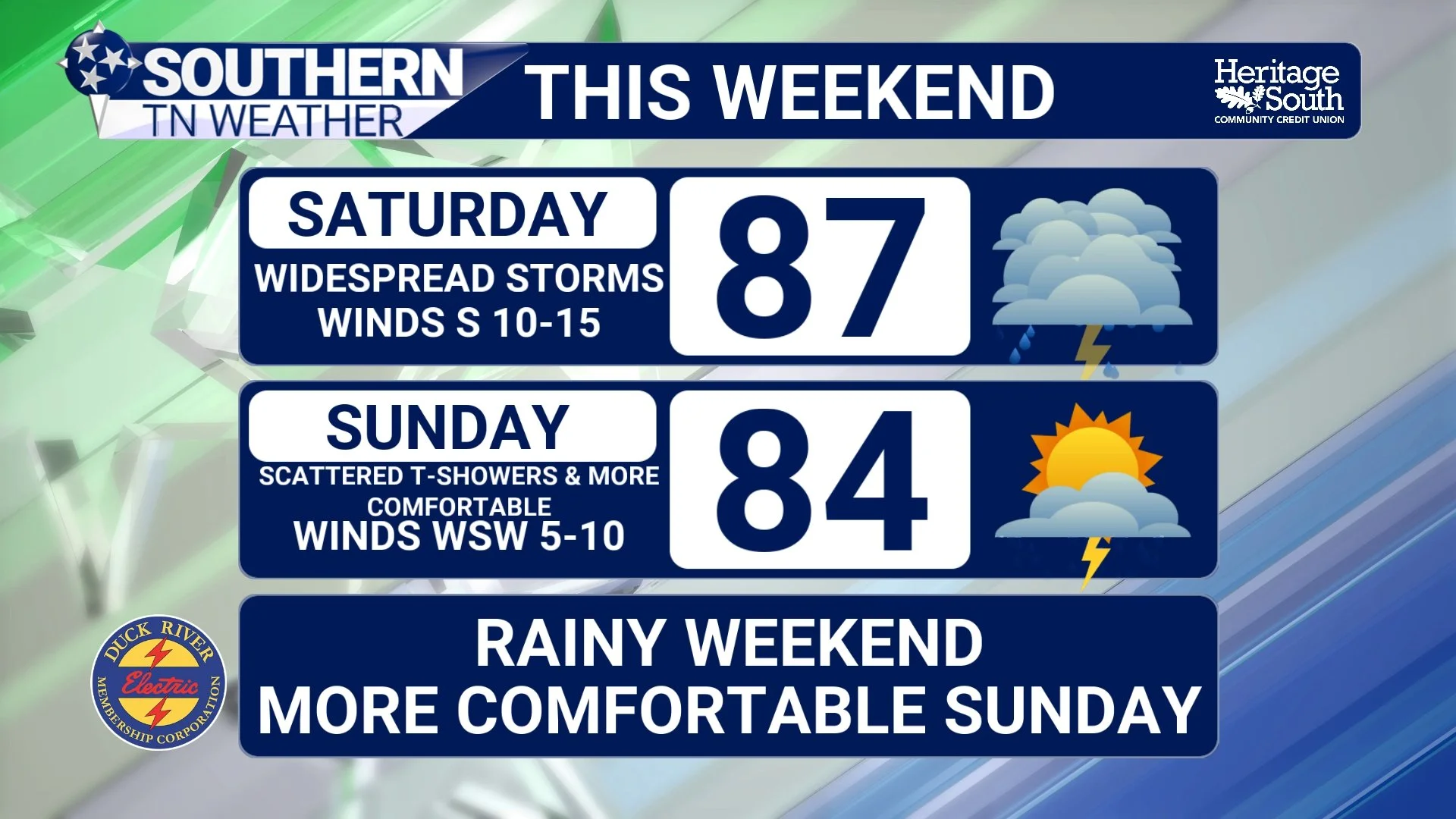
THIS WEEKEND
The Bottom Line 🧾
🌤️ Friday remains dry with sunshine and comfortable humidity.
🌅 The first round of showers and thunderstorms moves through Saturday morning (4 AM–10 AM).
🌩️ A second round develops Saturday afternoon and evening (3 PM–10 PM), bringing the highest chance for strong to severe storms.
💨 Damaging wind gusts over 60 MPH are the primary severe weather threat.
🌧️ Most areas receive 0.25–1.00" of rain, with isolated totals of 2–3" possible.
🌪️ The tornado threat remains very low, but cannot be completely ruled out.
😌 Sunday still features a few lingering showers, but overall conditions gradually improve with noticeably lower humidity returning.
📰 Reminder: The Southern Tennessee Weather Blog, presented by Heritage South Community Credit Union, is updated Monday through Friday with fresh, locally tailored forecasts you can trust.
