
Storm Chances Ticking Up For Saturday: Latest Details Here

The Southern Tennessee Weather Blog is proudly presented by Heritage South Community Credit Union.
We Help When Others Won’t!
Visit https://www.heritagesouth.org/ today to see how HSCCU can help YOU!
If you've been enjoying the break from the heat and humidity over the past couple of days, don't worry—you've still got another beautiful day ahead on Friday. But after that, our attention quickly turns to Saturday, which is shaping up to be our next active weather day. The good news is that this doesn't look like a widespread severe weather outbreak. The bad news? Heavy rain, frequent lightning, and a few stronger thunderstorms could make for a soggy Saturday across Southern Middle Tennessee.
While there are still some questions about exactly when the heaviest rain arrives, confidence continues to increase that Saturday will be our wettest day in over a week.
Friday Remains In Good Shape
Before we get to Saturday, let's not overlook Friday. It'll be another pleasant summer day with highs near 90 degrees and humidity that's still fairly comfortable by late July standards. You'll probably notice the air becoming a little more humid than today as winds turn back out of the south, but most of the daylight hours should remain dry.
Clouds will gradually increase late in the day before showers and thunderstorms begin developing Friday night as our next weather system approaches from the Plains. If you have Friday evening plans, don't cancel them just yet. Many locations may stay dry through much of the evening before rain chances increase overnight.
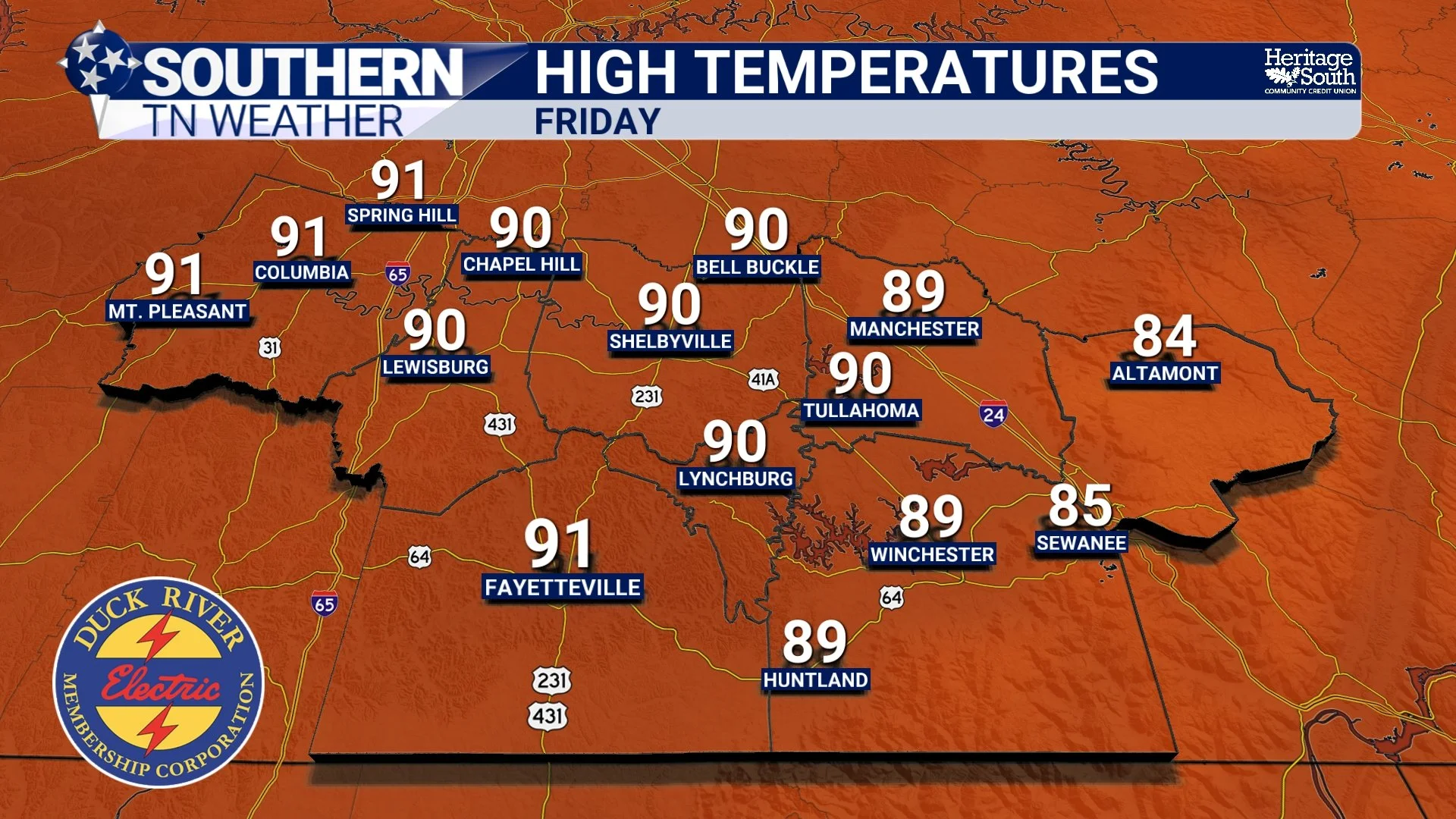
HIGH TEMPS - FRIDAY
Saturday Looks Wet
Current forecast guidance continues to show showers and thunderstorms becoming widespread Saturday morning before continuing on and off through much of the day. Unlike many summertime storms that quickly move through and end, Saturday's setup features a slow-moving cold front interacting with very moisture-rich air. That combination favors repeated rounds of showers and thunderstorms rather than just one quick line moving through.
Not everyone will see rain every minute of the day, but you'll want to keep the umbrella nearby if you have outdoor plans.
Heavy Rain Is The Biggest Concern
At this point, heavy rainfall appears to be the greatest concern. Atmospheric moisture values are forecast to climb to around 2.0 to 2.3 inches, which is exceptionally high for early August. That means any thunderstorm that develops will be capable of producing torrential rainfall in a short amount of time. Another concern is that storms may repeatedly move across the same locations—a process meteorologists call "training." Think of train cars following the same set of tracks. Instead of individual storms moving in different directions, multiple storms could follow one another over the same communities, increasing rainfall totals and creating localized flooding concerns.
The Weather Prediction Center has placed much of Tennessee under a Slight Risk (level 2 out of 4) for Excessive Rainfall on Saturday. That doesn't mean flooding is guaranteed, but it does signal an increased potential for localized flash flooding where the heaviest rain persists. Right now, widespread flooding is not expected, but this is something we'll be watching closely over the next couple of days.
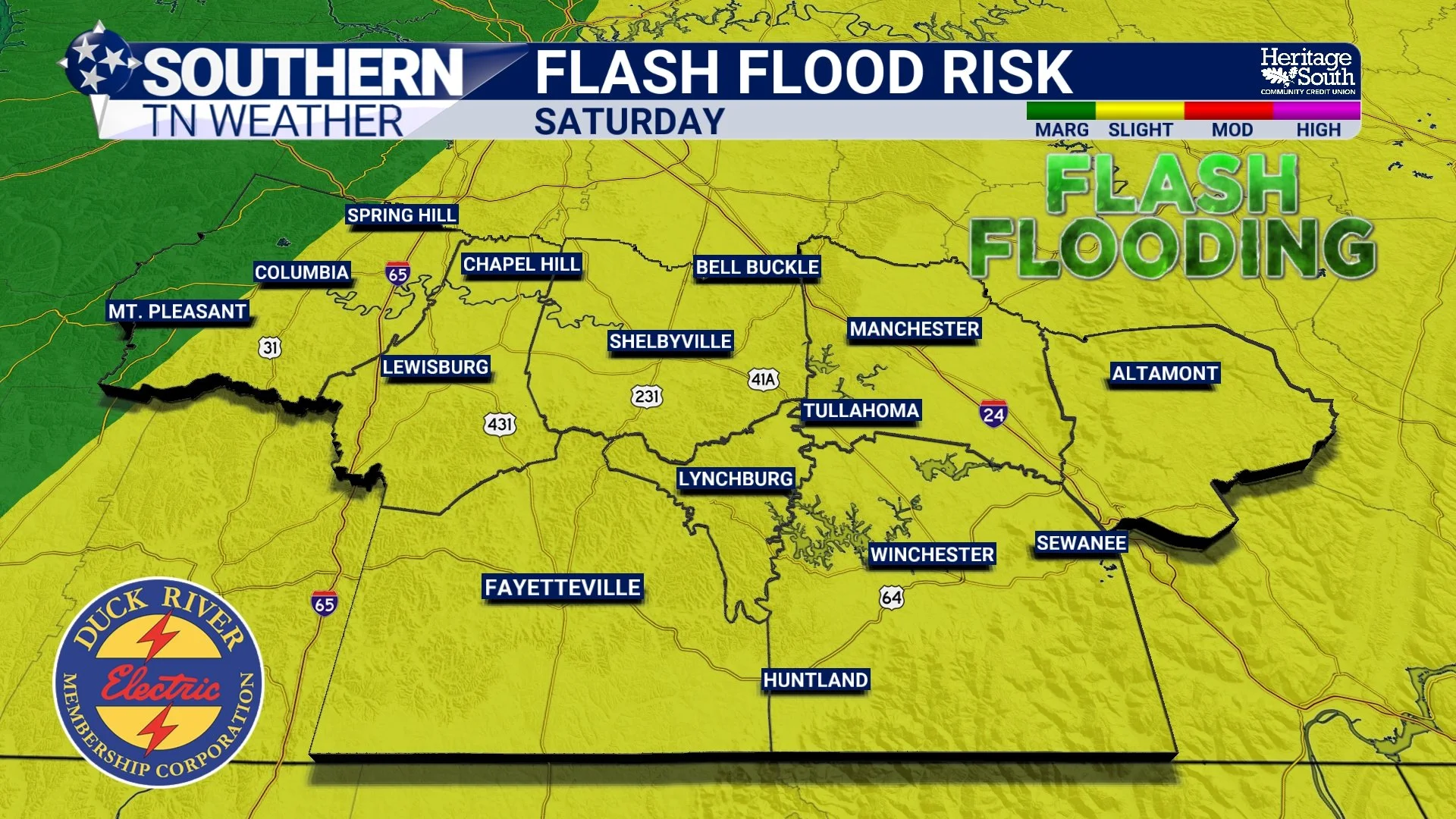
FLASH FLOOD RISK - SATURDAY
What About Severe Weather?
The severe weather threat continues to look fairly limited, but it's NOT completely zero. The Storm Prediction Center has placed our area in a Marginal Risk (Level 1 of 5) for severe thunderstorms on Saturday. Forecast instability will be sufficient for thunderstorms, but wind shear (the ingredient that helps storms become organized) appears fairly weak across most of Southern Middle Tennessee.
Because of that, most storms should remain ordinary summertime thunderstorms. However, a few strong to severe storms could still produce gusty damaging winds, especially Saturday afternoon as the cold front moves through during the warmest part of the day. Frequent lightning will accompany any thunderstorms, and brief torrential downpours will likely be common. Overall, heavy rainfall remains a much greater concern than severe weather.
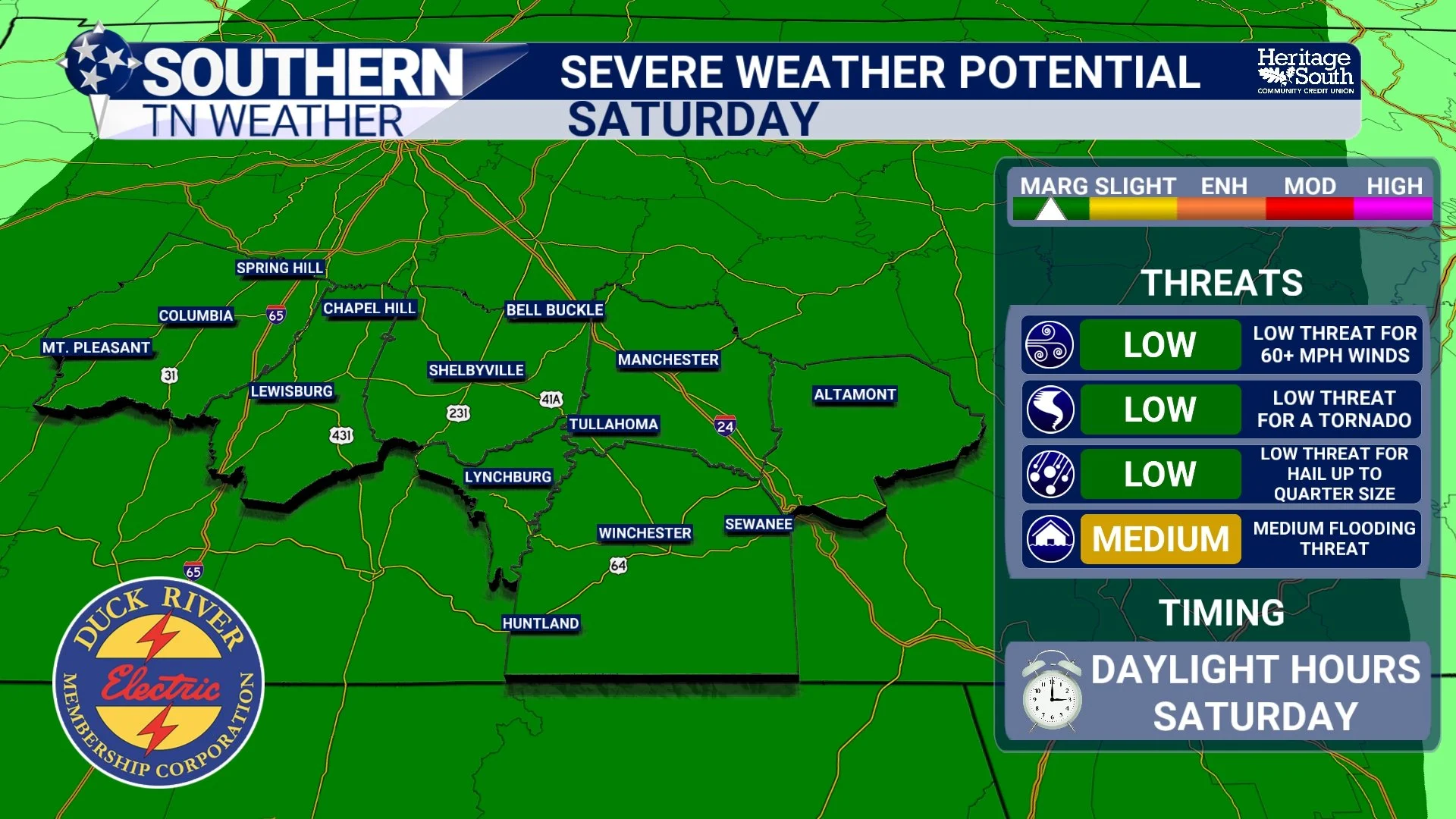
SEVERE WEATHER POTENTIAL - SATURDAY
A Better Finish To The Weekend
The cold front should gradually move east Saturday night, allowing rain to taper off from west to east early Sunday. Sunday isn't expected to be completely rain-free, but shower coverage should be much lower than Saturday, with improving conditions as the day goes on.
Temperatures and humidity will briefly ease again before gradually climbing back toward more typical early August levels next week.
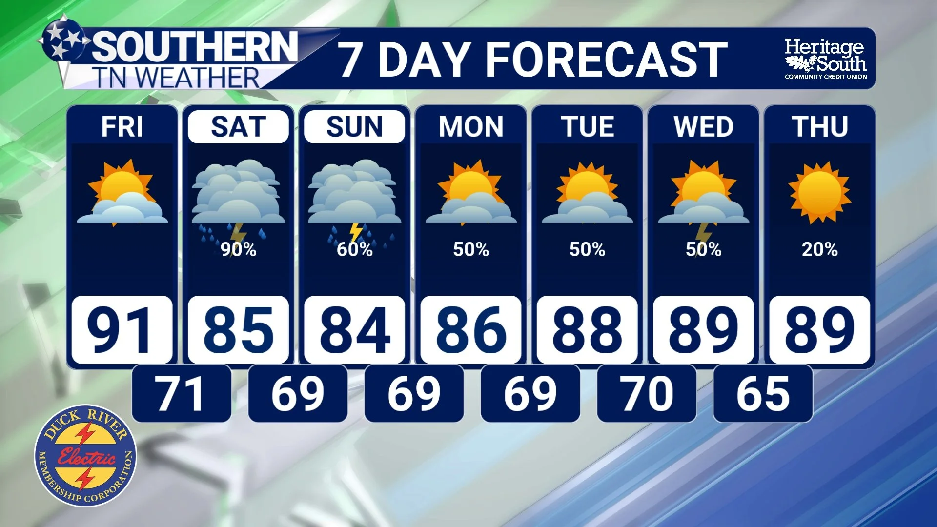
STNWX - 7-DAY FORECAST
The Bottom Line 🧾
🌤️ Friday remains a beautiful day with only increasing clouds late.
🌧️ Showers and thunderstorms become likely Friday night and continue through much of Saturday.
🌊 Heavy rainfall is the primary concern, with localized flooding possible where storms repeatedly move over the same areas.
⚡ A few stronger storms could produce gusty winds, but the overall severe weather threat remains low.
📱 If you have outdoor plans Saturday, keep checking back for forecast updates as timing and rainfall amounts become more refined over the next 24 to 48 hours.
📰 Reminder: The Southern Tennessee Weather Blog, presented by Heritage South Community Credit Union, is updated Monday through Friday with fresh, locally tailored forecasts you can trust.
