
Rain Chances Increase Later This Week, But There's No Major Weather To Worry About

The Southern Tennessee Weather Blog is proudly presented by Heritage South Community Credit Union.
We Help When Others Won’t!
Visit https://www.heritagesouth.org/ today to see how HSCCU can help YOU!
After several weeks of tracking heat advisories, severe weather threats, and flooding concerns, this week's forecast is refreshingly quiet. That doesn't mean we're headed into a completely dry stretch (this is still August in Tennessee) but there simply aren't any major weather systems expected to bring widespread hazardous weather over the next seven days.
Instead, we'll settle into a fairly typical summertime pattern. Temperatures will gradually climb back toward seasonal levels, humidity will slowly increase, and scattered afternoon showers and thunderstorms will become a little more common as we head toward the weekend.
A Slow Warming Trend Begins
Today's temperatures are running several degrees below where we normally find ourselves during early August thanks to an upper-level low spinning just east of the region. That same system has been responsible for the stubborn cloud cover, occasional drizzle, and scattered light showers we've dealt with over the past couple of days, especially across areas along and east of Interstate 65.
As that system gradually weakens and finally begins pulling away, sunshine will become a little more common each day. Afternoon highs will climb from the lower and middle 80s today into the upper 80s and lower 90s by the second half of the week. Humidity will also creep upward, allowing afternoon heat index values to approach the upper 90s and lower 100s by Thursday through the weekend. The good news is that, at least for now, it still appears we'll stay just below Heat Advisory criteria.
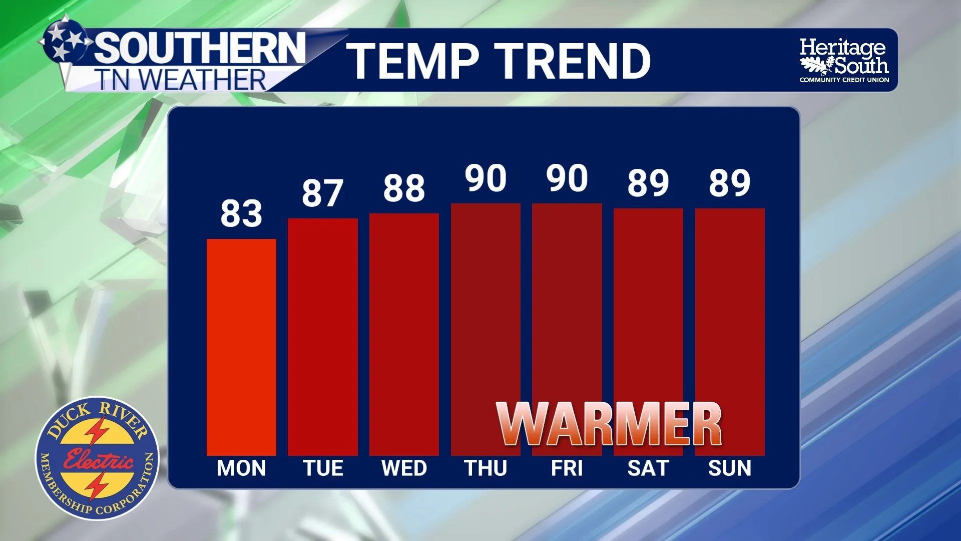
TEMP TREND - NEXT 7 DAYS
Rain Chances are “meh” thru Midweek
The eastern half of Southern Middle Tennessee will continue carrying the best chance for showers Tuesday and Wednesday. That's because the lingering upper-level low will remain close enough to pull moisture back into the region while providing just enough lift to spark scattered afternoon showers and a few thunderstorms. These won't be all-day rains, nor will everyone see precipitation. Instead, expect the typical scattered summertime variety, with many communities staying dry while others pick up a brief downpour.
Any storm that develops could produce lightning and locally heavy rainfall, but the atmosphere lacks the wind shear necessary to organize severe thunderstorms.
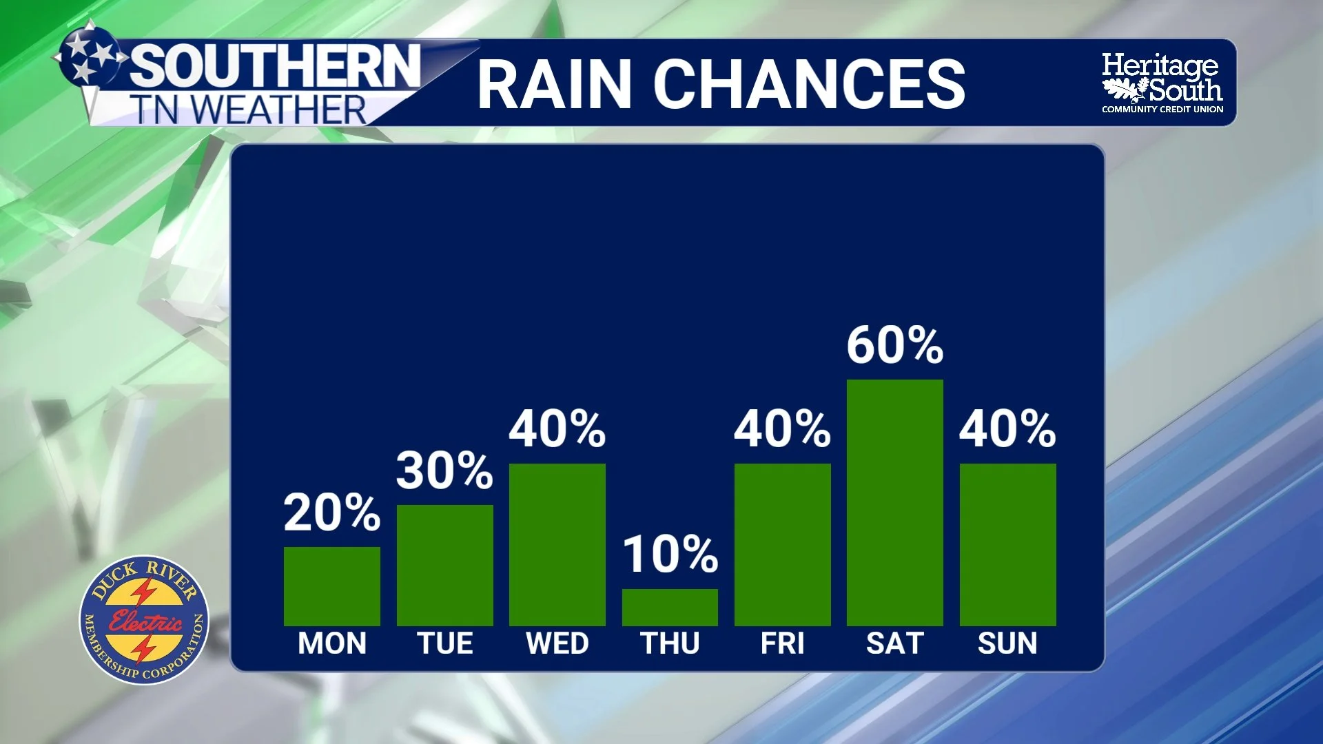
RAIN CHANCES - NEXT 7 DAYS
Weekend Rain Chances Become More Widespread
By Friday, our weather pattern begins shifting once again. A weak upper-level trough and an approaching surface boundary will gradually increase shower and thunderstorm coverage across all of Middle Tennessee as we head into the weekend. Unlike the isolated activity expected over the next few days, rain chances will become much more widespread Saturday and Sunday.
Even so, this doesn't appear to be a particularly concerning setup. Current forecast guidance shows very little support for severe thunderstorms, and neither widespread flooding nor excessive heat appears likely through the weekend. That doesn't mean everyone will stay dry (far from it) but this looks more like a typical August pattern than an organized severe weather event.
Rainfall Won't Be Evenly Distributed
One interesting aspect of this week's forecast is just how uneven rainfall is expected to be across the region. Forecast rainfall totals through Sunday night range from less than a tenth of an inch across portions of western Middle Tennessee to more than an inch across parts of the Cumberland Plateau. That's largely because the eastern half of the state will remain closer to the lingering upper-level disturbance for much of the week before weekend rain chances expand westward.
As always during the summer months, some neighborhoods could easily receive much more rain than others thanks to slow-moving thunderstorms.
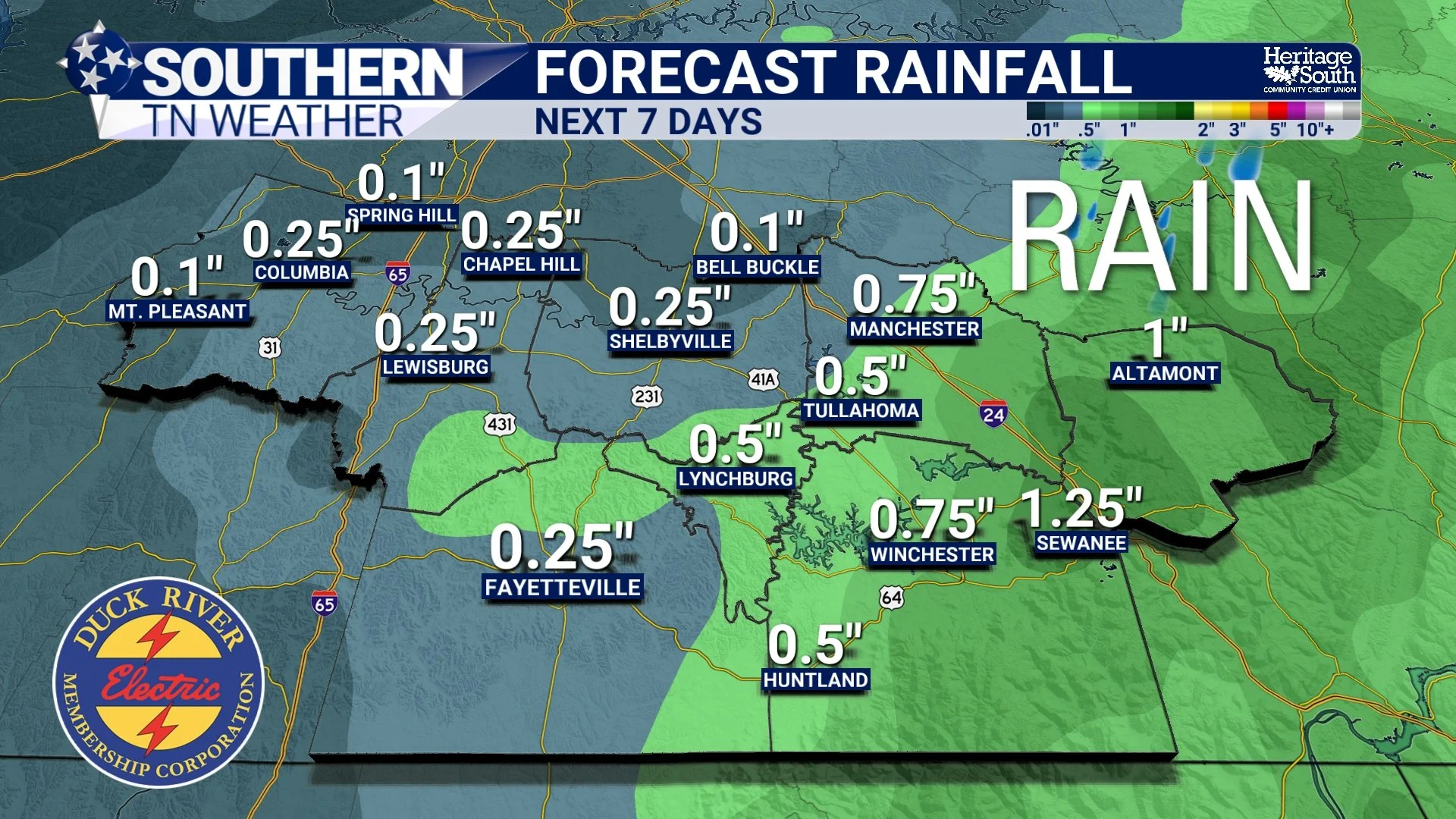
FORECAST RAINFALL - NEXT 7 DAYS
A Typical August Pattern Returns
While recent weeks have featured everything from dangerous heat to flooding rains and multiple severe weather threats, this week looks considerably quieter. We'll continue warming back toward normal August temperatures, humidity will slowly increase, and daily opportunities for scattered showers and thunderstorms will remain in the forecast. That's about as typical as Tennessee weather gets this time of year.
There will certainly be days when you'll want to keep an umbrella nearby, especially later this week, but right now the forecast contains very few signs of widespread hazardous weather.
The Bottom Line 🧾
🌦️ Scattered showers remain most common along and east of Interstate 65 through Wednesday.
🌡️ Temperatures gradually warm back into the upper 80s and lower 90s by late week.
🥵 Heat index values may approach 100° later this week but should remain below Heat Advisory criteria.
⛈️ Rain and thunderstorm chances become more widespread Friday through the weekend.
⚠️ Severe weather, flooding, and dangerous heat all appear unlikely over the next seven days.
☀️ Expect a fairly typical August weather pattern with warm afternoons and occasional scattered storms.
📰 Reminder: The Southern Tennessee Weather Blog, presented by Heritage South Community Credit Union, is updated Monday through Friday with fresh, locally tailored forecasts you can trust.
