
Weather Refresher: Straight-Line Winds vs. Tornadoes

The Southern Tennessee Weather Blog is proudly presented by Heritage South Community Credit Union.
We Help When Others Won’t!
Visit https://www.heritagesouth.org/ today to see how HSCCU can help YOU!
After the storms we experienced across parts of Southern Middle Tennessee over the weekend, I saw a familiar question pop up again: “Was that a tornado?”
It's an understandable question. When a thunderstorm produces winds strong enough to snap trees, damage buildings, toss debris and send rain blowing sideways, our minds naturally jump to tornadoes. It can become even more confusing when the wind or rain appears to be swirling, changing direction or wrapping around buildings and trees. But damaging wind does NOT automatically mean a tornado occurred, and seeing something swirl during a thunderstorm doesn't necessarily mean you're witnessing tornado-like rotation.
We've talked about this before, but after this weekend I thought it would be a good time for another WEATHER REFRESHER and to go a little deeper into the science. Straight-line winds, downbursts and tornadoes can all produce significant damage, but they develop in very different ways. And believe it or not, there's a perfectly good reason why genuinely straight-line thunderstorm winds can sometimes look anything but straight once they reach the ground.
Straight-Line Winds and Tornadoes Are Very Different
The fundamental difference comes down to how the air is moving. A tornado is a violently rotating column of air extending from a thunderstorm to the ground. Straight-line winds, on the other hand, are produced by thunderstorm downdrafts and generally spread outward once that descending air reaches the surface.
Thunderstorms contain tremendous amounts of moving air. Warm, moist air rises within an updraft, while cooler, denser air can descend elsewhere in the storm as a downdraft. Rain falling through relatively dry air can enhance that downdraft through evaporative cooling, making the descending air even cooler and heavier. Eventually, that mass of air reaches the ground, and because it obviously can't continue traveling downward through the surface, it spreads horizontally.
Think about pouring a bucket of water straight down onto a concrete driveway. The water hits the ground and immediately races outward. A thunderstorm downdraft behaves somewhat similarly, except we're dealing with air moving at potentially tremendous speeds.
When a concentrated area of particularly strong descending air reaches the surface and spreads outward, we call it a downburst. Smaller, more concentrated downbursts are often called microbursts. These events can produce winds strong enough to snap large trees, remove portions of roofs, overturn objects and bring down power lines.
That's also why I don't like the tendency to think of straight-line wind as the “less serious” alternative to a tornado. A 70 or 80 MPH wind gust doesn't suddenly become harmless because it wasn't produced by a tornado. In some particularly intense thunderstorm wind events, speeds can become even higher. A large oak tree doesn't particularly care whether the wind that knocks it onto your house came from a rotating tornado or a powerful downburst.
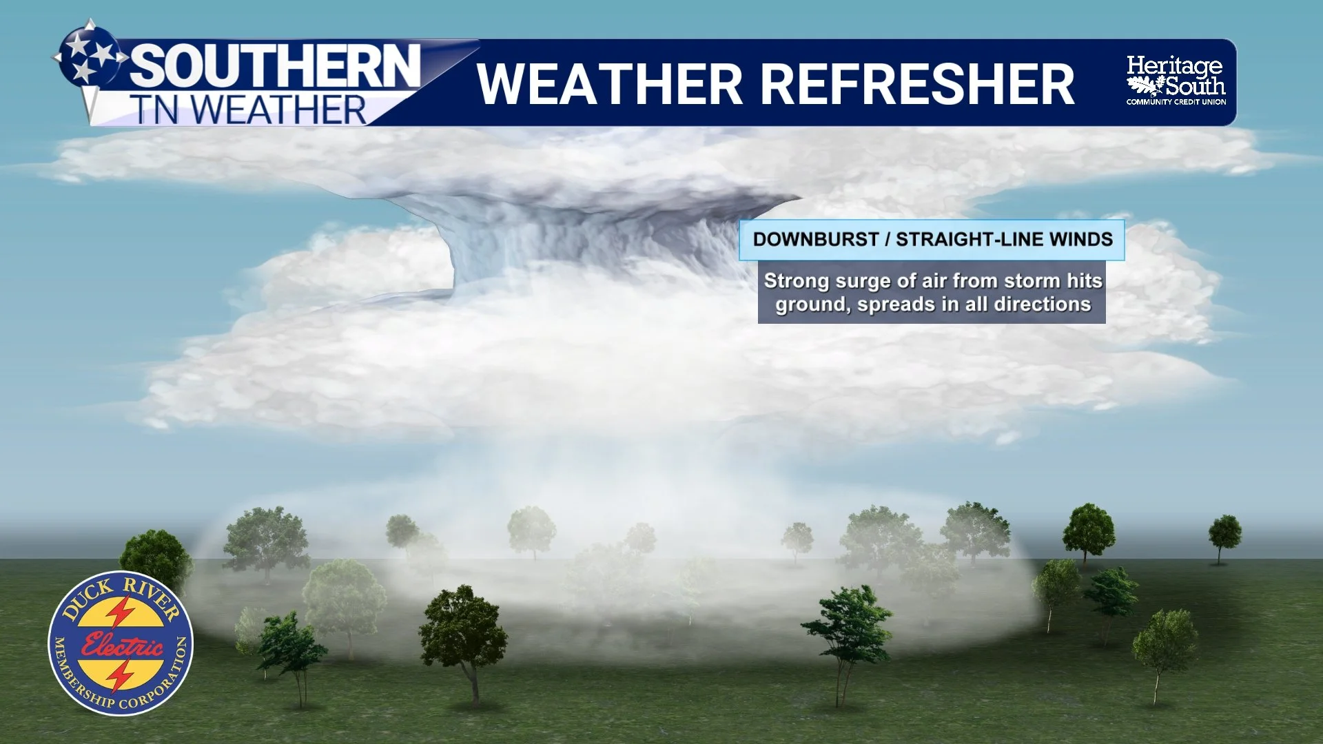
WEATHER REFRESHER - DOWNBURSTS / STRAIGHT LINE WINDS
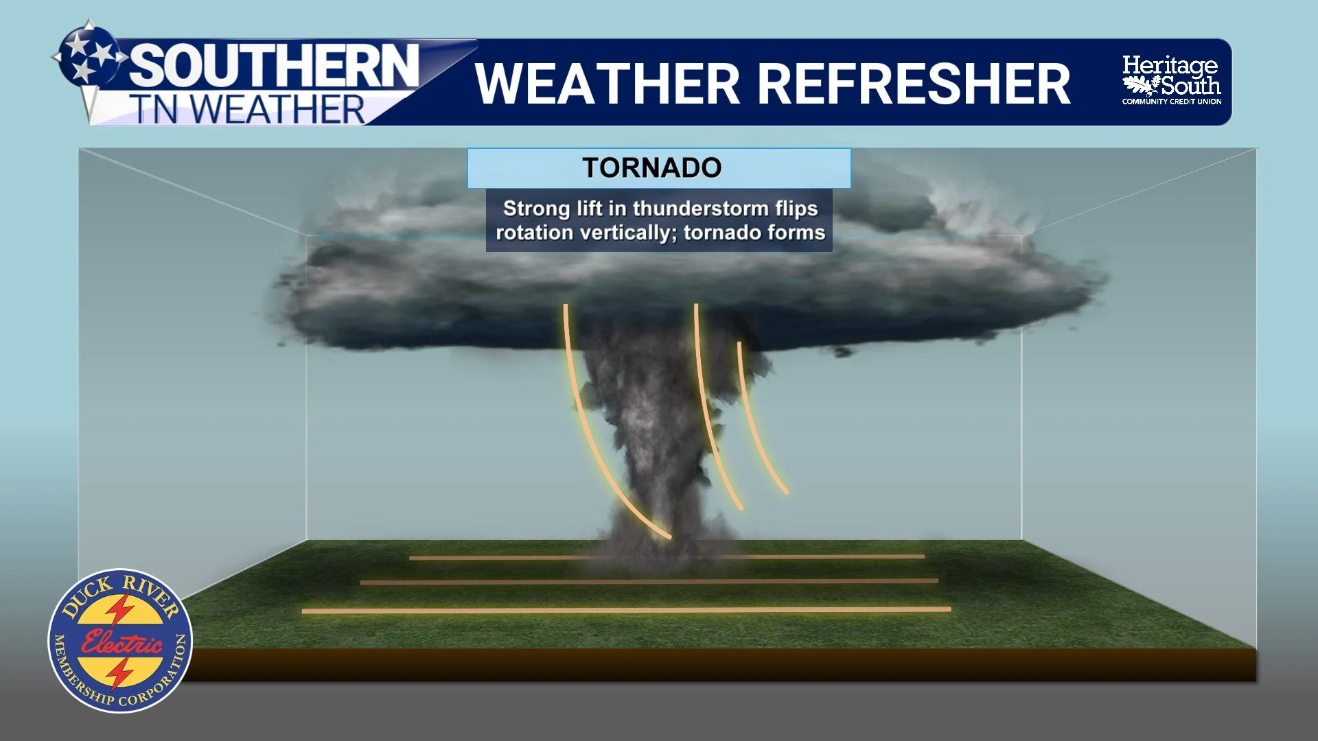
WEATHER REFRESHER - TORNADOES
If They're “Straight-Line” Winds, Why Can They Look Like They're Swirling?
This is probably the biggest source of confusion, and it's something worth spending a little more time explaining. The term straight-line wind describes the overall character of the thunderstorm wind compared with the organized rotating circulation of a tornado. It does NOT mean every individual parcel of air travels in a perfectly straight line from Point A to Point B.
The atmosphere near the ground is messy. Southern Middle Tennessee certainly isn't a giant flat parking lot. We have hills, valleys, forests, tree lines, houses, barns and countless other obstacles. When a powerful rush of thunderstorm wind reaches the surface, all of those obstacles interfere with the airflow. Wind is forced around buildings, over hills, between trees and through narrow spaces. That interaction creates turbulence, and within turbulent flow you can develop small rotating pockets of air known as eddies.
A creek provides a really good comparison. The overall current may be flowing steadily downstream, but put a large rock in the middle of that current and you'll often see little whirlpools develop behind or alongside it. The water is still generally traveling downstream, but locally, some of it may briefly swirl around in circles. Air can behave the same way.
Imagine a downburst producing winds generally moving from northwest to southeast. That wind reaches a house and is forced around both sides of it. Behind the house, those different streams of turbulent air can interact and create small eddies. Leaves may suddenly circle around, rain may appear to curl back in another direction and lightweight debris might briefly get tossed upward or sideways. Similar turbulence can develop around tree lines, barns, hills and even differences in terrain.
Surface friction adds another layer of complexity because the wind immediately near the ground is slowed and disrupted much more than the air slightly above it. Put all of that together during a 60, 70 or 80 MPH thunderstorm gust and the resulting scene can look incredibly chaotic. That means someone standing inside a house and looking through a rain-covered window could absolutely see rain or debris “swirling” during a straight-line wind event. They aren't necessarily imagining it. There really can be small-scale rotation occurring within turbulent airflow. What they're seeing, however, is not automatically a tornado.
The difference is scale, structure and origin. A tornado involves an organized rotating circulation connected to the thunderstorm above it. A turbulent eddy created as straight-line winds interact with a house or tree line is a much smaller feature embedded within an overall outward-moving wind field.
Rain Curtains Can Make Things Look Even More Dramatic
Heavy rainfall makes distinguishing the two with your eyes even more difficult. A strong downburst can bring a wall of torrential rain toward you while powerful winds bend that rain sideways. Turbulence can make one portion of the rain curtain move differently from another, while trees bend in different directions and debris becomes airborne. Add poor visibility, lightning and darkness, and the entire scene can look downright terrifying.
This is one reason I caution against trying to determine whether something is a tornado simply by looking outside. Even trained meteorologists can't always look at a shaky nighttime video of rain and debris and immediately determine exactly what happened.
Instead, we use multiple pieces of evidence. Doppler radar allows meteorologists to examine wind moving toward and away from the radar and identify organized rotation within a thunderstorm. We can also examine the storm's structure, environmental conditions and reports from trained spotters. If significant damage occurs, National Weather Service meteorologists may conduct a storm survey to determine what produced it.
Damage patterns can provide important clues. Because a downburst reaches the ground and spreads outward, damage often exhibits a divergent or fan-like pattern. Tornado damage, meanwhile, can exhibit evidence of convergence and rotation along a more concentrated path. But even that isn't as simple as looking at one fallen tree and deciding which way the wind blew. Terrain, buildings, the health and shape of a tree, previous damage and turbulent eddies can all affect how individual objects fall. Meteorologists therefore examine the overall damage pattern rather than relying on one tree, one roof or one eyewitness account.
A Storm Doesn't Need Rotation to Be Dangerous
Another misconception is that a thunderstorm must be rotating to produce serious wind damage. It doesn't. Some tornado-producing thunderstorms, particularly supercells, contain organized storm-scale rotation that meteorologists can identify on Doppler radar. But a thunderstorm with little or no meaningful rotation can still produce an intense downdraft and damaging straight-line winds. Likewise, detecting rotation within a thunderstorm does not automatically mean a tornado is occurring at the ground.
This distinction is also why Severe Thunderstorm Warnings deserve more respect than they sometimes receive. A Tornado Warning means a tornado has been indicated by radar or observed and you should immediately move to your tornado safe place. A Severe Thunderstorm Warning means a storm is capable of producing severe hazards such as damaging winds and/or large hail. Depending on the magnitude of the wind threat, some severe thunderstorms can be exceptionally dangerous.
If a storm is capable of producing winds strong enough to knock trees onto homes, standing on the porch to determine whether the rain is “rotating” isn't particularly useful. Get inside, stay away from windows and let the storm pass. Whether those damaging winds came from a tornado, downburst or another thunderstorm wind feature can be sorted out afterward.
A Quick Look at the Forecast
Thankfully, we're not expecting a significant severe-weather threat across Southern Middle Tennessee this Labor Day. Most communities should remain dry this afternoon, although a few isolated showers or thunderstorms could develop, particularly along and east of I-65 and toward the Cumberland Plateau. Any stronger storm that manages to develop could produce gusty winds and locally heavy rainfall, but widespread severe weather is not expected.
Tuesday and Wednesday look much quieter as high pressure strengthens over the Southeast. Both days should be largely dry, with highs climbing into the lower 90s Tuesday and middle 90s Wednesday. Wednesday currently looks like the hottest day of the week, and feels-like temperatures could creep a little above 100° in some locations.
Our next more meaningful opportunity for showers and thunderstorms arrives Thursday into Friday as another front approaches the region. Rain chances increase considerably during that period, but at this point the atmospheric setup does not look particularly favorable for widespread severe weather. There may be enough instability and wind shear for a stronger storm or two, so we'll continue watching trends over the next several days. Scattered rain chances may linger into the weekend while temperatures remain quite warm, generally in the upper 80s and lower 90s.
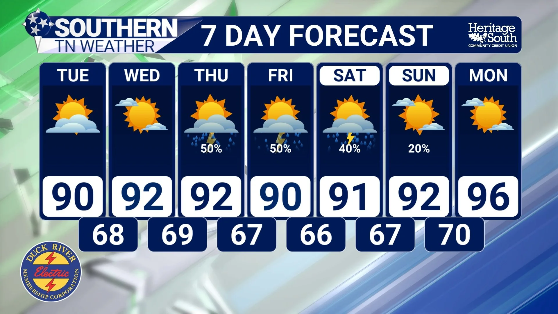
STNWX 7-DAY FORECAST
The Bottom Line 🧾
🌪️ A tornado is an organized, violently rotating column of air extending from a thunderstorm to the ground.
💨 Straight-line winds generally spread outward from thunderstorm downdrafts and can cause significant damage without a tornado.
⬇️ Downbursts and microbursts can produce winds strong enough to damage buildings, snap trees and bring down power lines.
🌀 Straight-line winds can absolutely LOOK like they're swirling. Buildings, trees, hills and surface friction create turbulence and small rotating eddies within the larger wind flow.
🌧️ Heavy rain curtains and blowing debris can make those small-scale swirls appear even more dramatic.
🌳 Meteorologists use radar, storm structure, reports and overall damage patterns to determine whether a tornado occurred.
⚠️ Straight-line winds can be every bit as dangerous as a weak tornado. Take Severe Thunderstorm Warnings seriously.
⛈️ An isolated storm is possible mainly east of I-65 this Labor Day afternoon, but severe weather is not expected.
☀️ Tuesday and Wednesday look hot and mainly dry before rain and storm chances increase Thursday and Friday.
📰 Reminder: The Southern Tennessee Weather Blog, presented by Heritage South Community Credit Union, is updated Monday through Friday with fresh, locally tailored forecasts you can trust.
